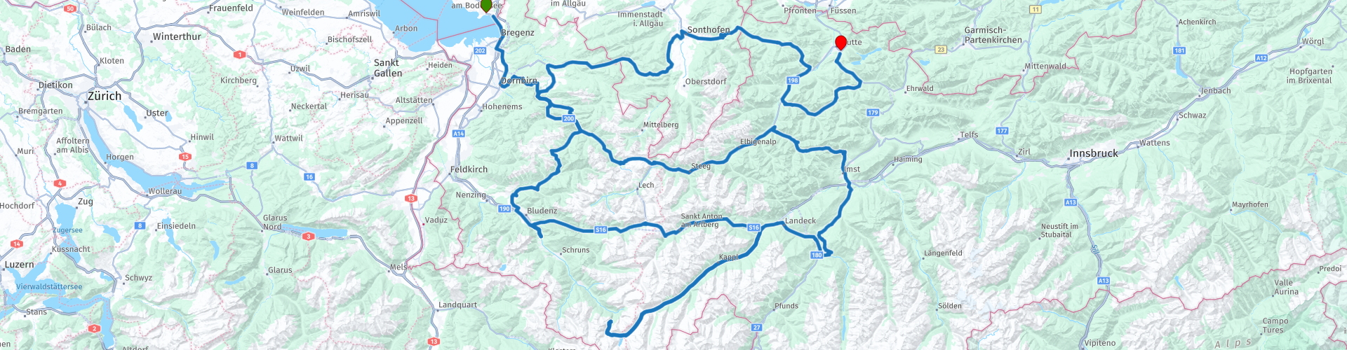
Bodensee naar de Fernpas

This route was brought to you by:
RouteXpert Hans van de Ven (Mr.MRA)
Last edit: 11-02-2023
 Route Summary
 Start: Lindau am Bodensee.
Finish: Reutte
The route made the same for TomTom, Garmin and MyRoute-app Navigation users.
If you want to ride this TT, keep the info below in mind:
- No mountain experience
- TT from A to B
- Accommodation necessary
- Tol
Source: Promoter 07, September / October 2018.
 Share this route


Animation

Verdict


Duration
8h 38m

Mode of travel
Car or motorcycle

Distance
489.59 km

Countries


 RouteXpert Review
 Faschinajoch (1486 m), Furkajoch (1761 m), Silvretta-HochalpenstraßeBielerhöhe (2036 m), Piller Höhe (1558 m), Hahntennjoch (1894 m), Hochtannbergpass (1676 m), Riedbergpass (1420 m), Oberjoch-Pass (1178 m) ), Gaichtpas (1093 m).
This 5-star route is one of the 24 most beautiful Alpine routes in recent years!
Colored route points:
rp 1 - Bodensee hotel
rp 11 - Faschinajoch
rp 12 - Fontanella viewpoint
rp 13 - Coffee stop Gasthaus Löwen
rp 17 - Lunch stop Restaurant Silvrettasee
rp 18 - Bieler Höhe
rp 28 - Tank stop at avanti
rp 34 - Hochtannbergpass
rp 35 - Coffee stop at Landhaus Bad Hopfreben
rp 36 - Schnepfegg
rp 37 - Hinter Schnepfegg viewpoint
rp 43 - Coffee stop at Hornstüble
rp 48 - Oberjochpass
rp 55 - Tank stop Jet
rp 56 - End point at Gasthof Goldene Krone
Route details:
- Silvretta-Hochalpenstraße winter closure November to June, Hochtannbergpass December to April.
- Tol Silvretta-Hochalpenstraße, Kaunertaler Gletscherstraße
-Alternative routes Furka passLaternser Tal, Kaunertaler Gletscherstraße
- Ideal months End of May to mid July, end of August to mid November
- Riding pleasure Bödele, between Dornbirn and Schwarzenberg in the Bregenzer Wald, FurkajochLaternser Tal, Piller Höhe, Hahntennjoch, Namloser TalBerwanger Tal
- Landscape Bregenzer Wald, Großes Walsertal, Silvretta-Hochalpenstraße, Piller Höhe, Hahntennjoch, Lechtal, Riedbergpass, Tannheimer Tal


 Usage
Usage Want to download this route?
You can download the route for free without MyRoute-app account. To do so, open the route and click 'save as'. Want to edit this route?
No problem, start by opening the route. Follow the tutorial and create your personal MyRoute-app account. After registration, your trial starts automatically.  Disclaimer
Use of this GPS route is at your own expense and risk. The route has been carefully composed and checked by a MyRoute-app accredited RouteXpert for use on TomTom, Garmin and MyRoute-app Navigation.
Changes may nevertheless have occurred due to changed circumstances, road diversions or seasonal closures. We therefore recommend checking each route before use.
Preferably use the route track in your navigation system. More information about the use of MyRoute-app can be found on the website under 'Community' or 'Academy'.