Vom Mauthen to Vigo di Cadore Rundtour mit 6 paesse

This route was brought to you by:
RouteXpert Chantal HV
Last edit: 12-04-2020
 Route Summary
 Real insider tips in the Carnic Alps!
Nassfeld Pass, Lanzen Pass, Passo del Pura, Sella di Razzo, Sella del Monte Zoncolan and Plöcken Pass await you on this demanding route through the Carnic Alps. Almost 6,000 meters of altitude are overcome and passes are overpassed with the Lanzen Pass and the Sella del Monte Zoncolan, which were only recently paved on both sides for the first time. So you can really speak of real insider tips!
 Share this route


Animation

Verdict


Duration
5h 54m

Mode of travel
Car or motorcycle

Distance
237.90 km

Countries


 RouteXpert Review
 Falls under the category "heavy" (Austria uses "easy, medium and hard"). Wide roads here and there, but also much narrower streets and passes, sometimes very steep and winding. Sufficient stops on the way with a nice view or to eat or drink. That's why I give this route 5 stars
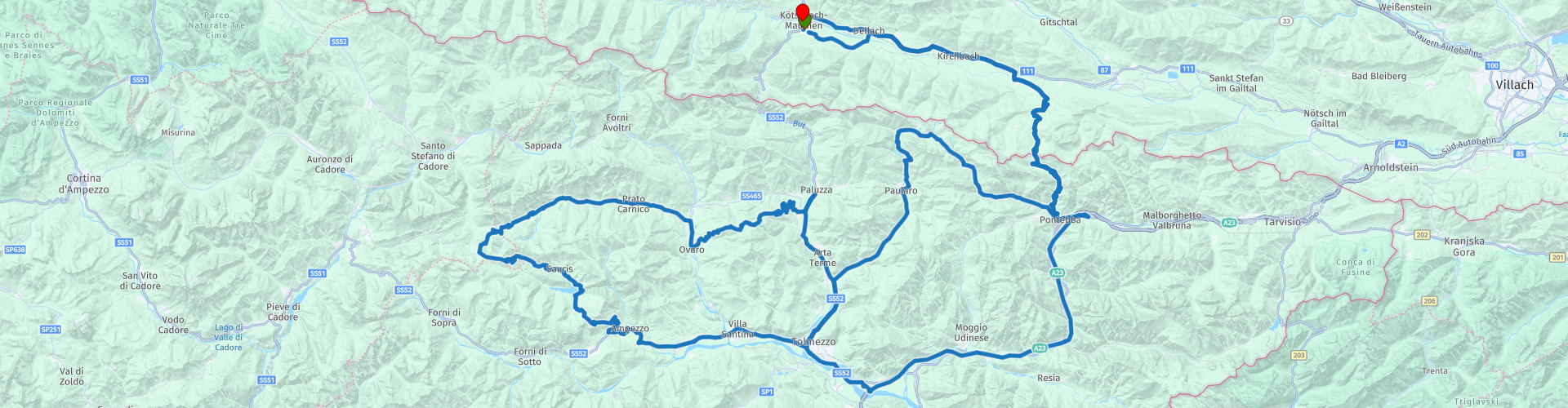
From Kötschach-Mauthen away, we warm up through the Upper Gail Valley to Tröpolach, the valley of Carinthia's largest alpine ski area Nassfeld. The ride over that Nassfeld (Passo Promollo) is also part of the Carnic Dolomite Road, but we leave again at Pontebba. In a northwesterly direction it is now to Studena alta and always along the Wilbach Pontebbana on the 1,552 high located Lanzenpass. The last few kilometers up to the pass were recently paved, mainly because of the Giro d'Italia cycling tour. So this pass is still relatively new territory for motorcyclists and road cyclists - a real insider tip! At the top of the pass you will find alpine pastures and dairies, there is also a managed hut and the further descent to the village of Paularo is very steep and winding. From Paularo continue south to Tolmezzo. We continue westwards to Villa Santina and there we continue towards Passo della Mauria, which is not on our route, as we already drive a few km to Ampezzo north towards Passo del Pura (1,428 m) and then on to Lago di Sauris or the places located there Sauris di sotto and Sauris di sopra. Sauris (to German years) is a small German language island with about 400 inhabitants where even today "Zahrisch", a dialect influenced by Pustertal elements, is spoken. Sauris is also known for its exclusive and exquisite Prosciutto, which owes its mild taste to the exclusive smoking of beechwood.
From Sauris we continue to the fourth and with 1,739 m highest pass of this tour: the Sella di Razzo. A few kilometers we are here in the region of Veneto before we drive over the Val Pesarina, one of the seven Carina valleys back to the east. This narrow valley is characterized by dense forest and very long straights - that is, little curves. At Comeglians we reach the Val Degano and turn right, so south towards Ovaro. Here begins the driveway on the - especially among cycling fans known - Sella del Monte Zoncolan. The Zoncolan gained fame as it is one of the steepest mountains in professional cycling and time and again stage destination at the Giro d'Italia. In almost every corner, therefore, former cycling heroes are immortalized on display boards. Where racing cyclists are but also motorcyclists and thus, these two groups share this mountain road. At the pass of the Zoncolan on about 1,700 vertical meters is a small ski area with some good rest stops. We then continue down to the valley to Sutrio, one of the oldest settlements in Carnia and we are back there again on the Carnic Dolomites Road. To the north it goes to the Plöckenpass where again the border to Austria / Carinthia is crossed. At Plöckenpass there is an open-air museum, which illustrates the fortifications from the First World War. In the valley and destination of this tour, in Kötschach-Mauthen is the Museum 1915-1918, (RP 28) operated by the Association of Friends of the Dolomites.


 Links
Links  Usage
Usage Want to download this route?
You can download the route for free without MyRoute-app account. To do so, open the route and click 'save as'. Want to edit this route?
No problem, start by opening the route. Follow the tutorial and create your personal MyRoute-app account. After registration, your trial starts automatically.  Disclaimer
Use of this GPS route is at your own expense and risk. The route has been carefully composed and checked by a MyRoute-app accredited RouteXpert for use on TomTom, Garmin and MyRoute-app Navigation.
Changes may nevertheless have occurred due to changed circumstances, road diversions or seasonal closures. We therefore recommend checking each route before use.
Preferably use the route track in your navigation system. More information about the use of MyRoute-app can be found on the website under 'Community' or 'Academy'.