R02 VIC NSW Wangaratta to Canberra

This route was brought to you by:
RouteXpert Hans van de Ven (Mr.MRA)
Last edit: 15-04-2021
 Route Summary
 Australia is very large; 8 million km2, that is more than 226 times larger than the Netherlands! Has a diversity of flora and fauna; the most diverse types of plants, trees and animals, especially birds and a lot of typical Australian marsupials, that you won't find anywhere else in the world!
Enormous enjoyment of all the beautiful things: From the always green tropical rain forests to the vast Outback; from the desert to the countless and tranquil idyllic palm beaches; from the winter sports areas in the southeast to the bustling and impressive millions of cities of Melbourne, Sydney and Perth.
You will see and experience it all in this great tour through Australia, a tour you will never forget!
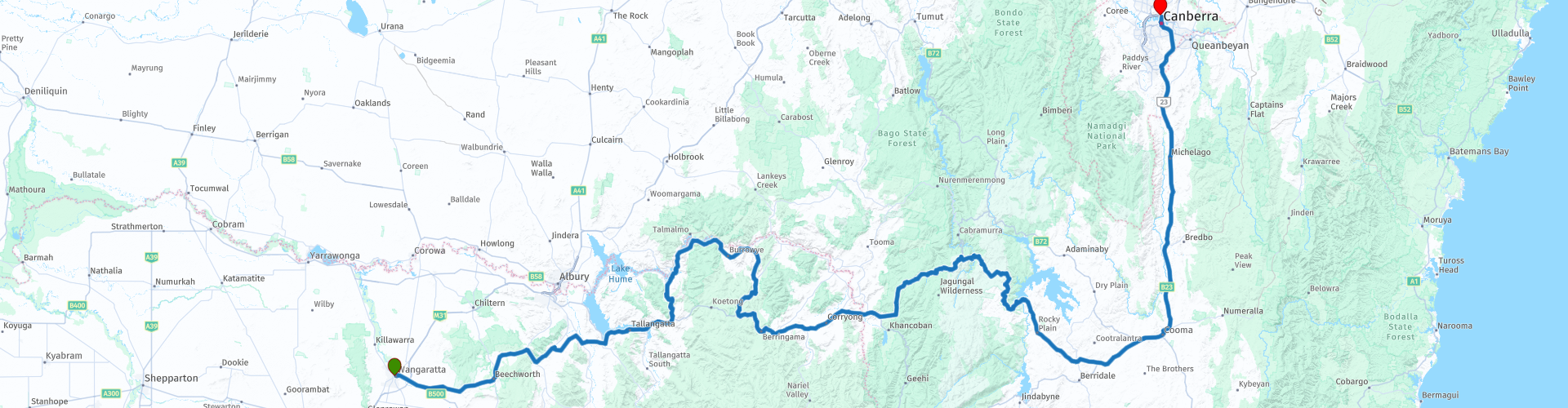
Starting point: Wangaratta, Parkview Motor Inn.
End point: Canberra, Peppers Gallery Hotel
The route has been made the same for TomTom, Garmin and MyRoute-app Navigation users.
ATTENTION: LEFT DRIVING!
 Share this route


Animation

Verdict


Duration
10h 37m

Mode of travel
Car or motorcycle

Distance
547.63 km

Countries

 RouteXpert Review
 You leave Wangaratta via the Great Alpine road, but you can first do some shopping at the supermarket for some goodies en route. After a little less than 9 KM, you can stand still for a moment at the Fire Fighters Memorial and then turn left towards Beechworth, where you can also take a picture of the Newtown Falls. Then head towards Yackandandah, Yackandanda, this is a small tourist town in northeastern Victoria. It is near the regional towns of Wodonga and Albury and close to the tourist town of Beechworth. At the 2011 census, Yackandandah had 950 inhabitants. You will pass successively Lake Hume and Tallangatta, where you can stop for coffee and a sandwich and refuel.
After coffee you go through different state / nature parks, you start with the Mount Granya State Park is a 6,140 hectare state park near Wodonga on the northern border of Victoria. It is named after Mount Granya, a peak of 870 m. The terrain is generally steep and rocky with eucalyptus forest and low shrub. Then the Mount Lawson State Park is a park of 13,150 hectares, about 60 km east of Wodonga in the state of Victoria. It was protected for its varied vegetation, rare flora and fauna, aesthetic qualities and cultural heritage. Then the Burrowa-Pine Mountain National Park is a national park in the Hume region of Victoria. The 18,400-hectare national park is located approximately 315 kilometers northeast of Melbourne and 120 kilometers east of Albury-Wodonga.
In Corryong, this is a small town in Victoria, 120 kilometers east of Albury-Wodonga, near the headwaters of the Murray River and close to the New South Wales border. At the 2016 census, Corryong had a population of 1,348. The post office was opened on 1 February 1874. You can stop for lunch and refuel. After lunch you go through the National Park Kosciuszko, this is a 6,900 square kilometer national park and contains the highest mountain of mainland Australia, Mount Kosciuszko, after which it is named, and Cabramurra the highest city in Australia. It contains a mix of rugged mountains and wilderness, characterized by a mountain climate, making it popular with recreational skiers and bush walkers. The park is located in the southeastern corner of New South Wales, 354 km (220 miles) southwest of Sydney and borders the Alpine National Park in Victoria in the south and the Namadgi National Park in the Australian Capital Territory in the northeast. The larger cities of Cooma, Tumut and Jindabyne are just outside the park. The waters of the Snowy River, the Murray River and the Gungarlin River all rise in this park. Other notable peaks in the park are Gungartan, Mount Jagungal, Bimberi Peak and Mount Townsend. On November 7, 2008, the park was added to the Australian National Heritage List as one of the eleven areas that make up the national parks and reserves of the Australian Alps.
For the next coffee stop you pass Lake Eucumbene, and the coffee stop is in the town of Cooma, this is a city in the south of New South Wales. It lies 114 kilometers south of the national capital Canberra, via the Monaro Highway. It is also located on the Snowy Mountains Highway and connects Bega with the Riverina. At the 2016 census, Cooma had a population of 6,742. After coffee it goes in a straight line to Canberra and you pass the Namadgi National Park, this is a protected area in the southwest of the Australian Capital Territory, adjacent to the Kosciuszko National Park in New South Wales. It is located approximately 40 kilometers southwest of Canberra. Once in Canberra, you first refuel and then to the hotel.
This route, rated with 4 stars, is mainly about beautiful roads, through beautiful nature reserves and occasionally over gravel roads.
General info:
New South Wales is a state of Australia with Sydney as its capital, and is often abbreviated to NSW. The three most important cities are, from north to south, Newcastle, Sydney and Wollongong, which are all on the coast. Other cities are Albury, Broken Hill, Dubbo, Tamworth, Armidale, Lismore, Nowra and Coffs Harbor.
The state is located on the east coast of the continent, north of the state of Victoria and south of the state of Queensland. In the west it borders South Australia. The coast borders the Tasman Sea. New South Wales has two federal enclaves: the Australian Capital Territory (ACT) and the Jervis Bay Territory.
New South Wales can be physically divided into four parts; 1. A narrow coastal strip, with a climate whose temperature varies from temperate on the far south coast to subtropical on the Queensland border. 2. The mountainous areas of the Great Australian Divorce Mountains and the highlands that surround it, such as the Southern Highlands, Central Tablelands and the regions of New England. Even though the mountain walls are not very steep, many mountain tops exceed 1000 meters, of which Mount Kosciuszko reaches 2229 meters as the highest peak. 3. The agricultural plains, which make up a large part of the area of the state. These areas are much less densely populated than the coast. This part includes the Riverina region. 4. The dry, desert-like plains in the far north-west of the state, which are unsuitable for settlements of any size.
It is the oldest colony of the former Australian colonies of the United Kingdom. The colony was founded in 1788 and originally included much more of the Australian mainland. At that time, the western half of the colony was called New Holland and the eastern half was New South Wales. New Holland was controlled from Sydney.
During the nineteenth century, large areas were separated around the British colonies Van Diemen's Land (Tasmania) (1825), Victoria (1851), Queensland (1859) and South Australia (1836) (which at that time also included the Northern Territory) to shape. These colonies and Western Australia voted in 1901 to continue together as the Commonwealth of Australia.
Tourist attractions in the state include; The Blue Mountains, west of Sydney, a national park including the Three Sisters rock formation; The Hunter Valley, 150 km north of Sydney, the oldest wine region in Australia. The Snowy Mountains, on the border with Victoria, a popular ski resort, and the capital, Sydney.


 Links
Links  Usage
Usage Want to download this route?
You can download the route for free without MyRoute-app account. To do so, open the route and click 'save as'. Want to edit this route?
No problem, start by opening the route. Follow the tutorial and create your personal MyRoute-app account. After registration, your trial starts automatically.  Disclaimer
Use of this GPS route is at your own expense and risk. The route has been carefully composed and checked by a MyRoute-app accredited RouteXpert for use on TomTom, Garmin and MyRoute-app Navigation.
Changes may nevertheless have occurred due to changed circumstances, road diversions or seasonal closures. We therefore recommend checking each route before use.
Preferably use the route track in your navigation system. More information about the use of MyRoute-app can be found on the website under 'Community' or 'Academy'.