R08 NSW QLD Port Macquarie to Brisbane

This route was brought to you by:
RouteXpert Hans van de Ven (Mr.MRA)
Last edit: 24-01-2021
 Route Summary
 Australia is very large; 8 million km2, which is more than 226 times larger than the Netherlands! Has a diversity of flora and fauna; the most diverse types of plants, trees and animals, especially birds and many typical Australian marsupials, which you will not find anywhere else in the world!
Enjoy all the beauty: From the evergreen tropical rainforests to the vast Outback; from the desert to the countless and peaceful idyllic palm beaches; from the winter sports areas in the southeast to the vibrant and impressive metropolis of Melbourne, Sydney and Perth.
You will see it all and experience it in this amazing tour through Australia, a tour to remember!
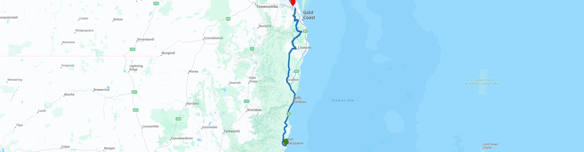
Starting point: Port Macquarie, Hotel Waters Edge
End point: Brisbane, Hotel Gloria Springwood
The route has been created for TomTom, Garmin and MyRoute-app Navigation users.
ATTENTION: DRIVE LEFT!
 Share this route


Animation

Verdict


Duration
8h 1m

Mode of travel
Car or motorcycle

Distance
592.38 km

Countries

 RouteXpert Review
 Brisbane started as a penal colony in 1824 and is named after Sir Thomas Brisbane, then Governor of New South Wales. When Queensland was declared a separate state in 1859, Brisbane was chosen as its capital. Until World War II, the city developed slowly. During World War II, the allied headquarters of General Douglas MacArthur was located in Brisbane and the city played a central role in the battle in the Southwest Pacific. The government of the Dutch East Indies also stayed in Brisbane during the Japanese occupation from 1942 to 1945. Brisbane organized the Commonwealth Games in 1982 and the World Exhibition was held in 1988. From that period, the city has experienced rapid growth and has grown into the current metropolis. In January of 2011, a major flood hit Brisbane. Brisbane has a typical subtropical climate with hot, humid summers and mild, dry winters. From late spring to early autumn, Brisbane is regularly hit by heavy thunderstorms, sometimes accompanied by large hailstones and strong gusts of wind.
The highest recorded temperature in the city was 43.2 ° C on January 26, 1940, the lowest temperature was 2.3 ° C and was measured on July 12, 1894 and July 2, 1896. With a rainfall of 465 mm, January 21, 1887 was the wettest day in Brisbane history.
You can refuel and go shopping in Port Macquarie before you go on the Pacific Highway, so that your tank is full and you can stop for a picnic at one of the many options along the way. Soon after leaving Port Macquarie, turn onto the Old Pacific Highway and then onto the Pacific Highway. You keep following this for about 200 KM to Grafton. On the way you pass the town of Coffs Harbor, where you can stop at the "Big Banana Fun Park" to eat and / or drink. Coffs Harbor, also known as Coffs for short, is a coastal town in northern New South Wales. It is a popular holiday destination for tourists. This is mainly because it is far enough north to have a semi-tropical climate but still relatively close to Sydney and Brisbane.
In Grafton, this is a town in the Northern Rivers region of the Australian state of New South Wales, you also have the option to refuel and eat along the route. You can choose from: McDonalds, Hungry Jacks & Driven Cafe. As mentioned, you leave the Pacific Highway to drive to the town of Casino via the Summerland Way. The Summerland Way is a 199-kilometer state route, designated B91. This runs from Grafton to the border between NSW and Queensland. Casino is a city in the Northern Rivers region of New South Wales. It sits on the banks of the Richmond River and is at the junction of the Bruxner Highway and the Summerland Way. Again, plenty of opportunities to take a break.
Then you go through Rock Valley and the Kyogle Road Lookout, with a lovely picnic area with a view and Gas station & Sphinx Rock Cafe, to Natural Bridge. You have now arrived in Queensland.
Natural Bridge is located in the western part of Springbrook National Park, part of the Gondwana Rainforests of Australia World Heritage Area. The Natural Bridge section of the park has a picturesque rock formation formed by the power of the waterfall above the basalt cave. It is easily accessible from the Nerang-Murwillumbah Road car park. Follow the (easy) one kilometer circuit (walk clockwise) and descend through the ancient Gondwana rainforest to the Natural Bridge rock arch. Heap of pine trees emerging from the surrounding forest are living relics from the Jurassic era, 180 million years ago. During the day you will spot birds of paradise, green catfish, wompoo fruit pigeons and also rare and endangered species such as the cascade tree frog, the tusk frog, the sooty owl and the koala. Then you go to the Hinze Dam which is 30 KM away.
The Hinze Dam is a rock and earth-filled dike dam with a non-gated spillway over the Nerang River in the Gold Coast hinterland in South East, Queensland. The main purpose of the dam is the drinking water supply of the Gold Coast region. The reservoir is called Advancetown Lake.
After Hinze Dam there is another stop in North Tamborine, this is a district of Tamborine Mountain in South East Queensland. It is 40 km from the Gold Coast. You can refuel here and stop at the Curtis Falls Cafe to have a drink and possibly walk to the waterfall to take some photos. What you should definitely do is the Tamborine forest skywalk!
This exciting hike gives you a unique and exciting way to explore the beautiful rainforest canopies. Located in a magical 30 acre private rainforest next to the crystal clear rock pools of Cedar Creek on Mount Tamborine. The walk takes about 45 minutes at a leisurely pace, pausing to view the many sights and information along the way. The entire hike is 1.5km in total and is a combination of forest floor paths, 300m high-tech steel bridges through the highest points of the upper canopy and a 40m long cantilever bridge that juts out a breathtaking 30m above the creek and the rainforest below.
After this breathtaking hike it is time to drive to the end of this route. You will pass Windaroo, this is a suburb of Logan City. Then refuel and check in at the hotel.
This 4-star rated route covers both the Old Pacific Highway and the Pacific Highway, then through nature reserves and some small towns where you can stop for refreshments.
General info:
New South Wales is a federal state of Australia with Sydney as its capital, and is often shortened to NSW. The three main cities are, from north to south, Newcastle, Sydney and Wollongong, all of which are on the coast. Other towns include Albury, Broken Hill, Dubbo, Tamworth, Armidale, Lismore, Nowra and Coffs Harbor.
The state is located on the east coast of the continent, north of the state of Victoria and south of the state of Queensland. In the west it borders South Australia. The coast borders the Tasman Sea. New South Wales has two federal enclaves: the Australian Capital Territory (ACT) and the Jervis Bay Territory.
New South Wales can be physically divided into four parts:
A narrow coastal strip, with a climate whose temperature ranges from moderate on the far south coast to subtropical on the Queensland border.
The mountainous regions of the Great Divide Mountains and surrounding highlands such as the Southern Highlands, Central Tablelands and New England regions. Although the mountain walls are not very steep, many mountain peaks rise above 1000 meters, of which Mount Kosciuszko as the highest peak reaches 2229 meters.
The agricultural plains, which make up much of the area of the state. These areas are much less populated than the coast. This part includes the Riverina region.
The dry, desert-like plains in the far northwest of the state, unsuitable for settlements of any size.
It is the oldest colony of the former Australian colonies of the United Kingdom. The colony was founded in 1788 and originally included much more of the Australian mainland. At that time, the western half of the colony was called New Holland and the eastern half was called New South Wales. New Holland was controlled from Sydney.
During the nineteenth century, large areas were separated around the British colonies of Van Diemen's Land (Tasmania) (1825), Victoria (1851), Queensland (1859) and South Australia (1836) (which at the time also included the Northern Territory) to shape. These colonies and Western Australia voted in 1901 to continue as the Commonwealth of Australia.
Tourist attractions in the state include; The Blue Mountains, west of Sydney, a national park that includes the Three Sisters rock formation; The Hunter Valley, 150 km north of Sydney, Australia's oldest wine region. The Snowy Mountains, on the border with Victoria, a popular ski area, and the capital, Sydney.


 Links
Links  Usage
Usage Want to download this route?
You can download the route for free without MyRoute-app account. To do so, open the route and click 'save as'. Want to edit this route?
No problem, start by opening the route. Follow the tutorial and create your personal MyRoute-app account. After registration, your trial starts automatically.  Disclaimer
Use of this GPS route is at your own expense and risk. The route has been carefully composed and checked by a MyRoute-app accredited RouteXpert for use on TomTom, Garmin and MyRoute-app Navigation.
Changes may nevertheless have occurred due to changed circumstances, road diversions or seasonal closures. We therefore recommend checking each route before use.
Preferably use the route track in your navigation system. More information about the use of MyRoute-app can be found on the website under 'Community' or 'Academy'.