TTT 1993 01 De wegen van prins carnaval

This route was brought to you by:
RouteXpert Hans van de Ven (Mr.MRA)
Last edit: 19-05-2020
 Route Summary
 The 173 ANWB Promoter TankTasTochten (TTT) were scanned by Henry ten Dam and signed by Leon Stolk in Mapsource and later placed as a Track in a .gpx file. These have been made available with the approval of ANWB Promotor via the website of MrGPS so that everyone can enjoy it. The 1st TTT is from 1992, so the route may be slightly different from the original.
I checked all route points and placed them neatly on the road. Also, if necessary, I have put the start point and end point of the route a bit further apart to avoid navigating directly to the end point and I have added the POI files from the start and end point just like a possible stopping point.
Finally, I created the route for TomTom, Garmin and MyRoute-app Navigation users.
With thanks to Henry, Leon, MrGPS and Promoter
 Share this route


Animation

Verdict


Duration
6h 15m

Mode of travel
Car or motorcycle

Distance
272.38 km

Countries


 RouteXpert Review
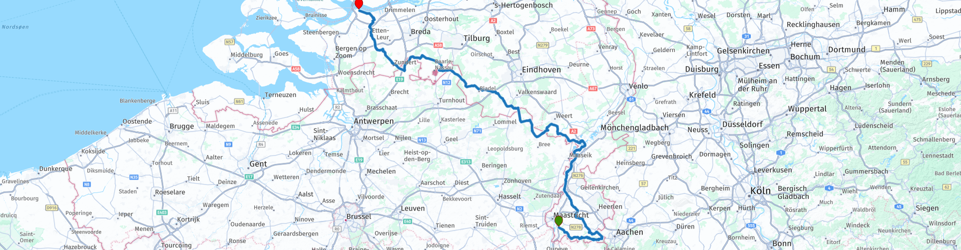
 We drive via the Limburg hills to Vaals and then drive up to Midden-Limburg, where you can stop at Urpunt at junction 15 for a snack. We continue our journey and just before Roermond we turn left towards Altweerterheide, where we cross the border with Belgium and then cross it again at Hamont-Achel.
Through all these beautiful roads we drive through the Borkelsche Heide, where you can stop for a pancake lunch at the Family Suykerbuyck. You can see this restaurant at route point 43.
We continue via the Brabantse Kempen to Zundert, where you can once again stop for another snack. After the coffee the final stage of this TTT follows to Willemstad where you end the trip at "Het Wapen van Willemstad".
Because I have not driven this route (yet) myself, this route gets 3 stars.
Route details:
You pass through the places below (Namur as these are called with carnival).
Urmond: The Water Ratter
Chaam: Beanspikkerslaand
Weert: Rogstaekersstad (although the name Wieërt is used more)
Valkenburg: 't Bokkeriek
Zundert: Banaon fire extinguisher (formerly Maonblusserslaand)
Willemstad: Kakeldonk
Wijlre: 't Puimeriek
Eersel: Neighborhood hole
Rucphen: Kraaierijk
Valkenswaard: Striepersgat (A strieper is a cigar maker In Valkenswaard many cigar factories existed in the 19th century)


 Usage
Usage Want to download this route?
You can download the route for free without MyRoute-app account. To do so, open the route and click 'save as'. Want to edit this route?
No problem, start by opening the route. Follow the tutorial and create your personal MyRoute-app account. After registration, your trial starts automatically.  Disclaimer
Use of this GPS route is at your own expense and risk. The route has been carefully composed and checked by a MyRoute-app accredited RouteXpert for use on TomTom, Garmin and MyRoute-app Navigation.
Changes may nevertheless have occurred due to changed circumstances, road diversions or seasonal closures. We therefore recommend checking each route before use.
Preferably use the route track in your navigation system. More information about the use of MyRoute-app can be found on the website under 'Community' or 'Academy'.