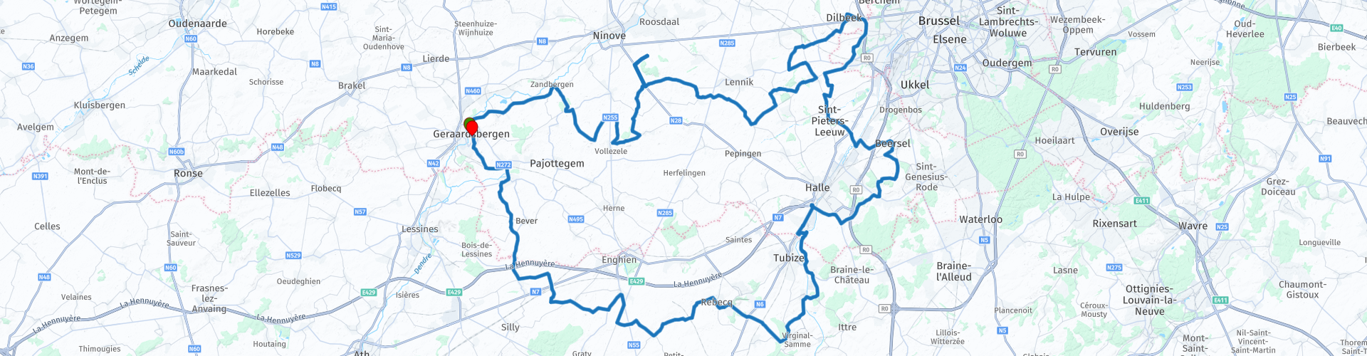
Roundtrip from Geraardsbergen through the Pajottenland and the Zenne valley

This route was brought to you by:
RouteXpert Catherine De Groote RouteXpert
Last edit: 08-01-2021
 Route Summary
 Characteristic of the region is the slightly hilly and rural character with winding narrow lanes. It largely concerns the southwestern Brabant hilly landscape between the rivers Dender and Zenne. It is also known as the Tuscany of the Low Countries.
The way back goes through the Zenne Valley, an area with rolling valleys and numerous streams.
 Share this route


Animation

Verdict


Duration
4h 22m

Mode of travel
Car or motorcycle

Distance
141.64 km

Countries

 RouteXpert Review
 Just outside Geraardsbergen you pass the provincial domain De Gavers (RP 3). The domain is located around a 20-hectare pond. It offers space for walking or cycling, and it has a beach and a sports and leisure complex and some terraces and cafeterias. In addition, there are also a camping site, hiker's huts, bungalows and a youth hostel.
In the vast landscape around Vollezele you pass the artwork in sheet steel by Koenraad Tinel 'The kidnapping of Europe' (RP 6). The Phoenician princess Europa is represented as an ancient Venus figure. She is sitting on the back of a running bull to depict the god Zeus. The statue, eight meters high and almost nine meters long, comes into its own here in the barren meadow.
If you want to relax for a coffee or a drink, this is possible in Café De Vrede in Gooik (RP 13).
The ride continues along the Castle of Gaasbeek (RP 16) - The Castle of Gaasbeek is an original medieval castle, now a national museum, located in Gaasbeek, a part of Lennik.
The castle is surrounded by 50 hectares of walking park and forest. It contains several historic buildings. To the east of the castle is an oval, brick tea house with sandstone frames on a slope. The domain also includes three large ponds. In the valley, near the ponds, there is a baroque Saint Gertrude chapel (protected building). Some of the trees in the park are more than three hundred years old. Open from April to August. Mon: Closed. Tue - Sun: 10am - 6pm. Open on public holidays. Entry price: 10 euros.
A few kilometers further you arrive at the Castle of Dilbeek (RP 22) - The castle de Viron in Dilbeek is a protected monument that was built in 1862 for the de Viron family. In 1923 the municipality bought the castle and it was used as a town hall. Today the castle mainly has a ceremonial function. Only to be visited with a guide.
You are now approaching the capital Brussels, the habitation is getting more intense, but you also continue to drive along smaller roads as much as possible, which is also not so bad for traffic.
A little further you come back into an open landscape. On the Puttenberg in Sint-Pieters-Leeuw is the 'Boom van Witse' (RP 26) - a summer lime tree - from the TV series of the same name. The tree combines the rural of the Pajottenland with the urban of the big city.
As a result of the series, the tree has become a tourist attraction for the region. In 2010, the Witseboom, together with the 28-meter area around the tree, was protected as a monument because of its artistic, socio-cultural, historical and folkloric value.
If you want to take a break to have a drink, you can do so in Brasserie In 't Vagevuur (RP 28). A little further you also have a nice view of Brussels (RP 29).
Two more castles await you, the next of which is the Castle of Coloma (RP 30). The Domain Coloma is a park and castle domain in the Belgian municipality of Sint-Pieters-Leeuw. On the domain are the castle of Coloma and the rose garden. The rose garden is of absolute world level. That is undoubtedly the domain's greatest asset. More than 3,000 different rose varieties from all over the world grow here. The rose garden is open all year round from Tuesday to Sunday from sunrise to sunset. Also on public holidays. The recommended visit period is from June to early October.
You cross the Ring (RO) of Brussels and arrive at the last castle along this ride, namely the Castle of Beersel (RP 31). The castle of Beersel, a moated castle, is one of the few, well-preserved examples of medieval martial architecture in our country. It is still there as it looked at the end of the 15th century. Over the centuries, this airlock had a very eventful history. As a visitor you immediately experience how people lived in a medieval, fortified castle. In 1999, the municipal council of Beersel took over the management of the castle. The castle has been renovated in several phases since 2003.
Beersel Castle can usually be visited from Tuesday to Sunday. The castle is closed during the winter months, December, January and February. In March and November: only open on Saturday and Sunday from 11 am to 5 pm
Just like the Pajottenland, the Zenne valley you now cross has a lot to offer: the typical, the unique lambic beers. It is also part of the Green Belt and is located between Brussels and the language border.
Today it is best known for its regional product Lambiek (beer) and the derived drinks Faro, Kriek and especially Geuze.
The brewing of lambic differs from the brewing of other beers by the use of wild mixed yeasts. The environment plays an essential role. Lambic brewers, unlike other brewers, do not themselves add yeast to their brew. During a cold winter night they spontaneously let the wort 'graft' by micro-organisms that are in the air of the Zenne Valley and the Pajottenland.
In Quenast you drive past a quarry (RP 39). This quarry is the largest open-air quarry in Europe with an area of 140 hectares, and in some places a depth of 125 m. Porphyry has been mined here since the 17th century. The rock that is mined is very hard and traditionally served to make the famous Belgian cobblestones.
Visits by reservation only - Groups of 10 to 40 people. - For the classic visit: € 1 / pers. with a flat rate of € 10 (- of 10 people). For the long visit: € 2.50 / pers. with a flat rate of € 20 (- of 8 people). Duration: Minimum1: 00 - Maximum1: 30
When you cross the A8 motorway you will return to the Flemish Ardennes. About 15 km and you are back in Geraardsbergen.
The gently sloping landscape of the Pajottenland and the Senne Valley determines the character of the region. Nature, landscape, agriculture, heritage and culture go together intensely here. You can discover all this in this ride along winding quiet roads. That is why this route is definitely worth 4 stars.


 Links
Links  Usage
Usage Want to download this route?
You can download the route for free without MyRoute-app account. To do so, open the route and click 'save as'. Want to edit this route?
No problem, start by opening the route. Follow the tutorial and create your personal MyRoute-app account. After registration, your trial starts automatically.  Disclaimer
Use of this GPS route is at your own expense and risk. The route has been carefully composed and checked by a MyRoute-app accredited RouteXpert for use on TomTom, Garmin and MyRoute-app Navigation.
Changes may nevertheless have occurred due to changed circumstances, road diversions or seasonal closures. We therefore recommend checking each route before use.
Preferably use the route track in your navigation system. More information about the use of MyRoute-app can be found on the website under 'Community' or 'Academy'.

Wallonia
About this region
The Walloon Region (French: Région wallonne [ʁeʒjɔ̃ walɔn]; German: Wallonische Region; Dutch: Waals gewest), usually simply referred to as Wallonia (; French: Wallonie [walɔni]; Walloon: Waloneye; German: Wallonien [vaˈloːni̯ən] (listen) or Wallonie [valoˈniː]; Dutch: Wallonië [ʋɑˈloːnijə] (listen)), is one of the three Regions of Belgium—alongside the Flemish Region and the Brussels-Capital Region.Covering the southern portion of the country, Wallonia is primarily French-speaking, and accounts for 55% of Belgium's territory, but only a third of its population. The Walloon Region was not merged with the French Community of Belgium, which is the political entity responsible for matters related mainly to culture and education, because the French Community of Belgium encompasses both Wallonia and the bilingual Brussels-Capital Region.
There is a German-speaking minority in eastern Wallonia, resulting from the annexation of three cantons previously part of the German Empire at the conclusion of World War I. This community represents less than 1% of the Belgian population. It forms the German-speaking Community of Belgium, which has its own government and parliament for culture-related issues.
During the industrial revolution, Wallonia was second only to the United Kingdom in industrialization, capitalizing on its extensive deposits of coal and iron. This brought the region wealth, and from the beginning of the 19th to the middle of the 20th century, Wallonia was the more prosperous half of Belgium. Since World War II, the importance of heavy industry has greatly diminished, and the Flemish Region has exceeded Wallonia in wealth as Wallonia has declined economically. Wallonia now suffers from high unemployment and has a significantly lower GDP per capita than Flanders. The economic inequalities and linguistic divide between the two are major sources of political conflicts in Belgium and a major factor in Flemish separatism.
The capital of Wallonia is Namur, and the most populous city is Charleroi. Most of Wallonia's major cities and two-thirds of its population lie along the east-west aligned Sambre and Meuse valley, the former industrial backbone of Belgium. To the north of this valley, Wallonia lies on the Central Belgian Plateau, which, like Flanders, is a relatively flat and agriculturally fertile area. The south and southeast of Wallonia is made up of the Ardennes, an expanse of forested highland that is less densely populated.
Wallonia borders Flanders and the Netherlands (the province of Limburg) in the north, France (Grand Est and Hauts-de-France) to the south and west, and Germany (North Rhine-Westphalia and Rhineland-Palatinate) and Luxembourg (Capellen, Clervaux, Esch-sur-Alzette, Redange and Wiltz) to the east. Wallonia has been a member of the Organisation Internationale de la Francophonie since 1980.
Read more on Wikipedia
There is a German-speaking minority in eastern Wallonia, resulting from the annexation of three cantons previously part of the German Empire at the conclusion of World War I. This community represents less than 1% of the Belgian population. It forms the German-speaking Community of Belgium, which has its own government and parliament for culture-related issues.
During the industrial revolution, Wallonia was second only to the United Kingdom in industrialization, capitalizing on its extensive deposits of coal and iron. This brought the region wealth, and from the beginning of the 19th to the middle of the 20th century, Wallonia was the more prosperous half of Belgium. Since World War II, the importance of heavy industry has greatly diminished, and the Flemish Region has exceeded Wallonia in wealth as Wallonia has declined economically. Wallonia now suffers from high unemployment and has a significantly lower GDP per capita than Flanders. The economic inequalities and linguistic divide between the two are major sources of political conflicts in Belgium and a major factor in Flemish separatism.
The capital of Wallonia is Namur, and the most populous city is Charleroi. Most of Wallonia's major cities and two-thirds of its population lie along the east-west aligned Sambre and Meuse valley, the former industrial backbone of Belgium. To the north of this valley, Wallonia lies on the Central Belgian Plateau, which, like Flanders, is a relatively flat and agriculturally fertile area. The south and southeast of Wallonia is made up of the Ardennes, an expanse of forested highland that is less densely populated.
Wallonia borders Flanders and the Netherlands (the province of Limburg) in the north, France (Grand Est and Hauts-de-France) to the south and west, and Germany (North Rhine-Westphalia and Rhineland-Palatinate) and Luxembourg (Capellen, Clervaux, Esch-sur-Alzette, Redange and Wiltz) to the east. Wallonia has been a member of the Organisation Internationale de la Francophonie since 1980.
View region
 Statistics
  80
80Amount of RX reviews (Wallonia)
 22207
22207Amount of visitors (Wallonia)
 18632
18632Amount of downloads (Wallonia)
 Route Collections in this region
 The 10 most beautiful car and motorcycle routes in Limburg
Limburg, who thinks of Limburg, thinks of flan, coal mines, marl and the hill country. The coal mines have been closed for almost 40 years, the last load of coal was brought up from the Oranje-Nassau coal mine in Heerlen on 31 December and, as they say, South Limburg was transformed from Black to Green and unfortunately there is still little left. view of this period.
But not only pie, marl and coal in Limburg, but also a very beautiful province to tour by car or motorcycle and enjoy all the beauty that the province of Limburg has to offer. For this, the MyRoute app RouteXpert has put together a Top 10 of Car and Motorcycle routes for you.
All routes in this collection have been checked and made equal for TomTom, Garmin and MyRoute-app Navigation by a MyRoute-app RouteXpert.
If you think, I have a very nice route that should certainly not be missing from this collection, send it to:
email: routeexpert@myrouteapp.com
Subject: New Route for the Top 10 collection Province of Limburg composed by Hans van de Ven.
The route will then be reviewed and then added to the Top 10.
To make the Top 10 also the Top 10, 1 route will have to disappear from the Top 10, you can indicate this when submitting the new route.
Have fun with this collection and while driving one of these routes. Enjoy all the beauty that the Netherlands and in particular the province of Limburg has to offer. Click on “View route” to read the review of the chosen route.
I would like to hear your findings about the route(s).
View Route Collection
Top 5 Car and Motorcycle Routes in the Eifel
The Eifel is the eastern part of the medium plateau Eifel-Ardennes. It is located north of the Moselle and west of the Rhine. The largest part is in Germany, a small part is in Belgium, in the East Cantons. The German part of Eifel is located in the federal states of North Rhine-Westphalia and Rhineland-Palatinate. The highest point is the Hohe Acht with 747 meters.
Several chains can be distinguished in the Eifel:
The northernmost part is called the Nordeifel, which in Belgium connects to the High Fens;
To the east of this is the Ahrgebirge, this part is located north of the Ahr in the Ahrweiler district;
South of the Ahr is the Hohe Eifel (or Hocheifel), of which the Hohe Acht (747 m) is the highest point, and also the highest point in the entire Eifel region;
To the west, near the Belgian border, the hills are known as Schneifel, part of the wider Snow Eifel area with peaks reaching up to 698 metres;
South and east of the Hohe Eifel is the Volcano-Eifel, a volcanic area with many crater lakes (Maare).
The southern part of the Eifel is less high. The area is bisected by streams and rivers running southwards. These streams flow into the Moselle. The largest of these rivers is the Kyll; the hills around this river are known as the Kyllwald;
In the south, the Eifel ends in the Voreifel.
In the north of the Eifel there are some large reservoirs. The largest of these is the reservoir in the Roer that was created by the construction of the Roerdal dam.
The Nürburgring is also located in the Eifel, a well-known car circuit for Formula 1 races, among other things. Since 2004, part of the north of the Eifel has become the Eifel National Park. This National Park falls entirely within the German-Belgian nature park High Fens-Eifel. Another part of the Eifel falls within the South Eifel Nature Park.
Well-known throughout the Netherlands and Belgium by car and motorcyclists, so reason enough for the MyRoute app RouteXpert to compile a Top 5 of Car and Motorbike routes for you.
All routes in this collection have been checked and made equal for TomTom, Garmin and MyRoute-app Navigation by a MyRoute-app RouteXpert.
If you think, I have a very nice route that should certainly not be missing from this collection, send it to:
email: routeexpert@myrouteapp.com
Subject: New Route for the Top 5 collection Eifel composed by Hans van de Ven.
The route will then be reviewed and then added to the Top 5. To make the Top 5 also the Top 5, 1 route will have to disappear from the Top 5, you can indicate this when submitting the new route.
Have fun with this collection and while driving one of these routes. Enjoy all the beauty that the Eifel has to offer. Click on “View route” to read the review of the chosen route.
I would like to hear your findings about the route(s).
View Route Collection