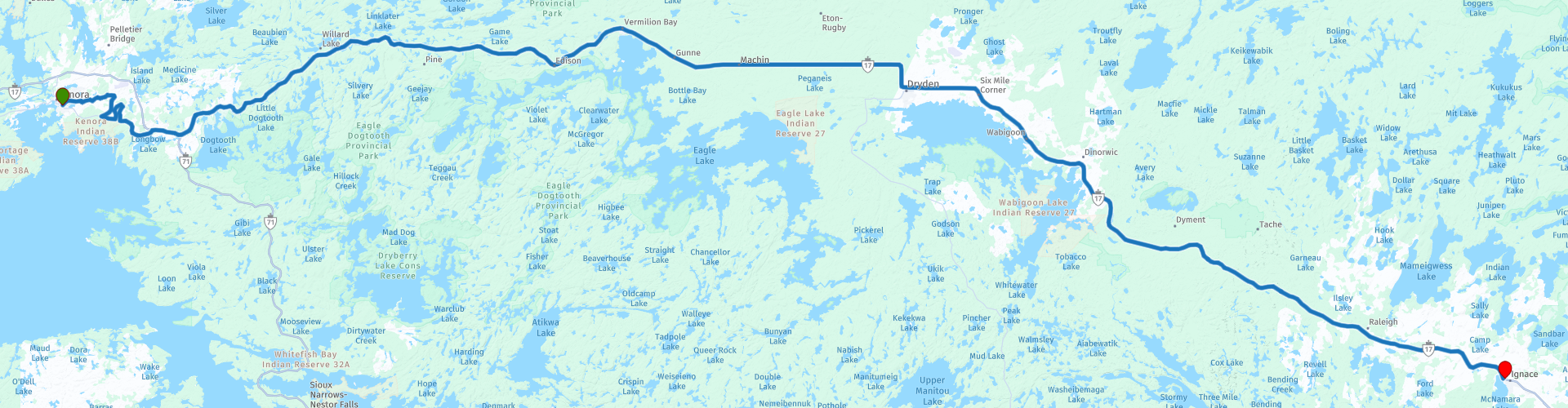
Day 13 TCH Kenora to Ignace

This route was brought to you by:
RouteXpert René Plücken (MRA Master)
Last edit: 12-02-2021
 Route Summary
 This is part 13 that runs from Kenora to Ignace.
The Trans Canada Highway passes through all the southern provinces of the country. The route can be driven in different ways. There are namely in various alternative routes that also belong to the TCH. The total distance is around 8,000 km. We not only drive the TCH, but will take the rural roads as much as possible, because only highway driving is too boring and Canada has many beautiful roads through its beautiful landscape.
You drive through all provinces and through very varied and scenic landscapes, from the Rockies in the West, the Central Prairies to the Eastern Maritimes and the Northern Forest.
The riding season is generally April through October with longer seasons on the west coast and southern Ontario.
Provide good all season clothing or bring rain gear, depending on the province and the season the weather can change and you may be surprised by a rain or even a snow or hail shower, so be prepared.
In Canada the metric system is used, so speeds are indicated in Km / h. A helmet requirement (DOT approved) applies throughout Canada.
You will see many wildlife throughout Canada. your similar animals from province to province, such as deer, buffalos, moose, caribou, wolves, pumas, bears, mountain goats, sheep, lynx, coyotes, foxes, raccoons, badgers, various rodents and all kinds of birds.
Even if it is very tempting to stop for a photo, don't do it, it can be very dangerous.
 Share this route


Animation

Verdict


Duration
3h 21m

Mode of travel
Car or motorcycle

Distance
252.34 km

Countries

 RouteXpert Review
 We leave Kenora in a northerly direction to drive via the Gould Road (RP2) and Transmitter road (RP3) to the junction with the Trans Canada Highway. We take this road because this is a beautiful winding provincial road along a number of small lake and with rocks, trees and hills.
We also drive on a nice narrow winding road around Hilly lake (RP5). Please note, because some parts are unpaved. Between the trees you can occasionally catch a glimpse of the lake.
After this diversion we drive back on the Trans Canada Highway, the road is well paved, two lanes wide and winds through a beautiful landscape with hills, forests, many lakes and rivers. There are several options along the way to stop and enjoy the panorama and to take a photo.
You pass a few small settlements, one of which is Fort Vermillion (RP14) where you can take a break and have a drink in one of the restaurants. The other town is Dreyden (RP16) where you can have lunch.
There are no sights along the route to stop a bit longer. But nevertheless this ride is enjoyable because of the beautiful Trans Canada Highway through a beautiful and varied landscape. That is why I rate this route with 3 *** Stars.


 Links
Links  Usage
Usage Want to download this route?
You can download the route for free without MyRoute-app account. To do so, open the route and click 'save as'. Want to edit this route?
No problem, start by opening the route. Follow the tutorial and create your personal MyRoute-app account. After registration, your trial starts automatically.  Disclaimer
Use of this GPS route is at your own expense and risk. The route has been carefully composed and checked by a MyRoute-app accredited RouteXpert for use on TomTom, Garmin and MyRoute-app Navigation.
Changes may nevertheless have occurred due to changed circumstances, road diversions or seasonal closures. We therefore recommend checking each route before use.
Preferably use the route track in your navigation system. More information about the use of MyRoute-app can be found on the website under 'Community' or 'Academy'.