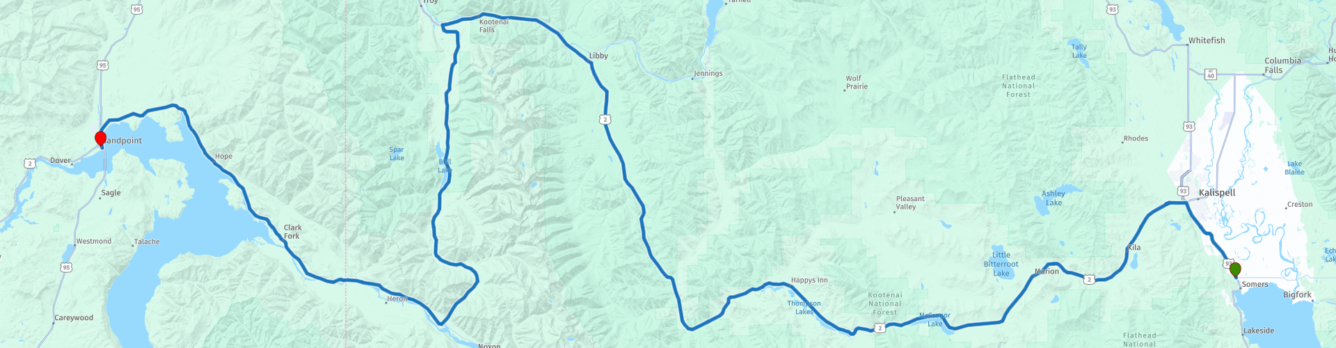
D08 Kalispell Sandpoint

This route was brought to you by:
RouteXpert Hans van de Ven (Mr.MRA)
Last edit: 02-05-2021
 Route Summary
 The roads are very good, the surroundings beautiful, enjoy the many lakes along the way and you should definitely make a stop along Lake Oreille.
Starting point: Best Western Plus Flathead Lake Inn and Suites
End point: Best Western Edgewater Resort
The route has been made the same for TomTom, Garmin and MyRoute-app Navigation users.
Thanks to Richard & Lisa for the information!
 Share this route


Animation

Verdict


Duration
4h 51m

Mode of travel
Car or motorcycle

Distance
308.59 km

Countries

 RouteXpert Review
 Sandpoint is a small town with approximately 7,000 inhabitants and is located on the nearly seventy-kilometer-long Lake Pend Oreille. It is a holiday destination with a lively arts community, a full event calendar and many restaurants, hotels and shops.
A market takes place twice a week in Farmin Park from May to October. Fresh products are sold, but also handmade items and flowers. There is also live music. Another market is the Cedar Street Bridge Public Market. This market is the only market in the US that takes place on a bridge. At this market you can buy clothing and jewelry, among other things.
In this 4-star route you will drive on beautiful good roads, and through beautiful surroundings, the Sinclair Pass, the Glacier National Park with the many lakes where you will certainly stop 1 or more times.
History:
Before Sandpoint officially became a city in 1907, members of the Kalispel tribe lived there. Their habitat extended in a northerly direction from the Priest and Pend Oreille Lakes to the Pend Oreille River in Canada. In the east, the state of Montana formed the border. The first settlers came with the construction of the Northern Pacific Railroad at the end of the nineteenth century. On the east side of Sand Creek, opposite the current Sandpoint, a small settlement was created: Pend Oreille. The Great Northern Railroad bought a large piece of land along the west bank of Sand Creek, and built a village here that would later develop into the current Sandpoint. Mining and forestry became important sources of income. Farmers went their own way on deforested land. Because the growing season in northern Idaho is very short, they did not grow crops, but used the so-called 'stump ranches' mainly for growing grass. The hay that was 'harvested' went to the horses that were used in the wood industry. Nowadays the emphasis is more on tourism. In the winter months, the Schweitzer Basin ski area is a big draw and in the summer tourists come because of the large (water) recreation offer.


 Links
Links  Usage
Usage Want to download this route?
You can download the route for free without MyRoute-app account. To do so, open the route and click 'save as'. Want to edit this route?
No problem, start by opening the route. Follow the tutorial and create your personal MyRoute-app account. After registration, your trial starts automatically.  Disclaimer
Use of this GPS route is at your own expense and risk. The route has been carefully composed and checked by a MyRoute-app accredited RouteXpert for use on TomTom, Garmin and MyRoute-app Navigation.
Changes may nevertheless have occurred due to changed circumstances, road diversions or seasonal closures. We therefore recommend checking each route before use.
Preferably use the route track in your navigation system. More information about the use of MyRoute-app can be found on the website under 'Community' or 'Academy'.

Idaho
About this region
Idaho is a state in the Pacific Northwest region of the United States. It borders the state of Montana to the east and northeast, Wyoming to the east, Nevada and Utah to the south, and Washington and Oregon to the west. To the north, it shares a small portion of the Canadian border with the province of British Columbia. With a population of approximately 1.8 million and an area of 83,570 square miles (216,400 km2), Idaho is the 14th largest, the 13th least populous and the 7th least densely populated of the 50 U.S. states. The state's capital and largest city is Boise.
For thousands of years Idaho has been inhabited by Native American peoples. In the early 19th century, Idaho was considered part of the Oregon Country, an area disputed between the United States and the British Empire. It officially became U.S. territory with the signing of the Oregon Treaty of 1846, but a separate Idaho Territory was not organized until 1863, instead being included for periods in Oregon Territory and Washington Territory. Idaho was eventually admitted to the Union on July 3, 1890, becoming the 43rd state.
Forming part of the Pacific Northwest (and the associated Cascadia bioregion), Idaho is divided into several distinct geographic and climatic regions. The state's north, the relatively isolated Idaho Panhandle, is closely linked with Eastern Washington with which it shares the Pacific Time Zone—the rest of the state uses the Mountain Time Zone. The state's south includes the Snake River Plain (which has most of the population and agricultural land). The state's southeast incorporates part of the Great Basin. Idaho is quite mountainous, and contains several stretches of the Rocky Mountains. The United States Forest Service holds about 38% of Idaho's land, the highest proportion of any state.Industries significant for the state economy include manufacturing, agriculture, mining, forestry, and tourism. A number of science and technology firms are either headquartered in Idaho or have factories there, and the state also contains the Idaho National Laboratory, which is the country's largest Department of Energy facility. Idaho's agricultural sector supplies many products, but the state is best known for its potato crop, which comprises around one-third of the nationwide yield. The official state nickname is the "Gem State", which references Idaho's natural beauty.
Read more on Wikipedia
For thousands of years Idaho has been inhabited by Native American peoples. In the early 19th century, Idaho was considered part of the Oregon Country, an area disputed between the United States and the British Empire. It officially became U.S. territory with the signing of the Oregon Treaty of 1846, but a separate Idaho Territory was not organized until 1863, instead being included for periods in Oregon Territory and Washington Territory. Idaho was eventually admitted to the Union on July 3, 1890, becoming the 43rd state.
Forming part of the Pacific Northwest (and the associated Cascadia bioregion), Idaho is divided into several distinct geographic and climatic regions. The state's north, the relatively isolated Idaho Panhandle, is closely linked with Eastern Washington with which it shares the Pacific Time Zone—the rest of the state uses the Mountain Time Zone. The state's south includes the Snake River Plain (which has most of the population and agricultural land). The state's southeast incorporates part of the Great Basin. Idaho is quite mountainous, and contains several stretches of the Rocky Mountains. The United States Forest Service holds about 38% of Idaho's land, the highest proportion of any state.Industries significant for the state economy include manufacturing, agriculture, mining, forestry, and tourism. A number of science and technology firms are either headquartered in Idaho or have factories there, and the state also contains the Idaho National Laboratory, which is the country's largest Department of Energy facility. Idaho's agricultural sector supplies many products, but the state is best known for its potato crop, which comprises around one-third of the nationwide yield. The official state nickname is the "Gem State", which references Idaho's natural beauty.
View region
 Statistics
  7
7Amount of RX reviews (Idaho)
 9363
9363Amount of visitors (Idaho)
 93
93Amount of downloads (Idaho)
 Route Collections in this region
 Top car and motorcycle tour through Canada USA and the Rockies
Traveling by car or motorcycle through Canada, USA and the Rockies is a journey that you don't just make, so don't drive for 15 days and then return home. No, book a stay of several days in Vancouver, Jasper, Banff, Seattle and Port Alberni and again Vancouver to also visit several places of interest in these cities, so that this tour becomes an unforgettable tour that you can remember with pleasure.
Do not forget to arrange and pack the following items:
*This is only a summary and completely personal and may differ per person.
Take out travel insurance, +31 for numbers in GSM, (partially) take out gas, Health insurance coverage at destination?, Switch off electrical appliances, Lighting (time clock), Check passport validity, Antenna from radio/TV due to lightning, Residence address for those left behind, Remote control house alarm, Book Smart Parking.
Hand luggage:
Liquids in packaging of max. 100 ml, Liquids in hand luggage in transparent plastic bag.
For on the road:
Candy, Book, Earplugs, Country and road map(s), Directions, Maps in your navigation system
Money & Securities:
Bank card / giro card, Credit card (think pin code), Cash, Calculator for Internet banking, Medical insurance card, Travel insurance card.
Travel documents:
Passport, (International) Driver's License, Ticket(s), Reservation Tickets, Hotel Vouchers, Arrival/Departure Time, Check-in & Check-out Times, Valid Visa (ESTA), Travel Guide.
Clothing:
Underwear, Belt, Shirts/ T-shirts, Shorts, Long pants, Shoes, Socks, Swim trunks, Towel, Slippers.
Personal stuff:
Watch, House Keys, Wallet, Sunglasses.
Toiletries:
Deodorant, Shower gel / Soap, Comb / brush, Shaving equipment, Shampoo, Toothbrush, Toothpaste, Sanitary pads
Health & Medicine:
Own medicines, Insect repellent, Cold sore ointment, Ointment for insect bites, Sunscreen, Norit, Paracetamol, Suction cup for insect bites, First aid bag.
Miscellaneous:
Travel bag / waist bag, Leatherman (= checked luggage), Pen or pencil, Headlamp, Lighter, Tools & Electronics, Mobile phone & charger, Photo/video camera & charger, Memory card(s), World plug / adapter, Ipod & charger, Adapter cable Ipod, Headphones, iPad & charger, Navigation & charger/plug, Plug socket, Fuelpack battery.
Engine (accessories):
Helmet, Motorcycle clothing, Motorcycle boots, Chain lock / disc brake lock, Gloves, Bandana, Inner bags (plastic shopping bag), Insulation bag, Tension straps, Tie wraps, Rain suit, Rainaway.
Addresses:
Address list, Embassy telephone number, Telephone number to block (bank) card(s), Telephone number (airline tickets).
View Route Collection
The 10 most downloaded routes in the USA from RouteXpert Hans van de Ven
Hello and welcome to this collection of the Top 10 MyRoute app downloaded routes in USA.
There will be a great new event to be announced soon, where all these routes can be driven.
Download them all now and place them in a new "Top 10" folder, so that you always have them at hand.
If you are going to drive one of these routes in the meantime, track them with the MRA Mobile App or with MRA Navigation. Take some photos (moments) along the way as these will come in handy.
Create a travelogue of your Top 10 driven routes and add the recorded track to it.
There will also be some great prizes on offer, so keep an eye on the MRA-RouteXperts page and your mail.
The 10 routes are:
1. D13 Estes Park Denver
2. D03 Chadron Custer
3. D01 Pigeon Forge round trip through the Smokey Mountains
4. D08 Kalispell Sandpoint
5. D10 Colville Wenatchee
6. D09 Sandpoint Colville
7. D04 Custer Wall
8. D11 Wenatchee Seattle
9. D08 Cody Yellowstone NP
10.R13 San Francisco Monterey
View Route Collection