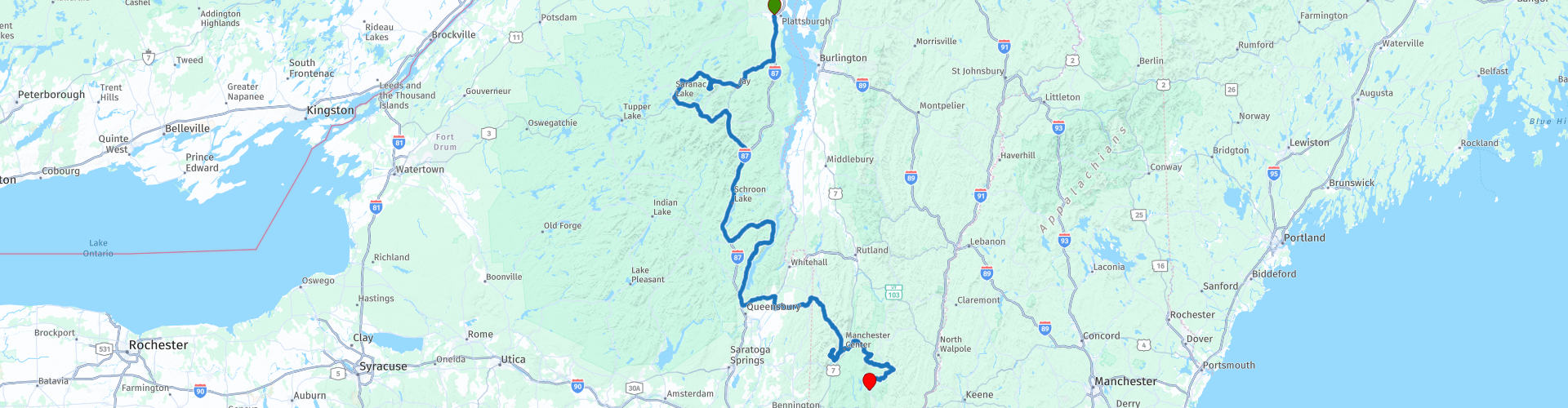
Plattsburgh to Dover

This route was brought to you by:
RouteXpert Paul Hedges - Adv RouteXpert
Last edit: 03-01-2020
 Route Summary
  Share this route


Animation

Verdict


Duration
7h 45m

Mode of travel
Car or motorcycle

Distance
477.59 km

Countries

 RouteXpert Review
 Leaving Plattsbugh on the tree lined Adironack Northway RT87 you are soon out of the city and into the countryside. Turning onto the 9N you follow the path of the Ausable River that appears on your left from behind the trees. The river is tour companion until you reach the town of Jay where you take a right onto the 86 and ride through the rural country views. Mountains start to appear on both sides as you progress.
As you arrive in Wilmington it is time for a break and french toast and coffee at the Country Bear Diner is a perfect place to sample both. Coming out of Wilmington on the 431 Whiteface Highway you travel through the forest on either side. To your right appears Santa’s Workshop, North Pole so drop in your letters if you have been good all year.
Follow the 431 and you will head towards Whiteface Mountain, $16 for motorbike and rider to ride to the top. Final part is on foot and takes you into the mountain itself. The views from the top of the 5th largest mountain in NY State are spectacular.
Once the visit to the top of the mountain is over it is back on the road heading north west on the 18a towards Franklin Falls Pond. Here you will see that the Americans have a different meaning to the word pond, it is about 10km long! As you arrive in Bloomingdale you turn onto the NY3 and things are now moving faster. The road is full of long bends as you make your way down to Saranac Lake.
Stopping next to Lake Flower to sample some frozen custard you can just spend time watching the boats on the lake.
The 86 is a free-flowing road with very little traffic that passes through small towns as you head to Lake Placid. Riding through Lake Placid is very different to the road getting there, the roads are narrower and filled with traffic. But with so much to look at it makes a change than the millions of trees you have just passed. More water to your left as you ride alongside Mirror Lake and then as you leave Lake Placid you can see on the hill the ski jumps that were used in the Olympic Games.
Riding along the NY-73 is just one easy bend after another constantly surrounded on both sides with more trees. Stop at Keene for a fuel stop and the NY-73 becomes the NY-73 Scenic, and riding through Keene Valley you will soon agree it is the right name. Closer to the mountains the sides of the road become rockier, but still the road bends one way and then the other until you re-join the Adironack Northway RT87. The next 30 miles pas very quickly after the slower back roads and soon you are turning off onto the 8 to ride alongside Brant Lake, the Graphite Mountain road has it all, long bends, mountains on the horizon, lakes to the left and right all while the ever present trees remind you that you are still in a wilderness. Time for some lunch so why not an old firehouse turned into a restaurant. And the Hague Firehouse restaurant is just that.
Heading south after lunch and you ride alongside Lake George for 30 miles, some sections are along the waters edge while others are back within the tree line. Plenty of opportunities to stop and take pictures along the way. As you continue south out of Lake George you take a right onto the 149 and the scenery changes as the trees withdraw and you are into farming country and the skyline opens. The 149 leads you all the way to Granville where there are plenty of places to pull in and get a drink. You can choose the big franchise restaurants or shop local and just use a local store.
The 30 from Granville to Manchester is a mix of farm and woodland but not many straight roads, more long sweeping curves to enjoy
Out of Manchester and it is onto Mount Equinox.
The Mount Equinox Skyline Drive is the longest privately-owned paved toll road in the USA, 5 miles to the top and about 1200 m above sea level. The road surface is great to rode and when you arrive at the top the $15 will feel like a bargain. WP49
Heading back through Manchester VT-30 is just more empty tree lined roads. Long sweeping bends take you all the way to Bondville. Turn right onto the Stratton Mountain Road as it makes its way over Mount Stratton. The Stratton Mountain Resort looks as though it has been from The Alps as it seems as though you are riding through Switzerland suddenly. WP53
Leaving Stratton, the final part of the day is a short ride down the VT-100 and into Dover to stay at the Big Bears Lodge


 Links
Links  Usage
Usage Want to download this route?
You can download the route for free without MyRoute-app account. To do so, open the route and click 'save as'. Want to edit this route?
No problem, start by opening the route. Follow the tutorial and create your personal MyRoute-app account. After registration, your trial starts automatically.  Disclaimer
Use of this GPS route is at your own expense and risk. The route has been carefully composed and checked by a MyRoute-app accredited RouteXpert for use on TomTom, Garmin and MyRoute-app Navigation.
Changes may nevertheless have occurred due to changed circumstances, road diversions or seasonal closures. We therefore recommend checking each route before use.
Preferably use the route track in your navigation system. More information about the use of MyRoute-app can be found on the website under 'Community' or 'Academy'.

Vermont
About this region
Vermont is a state in the New England region of the United States. It borders the states of Massachusetts to the south, New Hampshire to the east, and New York to the west, and the Canadian province of Quebec to the north. Vermont is the only state in New England that does not border the Atlantic Ocean. Vermont is the second-least-populated U.S. state after Wyoming and the sixth-smallest by area of the 50 U.S. states with a recorded population of 643,503 according to the 2020 U.S. census. The state capital is Montpelier, the least-populous state capital in the United States. The most-populous city, Burlington, is the least-populous city to be the most-populous city in a state.
For some 12,000 years, indigenous peoples inhabited this area. The historically competitive tribes of the Algonquian-speaking Abenaki and Iroquoian-speaking Mohawk were active in the area at the time of European encounter. During the 17th century, French colonists claimed the territory as part of the Kingdom of France's colony of New France. After the Kingdom of Great Britain began to settle colonies to the south along the Atlantic coast, the two nations competed in North America in addition to Europe. After being defeated in 1763 in the Seven Years' War, France ceded its territory east of the Mississippi River to Great Britain.
Thereafter, the nearby British Thirteen Colonies, especially the provinces of New Hampshire and New York, disputed the extent of the area called the New Hampshire Grants to the west of the Connecticut River, encompassing present-day Vermont. The provincial government of New York sold land grants to settlers in the region, which conflicted with earlier grants from the government of New Hampshire. The Green Mountain Boys militia protected the interests of the established New Hampshire land grant settlers against the newly arrived settlers with land titles granted by New York. Ultimately, a group of settlers with New Hampshire land grant titles established the Vermont Republic in 1777 as an independent state during the American Revolutionary War. The Vermont Republic abolished slavery before any of the other states.Vermont was admitted to the newly established United States as the fourteenth state in 1791. During the mid-19th century, Vermont was a strong source of abolitionist sentiment, although it was also tied to King Cotton through the development of textile mills in the region, which relied on southern cotton. It sent a significant contingent of soldiers to participate in the American Civil War.
The geography of the state is marked by the Green Mountains, which run north–south up the middle of the state, separating Lake Champlain and other valley terrain on the west from the Connecticut River valley that defines much of its eastern border. A majority of its terrain is forested with hardwoods and conifers, and a majority of its open land is devoted to agriculture. The state's climate is characterized by warm, humid summers and cold, snowy winters.
Vermont's economic activity of $34 billion in 2018 ranked last on the list of U.S. states and territories by GDP but 34th in GDP per capita. In 2000, the state legislature was the first to recognize civil unions for same-sex couples.
Read more on Wikipedia
For some 12,000 years, indigenous peoples inhabited this area. The historically competitive tribes of the Algonquian-speaking Abenaki and Iroquoian-speaking Mohawk were active in the area at the time of European encounter. During the 17th century, French colonists claimed the territory as part of the Kingdom of France's colony of New France. After the Kingdom of Great Britain began to settle colonies to the south along the Atlantic coast, the two nations competed in North America in addition to Europe. After being defeated in 1763 in the Seven Years' War, France ceded its territory east of the Mississippi River to Great Britain.
Thereafter, the nearby British Thirteen Colonies, especially the provinces of New Hampshire and New York, disputed the extent of the area called the New Hampshire Grants to the west of the Connecticut River, encompassing present-day Vermont. The provincial government of New York sold land grants to settlers in the region, which conflicted with earlier grants from the government of New Hampshire. The Green Mountain Boys militia protected the interests of the established New Hampshire land grant settlers against the newly arrived settlers with land titles granted by New York. Ultimately, a group of settlers with New Hampshire land grant titles established the Vermont Republic in 1777 as an independent state during the American Revolutionary War. The Vermont Republic abolished slavery before any of the other states.Vermont was admitted to the newly established United States as the fourteenth state in 1791. During the mid-19th century, Vermont was a strong source of abolitionist sentiment, although it was also tied to King Cotton through the development of textile mills in the region, which relied on southern cotton. It sent a significant contingent of soldiers to participate in the American Civil War.
The geography of the state is marked by the Green Mountains, which run north–south up the middle of the state, separating Lake Champlain and other valley terrain on the west from the Connecticut River valley that defines much of its eastern border. A majority of its terrain is forested with hardwoods and conifers, and a majority of its open land is devoted to agriculture. The state's climate is characterized by warm, humid summers and cold, snowy winters.
Vermont's economic activity of $34 billion in 2018 ranked last on the list of U.S. states and territories by GDP but 34th in GDP per capita. In 2000, the state legislature was the first to recognize civil unions for same-sex couples.
View region
 Statistics
  7
7Amount of RX reviews (Vermont)
 9224
9224Amount of visitors (Vermont)
 171
171Amount of downloads (Vermont)
 Route Collections in this region
 Ultimate USA road trip part 07
Michel van Hagen challenged me to follow the Roadtrip of Dr. Randy Olsen as a basis to create the Ultimate USA Road Trip for the MyRoute app RouteXpert Library. I took up that challenge and started in February 2022.
The scientist Dr. Randy Olsen, who became known for using his knowledge of algorithms to find 'Waldo' in the well-known American 'Where's Waldo' book series, has been challenged by Tracy Staedter, from Discovery News, to use the same algorithm to create the perfect Road Trip by creating the US, which will visit almost every state in the US. Alaska and Hawaii are not included in this Road Trip due to their geographical location.
The following three requirements formed the basis of the route: In all 48 countries there must be at least one stop at famous points, monuments, historical sites, national parks, etc. I have added additional interesting points, beautiful tours and routes.
After more than 26 months, the job is finished and, with a lot of support from Nick Carthew, I have created 129 routes that run through the 48 states of the USA and part of Canada. This is the seventh collection that takes you from Salem in ten days through Massachusetts, Maine, New Hampshire, Vermont, New York, Canada, Pennsylvania and Ohio to Mackinaw City, Michigan.
View Route Collection