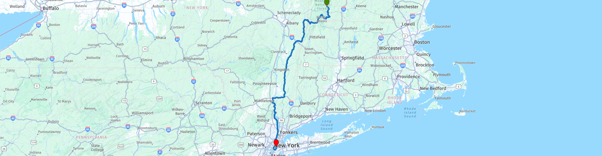
Dover to New York

This route was brought to you by:
RouteXpert Paul Hedges - Adv RouteXpert
Last edit: 06-01-2020
 Route Summary
  Share this route


Animation

Verdict


Duration
6h 52m

Mode of travel
Car or motorcycle

Distance
402.42 km

Countries

 RouteXpert Review
 At Heartwellville a turn to the left onto the 8 heading south towards Massachusetts
Arriving in North Adams it is time for a coffee break. Linda’s café (WP13) is open from 06:00 so always a good choice.
Out of Williamstown take a right onto the Mohawk Trail and ride through Taconic Trail State Park, the road slowly creeps upwards as you lean from left to right through the curves in front of you. As you reach the top the views of Mount Raimer just appear in front of you as you cross the state line into New York State.
Arriving in Petersburg take a left onto the 22 and head south again, this is a nice free flowing road with lots of trees with the odd gap where you see the mountains around you. A right turn onto the 30 takes you along the shore of Queechy Lake before you join the 295. A fuel break (WP23) before you join the Taconic State Parkway. 60 miles of 2 lane road that lets you relax and enjoy the scenery as you ride along.
Turn right onto Highway 84 and head towards the Hudson river where you cross the Hamilton Fish Newburgh–Beacon Bridge (WP27). Just after the bridge take the exit for 9W and head south through Newburgh. A break for coffee and donuts (WP29) is now needed.
Continue down the 9W and the take a left on the 218 through Cornwall-on-Hudson. This leads to the Storm King Highway which follows the Hudson River. Some great views across the water with a chance to stop and take photographs (WP33) the road joins back up with the 9W as you head towards Fort Montgomery and it’s historical site (WP35). Continue south alongside the Hudson and take some time to pull over and see the Hudson River Reserve Fleet Memorial (WP37)
As you enter Nyack then it is time for more coffee and pie and Dish Café (WP42). Continue down the 9W until it joins the Pallisades Interstate Parkway. This will lead down to the Jersey Turnpike which you take over the George Washington Bridge (WP49) to the northern part of New York City.
Once you have crossed the bridge turn onto Harlem River Drive as the traffic continues to build. Ride through Upper Manthatten and Harlem and head towards Central Park.
Take a left onto 97th Street and ride through Central Park before turning left onto 5th Avenue as it heads towards Manhatten. As you cross 35th street you will pass the Empire State Building (WP57) and then continue into Greenwich Village before taking a right onto W 9th Street. At the junction of Bedford and Grove Street (WP60) look up to see the outside shots that were used for where the characters from Friends lived.
Head through downtown New York before crossing the Brooklyn Bridge (WP64) and onto the Brooklyn Queens Expressway. The final leg is turning into Queens and stopping at LIC Hotel for the night


 Links
Links  Usage
Usage Want to download this route?
You can download the route for free without MyRoute-app account. To do so, open the route and click 'save as'. Want to edit this route?
No problem, start by opening the route. Follow the tutorial and create your personal MyRoute-app account. After registration, your trial starts automatically.  Disclaimer
Use of this GPS route is at your own expense and risk. The route has been carefully composed and checked by a MyRoute-app accredited RouteXpert for use on TomTom, Garmin and MyRoute-app Navigation.
Changes may nevertheless have occurred due to changed circumstances, road diversions or seasonal closures. We therefore recommend checking each route before use.
Preferably use the route track in your navigation system. More information about the use of MyRoute-app can be found on the website under 'Community' or 'Academy'.

Vermont
About this region
Vermont is a state in the New England region of the United States. It borders the states of Massachusetts to the south, New Hampshire to the east, and New York to the west, and the Canadian province of Quebec to the north. Vermont is the only state in New England that does not border the Atlantic Ocean. Vermont is the second-least-populated U.S. state after Wyoming and the sixth-smallest by area of the 50 U.S. states with a recorded population of 643,503 according to the 2020 U.S. census. The state capital is Montpelier, the least-populous state capital in the United States. The most-populous city, Burlington, is the least-populous city to be the most-populous city in a state.
For some 12,000 years, indigenous peoples inhabited this area. The historically competitive tribes of the Algonquian-speaking Abenaki and Iroquoian-speaking Mohawk were active in the area at the time of European encounter. During the 17th century, French colonists claimed the territory as part of the Kingdom of France's colony of New France. After the Kingdom of Great Britain began to settle colonies to the south along the Atlantic coast, the two nations competed in North America in addition to Europe. After being defeated in 1763 in the Seven Years' War, France ceded its territory east of the Mississippi River to Great Britain.
Thereafter, the nearby British Thirteen Colonies, especially the provinces of New Hampshire and New York, disputed the extent of the area called the New Hampshire Grants to the west of the Connecticut River, encompassing present-day Vermont. The provincial government of New York sold land grants to settlers in the region, which conflicted with earlier grants from the government of New Hampshire. The Green Mountain Boys militia protected the interests of the established New Hampshire land grant settlers against the newly arrived settlers with land titles granted by New York. Ultimately, a group of settlers with New Hampshire land grant titles established the Vermont Republic in 1777 as an independent state during the American Revolutionary War. The Vermont Republic abolished slavery before any of the other states.Vermont was admitted to the newly established United States as the fourteenth state in 1791. During the mid-19th century, Vermont was a strong source of abolitionist sentiment, although it was also tied to King Cotton through the development of textile mills in the region, which relied on southern cotton. It sent a significant contingent of soldiers to participate in the American Civil War.
The geography of the state is marked by the Green Mountains, which run north–south up the middle of the state, separating Lake Champlain and other valley terrain on the west from the Connecticut River valley that defines much of its eastern border. A majority of its terrain is forested with hardwoods and conifers, and a majority of its open land is devoted to agriculture. The state's climate is characterized by warm, humid summers and cold, snowy winters.
Vermont's economic activity of $34 billion in 2018 ranked last on the list of U.S. states and territories by GDP but 34th in GDP per capita. In 2000, the state legislature was the first to recognize civil unions for same-sex couples.
Read more on Wikipedia
For some 12,000 years, indigenous peoples inhabited this area. The historically competitive tribes of the Algonquian-speaking Abenaki and Iroquoian-speaking Mohawk were active in the area at the time of European encounter. During the 17th century, French colonists claimed the territory as part of the Kingdom of France's colony of New France. After the Kingdom of Great Britain began to settle colonies to the south along the Atlantic coast, the two nations competed in North America in addition to Europe. After being defeated in 1763 in the Seven Years' War, France ceded its territory east of the Mississippi River to Great Britain.
Thereafter, the nearby British Thirteen Colonies, especially the provinces of New Hampshire and New York, disputed the extent of the area called the New Hampshire Grants to the west of the Connecticut River, encompassing present-day Vermont. The provincial government of New York sold land grants to settlers in the region, which conflicted with earlier grants from the government of New Hampshire. The Green Mountain Boys militia protected the interests of the established New Hampshire land grant settlers against the newly arrived settlers with land titles granted by New York. Ultimately, a group of settlers with New Hampshire land grant titles established the Vermont Republic in 1777 as an independent state during the American Revolutionary War. The Vermont Republic abolished slavery before any of the other states.Vermont was admitted to the newly established United States as the fourteenth state in 1791. During the mid-19th century, Vermont was a strong source of abolitionist sentiment, although it was also tied to King Cotton through the development of textile mills in the region, which relied on southern cotton. It sent a significant contingent of soldiers to participate in the American Civil War.
The geography of the state is marked by the Green Mountains, which run north–south up the middle of the state, separating Lake Champlain and other valley terrain on the west from the Connecticut River valley that defines much of its eastern border. A majority of its terrain is forested with hardwoods and conifers, and a majority of its open land is devoted to agriculture. The state's climate is characterized by warm, humid summers and cold, snowy winters.
Vermont's economic activity of $34 billion in 2018 ranked last on the list of U.S. states and territories by GDP but 34th in GDP per capita. In 2000, the state legislature was the first to recognize civil unions for same-sex couples.
View region
 Statistics
  7
7Amount of RX reviews (Vermont)
 9204
9204Amount of visitors (Vermont)
 171
171Amount of downloads (Vermont)
 Route Collections in this region
 Ultimate USA road trip part 07
Michel van Hagen challenged me to follow the Roadtrip of Dr. Randy Olsen as a basis to create the Ultimate USA Road Trip for the MyRoute app RouteXpert Library. I took up that challenge and started in February 2022.
The scientist Dr. Randy Olsen, who became known for using his knowledge of algorithms to find 'Waldo' in the well-known American 'Where's Waldo' book series, has been challenged by Tracy Staedter, from Discovery News, to use the same algorithm to create the perfect Road Trip by creating the US, which will visit almost every state in the US. Alaska and Hawaii are not included in this Road Trip due to their geographical location.
The following three requirements formed the basis of the route: In all 48 countries there must be at least one stop at famous points, monuments, historical sites, national parks, etc. I have added additional interesting points, beautiful tours and routes.
After more than 26 months, the job is finished and, with a lot of support from Nick Carthew, I have created 129 routes that run through the 48 states of the USA and part of Canada. This is the seventh collection that takes you from Salem in ten days through Massachusetts, Maine, New Hampshire, Vermont, New York, Canada, Pennsylvania and Ohio to Mackinaw City, Michigan.
View Route Collection