Westerwald Rhein Eifel

This route was brought to you by:
RouteXpert Stefan Otten - RouteXpert
Last edit: 21-04-2019
 Route Summary
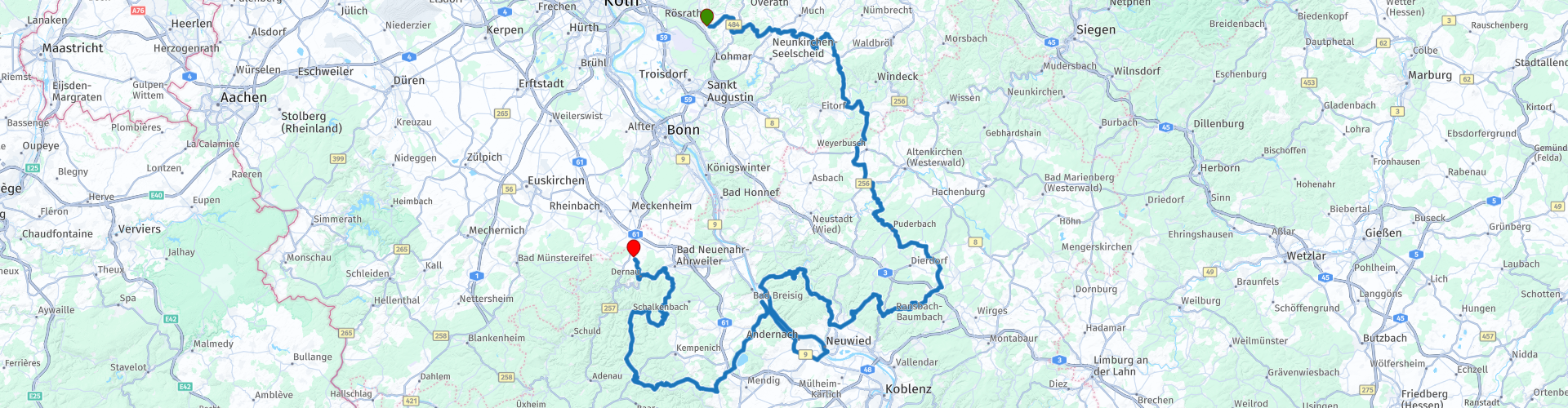
 Starting point Rösrath
Endpoint Dernau
 Share this route


Animation

Verdict


Duration
5h 39m

Mode of travel
Car or motorcycle

Distance
245.70 km

Countries

 RouteXpert Review
 Of Romans, legends, the Rhine and the wine
The Westerwald with its enchanted landscapes is the scene of a variety of legends, myths and legends. Often these have a historical background, be it colonization by the Celts or the wars of Sweden. Some legends, for example about the work of the devil, bear witness to the deeply rooted Christian-religious world view and other stories can be traced back to the living conditions of the social strata of the time. In misty brook valleys, on windy heights and in dark mine tunnels, even today mysterious creatures are said to be up to mischief. With a little imagination, shadows turn into fabulous creatures like the Tholm or the Muhkalb at dusk. Those who are attentive, discover clues to hidden treasures, whoever drives carelessly, might catch the nasty little fellow ...
(Source: http://www.sagenhafter-westerwald.com)
The route starts near Rösrath. From there we cross the victory and land directly in the Westerwald.
Technically you can look forward to the Sayntal. A really nice piece of road for our motorcycles.
The Sayntal begins shortly after waypoint 18. At the end of the Saytal you pass a small motorcycle club, Isenburg. More information can be found in the following link.
http://zur-isenburg.de/
Do not eat too much in the Isenburg, because it goes on through the beautiful Westerwald to a small ski and hiking hut on route point 22. Here are great cakes but also hearty. The view is great!
Please check the opening times with the following link. Sometimes companies take place here.
https://www.malberg-huette.de/index.php
From here you continue down to the Rhine. On the way to the Rhine ferry you pass an old watchtower of the Roman Limes (route point 25). It is worth to look at it once.
https://www.roemer-welt.de/Limes-Infozentrum/
You take the ferry and land in the volcanic Eifel.
A relic from the time of fire and ice is the Laacher See.
https://de.wikipedia.org/wiki/Laacher_See
Directly at the Laacher lake is the Benediktinier Abbey Maria Laach. For those who like "old stones", a stay here is a must. (Route point 30)
https://www.maria-laach.de/
Now continue and you can culturally educate yourself after the beautiful roads of the Eifel.
The excavation of an old Roman villa can be visited at waypoint 35. You will receive more information about the villa in the following link.
https://roemer-spuren.de/museen/ahrweiler
And who wants to end the tour neatly after all the curves and Romans, which is in good hands at waypoint 36 in the ostrich farm "Im Burggarten". At least the Sozia can enjoy a delicious wine from the growing region here.
http://www.kreuzberg-burggarten.de/
At the end of the tour there is still a great view at waypoint 36.
Here you can make great photos of the Ahr Valley.
I wish you a lot of fun on the tour!
Please always keep the black below.


 Usage
Usage Want to download this route?
You can download the route for free without MyRoute-app account. To do so, open the route and click 'save as'. Want to edit this route?
No problem, start by opening the route. Follow the tutorial and create your personal MyRoute-app account. After registration, your trial starts automatically.  Disclaimer
Use of this GPS route is at your own expense and risk. The route has been carefully composed and checked by a MyRoute-app accredited RouteXpert for use on TomTom, Garmin and MyRoute-app Navigation.
Changes may nevertheless have occurred due to changed circumstances, road diversions or seasonal closures. We therefore recommend checking each route before use.
Preferably use the route track in your navigation system. More information about the use of MyRoute-app can be found on the website under 'Community' or 'Academy'.