Zwartewoud Baden Baden naar Schopfheim

This route was brought to you by:
RouteXpert Frank
Last edit: 08-02-2019
 Route Summary
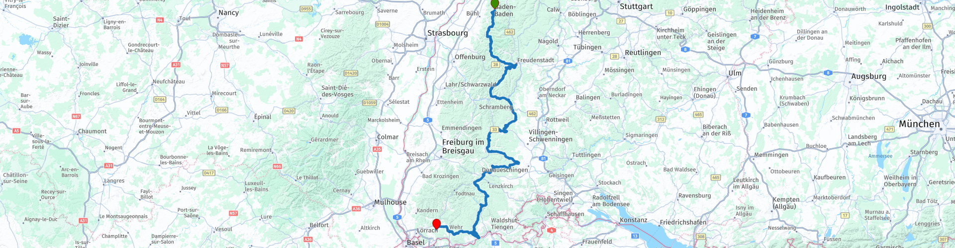
 Starting point is near Baden-Baden and ends in Schopfheim.
This route is part of a 6-day tour through the Black Forest and the Vosges.
Starting point: Landgasthof Hirsch just outside Baden-Baden
End point: hotel Hohe Flum in Schopfheim
 Share this route


Animation

Verdict


Duration
5h 2m

Mode of travel
Car or motorcycle

Distance
279.40 km

Countries


 RouteXpert Review
 The route goes straight through the Black Forest. This region is popular with many motorcyclists and that is not for nothing. On the way we enjoy beautiful views over the valleys and lakes of the Black Forest.
This area is the largest low mountain range in Germany. The Romans called the densely wooded mountain range with its characteristic dark pine trees Silva Nigra, which was ominous and almost impenetrable to them. This area is seen by many people as the most beautiful engine area in Germany. It will therefore be a very varied trip with a fantastic route.
The route starts directly on the B500, also known as the Schwarzwaldhochstraße, the oldest and perhaps the most beautiful route through the Black Forest. Construction started in 1930 and finally finished in 1952. The Straße winds up to the top of the Bühlerhöhe. The road continues along the mountains, with beautiful views to Freudenstadt on the east side of the forest, and all at an altitude between 800 and 1000 meters.
During this route, the mythical stories of this ever so impenetrable forest will surely appeal to your imagination, just like the least challenging smaller roads, the beautiful river valleys, beautiful churches and always pleasant Biergarten.
We will do this lunch in Schönwald at Landgasthof Falken.
Furthermore, this region is also called the cradle of cuckoo clock, typical wooden houses and the irresistible traditional Schwarzwalder Kirschtorte
On the way a short photo moment, see photo above. There are also plenty of beautiful places along this route to enjoy the view and / or take some pictures.
Then you come between route points 10 and 11 you pass two large lakes, including the Titisee. This lake has an area of 1.3 square kilometers, is 20 meters deep on average and lies at 1000 meters above sea level. The lake is fed by the Feldberg Glacier.
We also drive along the Schluchsee, the largest reservoir in the Black Forest. It lies at 930 meters above sea level and is therefore the highest reservoir in Germany.
After the Schluchsee it is still about 1H30M drive to the terminus in Schopfheim, beautifully situated hotel on a hill overlooking the valley.
I gave this route 5 stars because it has everything that makes motorcycling fun. The varied landscape, the beautiful mountain climate and the large amount
beautiful roads with both slow and fast turns, lots of hairpins and many beautiful views.
Route comments:
rp 6 - Lunch at Landgasthof Falken.
rp 8 - Short photo moment, see picture above. Be careful, it is not an official stopping point, but there is little traffic.
Tip: Next to this hotel is another lookout tower. Definitely worth it. From this point you can look forward to Switzerland and France.


 Links
Links  Usage
Usage Want to download this route?
You can download the route for free without MyRoute-app account. To do so, open the route and click 'save as'. Want to edit this route?
No problem, start by opening the route. Follow the tutorial and create your personal MyRoute-app account. After registration, your trial starts automatically.  Disclaimer
Use of this GPS route is at your own expense and risk. The route has been carefully composed and checked by a MyRoute-app accredited RouteXpert for use on TomTom, Garmin and MyRoute-app Navigation.
Changes may nevertheless have occurred due to changed circumstances, road diversions or seasonal closures. We therefore recommend checking each route before use.
Preferably use the route track in your navigation system. More information about the use of MyRoute-app can be found on the website under 'Community' or 'Academy'.