Clubdag 2018 Heeten Haminkeln

This route was brought to you by:
RouteXpert Hans Lamers - RouteXpert
Last edit: 11-01-2022
 Route Summary
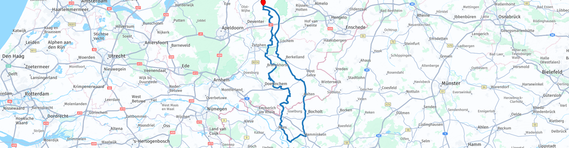
 The route goes from Heeten to Thunderbike Roadhouse in Hamminkeln Germany and again to Heeten.
The start and end point of this route is at Brasserie Dert13n In Heeten.
I drove this route on September 15, 2018.
 Share this route


Animation

Verdict


Duration
4h 44m

Mode of travel
Car or motorcycle

Distance
220.92 km

Countries


 RouteXpert Review
 It is a club day of MC Freewheels from Heeten. Every year a nice route is set out with the aim of "a nice ride on the motorcycle and an activity".
The activity we did in 2018 is to visit the Harley dealer in Hamminkeln.
This dealer, Thunderbike, specializes in building custom engines. When it comes to raising, lowering, widening or you want special design rims, it's all possible.
"Real custom work with solid advice"
We had a tour of the entire company and were able to see in detail how accurately they work.
Most of it is old-fashioned manual work, such as making special tanks and outlets. All of this is carried out by motivated professionals who talk about it with passion. This of course also resulted in nice conversations.
For more information also look at useful Links under Thunderbike.
You can eat at the adjacent restaurant called Thunderbike Roadhouse where many bikers come and it is very cozy. After having consumed something here, it is time to mount our own steel steed again.
The tough feeling of some club members can still be seen in their seating position.
In this way we pass a little further along Lake Empel, a beautiful photo moment.
The ruins of Empel Castle lie on Lake Empel. This castle dates from the early 13th century. Over the years, the castle has been owned by various owners. At the end of the Second World War, at the time of the liberation, the Germans used the castle to block the road of the Allies to Bocholt from there. Many castles were taken by the Germans during the war as observation tower, as shelter for troops and officers or as storage space for weapons and ammunition. Castles were also deliberately destroyed to prevent them from being used by enemy forces. Almost half of the total damage to castles and country estates occurred in the Netherlands during the last year of the war. This castle was also completely destroyed in the last months of the war. A ruin was the only thing left and reconstruction was not financially feasible for a long time. The reconstruction of the castle ruins was only started in 2000. Nowadays the castle is privately owned.
You can find this information at useful Links under Ruin Haus Empel.
Then we quietly started on the way back and during the ride we passed several places where you can have a cup of coffee, refuel or stop for a photo.
I have included a few places in the details.
I have given the route 4 stars because I personally think it is a beautiful route. No spectacular curves or height differences but just nice driving.
Another successful club day!
Route details:
Route point 5 - Thunderbike Roadhouse photo opportunity and lunch
Route point 8 - Photo moment Kasteel Empel
Route point 14 - Coffee stop


 Links
Links  Usage
Usage Want to download this route?
You can download the route for free without MyRoute-app account. To do so, open the route and click 'save as'. Want to edit this route?
No problem, start by opening the route. Follow the tutorial and create your personal MyRoute-app account. After registration, your trial starts automatically.  Disclaimer
Use of this GPS route is at your own expense and risk. The route has been carefully composed and checked by a MyRoute-app accredited RouteXpert for use on TomTom, Garmin and MyRoute-app Navigation.
Changes may nevertheless have occurred due to changed circumstances, road diversions or seasonal closures. We therefore recommend checking each route before use.
Preferably use the route track in your navigation system. More information about the use of MyRoute-app can be found on the website under 'Community' or 'Academy'.

North Rhine-Westphalia
About this region
North Rhine-Westphalia (German: Nordrhein-Westfalen, pronounced [ˌnɔʁtʁaɪn vɛstˈfaːlən] (listen); Low Franconian: Noordrien-Wesfale; Low German: Noordrhien-Westfalen; Colognian: Noodrhing-Wäßßfaale), commonly shortened to NRW (German: [ɛnʔɛʁˈveː] (listen)), is a German state (Land) in Western Germany. With more than 17.9 million inhabitants, it is the most populous state of Germany. Covering an area of 34,084 square kilometres (13,160 sq mi), it is the fourth-largest German state by size. Apart from the city-states, it is also the most densely populated state in Germany.
North Rhine-Westphalia features 30 of the 81 German municipalities with over 100,000 inhabitants, including Cologne (over 1 million), the state capital Düsseldorf, Dortmund and Essen (all about 600,000 inhabitants) and other cities predominantly located in the Rhine-Ruhr metropolitan area, the largest urban area in Germany and the third-largest on the European continent. The location of the Rhine-Ruhr at the heart of the European Blue Banana makes it well connected to other major European cities and metropolitan areas like the Randstad, the Flemish Diamond and the Frankfurt Rhine-Main Region.
North Rhine-Westphalia was established in 1946 after World War II from the Prussian provinces of Westphalia and the northern part of Rhine Province (North Rhine), and the Free State of Lippe by the British military administration in Allied-occupied Germany and became a state of the Federal Republic of Germany in 1949. The city of Bonn served as the federal capital until the reunification of Germany in 1990 and as the seat of government until 1999.
Culturally, North Rhine-Westphalia is not a uniform area; there are significant differences, especially in traditional customs, between the Rhineland region on the one hand and the regions of Westphalia and Lippe on the other. The state has always been Germany's powerhouse with the largest economy among the German states by GDP figures.
Read more on Wikipedia
North Rhine-Westphalia features 30 of the 81 German municipalities with over 100,000 inhabitants, including Cologne (over 1 million), the state capital Düsseldorf, Dortmund and Essen (all about 600,000 inhabitants) and other cities predominantly located in the Rhine-Ruhr metropolitan area, the largest urban area in Germany and the third-largest on the European continent. The location of the Rhine-Ruhr at the heart of the European Blue Banana makes it well connected to other major European cities and metropolitan areas like the Randstad, the Flemish Diamond and the Frankfurt Rhine-Main Region.
North Rhine-Westphalia was established in 1946 after World War II from the Prussian provinces of Westphalia and the northern part of Rhine Province (North Rhine), and the Free State of Lippe by the British military administration in Allied-occupied Germany and became a state of the Federal Republic of Germany in 1949. The city of Bonn served as the federal capital until the reunification of Germany in 1990 and as the seat of government until 1999.
Culturally, North Rhine-Westphalia is not a uniform area; there are significant differences, especially in traditional customs, between the Rhineland region on the one hand and the regions of Westphalia and Lippe on the other. The state has always been Germany's powerhouse with the largest economy among the German states by GDP figures.
View region
 Statistics
  122
122Amount of RX reviews (North Rhine-Westphalia)
 42564
42564Amount of visitors (North Rhine-Westphalia)
 23434
23434Amount of downloads (North Rhine-Westphalia)
 Route Collections in this region
 The 10 most beautiful car and motorcycle routes in Limburg
Limburg, who thinks of Limburg, thinks of flan, coal mines, marl and the hill country. The coal mines have been closed for almost 40 years, the last load of coal was brought up from the Oranje-Nassau coal mine in Heerlen on 31 December and, as they say, South Limburg was transformed from Black to Green and unfortunately there is still little left. view of this period.
But not only pie, marl and coal in Limburg, but also a very beautiful province to tour by car or motorcycle and enjoy all the beauty that the province of Limburg has to offer. For this, the MyRoute app RouteXpert has put together a Top 10 of Car and Motorcycle routes for you.
All routes in this collection have been checked and made equal for TomTom, Garmin and MyRoute-app Navigation by a MyRoute-app RouteXpert.
If you think, I have a very nice route that should certainly not be missing from this collection, send it to:
email: routeexpert@myrouteapp.com
Subject: New Route for the Top 10 collection Province of Limburg composed by Hans van de Ven.
The route will then be reviewed and then added to the Top 10.
To make the Top 10 also the Top 10, 1 route will have to disappear from the Top 10, you can indicate this when submitting the new route.
Have fun with this collection and while driving one of these routes. Enjoy all the beauty that the Netherlands and in particular the province of Limburg has to offer. Click on “View route” to read the review of the chosen route.
I would like to hear your findings about the route(s).
View Route Collection
Top 5 Car and Motorcycle Routes in the Eifel
The Eifel is the eastern part of the medium plateau Eifel-Ardennes. It is located north of the Moselle and west of the Rhine. The largest part is in Germany, a small part is in Belgium, in the East Cantons. The German part of Eifel is located in the federal states of North Rhine-Westphalia and Rhineland-Palatinate. The highest point is the Hohe Acht with 747 meters.
Several chains can be distinguished in the Eifel:
The northernmost part is called the Nordeifel, which in Belgium connects to the High Fens;
To the east of this is the Ahrgebirge, this part is located north of the Ahr in the Ahrweiler district;
South of the Ahr is the Hohe Eifel (or Hocheifel), of which the Hohe Acht (747 m) is the highest point, and also the highest point in the entire Eifel region;
To the west, near the Belgian border, the hills are known as Schneifel, part of the wider Snow Eifel area with peaks reaching up to 698 metres;
South and east of the Hohe Eifel is the Volcano-Eifel, a volcanic area with many crater lakes (Maare).
The southern part of the Eifel is less high. The area is bisected by streams and rivers running southwards. These streams flow into the Moselle. The largest of these rivers is the Kyll; the hills around this river are known as the Kyllwald;
In the south, the Eifel ends in the Voreifel.
In the north of the Eifel there are some large reservoirs. The largest of these is the reservoir in the Roer that was created by the construction of the Roerdal dam.
The Nürburgring is also located in the Eifel, a well-known car circuit for Formula 1 races, among other things. Since 2004, part of the north of the Eifel has become the Eifel National Park. This National Park falls entirely within the German-Belgian nature park High Fens-Eifel. Another part of the Eifel falls within the South Eifel Nature Park.
Well-known throughout the Netherlands and Belgium by car and motorcyclists, so reason enough for the MyRoute app RouteXpert to compile a Top 5 of Car and Motorbike routes for you.
All routes in this collection have been checked and made equal for TomTom, Garmin and MyRoute-app Navigation by a MyRoute-app RouteXpert.
If you think, I have a very nice route that should certainly not be missing from this collection, send it to:
email: routeexpert@myrouteapp.com
Subject: New Route for the Top 5 collection Eifel composed by Hans van de Ven.
The route will then be reviewed and then added to the Top 5. To make the Top 5 also the Top 5, 1 route will have to disappear from the Top 5, you can indicate this when submitting the new route.
Have fun with this collection and while driving one of these routes. Enjoy all the beauty that the Eifel has to offer. Click on “View route” to read the review of the chosen route.
I would like to hear your findings about the route(s).
View Route Collection