MTG1 08 Roundtrip Southern Vercors Drome Barbieres Die Barbieres

This route was brought to you by:
RouteXpert René Plücken (MRA Master)
Last edit: 29-05-2021
 Route Summary
  Share this route


Animation

Verdict


Duration
6h 16m

Mode of travel
Car or motorcycle

Distance
170.80 km

Countries

 RouteXpert Review
 Bert Loorbach, the writer, is an enthusiastic motorcyclist himself and lived in France for a year and a half. During that time he devoted himself to mapping the unknown and beautiful roads of France especially for motorcyclists.
Hotels, campsites, places of interest, parking spaces and restaurants are listed as POIs.
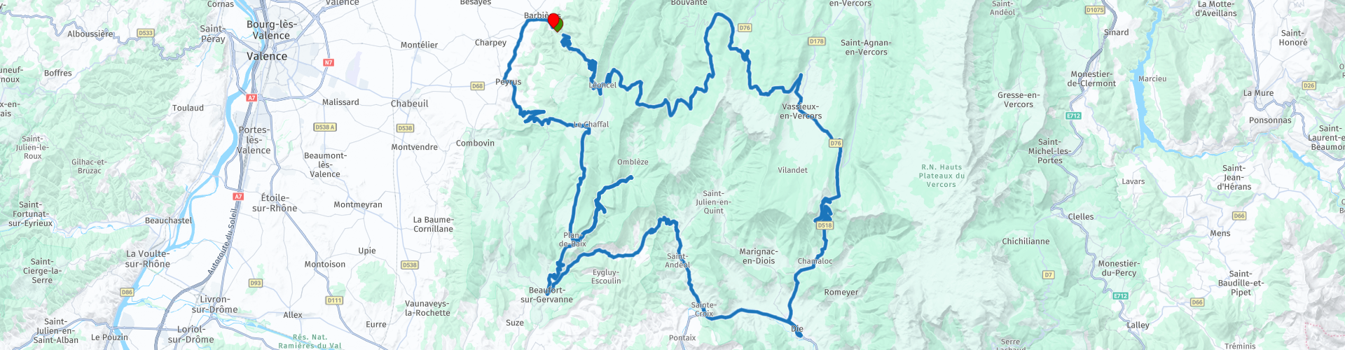
Barbières is a very small village with only a campsite in the immediate vicinity, but a wonderful point to start this tour through the southern part of Vercors. This motor-friendly site has a Roman atmosphere. The roads are very winding and there are many small parking places along the way to stop and enjoy the panoramas.
The route contains several mountain passes and therefore has the necessary ascents and descents, there are also some spicy hairpin bends.
There is a small resistance museum in the village of Vassieux-en-Vercors.
The next mountain pass is the Col du Rousset (RP6), which marks the climate line between the northern and southern Alps. After this climb we drive down great curves to the town of Die (RP8), where we stop for lunch in one of the many restaurants of this 70s style village.
After lunch we drive along the Drôme river to Sainte Croix, you can stop at RP10 to take a nice picture of the river. We drive on the narrow D129 and D172, Col de la Croix with its nice hairpin bends further towards Beaufort-sur-Gervanne.
We continue the ride on the D70, halfway at the T-junction we take the D578 to view the Chute de la Druise (RP14) waterfall. This waterfall is the best way to view it from below, for that you have to walk. We drive further up to take a short break at Hotel restaurant Le Moulin de la Pipe (RP15).
After the break we drive back down and enter the Col de Bacchus, just before La Vacherie we turn to the D68 and descend over the Col de Limouches, again a delightful steering road with the necessary hairpins and panoramas. Via Peyrus we drive back to Barbières.
This route is a nice short tour with many beautiful mountain passes, a succession of curves through beautiful surroundings. A short trip on the route to view the waterfall is certainly worth it. I rate this route with 5 stars.
The route is made suitable for Garmin, TomTom, Harley-Davidson BoomBox 2019 and Navigation App.
Can be downloaded for free and without My-Route-app registration. To do this, first click on the 'Use route' button and then on 'Save as'.


 Links
Links  Usage
Usage Want to download this route?
You can download the route for free without MyRoute-app account. To do so, open the route and click 'save as'. Want to edit this route?
No problem, start by opening the route. Follow the tutorial and create your personal MyRoute-app account. After registration, your trial starts automatically.  Disclaimer
Use of this GPS route is at your own expense and risk. The route has been carefully composed and checked by a MyRoute-app accredited RouteXpert for use on TomTom, Garmin and MyRoute-app Navigation.
Changes may nevertheless have occurred due to changed circumstances, road diversions or seasonal closures. We therefore recommend checking each route before use.
Preferably use the route track in your navigation system. More information about the use of MyRoute-app can be found on the website under 'Community' or 'Academy'.