MTG1 06 BainsLesBains LuxeuilLeBains Villersexel Ouhans Ornans MontrealLaCluse

This route was brought to you by:
RouteXpert René Plücken (MRA Master)
Last edit: 12-02-2021
 Route Summary
  Share this route


Animation

Verdict


Duration
6h 17m

Mode of travel
Car or motorcycle

Distance
347.19 km

Countries

 RouteXpert Review
 Review
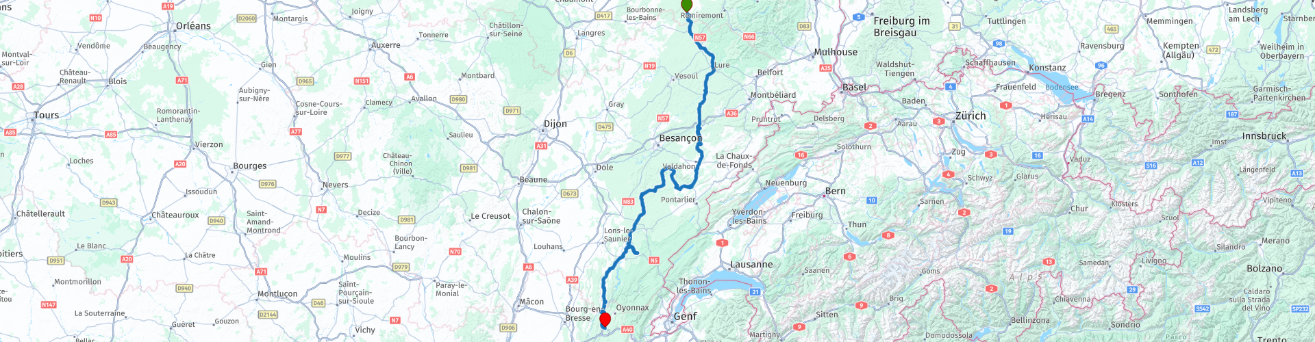
This is the sixth route from the Motorbike Guide and this route crosses five departments and avoids larger towns. He takes us from the Vosges to the Jura and the precursors of the Alps and starts in Bains-Les-Bains.
There are hotels and campsites in the vicinity, which are listed as POIs.
You drive via the D164 to Luxeuil-Le-Bains (RP3). This city (spa) covered with a deciduous forest has a beautiful architectural heritage, including many city palaces from the 15th and 16th centuries: the Spanish house, the house of Le Bailli, the house of Cardinal Jouffroy and its balcony in late Gothic style, the oldest hanging stone balcony in France; the house of the spiritual French I, worn on arches, the octagonal tower of the Aldermen, archaeological museum and much more and certainly worth planning a sight seeing stop.
From Luxeuil-Les-Bains the journey continues on the D74 to Lure, this road runs through the area of the thousand small lakes.
From Lure you continue on the D486 to Villersexel, here you can stop to stretch your legs. Worth a visit is the Chateau de Villersexel. Parking at RP9.
After Villersexel you continue the journey via the D9 and D50 to Baumes-Les-Dames, this place is located in a somewhat wider part of the Doubs valley. The road is wonderfully relaxed to drive with the occasional beautiful views. In Baumes-Les-Dames there is a possibility to have lunch.
You drive via Grotte de La Glacière (RP13), a prehistoric cave with eternal ice, to Ouhans to see the origins of the Loue river, we drive along narrow winding roads to RP14. It is a 30-minute walk from the parking lot, but the spectacular spectacle of the river that is "born" of the rocks is definitely worth it.
From Ouhans we drive to Ornans (RP16), nicknamed the Little Venice of the Comté, offering the city of Ornans a lot of charm with its beautiful, old houses on stilts that reflect in the water of the Loue. This beautiful, picturesque whole can be admired from the Great Bridge and the pedestrian bridge that spans the river.
The Courbet Museum, which is located in the birthplace of the painter Gustave Courbet and which exhibits numerous works by this famous artist, is worth a visit for the enthusiast.
Via the beautiful D101 we drive to Scey-en-Varais, on the mountain stand the ruins of the castle St. Denis. Via the winding roads D9 and D492 you drive back to Salins-les-Bains, from where you follow the D467 to Lac de Chalain (RP21), where you can stop to enjoy the view over the beautiful lake.
The next town is Doucier, here are many rivers, lakes and waterfalls nearby. At RP23 you can visit the most beautiful waterfall “Cascades de l'Herisson”, for which you have to deviate about 8 kilometers from the route, definitely worth it.
Via Pont-de-Poitte and the Vouglans reservoir you drive to the end point of the Montreal La Cluse ride where you can spend the night at campsites or hotels around Lake Lac de Nantua.
Hotels, campsites, places of interest, parking spaces and restaurants are included as POI.
I appreciate this route with 4 stars because of the many sights and beautiful nature along the way. The roads are beautiful but not really challenging.
The route is made suitable for Garmin, TomTom, Harley-Davidson BoomBox 2019 and Navigation App.
Can be downloaded for free and without My-Route-app registration. To do this, first click on the 'Use route' button and then on 'Save as'.


 Links
Links  Usage
Usage Want to download this route?
You can download the route for free without MyRoute-app account. To do so, open the route and click 'save as'. Want to edit this route?
No problem, start by opening the route. Follow the tutorial and create your personal MyRoute-app account. After registration, your trial starts automatically.  Disclaimer
Use of this GPS route is at your own expense and risk. The route has been carefully composed and checked by a MyRoute-app accredited RouteXpert for use on TomTom, Garmin and MyRoute-app Navigation.
Changes may nevertheless have occurred due to changed circumstances, road diversions or seasonal closures. We therefore recommend checking each route before use.
Preferably use the route track in your navigation system. More information about the use of MyRoute-app can be found on the website under 'Community' or 'Academy'.