Day 10 of 12 Day Roadtrip Iceland Patreksfjordur Grundarfjordur

This route was brought to you by:
RouteXpert René Plücken (MRA Master)
Last edit: 12-02-2021
 Route Summary
 Driving in Iceland is a great experience whether you travel by car or as described in this review by motorcycle.
These routes are based on information about Iceland that you can find on the Internet, especially from the Guide to Iceland, where you can find a wealth of information to prepare you well for your trip. The material on this site has been compiled with great care, the link can be found in the review of the first route in this series.
You drive through landscapes that are varied and beautiful, you see glacier tongues, volcanic mountains, geothermal areas with active geysers, lava fields, craters, forests, waterfalls and incredibly rugged stretches of coast.
The routes in the north are part of the 'Arctic Coast Way'.
The main roads are of good quality but you also drive a lot on gravel roads, so not suitable for road motorcycles. Some of these roads are sometimes closed due to the weather. It is therefore important that you check the weather forecasts and the situation of the roads every day before you leave, this information can be found on the website of "Icelandic Meteorological Office" and for the roads on the website of "The Icelandic Road and Coastal Administration" " The links are in the review.
Due to the Icelandic climate, this trip can only be made in the summer.
 Share this route


Animation

Verdict


Duration
6h 12m

Mode of travel
Car or motorcycle

Distance
277.33 km

Countries

 RouteXpert Review
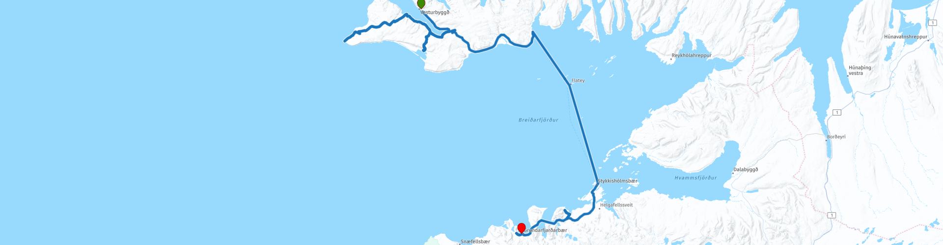
 To reach Látrabjarg from Patreksfjörður, follow Route 62 South to Route 612 and follow it until the end. The cliffs of Látrabjarg (RP2) are perhaps the most westerly point in Europe; although officially on the North American plate, Iceland is considered a European nation and no other sovereign European state has that far west. However, that is not what they are known for. These cliffs are best known for the millions of birds of dozens of species that nest here all summer. Gulls, olives, petrels and forty percent of the world's razor blades can be found on Látrabjarg, to name just a few, but most visitors come here looking for the puffins. They nest with thousands and are not afraid of people; you can come within reach without disturbing them, although for the sake of the birds you are not getting closer or trying to touch them. It is possible to walk along the edge of the cliffs for a spectacular view. They are 440 meters long at their highest point and extend over fourteen kilometers.
Return along the same road and turn onto Route 614 to reach your next destination, the beach of Rauðassandur (RP4). This stretch of coast is very unusual for Iceland; instead of the sand turning black from volcanic ash, the vivid colors are red, orange and pink. It is pleasant all year round, but if you are here in the first week of July, you can participate in the lively Rauðassandur music festival.
Now it's time to leave the Westfjords for the Snæfellsnes peninsula. Instead of taking a journey that would even last four hours, you start with a road trip to the sea and take the Baldur ferry from Brjánslækur (RP5) to Stykkishólmur (RP6). The crossing takes approximately 2½ hours and costs approximately € 175 for a motorcycle and driver. To reach Brjánslækur, return north to Route 612 and follow it eastwards to Route 62; take this road to the south and follow it to your destination.
As soon as you reach Stykkishólmur, you have time to explore the sites, as well as a few sites on the north side of the Snæfellsnes peninsula, such as the shark museum (RP7) where you get an explanation of how to process shark meat including tasting. Another point to visit is Mount Kirkjufell and the nearby waterfall, RP8 and 9 are the best places to stop for photos.
After this we have to drive back a little to Grundafjörður, where we spend the night.
A nice short route with a ferry crossing, along the way a number of beautiful roads and beautiful nature and wildlife. I therefore rate this route with 4 **** Stars.


 Links
Links  Usage
Usage Want to download this route?
You can download the route for free without MyRoute-app account. To do so, open the route and click 'save as'. Want to edit this route?
No problem, start by opening the route. Follow the tutorial and create your personal MyRoute-app account. After registration, your trial starts automatically.  Disclaimer
Use of this GPS route is at your own expense and risk. The route has been carefully composed and checked by a MyRoute-app accredited RouteXpert for use on TomTom, Garmin and MyRoute-app Navigation.
Changes may nevertheless have occurred due to changed circumstances, road diversions or seasonal closures. We therefore recommend checking each route before use.
Preferably use the route track in your navigation system. More information about the use of MyRoute-app can be found on the website under 'Community' or 'Academy'.