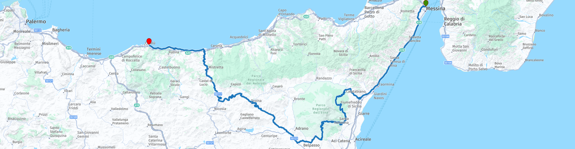
08 Messina to Cefalu via Mount Etna

This route was brought to you by:
RouteXpert Nick Carthew - (MRA Master)
Last edit: 23-12-2020
 Route Summary
 A scenic route from the ferry port of Messina visiting Europe's most active volcano, Mount Etna and then through the spectacular hilly countryside to the beautiful north coast town of Cefalù. A toll road is used at the start at a cost of: Motorcycle toll 2,60 € in 2019. Stunning coast, mountain and countryside route.
 Share this route


Animation

Verdict


Duration
7h 16m

Mode of travel
Car or motorcycle

Distance
315.90 km

Countries

 RouteXpert Review
 Climbing into the hills away from the coast you will arrive at the small town of Linguaglossa. It was founded on an ancient lava stream in 1566. The name literally means 'Tongue Tongue'. The arrow straight road out of town gives you your first good view of Etna at RP 11. The route starts to seriously climb now with a series of hairpin bends, each one offering increasingly higher views across the spectacular mountainous landscape. The landscape changes to pine forest the higher you climb and as it begins to level out, there is restaurant for coffee or early lunch at RP 12. Just a couple of kms on from the restaurant and you will see not only another great view of Etna, but you will be on one of her recent lava flows, a stark contrast of barren lava and green trees, some recently consumed by the molten rock. The route is now at about 1600 m, just halfway to the summit but must gently descend across more lava flows and pine forest to around 600 m where it passes through a couple of small towns before climbing again.
The second climb of the day is more thrilling than the first as there is less vegetation on the old lava flow that this route snakes up. Breathtaking views back towards the coast and the occasional glimpse back down onto the zig zag road. At RP 18 you will see the lava cave called Grotta dei Tre Livelli. (don't blink or you'll miss it). It's a 3 level cave (Tre Livelli) that was formed in the 1792/3 eruption and at 1150 m it is the longest lava cave on Etna.
Shortly after the cave you will arrive at Rifugio Sapienza, base camp of Mt Etna at 1900 m. The cable car will take you up to 2500 m in 15 minutes and a return ticket costs 30€ for another 33€ you can then jump onto a 4x4 Jeep that will take you to the edge of the crater at 2900 m. I would allow 3 hours for the complete trip.
For this part of the route alone, I would award the route 5 stars, the scenery/landscape and roads are excellent and what better attraction to see than Europe's most active volcano! The second part of this route just adds to the enjoyment of the first, I wish I could award more stars.
The road snakes its way back down off of the volcano with plenty of places to pull over for photo's. If you need coffee, food or fuel these can all be had at RPs 22 and 23. The route now travels through the heart of Sicily's beautiful hilly countryside, sometimes past olive plantations or citrus trees but always twisting and always with a view of distant hills. The ruins of the 17C Monastero basiliano di San Michele Arcangelo can be seen from RP 28 as you enter the town of Troina. The town has a rich history dating back to 7C BC. The Battle of Troina, part of the Allied invasion of Sicily, code named Operation Husky, was an important battle that took place between 31 July and 6 August 1943 during WW2. The battle focused around the numerous hills and mountains surrounding Troina which the Germans had heavily fortified making the fighting fierce. The next hilltop town along this route is Cerami, this hamlet briefly served as headquarters for the US 1st Infantry Division as it prepared to assault German strong points located north and south of Troina. The town demands commanding views and is easy to understand why the US wanted to use it as a base.
The route continues on twisty rural roads giving you views of Mt Etna along the way none more so better than from RP 31 the top of the Sella del Contrasto climb at 1120m. The route stays at around 1000m as it follows the contours and the line of modern windmills. Glimpses of the Tyrrhenian Sea and and the volcanic archipelago Aeolian Islands can be seen as you near the coast. You also get a great view of the islands and the A20 motorway as it disappears into the hillside through two tunnels at RP 35.
The next section follows the beautiful coast as you head west into the setting sun towards the 4**** Hotel Kalura. There are many other options for accommodation in the area. For a 4**** hotel it isn't overly expensive considering it's stunning location. As you would expect, there is secure parking and fabulous restaurant.
Ferry Information:
The ferry from the mainland leaves from Villa San Giovanni every 40 minutes and takes about 20 minutes to cross to Messina. There is no need to book and 2019 prices for a motorcycle 90 days return ticket was € 22.00 + 6.00.


 Links
Links  Usage
Usage Want to download this route?
You can download the route for free without MyRoute-app account. To do so, open the route and click 'save as'. Want to edit this route?
No problem, start by opening the route. Follow the tutorial and create your personal MyRoute-app account. After registration, your trial starts automatically.  Disclaimer
Use of this GPS route is at your own expense and risk. The route has been carefully composed and checked by a MyRoute-app accredited RouteXpert for use on TomTom, Garmin and MyRoute-app Navigation.
Changes may nevertheless have occurred due to changed circumstances, road diversions or seasonal closures. We therefore recommend checking each route before use.
Preferably use the route track in your navigation system. More information about the use of MyRoute-app can be found on the website under 'Community' or 'Academy'.