TTT 2011 05 Gaasterland

This route was brought to you by:
RouteXpert Hans van de Ven (Mr.MRA)
Last edit: 06-12-2020
 Route Summary
 The 173 ANWB Promoter TankTasTocht (TTT) were scanned by Henry ten Dam and signed by Leon Stolk in Mapsource and later placed as a Track in a .gpx file. These have been made available through the MrGPS website with the approval of the ANWB Promoter so that everyone can enjoy it. The 1st TTT is from 1992, so the route may differ slightly from the original.
I have checked all route points and, where necessary, placed them neatly on the road. Also, if necessary, I have further spaced the start point and end point of the route to avoid navigating directly to the end point and I added the POI files from the start and end point just like a possible stop point.
Finally, I made the route the same for TomTom, Garmin and MyRoute-app Navigation users.
Thanks to Henry, Leon, MrGPS and Promoter.
 Share this route


Animation

Verdict


Duration
3h 4m

Mode of travel
Car or motorcycle

Distance
138.70 km

Countries

 RouteXpert Review
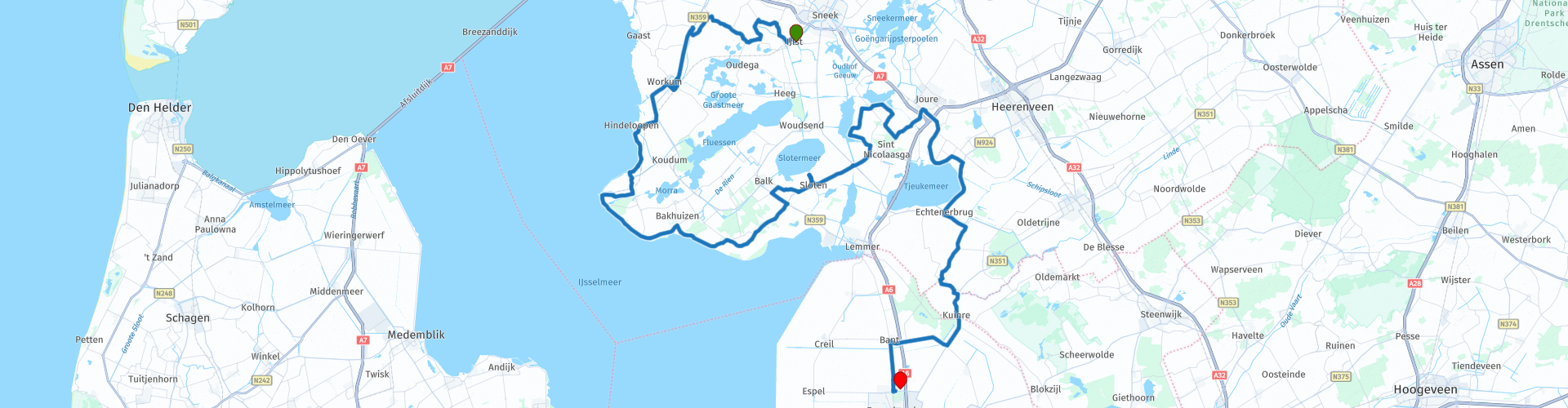
 * Gaasterland is a region in the southwest corner of the Dutch province of Friesland. The former municipalities of Gaasterland-Sloten and Nijefurd are part of Gaasterland (Source: Wikipedia).
About 45 minutes after you have left IJlst you arrive in Hindeloopen and you continue to drive along the IJsselmeer for almost 45 minutes, so you will pass through Stavoren where you can take a picture with Stavoren's wife **.
** One of the versions of the legend tells of a rich merchant widow in Stavoren who lived in a house with golden floors and silver walls.
After the IJsselmeer you head towards Slotermeer, where a lunch stop is also included in the route. After lunch you will continue to wind along the many Frisian lakes and through small towns towards Joure, plenty of opportunities to capture your motorcycle with a beautiful background in the photo. Almost in Joure you keep to the right to drive towards Lake Tjeukem, you go around it towards Emmeloord where the end point of this TTT is.
Because I have not (yet) driven this route myself, this route gets 3 stars.
Route details:
rp 14 - Here you can have a picture with Het vrouwtje van Stavoren and have a coffee
rp 26 - Lunch stop at Snackbar Sloten Fish & Snacks "By de Brêge"
The route has been made the same for TomTom, Garmin and MyRoute-app Navigation users. That has been successful everywhere except in Animals between route points 33 and 34 (Purple), where TomTom and Garmin disagree. Not a big problem, if you drive alone you just follow the instructions of your GPS, if you drive in a group then you follow the driver. From route point 34 the two come together again and your GPS will follow the route correctly again.


 Links
Links  Usage
Usage Want to download this route?
You can download the route for free without MyRoute-app account. To do so, open the route and click 'save as'. Want to edit this route?
No problem, start by opening the route. Follow the tutorial and create your personal MyRoute-app account. After registration, your trial starts automatically.  Disclaimer
Use of this GPS route is at your own expense and risk. The route has been carefully composed and checked by a MyRoute-app accredited RouteXpert for use on TomTom, Garmin and MyRoute-app Navigation.
Changes may nevertheless have occurred due to changed circumstances, road diversions or seasonal closures. We therefore recommend checking each route before use.
Preferably use the route track in your navigation system. More information about the use of MyRoute-app can be found on the website under 'Community' or 'Academy'.