Avond 4 daagse MTK IJsselrijders 1974 van uit Schalkhaar 2019

This route was brought to you by:
RouteXpert Hans Lamers - RouteXpert
Last edit: 11-01-2022
 Route Summary
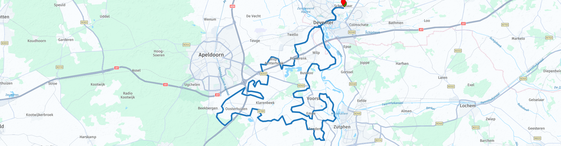
 The start and end point of the route is at café de Lindeboom in Schalkhaar.
I drove this route on Friday, June 21.
 Share this route


Animation

Verdict


Duration
3h 22m

Mode of travel
Car or motorcycle

Distance
104.89 km

Countries

 RouteXpert Review
 From the starting point "Café de Lindeboom" in Schalkhaar we went to Deventer. Cross the old IJsselbrug towards Steenenkamer.
Then it really started to get fun. We actually only drove on beautiful roads that are for motorcyclists to feast on. Via Posterenk, Wilp, Bussloo, Klarenbeek, Lieren direction Zutphen.
It is especially worthwhile to take a look at the recreational lake of Bussloo.
Bussloo is a recreational lake in Bussloo in the Dutch province of Gelderland. The lake is located in the middle of the Stedendriehoek between the cities of Apeldoorn, Deventer and Zutphen. The lake has an area of 100 hectares and is about 12 meters deep. The entire recreation area is approximately 300 hectares in size. The lake is managed and operated by Leisurelands.
The lake was created by sand excavation for the A1 motorway. Excavation began in 1968 and was completed in 1977; the year it was opened for recreation.
The recreational lake is used for numerous purposes: swimming (there is a large nudist beach), surfing, canoeing, pedal boating, diving (there is an underwater park including an underwater house, an underwater bus stop, an underwater coach and diving courses), on the beaches there are play facilities, in the immediate vicinity is a golf course and a mini golf course, there is a riding route and a dressage arena. In 2006 a sauna complex and 'wellness center' were opened at the recreational lake (Thermen Bussloo). Outside the high season, Bussloo is also often visited by day trippers, for walking and walking the dog (Source: Wikipedia).
We can say that we found Gelderland at its best . Especially the second part of the route is spectacular. "The beautiful long bends along the IJssel".
The IJssel is a branch of the Rhine that was created between 1500 and 2000 years ago after a sudden natural change in the course of the river. Recent research would indicate that the river was first fed with water from the Rhine only in the early Middle Ages, between about AD 500 and 950, which allowed it to become much wider and deeper. Before that, the area south-east of Zutphen drained to the south via the Oude IJssel and the Berkel. Due to a deteriorating discharge over time, a barrier at Zutphen would have been broken, causing the flow direction of the IJssel to shift to the north. Archaeologists point out that Deventer was already an important trading place around 800 with a free passage to the south. After all, Rhineland products were traded on a large scale and in 896 Deventer took over the position of the river trading town Dorestad. The IJssel is in any case a relatively young river that follows a much longer existing valley between Veluwe and Salland. (source: Wikipedia)
IJssel Riders thanks for the beautiful ride, it was another party for the motorcyclists.
I have given the route 4 stars because it is a delight for any motorcyclist. No height differences but nice curves, a must to drive.
Route details:
Route point 1 - Start of the route at café De Lindeboom Schalkhaar (open on Tuesday, Wednesday, Thursday and Sunday from 11 a.m.)
Route point 29 - Coffee stop / Break at rest point the Jodink
Route point 45 - View over IJssel
Route point 46 - View over IJssel with parking space
Route point 49 - End of the route at café De Lindeboom Schalkhaar


 Links
Links  Usage
Usage Want to download this route?
You can download the route for free without MyRoute-app account. To do so, open the route and click 'save as'. Want to edit this route?
No problem, start by opening the route. Follow the tutorial and create your personal MyRoute-app account. After registration, your trial starts automatically.  Disclaimer
Use of this GPS route is at your own expense and risk. The route has been carefully composed and checked by a MyRoute-app accredited RouteXpert for use on TomTom, Garmin and MyRoute-app Navigation.
Changes may nevertheless have occurred due to changed circumstances, road diversions or seasonal closures. We therefore recommend checking each route before use.
Preferably use the route track in your navigation system. More information about the use of MyRoute-app can be found on the website under 'Community' or 'Academy'.