04 Roundtrip Dobra via Vihorlat and Poloniny National Parks

This route was brought to you by:
RouteXpert Leonor Orban - Sr. RouteXpert
Last edit: 29-07-2021
 Route Summary
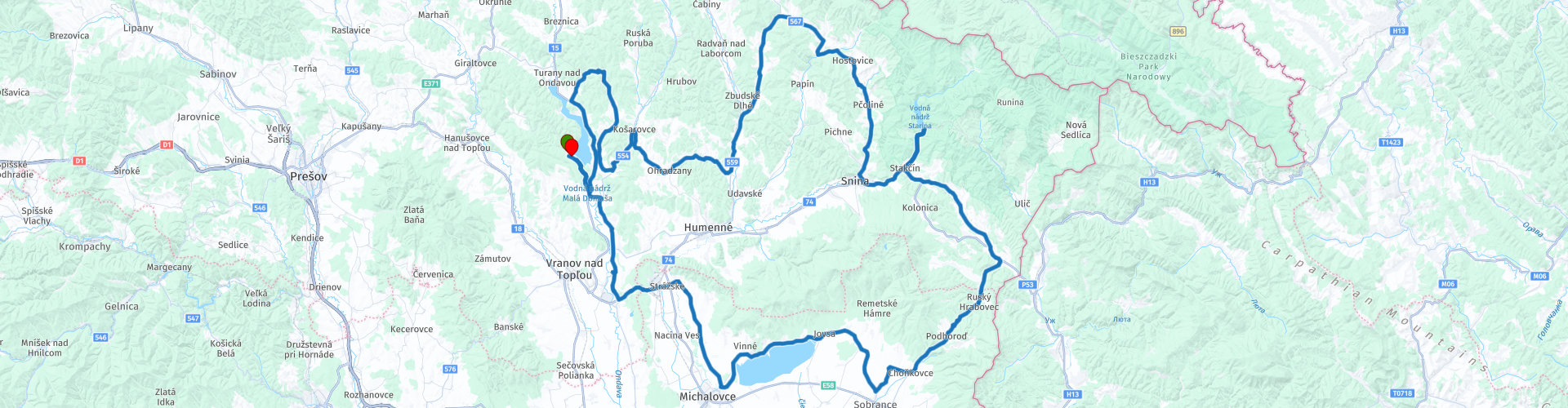
 Nature in particular is discussed during this tour. You cross the national parks of Vihorlat and Poloniny and pass the reservoirs of Starina and Zemplínska šírava. The latter known for its diversity of rare waterfowl.
The route gets a rating of 3 stars. In general, the through roads, technically not very challenging, are also regularly unavoidable through urban areas. There are also few cultural attractions along the route.
Due to the beautiful nature areas and views, the route remains a great way to relax for a few kilometers and to explore the east of Slovakia. Please note that the selection of restaurants and bars along the way may be limited.
 Share this route


Animation

Verdict


Duration
7h 17m

Mode of travel
Car or motorcycle

Distance
253.18 km

Countries

 RouteXpert Review
 First of all, make sure you have a good start to the day. Since today is simple and not too long, you can enjoy your breakfast in the guest house. Which is also handy, because you will not always easily find a lunch spot on the way.
We first drive a bit back on yesterday's route, towards the South. Soon you will say goodbye to the reservoir and continue the Ondava. This river originates in the Carpathians and follows a partly regulated 142 km route towards the south. The part of the river along which you are now driving. follows its own free path and you can see that at the wooden bridge. Here you can see the winding course of the river and you can take beautiful adventurous looking pictures of your motorcycle on the "rickety" bridge.
After this photo stop you continue your way to Strážske – Chemko, where you can refuel along the route for the first time.
At your leisure you continue towards the Zemplínska šírava water reservoir. Here you can stop for a short break at Cafe & Bar PLAVBA or a little further along the route at Langoše – Bufet, where you can eat delicious Hungarian Langoše (Lángos). Don't forget to stretch your legs and walk along the reservoir. You will not be alone, as the reservoir (affectionately also called “the Slovak Sea”) attracts many holidaymakers.
Driving along the reservoir you also see the landscape becoming more and more hilly. The mountains of the protected nature reserve Vihorlat are becoming increasingly visible. The route slides around the mountain range, where you may also encounter wildlife such as the lynx, wolf, wildcat and eagle.
The ascent and descent through Vihorlat flows seamlessly into a nice gentle climb to the Starina reservoir, located in the Poloniny National Park. The park, like Vihorlat, is partly a UNESCO world heritage site due to the presence of primeval beech trees. You can also encounter stray bison here, which were reintroduced to the region in 2004.
From the reservoir you can deviate from the route to drive to the most northeasterly motorable point of Slovakia. See the POI (Parking - North-Easternmost point of Slovakia) for the location. You can expect some beautiful winding roads and hairpin bends along the way. At the end there is a small parking lot along the road, from where you can continue walking towards the border with Poland. Make no mistake: this is another brisk walk!
As mentioned, this route is one to drive at ease. In Hankovce you can stop at Maracana Bar to eat an ice cream and cool off from the warm summer sun. It also immediately gives you the chance to collect energy before riding a dirt section between Ľubiša and Ohradzany. The road is generally compact gravel and passable, but if you prefer to avoid this part or if the quality of the road surface has deteriorated, you can detour via Humenné, Brestov and Slovenská Volová.
Towards the last part of the route you come closer to the Domaša reservoir. If you are tired you can shorten the route by turning left at Holčíkovce on the 3634 and left again at the end to pick up the route to the hotel.
The last part is a loop along the reservoir, so that you have a view of the surroundings from the other side of the lake. Perhaps you can also spot the guest house in the distance?
Don't forget to refuel at Domaša gas station, because tomorrow will be a long day.


 Links
Links  Usage
Usage Want to download this route?
You can download the route for free without MyRoute-app account. To do so, open the route and click 'save as'. Want to edit this route?
No problem, start by opening the route. Follow the tutorial and create your personal MyRoute-app account. After registration, your trial starts automatically.  Disclaimer
Use of this GPS route is at your own expense and risk. The route has been carefully composed and checked by a MyRoute-app accredited RouteXpert for use on TomTom, Garmin and MyRoute-app Navigation.
Changes may nevertheless have occurred due to changed circumstances, road diversions or seasonal closures. We therefore recommend checking each route before use.
Preferably use the route track in your navigation system. More information about the use of MyRoute-app can be found on the website under 'Community' or 'Academy'.