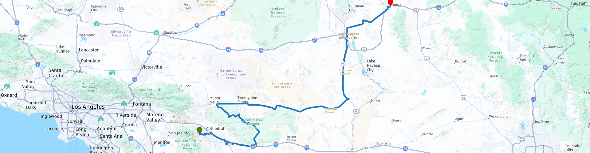
R02 Palm Springs Kingman

This route was brought to you by:
RouteXpert Hans van de Ven (Mr.MRA)
Last edit: 08-04-2021
 Route Summary
 During this journey you will travel through the following states: California, Arizona, Utah & Nevada.
The roads are good, the area hilly and dry and the views beautiful, maybe see a Joshua Tree.
Starting point: Best Western Inn at Palm Springs.
End point: Best Western A Wayfarer's Inn.
The route has been made the same for TomTom, Garmin and MyRoute-app Navigation users.
Thanks to Richard & Lisa for the information!
 Share this route


Animation

Verdict


Duration
6h 52m

Mode of travel
Car or motorcycle

Distance
516.07 km

Countries

 RouteXpert Review
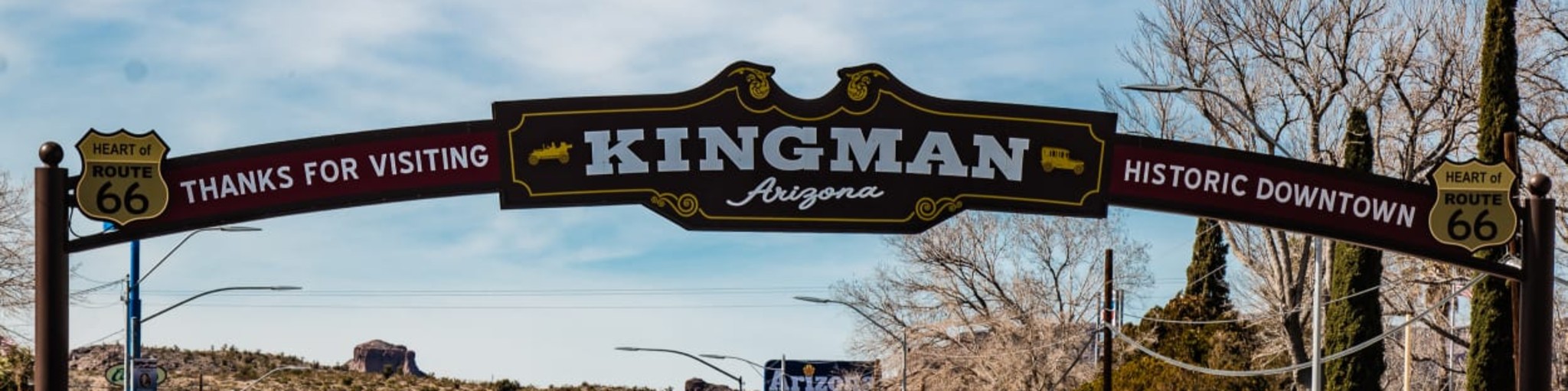
 Kingman is a somewhat smaller town and the hotel is too far away from the Old Town to walk afterwards. You are probably too tired and you arrive quite late to go to the Old Town. Fortunately you can eat well in the hotel and with an outdoor pool with hot tub I am sure you can enjoy yourself.
When leaving Palm Springs you will see how many golf courses there are, you go via Interstate 10 towards the Joshua Tree National Park. After an hour's drive we arrive at the entrance of the Joshua Tree National Park. It is advisable to buy an entrance ticket for all national parks here, costs around $ 80, paying all entrance separately is much more expensive. The Joshua Tree National Park is about 100 km from east to west and 50 km from north to south and is characterized by two completely different desert landscapes: The low Colorado desert in the southeast (where natural gardens grow with Opuntia and scrub among others) and the higher altitude, more humid and slightly cooler Mojave desert. We will mainly drive through this area, because the Joshua Tree grows here, which gives the park its name. When you leave the park, there is a stop in Joshua Tree, for lunch and refueling, as a small 170 km of desert awaits you. Via the Mohave Valley you drive to Vidal, where you can refuel again and stretch your legs.
Then you go through the town of Needles where you cross the Colorado River and enter California from California. You continue your way through the town of Oatman to drive over a portion of the historic Route 66 to Kingman. You drive over the Sitgreaves Pass, this mountain pass is 1,082 meters high and is located in the Black Mountains of Mohave County. Take your time, it's worth the drive. See if you see the old cars next to the hairpin bend. The road is great with so many curves
In this 4-star route you will drive on beautiful good roads, through very dry surroundings where you regularly have to stop for a drink. Take enough water with you!
General information:
The Joshua Tree National Park has an area of approximately 2260 km 2. There are amazing geological formations and mountain ranges that rise from the low valleys to an altitude of 1600 meters.
Numerous impressive plant species grow in the park, including the Joshua tree - from which the park takes its name -, cactus trees, paloverdes, pinon pains, Mojave yuccas and a wealth of multicolored wild flowers. The Joshua tree got its name from Mormon immigrants who thought the branches of the tree looked like arms that reached to heaven in prayer. Many species of animals also live in this desert landscape, such as bighorn sheep, which can be found throughout the park.
In the Oasis Visitor Center, in the city of Twentynine Palms, you will find a map of the park, as well as information about the flora, fauna and history of this fascinating landscape. Key's View, at an altitude of 1660 meters, offers a spectacular view of the desert. On clear days you can see the Salton Sea on the horizon.
Other highlights include the Hidden Valley ("the Hidden Valley") which was reportedly the secret hiding place of a notorious cattle thief and the Lost Horse Mine, a historic gold mine. Please note: there is an entrance fee for the park. Joshua Tree is 225 km southeast of Los Angeles. This area received the National Monument status in 1936. In 1994 it received the status of National Park.
According to the believers among us, the park would be used as a land location for UFOs. At least there are quite a few people who claim this. Photographs of UFOs were also reported to have been made, however, no hard evidence was ever found for these statements. Incidentally, it does not rain a lot in this area, but if it does, the water will also fall from the sky.
Kingman, founded in 1880 during railroad construction in the region, is located in the heart of the Mojave province. Today, the city takes honor and glory from the fact that it is the most important stop on a very long section of the former Route 66.
Due to the unique location of the city, at the intersection of Interstate 40 and US-93, the city often serves as a gateway to the nearby lakes Mead, Mojave and Havasu.
According to a local legend, spirits from surrounding areas roamed in this former gold digger community. The best known city is Oatman, the former headquarters of the mining towns that flourished towards the end of the 19th and early 20th centuries. Many original buildings are still intact and are an attraction for both film producers and visitors looking for the textbook example of a "ghost town." Oatman can be reached via Route 66.
In this area you will also find the Mojave Museum of History and Arts, which is known for a collection of art pieces with pictures of the history of north-western Arizona. There are collections of Native American jewelry (especially turquoise) and even reconstructions of Mojave homes. The Mojave Museum is located at 400 West Beale Street, 500 meters southeast of US-93, exit 1-40.


 Links
Links  Usage
Usage Want to download this route?
You can download the route for free without MyRoute-app account. To do so, open the route and click 'save as'. Want to edit this route?
No problem, start by opening the route. Follow the tutorial and create your personal MyRoute-app account. After registration, your trial starts automatically.  Disclaimer
Use of this GPS route is at your own expense and risk. The route has been carefully composed and checked by a MyRoute-app accredited RouteXpert for use on TomTom, Garmin and MyRoute-app Navigation.
Changes may nevertheless have occurred due to changed circumstances, road diversions or seasonal closures. We therefore recommend checking each route before use.
Preferably use the route track in your navigation system. More information about the use of MyRoute-app can be found on the website under 'Community' or 'Academy'.