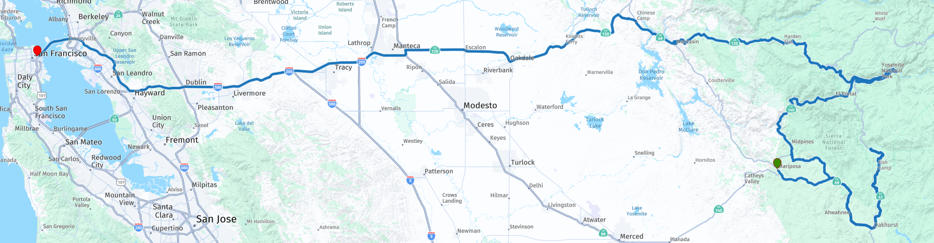
R12 Mariposa San Francisco

This route was brought to you by:
RouteXpert Hans van de Ven (Mr.MRA)
Last edit: 01-02-2020
 Route Summary
 Again a somewhat longer route, so leave on time to properly take in this California treasure chest. It is full of granite mountains, waterfalls and towering redwoods.
During this journey you will travel through the following states: California, Arizona, Utah & Nevada.
The roads are good, the views amazing. No shortage of bends and (giant) trees. A route where you can have a nice picnic along the way, don't forget to do the shopping!
Starting point: Mariposa Lodge.
End point: The Pickwick Hotel.
The route has been made the same for TomTom, Garmin and MyRoute-app Navigation users.
Thanks to Richard & Lisa for the information!
 Share this route


Animation

Verdict


Duration
6h 21m

Mode of travel
Car or motorcycle

Distance
426.28 km

Countries

 RouteXpert Review
 The Yosemite National Park is central to this route, with four million visitors a year, Yosemite is one of the most visited National Parks in the US, and rightfully so. The park is located in the Sierra Nevada mountain area that even the very first Americans considered to be a national treasure because of its beauty. Already in 1864 the land was set aside for nature, but it was not until 1890 that it acquired the status of National Park - which nevertheless made Yosemite one of the first National Parks.
The park was (and still is) formed over millions of years. It started 500 million years ago as an ocean floor and was slowly but surely pushed up to a hilly area. Three million years ago came the glaciers, who put enormous pressure on the landscape and thus created the steep mountains. Only 10,000 years ago did the last ice melt in the park to form Lake Yosemite. This lake was again filled with crumbling rocks and other sediments and thus formed the foundation for the current Yosemite.
In Yosemite you can find high mountains, deep valleys, ancient forests, beautiful meadows and large waterfalls. In addition, the park offers a very diverse flora and fauna, with some unique plant and animal species. In addition to wolves, falcons, deer, bears and squirrels, there are the famous, huge Sequoia trees, which are between 1000 and 3000 years old.
Most areas of the park are accessible by car, but of course it remains largely wild nature. There are many hiking trails, but also mountain climbers, fishermen and ski enthusiasts can enjoy themselves in Yosemite. Camp sites can be found everywhere in the park, usually without electricity but with basic facilities such as
toilets and showers. Most of these camping places are open throughout the year; advance reservation is required.
In this 4 star route you mainly drive on good roads, one or more stops in the Yosemite National Park you should definitely do. Take some food and drinks with you on the road!
General information:
People have lived on San Francisco for centuries. The Spaniards founded the first trading post there in 1776. They tried to convert the Ohlone Indians who lived in the area between present-day San Francisco and Big Sur. This did not always go without violence.
Around 1850 gold was discovered in the Sierra Nevada, the mountains in eastern California. Gold diggers of all nationalities flooded the city and crime reigned supreme: brothels, casinos and opium tents made good money. The explosive growth of the mining industry continued until 1879. Rich in gold and silver finds, the miners built beautiful villas in San Francisco. Thousands of Chinese coolies built the first railway line. Many of these Chinese people continued to live in the city and laid the foundation for Chinatown. The Californian Gold Rush has made San Francisco the business and financial center of the west coast. The Bank of America, for example, was established in San Francisco.
Cable cars were introduced in the nineteenth century. The first trams were pulled over the hills by four horses. An accident, in which one of the horses fell and the entire team crashed, was the reason for modernization. Engineer Andrew S. Hallidie developed the 'cable car', a tram pulled by a cable system. The first tram ran on August 2, 1873 and it can still be used today.
Around 1900, the city was hit six times by an earthquake. The most devastating was the earthquake of 1906. After the quake, a sea of fire arose that lasted three days. Three-quarters of the city (28,000 buildings) were destroyed and around 250,000 people became homeless.
In the Second World War, San Francisco became an important port of war after the bombing of Pearl Harbor (Hawaii). The command center for the Pacific Ocean area settled in the city. After the war, California developed into the most important agricultural state in America and trade in the city flourished vividly. There was a huge influx of emigrants from Asia.
The Monterey Pop Festival and the Summer of Love were highlights of the hippie movement in the 1960s. In 1967 a protest movement was formed at the University of Berkely against the Vietnam War in which America was involved. For homosexuals, San Francisco was already the city where they were welcome, gathered and felt at home. Today, the Castro neighborhood (Eureka Valley) is the heart of San Francisco's gay community. In the seventies of the last century arose in Silicon Valley, the center of the computer industry, just south of the city.
San Francisco was hit again by a major earthquake on October 17, 1989. Fortunately there were fewer victims this time. Many residents will remember the collapse of the double-deck Bay Bridge as a result of this earthquake.


 Links
Links  Usage
Usage Want to download this route?
You can download the route for free without MyRoute-app account. To do so, open the route and click 'save as'. Want to edit this route?
No problem, start by opening the route. Follow the tutorial and create your personal MyRoute-app account. After registration, your trial starts automatically.  Disclaimer
Use of this GPS route is at your own expense and risk. The route has been carefully composed and checked by a MyRoute-app accredited RouteXpert for use on TomTom, Garmin and MyRoute-app Navigation.
Changes may nevertheless have occurred due to changed circumstances, road diversions or seasonal closures. We therefore recommend checking each route before use.
Preferably use the route track in your navigation system. More information about the use of MyRoute-app can be found on the website under 'Community' or 'Academy'.