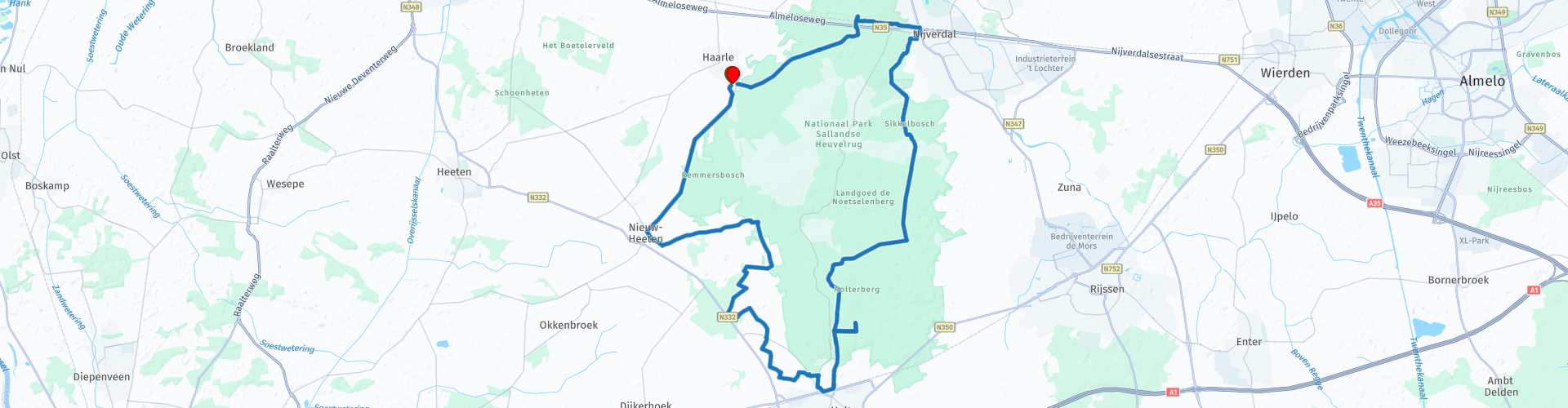
Rondrit Haarle Via Holten en Canadese begraafplaats

Diese Route wurde erstellt von:
RouteXpert Hans Lamers - RouteXpert
Letzte Änderung: 20-10-2023
 Routenzusammenfassung
 Eine wunderschöne Reise über den Sallandse Heuvelrug. Sie können die wunderschöne Natur und die wunderschöne Umgebung genießen.
Da die Route größtenteils durch die Wälder des wunderschönen Sallandse Heuvelrug verläuft, erhält sie eine Bewertung von 4 Sternen.
 Diese Route teilen


Animation

Urteil


Dauer
4h 17m

Reisemodus
Fahrrad

Entfernung
35.50 km

Länder

 RouteXpert-Überprüfung
 Der Start erfolgt bei „Erve de Pas“ am Rande des Salland-Dorfes Haarle.
Bei Erve De Pas können Sie sich auf dem Bauernhof der Vergangenheit wiederfinden. Der Herberg stammt aus dem Jahr 1891 und wurde stilvoll restauriert, wobei die alten Details und Fachwerke erhalten blieben. Hier können Sie eine Tasse Kaffee mit handwerklichem Gebäck, ein köstliches regionales Mittagessen, Getränke oder ein Wirtshausessen genießen.
Die alten Ställe und das Gasthaus
Der alte Pferdestall gegenüber dem Gasthof wird für Tagungen und Schulungen genutzt. Der Informationsschuppen von Natuurmonumenten befindet sich im ehemaligen Schweinestall neben dem Gasthaus. Hier werden unterhaltsame, lehrreiche Workshops und Aktivitäten organisiert.
Der Bauernhof „de Pas“ lag früher auf der anderen Seite der unbefestigten Straße. Damals war es ein Gasthaus. Die Überlieferung besagt, dass Louis Napoleon dort mit einem Konvoi auf dem Weg nach Twente übernachtete. Dieser unbefestigte Weg, ein Pass zwischen den beiden Königsgürteln, verlief über den Berg nach Rijssen, der sogenannte „Weberpfad“.
In der alten Scheune neben dem Gasthaus wurde ein drittes Pferd für die beschwerliche Fahrt über den unbefestigten Feldweg an die Postkutsche gespannt. Das Gasthaus befand sich an einem wichtigen Punkt, einer Kreuzung der Straßen nach Deventer, Raalte, Hellendoorn und Twente. Allerdings brannte das Gasthaus nieder; Die beiden Linden vor der Fassade weisen noch die Spuren in ihren halb verbrannten Stämmen auf. Die große Linde hinter dem Haus wurde verschont und steht noch da. Mit dem Abbrennen des Gasthauses beginnt im De Pas ein neues Stück Geschichte. Das heutige Hauptgebäude wurde 1891 erbaut.
Die Route führt zunächst am Denkmal für den Überfall vom 14. Oktober 1944 vorbei. Das Denkmal besteht aus einem großen Findling mit einer Bronzetafel und einem Schwarz-Weiß-Foto. Neben dem Felsbrocken befindet sich ein zweiter kleinerer Felsbrocken, auf dem eine Bronzetafel und zwei Schwarz-Weiß-Fotos angebracht sind. Damit wird an drei Opfer erinnert, die während des Zweiten Weltkriegs bei dem Luftangriff am 14. Oktober 1944 von den Deutschen ermordet wurden.
Die Opfer waren Marinus Stevens, der Widerstandskämpfer Gerrit Jan Piksen und der jüdische Untergetauchte Maurits Bachrach.
Folgt man dem Weg links neben dem Denkmal, findet man nach etwa 500 Metern rechts eine Versteckhütte aus dem Zweiten Weltkrieg. Wo sich dieser befindet, ist durch ein Schild gekennzeichnet. In diesem Versteck in den Wäldern bei Holten waren während des Zweiten Weltkriegs mehrere Untergetauchte untergebracht, darunter niederländische Männer, die vor dem deutschen Arbeitseinsatz geflohen waren.
(Quelle: Spuren des Krieges).
Da die Versteckhütte gut gepflegt ist, kann man alles in und um die Versteckhütte gut überblicken.
Nach etwa 10 Kilometern können Sie im Streichelzoo Dondertman eine Tasse Kaffee genießen. Dies wird von der Dondertman Children's Farm Foundation betrieben. Der Streichelzoo wurde von Freiwilligen aufgebaut. Der erhöhte Andrang hat mittlerweile zu einer teilweisen Professionalisierung geführt. Hier können Sie eine Tasse Kaffee oder einen anderen Snack genießen.
Nach dem Kaffee können Sie die wunderschöne Natur genießen, die Ihnen der Sallandse Heuvelrug zu bieten hat. Nur einen Steinwurf entfernt passieren Sie den Kanadischen Friedhof Holten. Es lohnt sich auf jeden Fall, hier vorbeizuschauen (er ist in der Route enthalten).
Es ist ein Stück Kanada auf dem Holterberg. Der „Kanadische Holtenfriedhof“ auf dem Holterberg ist eine eindrucksvolle Erinnerung an den Zweiten Weltkrieg. Im Frühjahr 1945, nach fünf Jahren der Unterdrückung, befreiten (überwiegend) kanadische Truppen die nördlichen und östlichen Niederlande. Die niederländische Regierung stellte Land zur Verfügung, um den 1.394 gefallenen Soldaten eine letzte Ruhestätte zu bieten.
Im angeschlossenen Informationszentrum halten wir mit persönlichen Geschichten, Anekdoten und Fotos die Erinnerung an die gefallenen Soldaten wach. Sehen Sie sich im Kino einen Eindruck von der Befreiung der nördlichen und östlichen Niederlande an, erfahren Sie Hintergrundinformationen zum Friedhof und lauschen Sie beeindruckenden Geschichten über die gefallenen Befreier. An den Informationstischen erfahren Sie noch mehr über die Befreiung und unsere Befreier.
Nach diesem beeindruckenden Besuch führt Sie die Route entlang des Goudzoekerspad.
Auf dem Sallandse Heuvelrug wird es nie langweilig. Nicht jetzt und nicht damals. Ihnen fallen keine Namen ein wie „Het Goudzoekerspad“ für einen Radweg, „Gouden Bergen“ für einen Campingplatz und „Alaska“ für ein Haus aus dem Nichts … Wir möchten Sie gerne in das Jahr 1901 zurückversetzen. Die tiefliegende Eisenbahnlinie in der Nähe von Nijverdal – im Volksmund auch Schlucht genannt. Die steilen Sandhänge deuten darauf hin, dass sich möglicherweise Gold im Boden befindet.
Am 12. Januar 1902 begannen 25 Arbeiter mit der Arbeit. Sie legten Gräben mit einer Tiefe von etwa 12 m an. Aus verschiedenen Bodenschichten wurden Proben entnommen und an Labore geschickt. Zunächst schien es eine Erfolgsgeschichte zu sein. Die Proben enthielten Gold, aber das Ergebnis machte es mehr als wahrscheinlich, dass diese Menge keinen kommerziellen Wert hat. Die Schützengräben und Gräben wurden geschlossen, die Arbeiter entlassen. Nur ein Radweg durch die Schlucht, der Weg der Goldsucher, erinnert uns noch an diese glorreichen Monate der Geschichte von Nijverdal.
Am Ende des Weges dieses Goldsuchers müssen Sie vorsichtig sein. Sie stehen dann vor einer stark befahrenen Straße, der N35. Diese müssen Sie überqueren, um die Route fortzusetzen. Die letzten Kilometer der Route führen durch ein wunderschönes Waldgebiet. Die gut ausgebauten Wege führen Sie zurück zum Ausgangspunkt (Erve de Pas).
Im Sommer können Sie hier auch ein köstliches Mittagessen oder eine schöne Tasse Kaffee genießen.
Zusätzliche Informationen zur Vererbung des Pas:
Van Wulfften Palthe kaufte 1898 bei einem Verkauf in Raalte Hunderte Hektar Brachland auf dem Sprengenberg. Er gelangte auch in den Besitz der Farm „De Pas“. Ein paar Mal kam ein anderer Bauer zu uns. Nach seinem Kauf baute Van Wulfften Palthe die Farm von einem Hallenhaus in ein Schemelhaus um, indem er den weißen Teil direkt davor baute. Auf den schönen grünen Fensterläden sehen wir runde Sanduhren in Rot und Gelb, den Farben von Huis Sprengenberg (Palthetoren). Im Jahr 1905 wurde gegenüber dem Hof ein Tiefstall für Jungvieh errichtet. Wenig später, im Jahr 1932, wurde ein Schweinestall angebaut, der heute als Informationsschuppen von Natuurmonumenten dient.


 Links
Links  Nutzung
 Möchten Sie diese Route herunterladen?
Sie können die Route ohne MyRoute-App-Konto kostenlos herunterladen. Öffnen Sie dazu die Route und klicken Sie auf 'Speichern unter'. Möchten Sie diese Route bearbeiten?
Kein Problem, starten Sie mit dem Öffnen der Route. Folgen Sie dem Tutorial und erstellen Sie Ihr persönliches MyRoute-App-Konto. Nach der Registrierung startet Ihre Testversion automatisch.  Haftungsausschluss
Die Nutzung dieser GPS-Route erfolgt auf eigene Kosten und Gefahr. Die Route wurde sorgfältig von einem MyRoute-App akkreditierten RouteXpert für die Verwendung mit TomTom, Garmin und MyRoute-App Navigation zusammengestellt und geprüft.
Durch geänderte Umstände, Straßenumleitungen oder saisonale Sperren können sich dennoch Änderungen ergeben haben. Wir empfehlen daher, jede Route vor der Nutzung zu überprüfen.
Verwenden Sie vorzugsweise den Routentrack in Ihrem Navigationssystem. Mehr Informationen zu den Die Nutzung der MyRoute-App finden Sie auf der Website unter 'Community' oder 'Academy'.

Provinz Overijssel
Über diese Region
Overijssel (; niedersächsisch Oaveriessel, deutsch Oberyssel) ist eine Provinz in den Niederlanden. Sie liegt zwischen dem IJsselmeer, der IJssel und den Hügeln der Veluwe im Westen, Drenthe im Norden, den deutschen Bundesländern Niedersachsen und Nordrhein-Westfalen im Osten und dem Achterhoek (Provinz Gelderland) im Süden. Die Ortsdialekte werden dem Niedersächsischen (Plattdeutsch) zugerechnet.
Die Provinz besteht aus einem Geestgebiet, das von Flüssen und Bächen durchschnitten wird. In der Mitte gibt es bewaldete Hügel von 40 bis 85 Metern Höhe, im Nordwesten erstrecken sich Polder.
Lesen Sie mehr auf Wikipedia
Die Provinz besteht aus einem Geestgebiet, das von Flüssen und Bächen durchschnitten wird. In der Mitte gibt es bewaldete Hügel von 40 bis 85 Metern Höhe, im Nordwesten erstrecken sich Polder.
Region anzeigen
 Statistik
  98
98Anzahl der RX-Bewertungen (Provinz Overijssel)
 57118
57118Anzahl der Besucher (Provinz Overijssel)
 17475
17475Anzahl der Downloads (Provinz Overijssel)
 Routensammlungen in dieser Region
 Die 10 schönsten Auto- und Motorradrouten in den Niederlanden
Diese 10 Routen in den Niederlanden wurden von einem MyRoute-App RouteXpert sorgfältig ausgewählt, geprüft und für TomTom, Garmin und MyRoute-App Navigation gleichgestellt. Die 10 schönsten Motorrad- und Autorouten in den Niederlanden sind immer eine Momentaufnahme und eine persönliche Meinung des Rezensenten. Das ändert nichts daran, dass jeder Liebhaber schöner Straßen und interessanter Sehenswürdigkeiten diese Strecken genießen wird.
Die zehn Routen verteilen sich auf 10 Provinzen, wir haben nur Flevoland und Südholland übersprungen. Interessante Routen finden sich auch in der MyRoute App RouteXpert Bibliothek, wir wollen aber trotzdem bei den 10 schönsten bleiben und nicht bei den 12 schönsten.
Genießen Sie die vielen Festungen und Schlösser, die in den Routen enthalten sind, wie zum Beispiel Fort Veldhuis in Nordholland. Werfen Sie aber auch einen Blick auf die Route südöstlich von Nijmegen und besuchen Sie den beeindruckenden Canadian War Cemetery and Memorial. Die Route 'Overijssel aus der Vogelperspektive' beinhaltet das älteste Haus der Niederlande und die Route entlang der IJssel ist wahrscheinlich das schönste Stück Asphalt der Niederlande.
So ist in dieser Routensammlung für jeden etwas dabei. Wenn Sie mit diesen 10 Routen nicht einverstanden sind, senden Sie uns bitte eine E-Mail, geben Sie an, welche Route(n) entfernt werden sollen und welche Route Sie stattdessen sehen möchten. Vielleicht wird Ihre Route in diese Sammlung der 10 schönsten Routen der Niederlande aufgenommen!
E-Mail: info@myrouteapp.com
Routensammlung anzeigen
Die 10 schönsten Auto- und Motorradrouten in Friesland
Friesland offiziell, Friesisch: Fryslân ist eine Provinz im Norden der Niederlande. Friesland hatte 2018 660.560 Einwohner. Die Hauptstadt ist Leeuwarden. Neben Niederländisch hat Friesisch den Status einer Verwaltungssprache in der Provinz. Aber wer kennt Friesland nicht von der Elfstedentocht? Ein Eislauf-Festival ohnegleichen, leider ist es schon lange her, dass die letzte Elfsteden-Tournee in Friesland stattfand, genauer gesagt am 4. Januar 1997.
Nicht nur Ihre eigene Sprache und eine Skating-Tour entlang der 11 friesischen Städte, sondern auch eine sehr schöne Provinz, um mit dem Auto oder Motorrad zu fahren und all die Schönheiten zu genießen, die die Provinz Friesland zu bieten hat. Zu diesem Zweck hat eine MyRoute App RouteXpert eine Top 10 der Auto- und Motorradrouten für Sie zusammengestellt.
Alle Routen in dieser Sammlung wurden von einer MyRoute-App RouteXpert für TomTom, Garmin und MyRoute-App Navigation geprüft und gleichgestellt.
Wenn Sie denken, ich habe eine sehr schöne Route, die in dieser Sammlung auf keinen Fall fehlen darf, senden Sie sie an:
E-Mail: routeexpert@myrouteapp.com
Betreff: Neue Route für die Top 10 Sammlung Provinz Friesland zusammengestellt von Hans van de Ven.
Die Route wird dann überprüft und in die Top 10 aufgenommen.
Um die Top 10 auch zu den Top 10 zu machen, muss 1 Route aus den Top 10 verschwinden, Sie können dies beim Einreichen der neuen Route angeben.
Viel Spaß mit dieser Sammlung und beim Fahren einer dieser Strecken. Genießen Sie die Schönheit der Niederlande und insbesondere der Provinz Friesland. Klicken Sie auf „Route anzeigen“, um die Bewertung der ausgewählten Route zu lesen.
Ich würde gerne Ihre Erkenntnisse über die Route(n) hören.
Routensammlung anzeigen