Day 02 TCH Nanaimo to Hope

Questo percorso è stato creato da:
RouteXpert René Plücken (MRA Master)
Ultima modifica: 16-11-2025
 Riepilogo percorso
 Questa è la seconda parte che va dalla Vittoria alla Speranza.
La Trans-Canada Highway attraversa tutte le province meridionali del Paese. Il percorso può essere percorso in vari modi, poiché esistono diversi percorsi alternativi che fanno parte della Trans-Canada Highway. La distanza totale è di circa 8.000 km. Non percorreremo esclusivamente la Trans-Canada Highway, ma percorreremo il maggior numero possibile di strade secondarie del Paese, poiché guidare in autostrada da solo è troppo noioso e il Canada vanta numerose strade meravigliose che attraversano paesaggi mozzafiato.
Attraverserai tutte le province e i paesaggi più vari e pittoreschi, dalle Montagne Rocciose a ovest, alle Praterie Centrali, alle Marittime orientali e alle foreste settentrionali.
La stagione equestre va generalmente da aprile a ottobre, con periodi più lunghi sulla costa occidentale e nel sud dell'Ontario.
Assicuratevi di avere un abbigliamento adatto a tutte le stagioni o di portare con voi un impermeabile. A seconda della provincia e della stagione, il meteo può cambiare improvvisamente e potreste essere sorpresi da un acquazzone, o persino da una nevicata o grandine, quindi siate preparati.
In Canada si utilizza il sistema metrico, quindi la velocità è indicata in km/h. Il casco è obbligatorio in tutto il Canada (approvato dal Dipartimento dei Trasporti).
In tutto il Canada, potrete osservare una grande varietà di animali selvatici. Animali simili variano da provincia a provincia, tra cui cervi, bufali, alci, caribù, lupi, puma, orsi, stambecchi, pecore, linci, coyote, volpi, procioni, tassi, vari roditori e una varietà di uccelli.
Anche se è molto allettante fermarsi per una foto, non fatelo: può essere molto pericoloso.
Questa seconda tappa della Trans Canada Highway è classificata a 4**** stelle, è un percorso meraviglioso con viste mozzafiato e un buon numero di attività e attrazioni lungo il percorso.
 Condividi questo percorso


Animation

Verdetto


Durata
8h 6m

Modalità di viaggio
Auto o moto

Distanza
288.77 km

Paesi

 Revisione RouteXpert
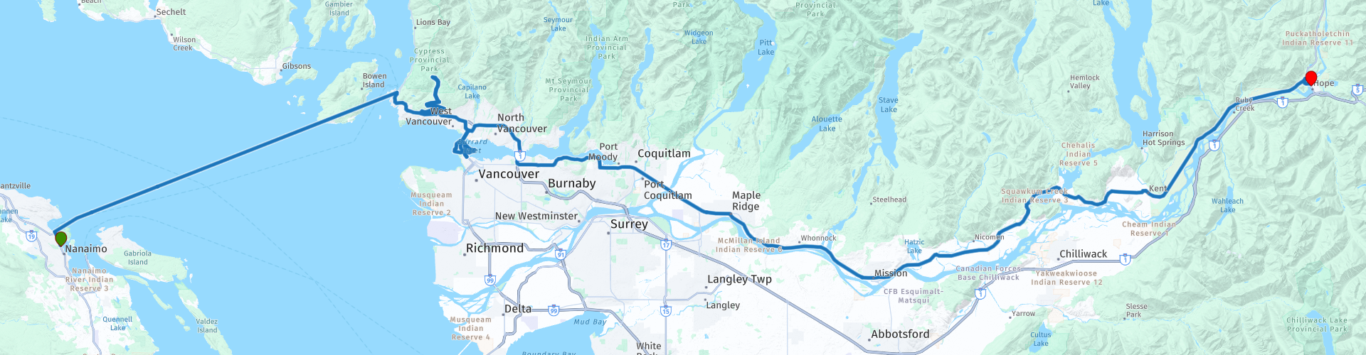
 Il sole mattutino si riflette sull'acqua di Nanaimo mentre accendiamo il motore e ci dirigiamo verso il traghetto. L'avventura ci chiama. Davanti a noi c'è il traghetto di Horseshoe Bay, una traversata di poco più di un'ora e mezza che non solo ci porta sulla terraferma, ma ci offre anche un primo assaggio della grandiosità della Columbia Britannica. Mentre la barca fende dolcemente l'acqua, si apre un panorama di montagne che si ergono come sentinelle sulla baia. Non si tratta di un viaggio qualunque: è un viaggio nel cuore della costa occidentale del Canada.
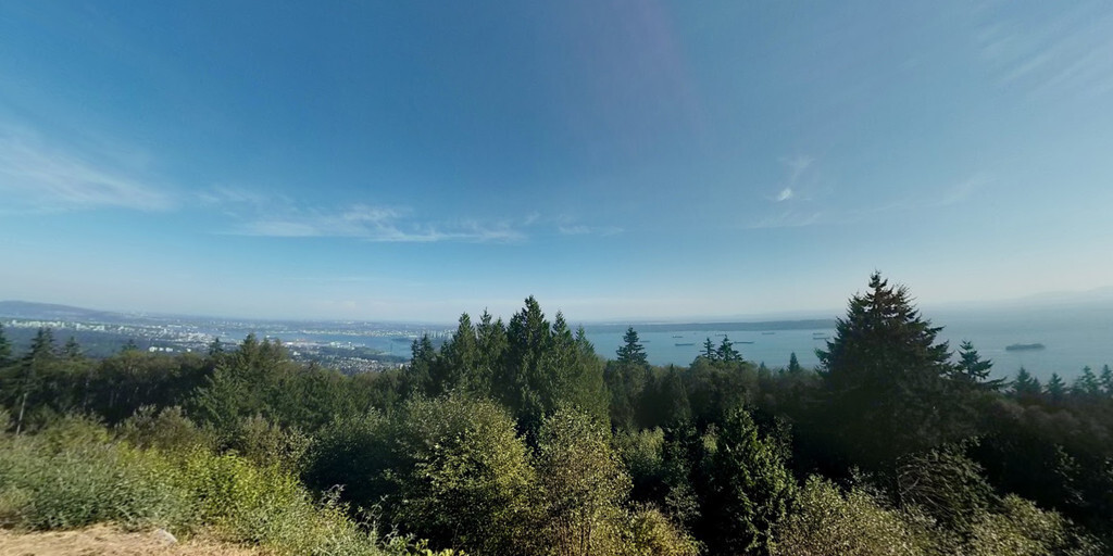
Una volta scesi a terra, nella Horseshoe Bay, inizia il vero lavoro. Imbocchiamo la Trans-Canada Highway, ma presto una strada secondaria ci chiama: Cypress Mountain. La strada sale ripida, serpeggiando attraverso una serie di tornanti. Ci fermiamo brevemente per ammirare il panorama: davanti a noi si estende Vancouver, una città scintillante al sole, circondata da acqua e montagne. Il panorama è mozzafiato, un momento da ricordare.
Di nuovo in viaggio, ci attende un'icona: il Lions Gate Bridge. Questo elegante ponte sospeso, inaugurato nel 1938, attraversa Burrard Inlet. Mentre lo attraversiamo, i leoni di cemento ci sfiorano, silenziosi testimoni di quasi un secolo di storia. Dall'altra parte ci aspetta Stanley Park, un'oasi verde di 400 ettari nel cuore della città. Parcheggiamo e ci lasciamo trasportare dalla magia del parco: sentieri nella foresta pluviale, spiagge, montagne e viste sull'oceano. Il più grande acquario del Canada ci attrae, ma optiamo per il pranzo in uno degli accoglienti ristoranti. Qui, tra il profumo dei pini e il suono dell'oceano, Vancouver sembra una città che intreccia perfettamente natura e cultura.
Dopo questa pausa, torniamo al Lions Gate Bridge, lasciandoci la città alle spalle. La strada ci porta all'Iron Workers Memorial Bridge, un luogo ricco di storia. Mentre lo attraversiamo, penso ai diciotto operai che persero la vita durante la sua costruzione: un ricordo che conferisce a questo ponte una dimensione in più.
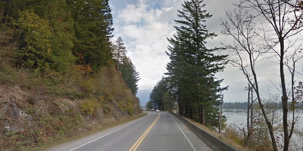
Da Vancouver, non optiamo per la veloce strada TCH lungo la riva sud del fiume Fraser. No, puntiamo all'avventura: la strada settentrionale, che in parte è la Highway BC-7. Qui, la strada si snoda lungo il fiume, su ponti imponenti, con panorami che inducono a fermarsi più volte per una foto. L'acqua luccica, le montagne si stagliano in lontananza: questa è la guida come dovrebbe essere.
Verso sera raggiungiamo Hope, un'incantevole cittadina immersa nella natura. Qui ci aspettano hotel, B&B e un campeggio: un meritato riposo dopo una giornata ricca di emozioni. Mentre il sole tramonta lentamente dietro le montagne, mi rendo conto: questo non è stato solo un viaggio in auto. È un capitolo di una storia più ampia, una storia che continua domani.
 Collegamenti
  Utilizzo
 Vuoi scaricare questo percorso?
Puoi scaricare il percorso gratuitamente senza un account MyRoute-app. Per farlo, apri il percorso e fai clic su 'Salva con nome'. Vuoi modificare questa rotta?
Nessun problema, inizia aprendo il percorso. Segui il tutorial e crea il tuo account MyRoute-app personale. Dopo la registrazione, la tua prova inizia automaticamente.  Disclaimer
L'utilizzo di questo percorso GPS è a tue spese e rischio. Il percorso è stato accuratamente composto e controllato da un RouteXpert accreditato dall'app MyRoute per l'utilizzo su TomTom, Garmin e navigazione dell'app MyRoute.
Ciononostante potrebbero essersi verificati cambiamenti a causa di mutate circostanze, deviazioni stradali o chiusure stagionali. Si consiglia pertanto di controllare ciascun percorso prima dell'uso.
Utilizzare preferibilmente la tracklog del percorso nel sistema di navigazione. Maggiori informazioni sul l'uso dell'app MyRoute può essere trovato sul sito Web in 'Community' o 'Academy'.

Columbia Britannica
Informazioni su questa regione
La Columbia Britannica (in inglese: British Columbia, in francese: Colombie-Britannique) è la più occidentale delle province canadesi. Si affaccia sull'oceano Pacifico ed è stata la sesta provincia in ordine di tempo a unirsi alla confederazione del Canada nel 1871.
Nel 2016, la popolazione ammonta a 4 648 055 persone. Il suo capoluogo è Victoria, città situata sull'isola di Vancouver, mentre la città più popolosa è Vancouver, situata nella parte sud-occidentale della terraferma (e non sull'isola omonima).
Leggi di più su Wikipedia
Nel 2016, la popolazione ammonta a 4 648 055 persone. Il suo capoluogo è Victoria, città situata sull'isola di Vancouver, mentre la città più popolosa è Vancouver, situata nella parte sud-occidentale della terraferma (e non sull'isola omonima).
Visualizza regione
 Statistiche
  15
15Quantità di recensioni RX (Columbia Britannica)
 17014
17014Quantità di visitatori (Columbia Britannica)
 564
564Quantità di download (Columbia Britannica)
 Indirizza le collezioni in questa regione
 Il miglior tour in auto e moto attraverso il Canada, gli Stati Uniti e le Montagne Rocciose
Viaggiare in auto o in moto attraverso il Canada, gli Stati Uniti e le Montagne Rocciose è un viaggio che non si fa, quindi non guidare per 15 giorni e poi tornare a casa. No, prenota un soggiorno di più giorni a Vancouver, Jasper, Banff, Seattle e Port Alberni e ancora Vancouver per visitare anche diversi luoghi di interesse in queste città, in modo che questo tour diventi un tour indimenticabile che puoi ricordare con piacere.
Non dimenticare di organizzare e imballare i seguenti articoli:
*Questo è solo un riepilogo e completamente personale e può variare a persona.
Stipulare un'assicurazione di viaggio, +31 per i numeri in GSM, (parzialmente) prelevare il gas, Assicurazione sanitaria a destinazione?, Spegnere gli apparecchi elettrici, Illuminazione (orologio), Controllare la validità del passaporto, Antenna di radio/TV a causa di fulmini, Indirizzo di residenza per chi è rimasto indietro, Allarme casa telecomandato, Prenota Smart Parking.
Bagaglio a mano:
Liquidi in confezioni da max 100 ml, Liquidi nel bagaglio a mano in busta di plastica trasparente.
Per la strada:
Caramelle, Libro, Tappi per le orecchie, Mappa(e) di paesi e strade, Indicazioni stradali, Mappe nel tuo sistema di navigazione
Denaro e titoli:
Carta bancaria/carta giroscopica, Carta di credito (si pensi al codice pin), Contanti, Calcolatrice per Internet banking, Tessera di assicurazione medica, Tessera di assicurazione di viaggio.
Documenti di viaggio:
Passaporto, patente di guida (internazionale), biglietto(i), biglietti di prenotazione, voucher hotel, orario di arrivo/partenza, orari di check-in e check-out, visto valido (ESTA), guida turistica.
Capi di abbigliamento:
Intimo, Cintura, Camicie/T-shirt, Pantaloncini, Pantaloni lunghi, Scarpe, Calze, Costume da bagno, Asciugamano, Pantofole.
Oggetti personali:
Orologio, chiavi di casa, portafoglio, occhiali da sole.
Articoli da toeletta:
Deodorante, Bagnoschiuma/Sapone, Pettine/spazzola, Attrezzatura da barba, Shampoo, Spazzolino da denti, Dentifricio, Assorbenti igienici
Salute e medicina:
Medicinali propri, Repellente per insetti, Unguento per il raffreddore, Unguento per punture d'insetto, Crema solare, Norit, Paracetamolo, Ventosa per punture di insetti, Borsa di pronto soccorso.
Varie:
Borsa da viaggio/marsupio, Leatherman (= bagaglio da stiva), Penna o matita, Lampada frontale, Accendino, Strumenti ed elettronica, Telefono cellulare e caricatore, Foto/videocamera e caricatore, Scheda/e di memoria, Presa mondiale/adattatore, Ipod e caricabatterie, cavo adattatore iPod, cuffie, iPad e caricabatterie, navigatore e caricabatterie/spina, presa di corrente, batteria Fuelpack.
Motore (accessori):
Casco, abbigliamento da moto, stivali da moto, blocco catena / blocco freno a disco, guanti, bandana, borse interne (borsa della spesa in plastica), borsa isolante, cinghie di tensione, fascette, tuta antipioggia, antipioggia.
Indirizzi:
Elenco indirizzi, numero di telefono dell'ambasciata, numero di telefono per bloccare le carte (bancarie), numero di telefono (biglietti aerei).
Visualizza raccolta percorsi
Autostrada Trans Canada
La Trans-Canada Highway (TCH) o Trans-Canadian Highway è un sistema di autostrade che copre tutte le 10 province del Canada.
Il sistema autostradale federale e provinciale che ora costituisce il TCH fu autorizzato dal Trans-Canada Highway Act del 1948 e aperto nel 1962. Fu completato nel 1971. La lunghezza totale del TCH è di 7821 km.
Contrariamente all'American Interstate Highway System, il TCH non è costituito da una rete inequivocabile di autostrade, ma forma una rete di autostrade ad accesso limitato e altre strade principali che sono più simili alle strade provinciali olandesi. Il percorso è indicato da uno scudo verde con una foglia d'acero bianca.
La numerazione delle strade che fanno parte del TCH è il dominio delle province. Solo le province occidentali hanno allineato la loro numerazione e il TCH ha la denominazione Highway 1 lì.
La rotta principale del TCH inizia a Victoria, nella British Columbia, e attraversa Calgary e Regina fino a Winnipeg. Da Winnipeg il percorso conduce a Kenora in Ontario, dopo di che diversi rami passano dall'Ontario a Ottawa.
Più a est, il percorso passa attraverso la provincia del Quebec attraverso Montreal e Quebec, tra gli altri, fino a Moncton, nel New Brunswick. Quindi il TCH prosegue verso est attraverso la Nuova Scozia, dove un ramo (attraverso il Ponte della Confederazione) conduce all'Isola del Principe Edoardo. Un'altra sezione scende fino al mare nella città portuale di Sydney, dove parte un servizio di traghetti per Channel-Port aux Basques sull'isola di Terranova. Da lì il percorso prosegue per oltre 900 km fino al capoluogo di provincia di San Giovanni, nell'estremo sud-est dell'isola.
Non solo guidiamo la TCH, ma prenderemo le strade rurali il più possibile, perché solo la guida in autostrada è troppo noiosa e il Canada ha molte belle strade attraverso il suo bellissimo paesaggio. Guidi attraverso tutte le province e attraversa paesaggi molto vari e panoramici, dalle Montagne Rocciose a ovest, dalle praterie centrali alle marine orientali e dalla foresta settentrionale.
La stagione delle cavalcate è generalmente da aprile a ottobre, con stagioni più lunghe sulla costa occidentale e nell'Ontario meridionale. Fornisci un buon abbigliamento per tutte le stagioni o porta l'attrezzatura per la pioggia, a seconda della provincia e della stagione il tempo può cambiare e potresti essere sorpreso da una pioggia o persino da una pioggia di neve o grandine, quindi preparati.
In Canada viene utilizzato il sistema metrico, quindi le velocità sono indicate in Km / h. Un requisito di casco (approvato DOT) si applica in tutto il Canada.
Vedrai molti animali selvatici in tutto il Canada. Questo varia da provincia a provincia, come cervi, bufali, alci, caribù, lupi, puma, orsi, capre di montagna, pecore, lince, coyote, volpi, procioni, tassi, vari roditori e tutti i tipi di uccelli. Anche se è molto allettante fermarsi per una foto, non farlo, può essere molto pericoloso.
I percorsi descritti in questa recensione a volte si discostano dalla Trans Canada Highway, portando la lunghezza totale a 9.300 chilometri. I percorsi sono fatti in modo da guidare attraverso le splendide parti del Canada con panorami davvero belli e splendidi luoghi da visitare, questo differisce da musei, parchi a punti storici. I percorsi non sono troppo lunghi, quindi c'è tempo per fermarsi per le foto e le attrazioni lungo il percorso. Puoi anche scegliere di organizzare e combinare le tappe in modo diverso o di aggiungere altri percorsi per abbreviare o prolungare il tuo viaggio. I percorsi sono contrassegnati da un punteggio in stelle, alcuni percorsi sono meno impegnativi o interessanti ma sono necessari per passare al punto successivo, motivo per cui spesso hanno un punteggio inferiore.
Nella descrizione del percorso troverai maggiori dettagli su percorsi e punti di interesse lungo il percorso. Questi punti e anche hotel, ristoranti, stazioni di servizio ecc. Sono indicati con un PDI e talvolta anche con un punto di rotta. Nella descrizione troverai anche collegamenti a siti interessanti e ai percorsi che si collegano a quel giorno.
I percorsi descritti sono;
Giorno 01 TCH Vittoria a Nanaimo
Giorno 02 TCH Nanaimo a Speranza
Giorno 03 TCH Spero di Kamloops
Giorno 04 TCH Kamloops a Revelstoke
Giorno 05 TCH Revelstoke a Lake Louise
Giorno 06 TCH Lake Louise a Calgary
Giorno 07 TCH Calgary to Medicine Hat
Giorno 08 TCH Medicine Hat to Moose Jaw
Giorno 09 TCH Moose Jaw to Regina
Giorno 10 TCH Regina a Brandon
Giorno 11 TCH Brandon a Winnipeg
Giorno 12 TCH Winnipeg a Kenora
13 ° giorno TCH Kenora to Ignace
Giorno 14 TCH Ignace to Thunder Bay
Giorno 15 TCH Thunder Bay a Marathon
Giorno 16 Thunder Bay a Wawa
Giorno 17 TCH Wawa a Sault Ste Marie
18 ° giorno TCH Sault Ste Marie a Espanola
Giorno 19 TCH Espanola a Mattawa
Giorno 20 TCH Mattawa a Ottawa
21 ° giorno TCH da Ottawa a Montreal
22 ° giorno TCH da Montreal al Quebec
23 ° giorno TCH Quebec a Riviere du Loup
24 ° giorno TCH Riviere du Loup a Grand Falls
Giorno 25 TCH Grand Falls a Fredericton
26 ° giorno TCH Fredericton a Moncton
27 ° giorno TCH Moncton a Charlottetown
Giorno 28 TCH Charlottetown a Truro
Giorno 29 TCH Truro a North Sydney
Giorno 30 TCH North Sydney a Corner Brook
Giorno 31 TCH Corner Brook to Grand Falls
Giorno 32 TCH Grand Falls a Clarenville
Giorno 33 TCH da Clarenville a St John.
Divertiti a leggere le recensioni e pianificare il tuo prossimo viaggio.
Se hai guidato questo viaggio, sono molto curioso del tuo feedback!
Visualizza raccolta percorsi