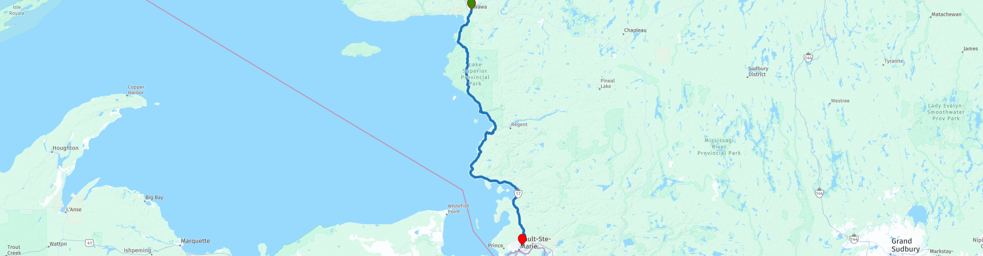
Day 17 TCH Wawa to Sault Ste Marie

Cet itinéraire a été créé par:
RouteXpert René Plücken (MRA Master)
Dernière modification: 09-11-2025
 Résumé de l'itinéraire
 Il s'agit de la section 17 qui s'étend de Wawa à Sault Ste Marie.
La route transcanadienne traverse toutes les provinces du sud du pays. Plusieurs itinéraires alternatifs permettent de l'emprunter. La distance totale est d'environ 8 000 km. Nous ne suivrons pas uniquement la route transcanadienne, mais emprunterons autant que possible les routes secondaires du pays, car rouler uniquement sur l'autoroute est trop monotone, et le Canada offre de nombreuses routes magnifiques qui serpentent à travers des paysages époustouflants.
Vous traverserez toutes les provinces et des paysages très diversifiés et pittoresques, des Rocheuses à l'ouest, aux Prairies centrales, en passant par les Maritimes de l'est et les forêts du nord.
La saison d'équitation s'étend généralement d'avril à octobre, avec des saisons plus longues sur la côte ouest et dans le sud de l'Ontario.
Prévoyez des vêtements adaptés à toutes les saisons ou emportez un imperméable. Selon la province et la saison, le temps peut changer soudainement et vous pourriez être surpris par une averse de pluie, voire de neige ou de grêle ; soyez donc préparé.
Au Canada, le système métrique est utilisé, les vitesses sont donc indiquées en km/h. Le port du casque est obligatoire partout au Canada (homologué DOT).
Partout au Canada, vous pourrez observer une faune abondante. Les espèces similaires varient d'une province à l'autre et comprennent notamment des cerfs, des bisons, des orignaux, des caribous, des loups, des couguars, des ours, des chèvres de montagne, des moutons, des lynx, des coyotes, des renards, des ratons laveurs, des blaireaux, divers rongeurs et une grande variété d'oiseaux.
Même s'il est très tentant de s'arrêter pour prendre une photo, ne le faites pas, cela peut être très dangereux.
Cette excursion est fantastique et mérite amplement 5 étoiles. Elle offre une multitude d'activités et est un vrai plaisir du début à la fin, avec plusieurs arrêts prévus en cours de route. Nous traverserons un magnifique parc naturel et, pour ceux qui le souhaitent, cette journée peut être prolongée d'un ou deux jours afin de profiter pleinement de toute la beauté de ce parc.
 Partager cet itinéraire


Animation

Verdict


Durée
8h 50m

Mode de déplacement
Voiture ou moto

Distance
226.08 km

Pays

 RouteXpert Review
 L'itinéraire d'aujourd'hui vous propose une excursion complète : nature, culture et paysages à couper le souffle. Nous traverserons l'impressionnant parc provincial du Lac Supérieur, une région si riche en attraits qu'on pourrait facilement y passer un jour (ou deux) de plus.
Avant de quitter Wawa, nous faisons le plein et nous approvisionnons en collations et en boissons. Après une quinzaine de kilomètres, nous arrivons à l'entrée du parc provincial du Lac Supérieur. Avec ses 1 550 km² de nature sauvage, c'est l'un des plus grands parcs provinciaux de l'Ontario. Falaises, plages, vallées fluviales, chutes d'eau et d'innombrables lacs intérieurs composent un paysage inoubliable. Tout est bien indiqué par des panneaux bruns et jaunes, et ceux qui le souhaitent peuvent faire de la randonnée, du canoë, de la pêche ou même camper dans l'un des 200 emplacements de camping en pleine nature.
Nos incontournables dans le parc :
• Old Woman Bay, une longue plage de sable fin entourée de falaises de 200 mètres de haut. La vue sur Entrance Island et les eaux du lac Supérieur est à couper le souffle. Idéal pour un pique-nique ou une séance photo.
• Katherine Cove, une crique idyllique avec une petite plage et une eau cristalline. Un endroit où faire une pause et se détendre.
• Les pictogrammes rupestres d'Agawa, l'un des sites archéologiques les plus célèbres du Canada. Vous y découvrirez d'anciennes peintures rupestres ojibwées, des récits oniriques et des visions. Respectez ce lieu sacré : ne touchez à rien, contentez-vous d'admirer.
• Point de vue panoramique de la baie d'Agawa : une vue imprenable sur la baie, idéale pour une photo.
• Centre d'accueil des visiteurs : pour obtenir des renseignements supplémentaires sur le parc et admirer la vue sur l'île de Montréal.
• Barrage de la rivière Montréal : un petit détour pour prendre une photo de l’un des quatre barrages hydroélectriques sur la rivière.
À mi-parcours, nous déjeunerons au Northgate Chip Wagon Plus, où nous dégusterons de délicieux plats faits maison, mais attention : paiement en espèces uniquement !
Après le déjeuner, la route serpente le long de la côte. À travers les arbres, on aperçoit le lac Supérieur et ses baies : la baie Mica, la baie Flour et l’anse Cottrell.
À Pancake Bay, vous pouvez faire le plein, prendre un verre et peut-être déguster un morceau de truite fraîche. Il y a aussi une boutique de souvenirs.
Pour ceux qui souhaitent se détendre sur la plage, le parc provincial de Batchawana Bay offre une magnifique plage de sable fin.
Notre dernière étape est Chippewa Falls, non pas une haute cascade, mais un long et large ruisseau qui serpente jusqu'à la baie. De l'autre côté, vous trouverez un restaurant et une boutique de souvenirs.
Ensuite, nous parcourrons encore 50 kilomètres à travers des rochers, des forêts et des vues imprenables sur la baie de Batchawana avant d'arriver à Sault Ste. Marie, une ville riche en histoire et en nature.
Ma note : ★★★★★. Cinq étoiles pour une étape qui a tout pour plaire : des paysages spectaculaires, un riche patrimoine culturel et une route qui ne cesse de surprendre. Prenez votre temps, arrêtez-vous souvent et savourez chaque kilomètre.
Profitez du voyage !


 Liens
Liens  Utilisation
 Vous voulez télécharger cette route?
Vous pouvez télécharger l'itinéraire gratuitement sans compte MyRoute-app. Pour ce faire, ouvrez l'itinéraire et cliquez sur 'enregistrer sous'. Vous voulez éditer cette route?
Pas de problème, commencez par ouvrir la route. Suivez le tutoriel et créez votre compte personnel MyRoute-app. Après l'enregistrement, votre essai démarre automatiquement.  Avertissement
L'utilisation de cet itinéraire GPS est à vos propres frais et risques. L'itinéraire a été soigneusement composé et vérifié par un RouteXpert accrédité par MyRoute-app pour une utilisation sur TomTom, Garmin et MyRoute-app Navigation.
Des modifications peuvent néanmoins s'être produites en raison de circonstances modifiées, de déviations de routes ou de fermetures saisonnières. Nous vous recommandons donc de vérifier chaque itinéraire avant de l'utiliser.
Utilisez de préférence le tracé de l'itinéraire dans votre système de navigation. Plus d'informations sur le l'utilisation de MyRoute-app peut être trouvée sur le site Web sous 'Communauté' ou 'Académie'

Ontario
À propos de cette région
L'Ontario (/ɔ̃.ta.ʁjo/ ; en anglais : /ˌɑn.ˈtɛə.ɹi.oʊ/) est la province la plus peuplée du Canada, comptant près de 13,5 millions d'habitants en 2016. Elle se trouve dans la partie centre-est du pays et a pour capitale Toronto (également la plus grande ville canadienne), située dans le sud de la province. Vers le sud et le sud-ouest, le territoire de la province partage une longue frontière avec les États-Unis (États du Minnesota, du Michigan, de l'Ohio, de la Pennsylvanie et de New York), dont une grande partie est constituée par les lacs Supérieur, Huron, Érié et Ontario. À l'ouest, la province est bordée par le Manitoba tandis qu'à l'est, elle partage une frontière avec le Québec.
Ottawa, capitale fédérale du Canada, se situe sur son territoire, à la confluence de la rivière des Outaouais. Si le Sud est très urbanisé avec la Golden Horseshoe, le Nord et l'Ouest de la province sont en revanche assez ruraux.
En savoir plus sur Wikipedia
Ottawa, capitale fédérale du Canada, se situe sur son territoire, à la confluence de la rivière des Outaouais. Si le Sud est très urbanisé avec la Golden Horseshoe, le Nord et l'Ouest de la province sont en revanche assez ruraux.
Afficher la région
 Statistiques
  18
18Nombre de critiques RX (Ontario)
 15626
15626Nombre de visiteurs (Ontario)
 558
558Nombre de téléchargements (Ontario)
 Acheminer les collections dans cette région
 Le tour ultime des Grands Lacs
Il s'agit d'une visite de Chicago à Staten Island, New York, visitant les 5 Grands Lacs d'Amérique du Nord.
À partir de la location de moto EagleRider à l'Illinois Harley-Davidson à Chicago et se terminant à la location de moto EagleRider à Staten Island.
La visite ultime des Grands Lacs est une route à travers les États-Unis et le Canada vers des destinations pittoresques le long des lacs Michigan, Supérieur, Huron, Érié et Ontario.
Quels sont les Grands Lacs? Les Grands Lacs sont une série de cinq lacs d'eau douce interconnectés situés à la frontière des États-Unis et du Canada. Ils sont le plus grand groupe de lacs d'eau douce au monde par zone et ont des caractéristiques semblables à la mer telles que des vagues ondulantes, de forts courants, des kilomètres de plages de sable et de rochers et des horizons lointains. Cette visite de 8 itinéraires comprend des arrêts pour prendre un café, déjeuner et passer la nuit dans des hôtels. Il visite également des sites historiques et pittoresques bien connus le long du chemin, évitant principalement les autoroutes principales. J'ai proposé 2 nuits au lac Supérieur et 2 nuits aux chutes du Niagara, ce qui en fait une excursion de 10 jours, mais bien sûr, cela dépend de vous. Le paysage et les paysages sont à couper le souffle et chaque jour est différent du suivant. Amusez-vous.
Afficher la collection d'itinéraires
Transcanadienne
La Transcanadienne (TCH) ou Trans-Canadian Highway est un réseau routier qui couvre les 10 provinces du Canada.
Le réseau routier fédéral et provincial qui forme maintenant le TCH a été autorisé par le Trans-Canada Highway Act de 1948 et ouvert en 1962. Il a été achevé en 1971. La longueur totale du TCH est de 7821 km.
Contrairement à l'American Interstate Highway System, le TCH ne se compose pas d'un réseau sans ambiguïté d'autoroutes, mais forme un réseau d'autoroutes à accès restreint et d'autres routes principales qui s'apparentent davantage aux routes provinciales néerlandaises. L'itinéraire est indiqué par un bouclier vert avec une feuille d'érable blanche.
La numérotation des routes qui font partie de la TCH est du domaine des provinces. Seules les provinces de l'Ouest ont aligné leur numérotation et la TCH porte la désignation Autoroute 1.
La route principale du TCH commence à Victoria en Colombie-Britannique et passe par Calgary et Regina jusqu'à Winnipeg. De Winnipeg, l'itinéraire mène à Kenora en Ontario, après quoi plusieurs succursales passent par l'Ontario à Ottawa.
Plus à l'est, l'itinéraire traverse la province de Québec via Montréal et Québec, entre autres, jusqu'à Moncton, au Nouveau-Brunswick. Ensuite, le TCH continue vers l'est à travers la Nouvelle-Écosse, où une branche (via le pont de la Confédération) mène à l'Île-du-Prince-Édouard. Une autre section descend jusqu'à la mer dans la ville portuaire de Sydney, où un service de traversier part pour Channel-Port aux Basques sur l'île de Terre-Neuve. De là, l'itinéraire continue sur plus de 900 km jusqu'à la capitale provinciale de St. John's, à l'extrême sud-est de l'île.
Nous conduisons non seulement la TCH, mais nous emprunterons autant que possible les routes rurales, car seule la conduite sur autoroute est trop ennuyeuse et le Canada possède de nombreuses belles routes à travers son magnifique paysage. Vous traversez toutes les provinces et traversez des paysages très variés et pittoresques, des Rocheuses de l'Ouest, du Centre des Prairies aux Maritimes de l'Est et de la Forêt du Nord.
La saison d'équitation s'étend généralement d'avril à octobre, avec des saisons plus longues sur la côte ouest et le sud de l'Ontario. Fournissez de bons vêtements toute saison ou apportez des vêtements de pluie, selon la province et la saison, le temps peut changer et vous pourriez être surpris par une pluie ou même une averse de neige ou de grêle, alors soyez prêt.
Au Canada, le système métrique est utilisé, donc les vitesses sont indiquées en Km / h. Une exigence de casque (approuvée par le DOT) s'applique partout au Canada.
Vous verrez de nombreux animaux sauvages à travers le Canada. Cela varie d'une province à l'autre, comme les cerfs, les buffles, les orignaux, les caribous, les loups, les pumas, les ours, les chèvres de montagne, les moutons, les lynx, les coyotes, les renards, les ratons laveurs, les blaireaux, divers rongeurs et toutes sortes d'oiseaux. Même s'il est très tentant de s'arrêter pour une photo, ne le faites pas, cela peut être très dangereux.
Les itinéraires décrits dans cette revue s'écartent parfois de la Transcanadienne, ce qui porte la longueur totale à 9 300 kilomètres. Les itinéraires sont faits pour que vous traversiez les belles régions du Canada avec de très beaux panoramas et de beaux sites à visiter, cela diffère des musées, des parcs et des points historiques. Les itinéraires ne sont pas trop longs, il est donc temps de s'arrêter pour des photos et des sites touristiques le long du chemin. Vous pouvez également choisir d'organiser et de combiner les étapes différemment ou d'ajouter d'autres itinéraires pour raccourcir ou prolonger votre voyage. Les itinéraires sont marqués d'une note en étoiles, certains itinéraires sont moins difficiles ou intéressants mais sont nécessaires pour conduire au point suivant, c'est pourquoi ils ont souvent une note inférieure.
Dans la description de l'itinéraire, vous trouverez plus de détails sur les itinéraires et les points d'intérêt le long du chemin. Ces points ainsi que les hôtels, restaurants, stations-service, etc. sont signalés par un POI et parfois aussi par un point Route. Dans la description, vous trouverez également des liens vers des sites intéressants et vers les itinéraires qui se connectent à cette journée.
Les itinéraires décrits sont;
Jour 01 Victoire du TCH à Nanaimo
Jour 02 TCH Nanaimo à Hope
Jour 03 TCH Hope à Kamloops
Jour 04 TCH Kamloops à Revelstoke
Jour 05 TCH Revelstoke à Lake Louise
Jour 06 TCH Lake Louise à Calgary
Jour 07 TCH Calgary à Medicine Hat
Jour 08 TCH Medicine Hat à Moose Jaw
Jour 09 TCH Moose Jaw à Regina
Jour 10 TCH Regina à Brandon
Jour 11 TCH Brandon à Winnipeg
Jour 12 TCH Winnipeg à Kenora
Jour 13 TCH Kenora à Ignace
Jour 14 TCH Ignace à Thunder Bay
Jour 15 TCH Thunder Bay à Marathon
Jour 16 De Thunder Bay à Wawa
Jour 17 TCH Wawa à Sault Ste Marie
Jour 18 TCH Sault Ste Marie à Espanola
Jour 19 TCH Espanola à Mattawa
Jour 20 TCH Mattawa à Ottawa
Jour 21 TCH Ottawa à Montréal
Jour 22 TCH Montréal à Québec
Jour 23 TCH Québec à Rivière du Loup
Jour 24 TCH Rivière du Loup à Grand-Sault
Jour 25 TCH Grand Falls à Fredericton
Jour 26 TCH Fredericton à Moncton
Jour 27 TCH Moncton à Charlottetown
Jour 28 TCH Charlottetown à Truro
Jour 29 TCH Truro à North Sydney
Jour 30 TCH North Sydney à Corner Brook
Jour 31 TCH Corner Brook à Grand Falls
Jour 32 TCH Grand Falls à Clarenville
Jour 33 TCH Clarenville à St John.
Amusez-vous à lire les critiques et à planifier votre prochain road trip.
Si vous avez conduit ce voyage, je suis très curieux de vos retours!
Afficher la collection d'itinéraires