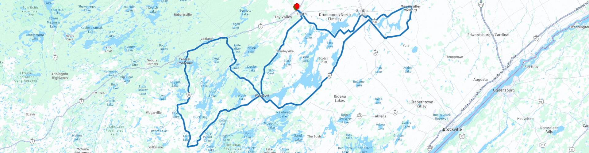
Perth to Rideau Ridge Roundtrip

Diese Route wurde erstellt von:
RouteXpert William Edward Henry
Letzte Änderung: 07-11-2021
 Routenzusammenfassung
 Dies ist eine entspannte Fahrt, die echten Kleinstadtcharme kombiniert mit den Ingenieurleistungen des 19. Jahrhunderts inmitten einer spektakulären Landschaft bietet.
Diese wunderbare Kombination aus interessanten Straßen, angenehmer Landschaft, Kleinstadtcharme und der erstaunlichen Technik des Rideau-Kanals habe ich als Vier-Sterne-Plus-Route bewertet.
 Diese Route teilen


Animation

Urteil


Dauer
6h 55m

Reisemodus
Auto oder Motorrad

Entfernung
253.41 km

Länder

 RouteXpert-Überprüfung
 Der Kanal wurde ursprünglich von der britischen Armee nach dem Krieg von 1812 gebaut. Er wurde im 19. Jahrhundert in erheblichem Maße kommerziell und militärisch genutzt, wurde jedoch beim Bau von Eisenbahnen nicht mehr genutzt. Jetzt ist es eine wunderbare Freizeitwasserstraße, die auf die gleiche Weise wie vor 200 Jahren betrieben wird.
Der Name des Kanals stammt von dem Wasservorhang, der dort gebildet wurde, wo der nördlich fließende Rideau River in den Ottawa River mündet.
Entlang der Route überqueren Sie die Landhöhe zwischen Ottawa und Kingston, über die der Kanal eine schiffbare Wasserstraße zwischen dem Ontariosee und dem Ottawa River bietet. Die Route führt durch mehrere Städte, Schleusenstationen und andere historische Gebäude, die mit dem Kanal verbunden sind.
Wir beginnen unsere Route in Perth am Tay. Ja, die Namen kommen aus Schottland. Die meisten Steinmetze, die beim Bau des Kanals halfen, waren Schotten; Ihr Erbe ist überall in diesem Teil von Ontario zu finden.
Von Perth aus machen wir uns auf den Weg nach Osten zu den Städten Smiths Falls und Merrickville. Beide Städte sind Schleusenstationen am Kanal. In Smiths Falls kann man die modernisierten Schleusen sehen, die von Transport Canada installiert wurden, bevor der Kanal zur historischen Stätte erklärt wurde. In Merrickville sind die verwendeten Schlösser die Originale.
Nehmen Sie sich etwas Zeit, um in Merrickville einen Spaziergang durch die Stadt zu machen. Neben der Schleusenstation gibt es in der Stadt eine Fülle historischer Stätten und mehrere Cafés, in denen Sie sich erfrischen können. Beachten Sie insbesondere die Steinhäuser und andere Gebäude in der ganzen Stadt. Dies ist ein weiteres Erbe der oben genannten Schotten.
Von Merrickville aus fahren wir südwestlich über die Höhe des Landes an Portland vorbei, wo wir die Gelegenheit haben, in einem örtlichen Park eine Pause einzulegen, bevor wir zu einer anderen Schleusenstation in Newboro fahren. In Newboro fließt das Wasser nach Süden nach Kingston; In Smiths Falls und Merrickville fließt Wasser nach Norden nach Ottawa.
Von Newboro aus fahren wir durch Westport, das im 19. Jahrhundert ein wichtiges Handelszentrum war. Seine Lage am Rideau Lake, dem Höhepunkt des Kanals, ermöglichte einen einfachen Warentransport nach Norden nach Ottawa und nach Süden nach Kingston.
Von Westport aus führt die Route über eine große Schleife durch die Landschaft im Osten Ontarios, bevor Sie nach Westport zurückkehren. Für diejenigen mit weniger Ausdauer, die diese Runde verpassen möchten, ist es eine kurze Strecke von Westport zurück nach Perth.
Auf dem Rückweg nach Perth sollten diejenigen mit Energie und starken Beinen im Foley Mountain Conservation Area anhalten und den Aufstieg zum Spy Rock machen. Die Belohnung ist ein herrlicher Blick auf den Rideau Lake und die umliegende Landschaft.
Wir beenden die Fahrt mit einer Rückkehr zum Tay Inn in Perth. Glücklicherweise befindet sich die Perth Brewery direkt neben dem Motel und bietet eine angenehme Auswahl an hochwertigen Craft Brews. Das Abendessen ist nur einen kurzen Spaziergang entfernt im „The Hungry 7 Restaurant“ erhältlich.


 Links
Links  Nutzung
 Möchten Sie diese Route herunterladen?
Sie können die Route ohne MyRoute-App-Konto kostenlos herunterladen. Öffnen Sie dazu die Route und klicken Sie auf 'Speichern unter'. Möchten Sie diese Route bearbeiten?
Kein Problem, starten Sie mit dem Öffnen der Route. Folgen Sie dem Tutorial und erstellen Sie Ihr persönliches MyRoute-App-Konto. Nach der Registrierung startet Ihre Testversion automatisch.  Haftungsausschluss
Die Nutzung dieser GPS-Route erfolgt auf eigene Kosten und Gefahr. Die Route wurde sorgfältig von einem MyRoute-App akkreditierten RouteXpert für die Verwendung mit TomTom, Garmin und MyRoute-App Navigation zusammengestellt und geprüft.
Durch geänderte Umstände, Straßenumleitungen oder saisonale Sperren können sich dennoch Änderungen ergeben haben. Wir empfehlen daher, jede Route vor der Nutzung zu überprüfen.
Verwenden Sie vorzugsweise den Routentrack in Ihrem Navigationssystem. Mehr Informationen zu den Die Nutzung der MyRoute-App finden Sie auf der Website unter 'Community' oder 'Academy'.

Ontario
Über diese Region
Ontario (engl. Aussprache [ɒnˈtʰɛə̯ɹioʊ̯]) ist eine Provinz im Südosten Kanadas. Sie ist die mit Abstand bevölkerungsreichste und nach Québec die flächenmäßig zweitgrößte Provinz des Landes (Nunavut und die Nordwest-Territorien sind zwar größer, gehören jedoch zu den Territorien). Ontario grenzt an die Provinzen Manitoba im Westen und Québec im Osten sowie an fünf US-Bundesstaaten im Süden.
Hauptstadt Ontarios und gleichzeitig größte Stadt des Landes ist Toronto. Ottawa, die Hauptstadt Kanadas, befindet sich im Osten an der Grenze zu Québec. Ottawa gehört zu Ontario, im Gegensatz zu vielen anderen Flächenstaaten existiert kein gesonderter Hauptstadtdistrikt. Bei der Volkszählung 2006 wurden 12.160.282 Einwohner gezählt, was 38,5 % der Bevölkerung Kanadas entspricht.
Lesen Sie mehr auf Wikipedia
Hauptstadt Ontarios und gleichzeitig größte Stadt des Landes ist Toronto. Ottawa, die Hauptstadt Kanadas, befindet sich im Osten an der Grenze zu Québec. Ottawa gehört zu Ontario, im Gegensatz zu vielen anderen Flächenstaaten existiert kein gesonderter Hauptstadtdistrikt. Bei der Volkszählung 2006 wurden 12.160.282 Einwohner gezählt, was 38,5 % der Bevölkerung Kanadas entspricht.
Region anzeigen
 Statistik
  18
18Anzahl der RX-Bewertungen (Ontario)
 15626
15626Anzahl der Besucher (Ontario)
 558
558Anzahl der Downloads (Ontario)
 Routensammlungen in dieser Region
 Die ultimative Great Lakes Tour
Dies ist eine Tour von Chicago nach Staten Island, New York, um die 5 Great Lakes of North America zu besuchen.
Beginnend mit dem EagleRider-Motorradverleih in Illinois Harley-Davidson in Chicago und endend mit dem EagleRider-Motorradverleih in Staten Island.
Die Ultimate Great Lakes Tour ist eine Route durch die USA und Kanada zu malerischen Zielen entlang der Seen Michigan, Superior, Huron, Erie und Ontario.
Was sind die Großen Seen? Die Großen Seen sind eine Reihe von fünf miteinander verbundenen Süßwasserseen an der Grenze zwischen den Vereinigten Staaten und Kanada. Sie sind flächenmäßig die größte Gruppe von Süßwasserseen der Welt und haben meeresähnliche Eigenschaften wie rollende Wellen, starke Strömungen, kilometerlange Sand- und Felsstrände und ferne Horizonte. Diese Tour von 8 Routen beinhaltet Orte, an denen Sie Kaffee, Mittagessen und Übernachtungshotels kaufen können. Es besucht auch bekannte historische und landschaftlich reizvolle Stätten auf dem Weg, wobei hauptsächlich wichtige Autobahnen vermieden werden. Ich habe 2 Nächte am Lake Superior und 2 Nächte an den Niagarafällen vorgeschlagen, was dies zu einer 10-tägigen Tour macht, aber das liegt natürlich bei Ihnen. Die Landschaften und Landschaften sind atemberaubend und jeder Tag ist anders als der nächste. Genießen Sie bitte.
Routensammlung anzeigen
Trans Canada Highway
Der Trans-Canada Highway (TCH) oder Trans-Canadian Highway ist ein Autobahnsystem, das alle 10 Provinzen Kanadas abdeckt.
Das Bundes- und Provinzautobahnsystem, das jetzt das TCH bildet, wurde durch das Trans-Canada Highway Act von 1948 genehmigt und 1962 eröffnet. Es wurde 1971 fertiggestellt. Die Gesamtlänge des TCH beträgt 7821 km.
Im Gegensatz zum amerikanischen Interstate Highway System besteht das TCH nicht aus einem eindeutigen Autobahnnetz, sondern aus einem Netz von Autobahnen mit beschränktem Zugang und anderen Hauptstrecken, die den niederländischen Provinzstraßen ähnlicher sind. Die Route wird durch einen grünen Schild mit einem weißen Ahornblatt angezeigt.
Die Nummerierung der Straßen, die Teil des TCH sind, ist die Domäne der Provinzen. Nur die westlichen Provinzen haben ihre Nummerierung angepasst und der TCH trägt dort die Bezeichnung Highway 1.
Die Hauptstrecke des TCH beginnt in Victoria in British Columbia und führt über Calgary und Regina nach Winnipeg. Von Winnipeg führt die Route nach Kenora in Ontario, wonach mehrere Abzweigungen durch Ontario nach Ottawa führen.
Weiter östlich führt die Route durch die Provinz Quebec über Montreal und Quebec unter anderem nach Moncton, New Brunswick. Dann fährt der TCH weiter nach Osten durch Nova Scotia, wo ein Zweig (über die Confederation Bridge) nach Prince Edward Island führt. Ein weiterer Abschnitt führt in der Hafenstadt Sydney zum Meer hinunter, wo eine Fähre nach Channel-Port aux Basques auf der Insel Neufundland fährt. Von dort führt die Route mehr als 900 km bis zur Provinzhauptstadt St. John's im äußersten Südosten der Insel.
Wir fahren nicht nur den TCH, sondern werden auch so viel wie möglich auf den Landstraßen fahren, da nur das Fahren auf der Autobahn zu langweilig ist und Kanada viele schöne Straßen durch seine wunderschöne Landschaft hat. Sie fahren durch alle Provinzen und durch sehr abwechslungsreiche und landschaftlich reizvolle Landschaften, von den Rocky Mountains im Westen, den Central Prairies bis zu den Eastern Maritimes und dem Northern Forest.
Die Reitsaison dauert in der Regel von April bis Oktober mit längeren Jahreszeiten an der Westküste und im Süden von Ontario. Stellen Sie gute Kleidung für die ganze Saison bereit oder bringen Sie Regenbekleidung mit, je nach Provinz und Jahreszeit kann sich das Wetter ändern und Sie werden möglicherweise von einem Regen oder sogar einer Schnee- oder Hageldusche überrascht. Seien Sie also vorbereitet.
In Kanada wird das metrische System verwendet, daher werden Geschwindigkeiten in km / h angegeben. In ganz Kanada gilt eine Helmanforderung (DOT-genehmigt).
Sie werden viele wild lebende Tiere in ganz Kanada sehen. Dies variiert von Provinz zu Provinz, wie Hirsche, Büffel, Elche, Karibu, Wölfe, Pumas, Bären, Bergziegen, Schafe, Luchse, Kojoten, Füchse, Waschbären, Dachs, verschiedene Nagetiere und alle Arten von Vögeln. Auch wenn es sehr verlockend ist, für ein Foto anzuhalten, tun Sie es nicht, es kann sehr gefährlich sein.
Die in dieser Überprüfung beschriebenen Routen weichen manchmal vom Trans Canada Highway ab und bringen die Gesamtlänge auf 9.300 Kilometer. Die Routen sind so angelegt, dass Sie durch die wunderschönen Teile Kanadas mit wirklich wunderschönen Panoramen und wunderschönen Sehenswürdigkeiten fahren. Dies unterscheidet sich von Museen, Parks bis hin zu historischen Punkten. Die Routen sind nicht zu lang, so dass Sie unterwegs Zeit haben, um Fotos und Sehenswürdigkeiten zu machen. Sie können die Etappen auch anders anordnen und kombinieren oder andere Routen hinzufügen, um Ihre Reise zu verkürzen oder zu verlängern. Die Routen sind mit einer Sternebewertung gekennzeichnet. Einige Routen sind weniger anspruchsvoll oder interessant, müssen jedoch zum nächsten Punkt gefahren werden, weshalb sie häufig eine niedrigere Bewertung haben.
In der Routenbeschreibung finden Sie weitere Details zu den Routen und den Sehenswürdigkeiten auf dem Weg. Diese Punkte sowie Hotels, Restaurants, Tankstellen usw. sind mit einem POI und manchmal auch mit einem Routenpunkt gekennzeichnet. In der Beschreibung finden Sie auch Links zu interessanten Websites und zu den Routen, die mit diesem Tag verbunden sind.
Die beschriebenen Routen sind;
Tag 01 TCH Sieg für Nanaimo
Tag 02 TCH Nanaimo zur Hoffnung
Tag 03 TCH Hoffnung auf Kamloops
Tag 04 TCH Kamloops nach Revelstoke
Tag 05 TCH Revelstoke nach Lake Louise
Tag 06 TCH Lake Louise nach Calgary
Tag 07 TCH Calgary zum Medizinhut
Tag 08 TCH Medizinhut zum Elchkiefer
Tag 09 TCH Moose Jaw nach Regina
Tag 10 TCH Regina nach Brandon
Tag 11 TCH Brandon nach Winnipeg
Tag 12 TCH Winnipeg nach Kenora
Tag 13 TCH Kenora nach Ignace
Tag 14 TCH Ignace nach Thunder Bay
Tag 15 TCH Thunder Bay zum Marathon
Tag 16 Thunder Bay nach Wawa
Tag 17 TCH Wawa nach Sault Ste Marie
Tag 18 TCH Sault Ste Marie nach Espanola
Tag 19 TCH Espanola nach Mattawa
Tag 20 TCH Mattawa nach Ottawa
Tag 21 TCH Ottawa nach Montreal
Tag 22 TCH Montreal nach Quebec
Tag 23 TCH Quebec nach Riviere du Loup
Tag 24 TCH Riviere du Loup nach Grand Falls
Tag 25 TCH Grand Falls nach Fredericton
Tag 26 TCH Fredericton nach Moncton
Tag 27 TCH Moncton nach Charlottetown
Tag 28 TCH Charlottetown nach Truro
Tag 29 TCH Truro nach North Sydney
Tag 30 TCH North Sydney nach Corner Brook
Tag 31 TCH Corner Brook nach Grand Falls
Tag 32 TCH Grand Falls nach Clarenville
Tag 33 TCH Clarenville nach St. John.
Viel Spaß beim Lesen der Bewertungen und Planen Ihres nächsten Road Trips.
Wenn Sie diese Reise gefahren sind, bin ich sehr gespannt auf Ihr Feedback!
Routensammlung anzeigen