Bad Bertrich Nurburgring

Questo percorso è stato creato da:
RouteXpert Gerard Martens Route Expert
Ultima modifica: 13-02-2019
 Riepilogo percorso
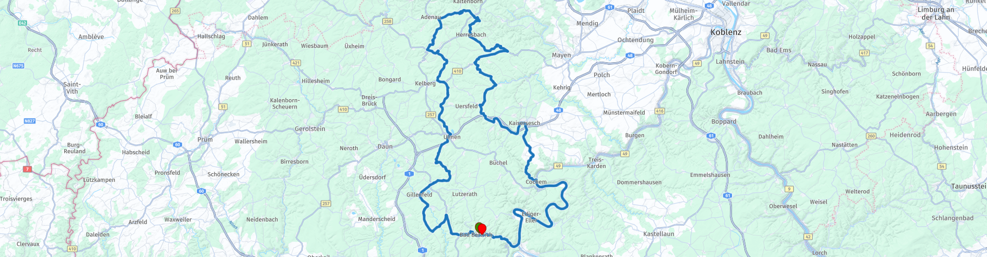
 Con una visita principale al centro informazioni / stand principale del Nurburgring.
Poi un pit stop ad Adenau lungo il Nordschleife, qui puoi stare in piedi lungo la pista.
Su questa strada passiamo le rovine di Virneburg.
E finalmente possiamo prendere una terrazza a Cochem.
 Condividi questo percorso


Animation

Verdetto


Durata
3h 4m

Modalità di viaggio
Auto o moto

Distanza
166.23 km

Paesi

 Revisione RouteXpert
 Dopo circa un'ora attraverso bellissime curve e foreste, arriviamo al Nürburgring. Il Nürburgring è un circuito di gara a Nürburg, nello stato tedesco della Renania-Palatinato. Il 27 settembre 1925 iniziò la costruzione del circuito attorno al villaggio e il castello medievale di Nürburg nell'Eifel. L'inaugurazione avvenne nel fine settimana del 18 e 19 giugno 1927. Il circuito è soprannominato "L'inferno verde". In precedenza, il percorso ha permesso ai piloti di superare i 28 km. Consisteva allora nel Nordschleife (22,8 km) e nel Südschleife (7,7 km). Il Nürburgring Nordschleife fa parte del vecchio Nürburgring. I 21 Gran Premi si sono disputati tra il 1951 e il 1976. L'ex Nürburgring, che aveva una lunghezza di soli 20,8 km, aveva ucciso cinque piloti di Formula 1 nelle competizioni del Grand Prix e causato molti altri a subire lesioni permanenti. L'enorme circuito fu costruito come un progetto di creazione di posti di lavoro negli anni '20 intorno al villaggio di Nürburg nelle montagne dell'Eifel a sud-ovest di Bonn. Conteneva ufficialmente 176 curve distribuite sui 20,8 km del Nordschleife e 7,7 km del Südschleife separato. Le curve sono conosciute come Flugplatz, Aremberg, Bergwerk, Karussel e Pflanzgarten. C'è molto da vedere allo stand principale del circuito, ci sono vecchie macchine di formula 1 e ci sono negozi che vendono ogni tipo di roba che ha a che fare con le corse o con il Nürburgring. Guidiamo e arriviamo ad Adenau, qui puoi vedere le auto e le motociclette che corrono al Nordschleife. Guidiamo un po 'con la pista e poi andiamo a sud a Herresbach. A Virneburg è possibile vedere Le rovine del castello di Virneburg, è la rovina di un castello sulla collina. Arrivato al nostro prossimo punto di sosta la città turistica Cochem, Cochem è una città sulla Mosella in Germania. Si trova nel Land Renania-Palatinato. È il Kreisstadt del Landkreis Cochem-Zell. La città è una città turistica dominata dalla chiusa di montagna.
Il castello di Cochem fu costruito nel 12 ° e 13 ° secolo e servì come protezione per la città e la Mosella.
Continuiamo il nostro percorso e guidiamo un po 'più avanti lungo la Mosella.
Ad Alf torniamo a Bad Bertrich, di nuovo al nostro Hotel.
Apprezzo questo percorso con curve a 5 stelle e abbastanza da fare durante questo percorso.
Questo percorso è stato adattato per Navigazione MRA / Garmin e TomTom.


 Collegamenti
  Utilizzo
 Vuoi scaricare questo percorso?
Puoi scaricare il percorso gratuitamente senza un account MyRoute-app. Per farlo, apri il percorso e fai clic su 'Salva con nome'. Vuoi modificare questa rotta?
Nessun problema, inizia aprendo il percorso. Segui il tutorial e crea il tuo account MyRoute-app personale. Dopo la registrazione, la tua prova inizia automaticamente.  Disclaimer
L'utilizzo di questo percorso GPS è a tue spese e rischio. Il percorso è stato accuratamente composto e controllato da un RouteXpert accreditato dall'app MyRoute per l'utilizzo su TomTom, Garmin e navigazione dell'app MyRoute.
Ciononostante potrebbero essersi verificati cambiamenti a causa di mutate circostanze, deviazioni stradali o chiusure stagionali. Si consiglia pertanto di controllare ciascun percorso prima dell'uso.
Utilizzare preferibilmente la tracklog del percorso nel sistema di navigazione. Maggiori informazioni sul l'uso dell'app MyRoute può essere trovato sul sito Web in 'Community' o 'Academy'.

Hunsrück
Informazioni su questa regione
Le ardesie di Hunsrück sono un lagerstätten della Germania occidentale, famoso in tutto il mondo per il suo tipo di fossilizzazione particolare: gli organismi, conservati piritizzati, conservano in dettaglio molte parti molli. Risalgono al Devoniano inferiore (408-400 milioni di anni fa).
Leggi di più su Wikipedia
Visualizza regione
 Statistiche
  61
61Quantità di recensioni RX (Hunsrück)
 16894
16894Quantità di visitatori (Hunsrück)
 10048
10048Quantità di download (Hunsrück)
 Indirizza le collezioni in questa regione
 Gita di 11 giorni dai Paesi Bassi
8 paesi in 11 giorni; Paesi Bassi, Germania, Austria, Italia, Svizzera, Francia, Lussemburgo e Belgio. Le raccolte di questo percorso sono costituite da 10 percorsi che ho guidato con gli amici nell'estate del 2019.
L'inizio è a Geldermalsen nei Paesi Bassi, i primi 7 giorni in auto attraverso Paesi Bassi, Germania, Austria, Italia, Svizzera, Francia e un pezzo di Lussemburgo con pernottamenti in hotel.
Gli ultimi tre giorni rimani a Barweiler (D) nell'Eifel e guidi due bellissimi tour attraverso l'Eifel, il Lussemburgo e parti delle Ardenne belghe.
Non ci sono autostrade nei percorsi, solo belle strade provinciali e di campagna, molti bei passi con splendidi panorami.
Assicurati di controllare se i pass sono aperti prima di partire.
Questi sono percorsi per conducenti esperti.
Visualizza raccolta percorsi
Percorso di raccolta tornanti nell'Eifel
Questa collezione è composta dalle strade più belle e tortuose dell'Eifel. Dimentica la Bundesstraßen, dimentica la strada lungo la Mosella, se hai guidato queste strade, puoi davvero dire di essere stato all'Eifel.
Ti aspettano ben 6 percorsi e 1.800 chilometri!
Ti aspettano ben 6 percorsi e 1.800 chilometri!
Visualizza raccolta percorsi