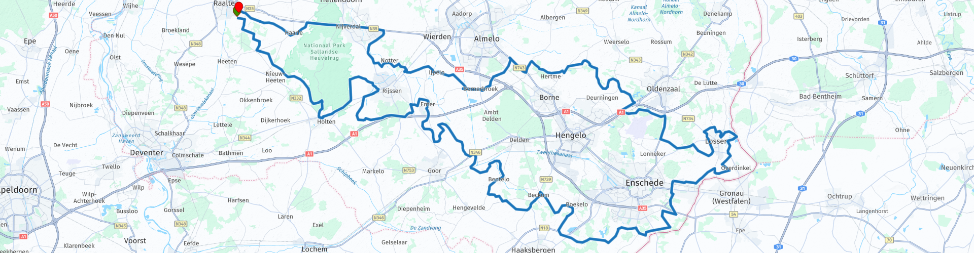
BMS Raalte rondrit 2023 via Het Hulsbeek

This route was brought to you by:
RouteXpert Hans Lamers - RouteXpert
Last edit: 28-12-2023
 Route Summary
 The route was created through the collaboration of Boshuizen Motor Service Raalte and motorcycle club MC-Freewheels from Heeten.
This route was driven on April 23, 2023.
The route is approximately 200 km long. Along the way you have plenty of opportunities to stop a number of times and visit special places.
The roads wind through the beautiful Twente area and the Sallandse Heuvelrug, the views are fantastic, so the 4-star rating is certainly appropriate.
 Share this route


Animation

Verdict


Duration
7h 16m

Mode of travel
Car or motorcycle

Distance
207.35 km

Countries


 RouteXpert Review
 Holten is a village in the Salland region and has been part of the Twente municipality of Rijssen-Holten in the Twente region since 2001. Before that, Holten was an independent municipality. Holten had 9,410 inhabitants on January 1, 2021. Holten is located on the Holterberg at the southern end of the Sallandse Heuvelrug.
The drive through the Holterberg also offers breathtaking views and winding roads surrounded by the soothing sounds of nature. A feeling that makes every motorcyclist's heart beat faster. It is also possible to visit the Canadian cemetery or the nature museum on the Holterberg.
The route then continues towards Rijssen, a city steeped in history and vibrancy. The city center with its characteristic market square and cozy streets. You can discover hidden gems with a walk through the historic center. The lively atmosphere of Rijssen contrasted perfectly with the tranquility of the natural environment.
On to Enter, a village on the Regge in the west of Twente where you can make a coffee stop at cafe Bolscher. You can enjoy the peace and quiet while enjoying a cup of coffee with a piece of traditionally baked apple pie. The village breathes history and take some time to get lost in the local stories and the warm-hearted residents. There is also a beautiful clog museum within walking distance (200 meters). During the school holidays, demonstrations are given on Wednesday and Thursday afternoons to show how the clogs were traditionally made by hand.
After this refreshing coffee stop, you can continue the route towards deeper Twente. Every bend makes new discoveries and the freedom of the winding roads gives you a good feeling. Via Bentelo, a small village steeped in charm, the route heads towards Boekelo, after which you can have lunch when you arrive in Beckum. A great opportunity for this is "The Beckum coat of arms". Highly recommended is a big bouncer or as the Germans call it, the Strammer max.
With the memory of an excellent lunch you get back on the motorcycle for the next stage of the tour.
The road to Boekelo becomes a continuation of the scenic feast, with every bend revealing new panoramas.
The route continues around Enschede, Glanerbrug, Overdinkel and Losser and reveals a beautiful landscape, with vast fields. The Hulsbeek is brought closer with every turn. The route offers a varied landscape, from winding roads to open roads with endless views. Arriving at Het Hulsbeek, the area unfolds as a hidden beauty amid the natural splendor of Twente.
You can park your motorcycle in the parking lot. You can also use the paths on foot to explore the area and perhaps take some beautiful pictures.
Back on your steel steed you can start the return journey to Raalte. The route runs through the charming village of IJpelo and takes you along small country roads.
The road to Raalte offers a variety of landscapes, from beautiful views to winding paths. Every moment on the motorcycle is a celebration of freedom and the connection with the unknown nature.
Once you arrive in Raalte you can look back on a beautiful tour through the Twente countryside.


 Links
Links  Usage
Usage Want to download this route?
You can download the route for free without MyRoute-app account. To do so, open the route and click 'save as'. Want to edit this route?
No problem, start by opening the route. Follow the tutorial and create your personal MyRoute-app account. After registration, your trial starts automatically.  Disclaimer
Use of this GPS route is at your own expense and risk. The route has been carefully composed and checked by a MyRoute-app accredited RouteXpert for use on TomTom, Garmin and MyRoute-app Navigation.
Changes may nevertheless have occurred due to changed circumstances, road diversions or seasonal closures. We therefore recommend checking each route before use.
Preferably use the route track in your navigation system. More information about the use of MyRoute-app can be found on the website under 'Community' or 'Academy'.

North Rhine-Westphalia
About this region
North Rhine-Westphalia (German: Nordrhein-Westfalen, pronounced [ˌnɔʁtʁaɪn vɛstˈfaːlən] (listen); Low Franconian: Noordrien-Wesfale; Low German: Noordrhien-Westfalen; Colognian: Noodrhing-Wäßßfaale), commonly shortened to NRW (German: [ɛnʔɛʁˈveː] (listen)), is a German state (Land) in Western Germany. With more than 17.9 million inhabitants, it is the most populous state of Germany. Covering an area of 34,084 square kilometres (13,160 sq mi), it is the fourth-largest German state by size. Apart from the city-states, it is also the most densely populated state in Germany.
North Rhine-Westphalia features 30 of the 81 German municipalities with over 100,000 inhabitants, including Cologne (over 1 million), the state capital Düsseldorf, Dortmund and Essen (all about 600,000 inhabitants) and other cities predominantly located in the Rhine-Ruhr metropolitan area, the largest urban area in Germany and the third-largest on the European continent. The location of the Rhine-Ruhr at the heart of the European Blue Banana makes it well connected to other major European cities and metropolitan areas like the Randstad, the Flemish Diamond and the Frankfurt Rhine-Main Region.
North Rhine-Westphalia was established in 1946 after World War II from the Prussian provinces of Westphalia and the northern part of Rhine Province (North Rhine), and the Free State of Lippe by the British military administration in Allied-occupied Germany and became a state of the Federal Republic of Germany in 1949. The city of Bonn served as the federal capital until the reunification of Germany in 1990 and as the seat of government until 1999.
Culturally, North Rhine-Westphalia is not a uniform area; there are significant differences, especially in traditional customs, between the Rhineland region on the one hand and the regions of Westphalia and Lippe on the other. The state has always been Germany's powerhouse with the largest economy among the German states by GDP figures.
Read more on Wikipedia
North Rhine-Westphalia features 30 of the 81 German municipalities with over 100,000 inhabitants, including Cologne (over 1 million), the state capital Düsseldorf, Dortmund and Essen (all about 600,000 inhabitants) and other cities predominantly located in the Rhine-Ruhr metropolitan area, the largest urban area in Germany and the third-largest on the European continent. The location of the Rhine-Ruhr at the heart of the European Blue Banana makes it well connected to other major European cities and metropolitan areas like the Randstad, the Flemish Diamond and the Frankfurt Rhine-Main Region.
North Rhine-Westphalia was established in 1946 after World War II from the Prussian provinces of Westphalia and the northern part of Rhine Province (North Rhine), and the Free State of Lippe by the British military administration in Allied-occupied Germany and became a state of the Federal Republic of Germany in 1949. The city of Bonn served as the federal capital until the reunification of Germany in 1990 and as the seat of government until 1999.
Culturally, North Rhine-Westphalia is not a uniform area; there are significant differences, especially in traditional customs, between the Rhineland region on the one hand and the regions of Westphalia and Lippe on the other. The state has always been Germany's powerhouse with the largest economy among the German states by GDP figures.
View region
 Statistics
  140
140Amount of RX reviews (North Rhine-Westphalia)
 79268
79268Amount of visitors (North Rhine-Westphalia)
 34156
34156Amount of downloads (North Rhine-Westphalia)
 Route Collections in this region
 The 10 most beautiful car and motorcycle routes in Limburg
Limburg, who thinks of Limburg, thinks of flan, coal mines, marl and the hill country. The coal mines have been closed for almost 40 years, the last load of coal was brought up from the Oranje-Nassau coal mine in Heerlen on 31 December and, as they say, South Limburg was transformed from Black to Green and unfortunately there is still little left. view of this period.
But not only pie, marl and coal in Limburg, but also a very beautiful province to tour by car or motorcycle and enjoy all the beauty that the province of Limburg has to offer. For this, the MyRoute app RouteXpert has put together a Top 10 of Car and Motorcycle routes for you.
All routes in this collection have been checked and made equal for TomTom, Garmin and MyRoute-app Navigation by a MyRoute-app RouteXpert.
If you think, I have a very nice route that should certainly not be missing from this collection, send it to:
email: routeexpert@myrouteapp.com
Subject: New Route for the Top 10 collection Province of Limburg composed by Hans van de Ven.
The route will then be reviewed and then added to the Top 10.
To make the Top 10 also the Top 10, 1 route will have to disappear from the Top 10, you can indicate this when submitting the new route.
Have fun with this collection and while driving one of these routes. Enjoy all the beauty that the Netherlands and in particular the province of Limburg has to offer. Click on “View route” to read the review of the chosen route.
I would like to hear your findings about the route(s).
View Route Collection
Top 5 Car and Motorcycle Routes in the Eifel
The Eifel is the eastern part of the medium plateau Eifel-Ardennes. It is located north of the Moselle and west of the Rhine. The largest part is in Germany, a small part is in Belgium, in the East Cantons. The German part of Eifel is located in the federal states of North Rhine-Westphalia and Rhineland-Palatinate. The highest point is the Hohe Acht with 747 meters.
Several chains can be distinguished in the Eifel:
The northernmost part is called the Nordeifel, which in Belgium connects to the High Fens;
To the east of this is the Ahrgebirge, this part is located north of the Ahr in the Ahrweiler district;
South of the Ahr is the Hohe Eifel (or Hocheifel), of which the Hohe Acht (747 m) is the highest point, and also the highest point in the entire Eifel region;
To the west, near the Belgian border, the hills are known as Schneifel, part of the wider Snow Eifel area with peaks reaching up to 698 metres;
South and east of the Hohe Eifel is the Volcano-Eifel, a volcanic area with many crater lakes (Maare).
The southern part of the Eifel is less high. The area is bisected by streams and rivers running southwards. These streams flow into the Moselle. The largest of these rivers is the Kyll; the hills around this river are known as the Kyllwald;
In the south, the Eifel ends in the Voreifel.
In the north of the Eifel there are some large reservoirs. The largest of these is the reservoir in the Roer that was created by the construction of the Roerdal dam.
The Nürburgring is also located in the Eifel, a well-known car circuit for Formula 1 races, among other things. Since 2004, part of the north of the Eifel has become the Eifel National Park. This National Park falls entirely within the German-Belgian nature park High Fens-Eifel. Another part of the Eifel falls within the South Eifel Nature Park.
Well-known throughout the Netherlands and Belgium by car and motorcyclists, so reason enough for the MyRoute app RouteXpert to compile a Top 5 of Car and Motorbike routes for you.
All routes in this collection have been checked and made equal for TomTom, Garmin and MyRoute-app Navigation by a MyRoute-app RouteXpert.
If you think, I have a very nice route that should certainly not be missing from this collection, send it to:
email: routeexpert@myrouteapp.com
Subject: New Route for the Top 5 collection Eifel composed by Hans van de Ven.
The route will then be reviewed and then added to the Top 5. To make the Top 5 also the Top 5, 1 route will have to disappear from the Top 5, you can indicate this when submitting the new route.
Have fun with this collection and while driving one of these routes. Enjoy all the beauty that the Eifel has to offer. Click on “View route” to read the review of the chosen route.
I would like to hear your findings about the route(s).
View Route Collection