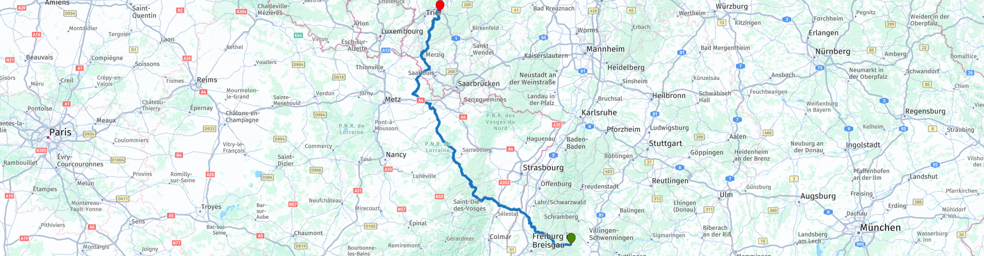
R09 Voehrenbach to Riol

This route was brought to you by:
RouteXpert Arno van Lochem - Senior RX
Last edit: 24-09-2022
 Route Summary
 In the first eight parts, if you have completed all routes, you have now completed 32 passes. In this route you 'master' the last 3. They are all located in the foothills of the Vosges and are quite fun to drive. Before you get to these passes, you first drive through the beautiful Alsace with its many vineyards. Via the German Saarland you meander further north until the route ends in Riol near the Moselle at hotel M13.
Because of the beautiful surroundings, the lovely French steering roads and all the interesting things to see along the way, this route deserves 4 stars.
 Share this route


Animation

Verdict


Duration
9h 1m

Mode of travel
Car or motorcycle

Distance
368.15 km

Countries


 RouteXpert Review
 The first part takes you through the beautiful Black Forest. You drive eastwards via beautifully winding roads, towards the border. After 75 kilometers you reach the Rhine, which forms the border between France and Germany here. With the ferry Rhinau-Kappel you will be taken to the other side. This crossing is free, there is no charge.
On the other side of the Rhine you have arrived in Alsace, a region in the far east of France. The area was added to the newly established Grand Est region in 2016. On January 1, 2021, the departments of Bas-Rhin and Haut-Rhin were administratively merged into the Collectivité Européenne d'Alsace, giving Alsace again an administrative function.
The Alsace is, among other things, known as a wine region of white wine, including Riesling and Sylvaner. Tourism is also of great importance. The Alsatian cuisine, with a strong southern German influence, consists of hearty food, adapted to the long, dark and cold winters.
The first 25 kilometers in France are very nice. First you drive through the rolling meadows, further on more and more vineyards appear. Not surprising, this region is of course known for its wines.
In the center of Andlau you have the idea of going back in time. Beautiful houses, all neatly maintained and flower boxes on the facades, a very colorful whole. The cozy market with terraces invite you for a cup of coffee and something delicious. Definitely do it.
Just behind the square you will find a museum, Les ateliers de la Seigneurie. This is a local cultural development resource that aims to help visitors explore and understand the heritage of both the Pays de Barr region and Alsace itself.
The museum is housed in one of the iconic buildings of the village, a former residence of the lords of Alsace, built between 1582 and 1583 and a characteristic example of noble Renaissance architecture.
The permanent exhibition occupies the 1st, 2nd and 3rd floors of the Seigneurie, totaling 700 m² and covers themes related to architecture, wine production and crafts.
The various aspects of the local heritage are explored through exhibits illustrating the building itself and its archaeological excavations, local half-timbered houses and castles, religious architecture, wine production and crafts.
After this idyllic village you continue on the D425, a truly beautifully landscaped road. Usually through the woods, but every now and then a view over a meadow and a single hamlet. Soon the first pass presents itself, the Col du Kreuzweg.
Col de Kreuzweg from Andlau is a climb in the Grand Est region. It is 13 kilometers long and spans 548 vertical meters with an average gradient of 4.2%. The top of the climb is at 768 meters altitude. No unobstructed view on top, trees prevent the view unfortunately.
Shortly after this pass you leave the D425 and continue on the D57. This one meanders just as pleasantly through the woods so that you soon reach the second pass, the Col de la Charbonnière.
The Col de la Charbonnière is 8.66 km long, has its highest point at 961 m and rises over a distance of 8.66 km at an average of 6.5%. On top of the col is an inn with the same name as the col. It's that you just had a coffee stop in Andlau, otherwise this would be a nice place for coffee too.
Further on the D57 you continue to drive through the woods. Little built-up area, occasionally a stray exit, but it's just nice to drive on this road, great!
Via the D1420 and the D392 you arrive at the third and last pass of this route (even the last of this tour, or number 35!), the col du Donon. The Donon is a mountain in the Vosges, in France. The mountain is formed by a block of sandstone stuck to the granite bottom. The Red Saar, Sarre rouge, and the White Saar, Sarre blanche, rise from the Donon, which later unite to form the Saar. The department in which the Donon is located is Bas-Rhin, the commune of Grandfontaine.
At the top is a neoclassical style temple, the Temple du Donon, founded by Napoleon III.
But then... the D993. From Col de Donon, where you turn right on top and enter the D993, it is 18 kilometers to enjoy. What a beautiful driving route that is! Almost no traffic, lovely curves, slightly hilly and a great environment. You almost run out of superlatives for this stretch!
The part afterwards is not bad either, but you notice that the winding roads have made way for the somewhat longer straights. The environment remains beautiful, so you will not be bored.
The north of France is also known for carp anglers. The many lakes in this area seem to house considerable tanks of carp, many Dutch fisherman will try his luck here for several days. You will pass Étang de Besville, a lake that is also popular with fishermen. Of course you can also just take a look at the water, it's quite soothing... :-)
A little further on, something less soothing, namely a reminder of the Second World War. This casemate (a space covered against enemy fire and provided with embrasures for the placement of a firearm on land or on a warship) near Francaltroff (Blockhaus C13) was part of the Secteur Fortifié de la Sarre (Maginot Line). On May 15, 1940, this casemate was fought over, in which 3 German pioneers were killed. On 20 November 1944 Francaltroff and the surrounding casemates were attacked by Combat Command A of the 4th Armored Division. At the casemate is an American M16 Halftrack.
It is known that in Normandy there is still a lot to look at what happened during that terrible period. But the northeast of France is also quite well equipped with monuments and museums about WWII, including this C13.
35 kilometers further along the route you will pass a second reminder of WWII, Ouvrage de Mottenberg. It concerns a 'less work' (petit ouvrage) of the Maginot Line. Part of the fortified sector of Boulay, the ouvrage consists of an access block and two infantry blocks and is located between the petits ouvrages Coume Annexe Sud and Kerfent, facing Germany.
The site was investigated by CORF (Commission d'Organisation des Régions Fortifiées), the design and construction bureau of the Maginot Line; Mottenberg was approved for construction in September 1931. It was completed at a cost of 13 million francs. The petit ouvrage was supposed to have a separate access block, an 81mm mortar turret and a 135mm gun turret in a second phase, but this was never implemented.
Mottenberg consists of three infantry blocks. The blocks are connected by deep underground galleries, which also provide space for barracks, utilities and ammunition storage. The galleries have been excavated at an average depth of up to 30 meters.
25 kilometers further you exchange France for Germany and you drive in the state of Saarland. That does not take very long, by the way, after 40 kilometers you are in Rhineland-Palatinate. After the last coffee stop in Merzigs, you meander further north on mostly minor roads until you finally arrive at the M13 hotel in Riol. This hotel is known from R01, which ended there as well. Reminder: Here you can plunge down a toboggan run if you wish. A beer on the terrace is of course also possible.
Have fun driving this route!


 Links
Links  Usage
Usage Want to download this route?
You can download the route for free without MyRoute-app account. To do so, open the route and click 'save as'. Want to edit this route?
No problem, start by opening the route. Follow the tutorial and create your personal MyRoute-app account. After registration, your trial starts automatically.  Disclaimer
Use of this GPS route is at your own expense and risk. The route has been carefully composed and checked by a MyRoute-app accredited RouteXpert for use on TomTom, Garmin and MyRoute-app Navigation.
Changes may nevertheless have occurred due to changed circumstances, road diversions or seasonal closures. We therefore recommend checking each route before use.
Preferably use the route track in your navigation system. More information about the use of MyRoute-app can be found on the website under 'Community' or 'Academy'.

Saarland
About this region
The Saarland (, US also , German: [ˈzaːɐ̯lant] (listen); French: Sarre [saʁ]) is a state of Germany in the west of the country. With an area of 2,570 km2 (990 sq mi) and population of 995,600 in 2015, it is the smallest German state in area apart from the city-states of Berlin, Bremen, and also Hamburg, and the smallest in population apart from Bremen. Saarbrücken is the state capital and largest city; other cities include Neunkirchen and Saarlouis. Saarland is mainly surrounded by the department of Moselle (Grand Est) in France to the west and south and the neighboring state of Rhineland-Palatinate in Germany to the north and east; it also shares a small border about 8 kilometres (5 miles) long with the canton of Remich in Luxembourg to the northwest.
Saarland was established in 1920 after World War I as the Territory of the Saar Basin, occupied and governed by France under a League of Nations mandate. The heavily industrialized region was economically valuable, due to the wealth of its coal deposits and location on the border between France and Germany. Saarland was returned to Nazi Germany in the 1935 Saar status referendum. Following World War II, the French military administration in Allied-occupied Germany organized the territory as the Saar Protectorate on 16 February 1946. After the 1955 Saar Statute referendum, it joined the Federal Republic of Germany as a state on 1 January 1957. Saarland used its own currency, the Saar franc, and postage stamps issued specially for the territory until 1959.
Read more on Wikipedia
Saarland was established in 1920 after World War I as the Territory of the Saar Basin, occupied and governed by France under a League of Nations mandate. The heavily industrialized region was economically valuable, due to the wealth of its coal deposits and location on the border between France and Germany. Saarland was returned to Nazi Germany in the 1935 Saar status referendum. Following World War II, the French military administration in Allied-occupied Germany organized the territory as the Saar Protectorate on 16 February 1946. After the 1955 Saar Statute referendum, it joined the Federal Republic of Germany as a state on 1 January 1957. Saarland used its own currency, the Saar franc, and postage stamps issued specially for the territory until 1959.
View region
 Statistics
  18
18Amount of RX reviews (Saarland)
 19787
19787Amount of visitors (Saarland)
 3172
3172Amount of downloads (Saarland)
 Route Collections in this region
 11 day trip from the Netherlands
8 countries in 11 days; The Netherlands, Germany, Austria, Italy, Switzerland, France, Luxembourg and Belgium. This route collections consists of 10 routes that I have driven with friends in the summer of 2019.
The start is in Geldermalsen Netherlands, the first 7 days you drive through the Netherlands, Germany, Austria, Italy, Switzerland, France and a piece of Luxembourg with overnight stays in hotels.
The last three days you stay in Barweiler (D) in the Eifel and you drive two beautiful tours through the Eifel, Luxembourg and parts of the Belgian Ardennes.
There is no highway in the routes, only beautiful provincial and country roads, many beautiful passes with beautiful panoramas.
Be sure to check whether the passes are open before you leave.
These are routes for experienced drivers.
View Route Collection
Alps and Dolomite Mountains 2020 out of Belgium
This route collection takes you through the Austrian and Italian Alps to the massifs of the Dolomites and back.
Your counter will add up to 3122.84 kilometers and you will pass 38, among which some top ones (Stelvio, Gavia, Gardena, Pordio, Grossglockner,…) can cross off your bucket list.
There are playful ones such as the Oberjoch that only increase the appetite, but also some pamper-consuming such as the Zillertaler Höhenstrasse. But all passes, big or small, are breathtaking and wonderful, especially those of the Dolomites.
The different routes are balanced against each other. Of course the entry and exit routes require a little more stamina due to distance and duration, but even they offer you full driving pleasure once you leave the highway. There is something foreseen on every route!
From the second and up to and including the eighth day you drive 'passes', some days more than others. Top days are days five and six when you ride 10 and 9 passes respectively, which are also not of the least, but certainly of the most beautiful...
But don't worry, days 1 and 9 are also worthwhile because of the passage through the beautiful Palatinate and Black Forest. One of the most acclaimed European motorcycle roads is also on the program in this collection; the Schwarzwaldhochstrasse or the famous '500'. But the alternative to this beautiful road is also being driven; less crowded, but no less beautiful for that.
You don't have to be a superman or woman to bring this collection to a successful conclusion. Due to the balancing, the routes are measured against each other and sufficient rest is provided between the heavier and lighter rides. In addition, shortenings are offered in various routes so that you can make the choice to fully enjoy the motorcycle fun, opt for the luxury provided in the selected hotels or visit some of the highlights marked on the routes.
For example, a cable car ride is possible, as well as a flight with the longest zipline in Europe (recommended!).
The selected hotels not only pamper your engine (garage) and digestive system, but also your body through the wellness facilities on offer.
Excellent roads, from day 1, wonderfully rolling asphalt and fantastic views in wonderful and rough nature, in combination with great hotels and possible experiences. That's what this collection offers you.
It's up to you to take it and let us know how you found it. At least if you find your speech again, because you will be speechless at times, especially in the mighty Dolomites…
Enjoy!
View Route Collection