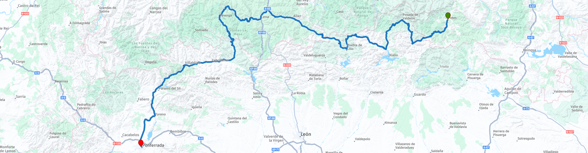
Potes to Ponferrada

Esta ruta fue hecha por:
RouteXpert Nick Carthew - (MRA Master)
Última edición: 10-04-2025
 Resumen de ruta
  Compartir esta ruta


Animation

Veredicto


Duración
8h 10m

Modo de viaje
Coche o motocicleta

Distancia
343.99 km

Países

 Revisión de RouteXpert
 Enclavado en las montañas de León se encuentra Portilla de la Reina, un pueblo de ensueño que parece sacado de una leyenda. Sus casas enclavadas en los acantilados y su aire puro hacen de este lugar un paraíso por descubrir a 1243 m de altitud. El pueblo está protegido por cuatro afloramientos rocosos: Cuervo, Cuesta, Cruz y Cincho. El río Yuso atraviesa el centro del pueblo y es la entrada desde León al Parque Nacional de los Picos de Europa. El firme es generalmente bueno y hay varias curvas cerradas que sortear.
Frente a usted se encuentran los altos picos de la Torre del Hoyo de Liordes, de 2.477 metros, y la ligeramente más baja Torre de Salinas, de 2.447 metros a la derecha, dominando el horizonte.
He sugerido una parada para tomar un café en el pueblo de montaña de Posada de Valdeón, no hay nada mejor que saborear un café al aire libre, rodeado de picos de más de 2000 metros de altitud.
Hay mirador tras mirador y tienes que decidir en cuál parar, he destacado algunos.
El Puerto de las Señales, a 1625 metros sobre el nivel del mar, es el punto más alto de esta ruta. Las Señales es uno de los puertos de montaña más altos de la Cordillera Cantábrica, en un entorno con una gran riqueza de fauna y flora, además de miradores naturales de gran belleza paisajística. Desde su cima, también se puede observar el entorno natural de la Cordillera Cantábrica.
Luego pasarás por la estación de esquí de San Isidro que tiene en su centro la frontera entre Castilla y León y el Principado de Asturias.
La ruta sigue valles fluviales, con picos de montaña y prados en una mezcla de caminos, pero todos tienen una superficie razonable.
He sugerido una parada para almorzar en el pueblo de montaña de Bárzana, hay varios lugares para elegir pero será difícil encontrar uno mejor que Casa Jamallo, que ofrece una deliciosa cocina local a precios asequibles.
Después de comer, la ruta toma la AS-228 y sigue el río Teverga hasta un túnel. Al salir del Túnel de Valdecerca, tras 498 metros, se encontrará en el Parque Natural de Las Ubiñas-La Mesa. La gran riqueza biológica del Parque Natural de Las Ubiñas-La Mesa lo convierte en uno de los pocos lugares donde aún se puede avistar al magnífico oso pardo. Se cree que solo quedan unos 400 ejemplares en libertad, pero se encuentra en plena zona de osos, así que manténgase alerta.
Una vez más, las vistas y el paisaje son espectaculares y las carreteras tienen algunas curvas buenas y rápidas y un buen pavimento, lo que hace que esta ruta sea ideal para motocicletas.
A medida que el valle se estrecha, puedes parar a cargar combustible y luego pasarás por las escarpadas Gargantas del Páramo, un desfiladero angosto con acantilados escarpados a ambos lados y también un corto túnel de roca, otra gran ruta para motocicletas.
Hay miradores a lo largo de este tramo de la ruta y, como la carretera no está muy transitada, es fácil parar a tomar fotos. El Mirador de Ubiña ofrece una magnífica vista de Peña Ubiña, uno de los picos más altos de 2417 metros.
La ruta discurre por la Puente de las Palomas, que cruza un profundo barranco excavado por el río Sil. La ruta seguirá el Sil durante los próximos 72 kilómetros hasta la meta en el Hotel Ponferrada Plaza.
Disfrutar


 Enlaces
  Uso
Uso ¿Quiere descargar esta ruta?
Puede descargar la ruta gratis sin la cuenta de MyRoute-app. Para hacerlo, abra la ruta y haga clic en 'guardar como'. ¿Quiere editar esta ruta?
No hay problema, comience abriendo la ruta. Siga el tutorial y cree su cuenta personal de MyRoute-app. Después de registrarse, su prueba comienza automáticamente.  Descargo de responsabilidad
El uso de esta ruta GPS es por su cuenta y riesgo. La ruta ha sido cuidadosamente compuesta y verificada por un RouteXpert acreditado por MyRoute-app para su uso en TomTom, Garmin y MyRoute-app Navigation.
No obstante, es posible que se hayan producido cambios debido a circunstancias cambiantes, desvíos de carreteras o cierres estacionales. Por lo tanto, recomendamos comprobar cada ruta antes de utilizarla.
Utilice preferentemente el track de ruta en su sistema de navegación. Más información sobre el el uso de la aplicación MyRoute se puede encontrar en el sitio web en 'Comunidad' o 'Academia'.

Asturias
Acerca de esta región
El Principado de Asturias (en asturiano, Principáu d'Asturies; en eonaviego, Principao d'Asturias) es una comunidad autónoma uniprovincial de España, con una población de 1 028 244 habitantes (INE, 2018).[6] Bañada al norte por las aguas del mar Cantábrico, limita al oeste con la provincia de Lugo (Galicia), al sur con la provincia de León (Castilla y León) y al este con Cantabria. Recibe el nombre de Principado por razones históricas, al ostentar el heredero de la corona de Castilla y, por extensión, de la corona de España el título nobiliario de príncipe de Asturias, establecido por Juan I de Castilla en el año 1388. Oviedo es, según el Estatuto de Autonomía, sede de las instituciones del Principado de Asturias; la ciudad más poblada de la comunidad es Gijón.
El actual espacio territorial asturiano coincide básicamente con el antiguo territorio de las Asturias de Oviedo, contiguas a las Asturias de Santillana. Con la división territorial de Javier de Burgos en 1833, la región de las Asturias de Oviedo se convirtió en la provincia de Oviedo, recibiendo una porción del territorio de las Asturias de Santillana —los concejos de Peñamellera Alta, Peñamellera Baja y Ribadedeva—, mientras el resto de las mismas se integró en la provincia de Santander, posterior comunidad autónoma de Cantabria.
El Principado de Asturias según su Estatuto de Autonomía está considerado como una comunidad histórica en su artículo 1. Posee una asamblea legislativa llamada Junta General del Principado, en recuerdo de una antigua institución medieval de representación de los concejos ante la Corona.[7] Coincide su territorio en parte además, con la zona nuclear del antiguo reino de Asturias del año 718 y posee dos idiomas propios: el asturiano o bable, del tronco lingüístico asturleonés, que aun no siendo considerada lengua oficial, tiene un estatus jurídico parecido al de la oficialidad y el eonaviego o gallego-asturiano, del tronco lingüístico galaicoportugués, hablado en los concejos del extremo occidental y que goza de un estatus similar.
Leer más en Wikipedia
El actual espacio territorial asturiano coincide básicamente con el antiguo territorio de las Asturias de Oviedo, contiguas a las Asturias de Santillana. Con la división territorial de Javier de Burgos en 1833, la región de las Asturias de Oviedo se convirtió en la provincia de Oviedo, recibiendo una porción del territorio de las Asturias de Santillana —los concejos de Peñamellera Alta, Peñamellera Baja y Ribadedeva—, mientras el resto de las mismas se integró en la provincia de Santander, posterior comunidad autónoma de Cantabria.
El Principado de Asturias según su Estatuto de Autonomía está considerado como una comunidad histórica en su artículo 1. Posee una asamblea legislativa llamada Junta General del Principado, en recuerdo de una antigua institución medieval de representación de los concejos ante la Corona.[7] Coincide su territorio en parte además, con la zona nuclear del antiguo reino de Asturias del año 718 y posee dos idiomas propios: el asturiano o bable, del tronco lingüístico asturleonés, que aun no siendo considerada lengua oficial, tiene un estatus jurídico parecido al de la oficialidad y el eonaviego o gallego-asturiano, del tronco lingüístico galaicoportugués, hablado en los concejos del extremo occidental y que goza de un estatus similar.
Ver región
 Estadísticas
  16
16Cantidad de revisiones de RX (Asturias)
 23447
23447Cantidad de visitantes (Asturias)
 1345
1345Cantidad de descargas (Asturias)
 Ruta de colecciones en esta región
 Tres recorridos por los Picos de Europa y sus alrededores en el norte de España
Los Picos de Europa es una zona montañosa del norte de España, junto al País Vasco. En el medio está el pueblo de Posada de Valdeón, al que no se puede llegar en moto desde el norte: hay que circular por los Picos por Potes o Sames. Pasamos la noche en la Posada de Valdeón en el Hostal Casa Abascal. Un gran hotel con opción de desayuno. Se puede comer en un restaurante del pueblo que suele elegir entre dos menús.
Hay todo tipo de reservas naturales alrededor de los Picos. Estas tres rutas te llevan a través de algunas de ellas. Hay quebradas para ver, miradores, embalses y se puede caminar más que bien. Si le gusta caminar, traiga sus zapatos para caminar.
Pero venimos a montar y va genial. Excelentes carreteras con algún que otro trozo de tierra sin pavimentar para no tener que desviarse mucho hacia otra atracción. Se puede comer comida deliciosa y la gente es muy agradable y hospitalaria. Y debido a que la ruta a Lourdes pasa por encima de los Picos, también hay lugares de peregrinaje e iglesias y monasterios muy bonitos. Lo más hermoso de esta área es la naturaleza: increíblemente hermosa con animales salvajes, montañas escarpadas y ríos salvajes.
En total, puedes pasar al menos 4 días aquí si te tomas un día de descanso o sales a caminar.
Ver colección de rutas
De Santander a Roscoff vía Picos de Europa Pirineos Costa oeste de Francia
Un recorrido con 9 rutas que se conectan entre sí, comenzando desde el puerto de Santander hasta Potes por carreteras con muchas curvas. La siguiente ruta es un recorrido circular inolvidable desde Potes hasta los siempre populares Picos de Europa. Después, el recorrido se dirige al sur y al este, pasando por embalses y retomando el caudaloso río Ebro, para seguirlo hasta Miranda de Ebro. La Ruta 4 continúa hacia el este, en dirección a los Pirineos, con más curvas, hasta llegar a Sos del Rey Católico, un fantástico pueblo fortificado en la cima de una colina. La siguiente ruta cruza los Pirineos con la posibilidad de subir en teleférico a una montaña para almorzar. La Ruta 6 es el primer día en Francia y ofrece un agradable paseo por campos de girasoles y maíz, pinares y el Parque Natural Regional de las Landas de Gascuña. Después, cruza el imponente estuario de la Gironda en ferry y llega a la meta en la popular ciudad costera de La Rochelle. Nos alojamos dos noches en La Rochelle para disfrutar de las delicias de esta encantadora ciudad. La Ruta 7 bordea la costa en dirección norte y cruza el caudaloso río Loira para pasar la noche en Saint Nazaire. La Ruta 8 comienza con una visita a los refugios para submarinos en Saint Nazaire, para luego atravesar los campos de producción de sal de Guérande y llegar a Concarneau, otra histórica ciudad amurallada de visita obligada. La ruta final lleva a Pointe du Raz y luego a Locronan, un pueblo medieval catalogado como uno de los pueblos más bellos de Francia. Después, cruza el puente de Térénez, el primer puente atirantado curvo del mundo. Después, se adentra y atraviesa el Parque Natural Regional de Armórica para pasar la noche en un hotel con desayuno en Morlaix, listo para un breve viaje por la mañana para tomar el ferry en Roscoff.
Ver colección de rutas