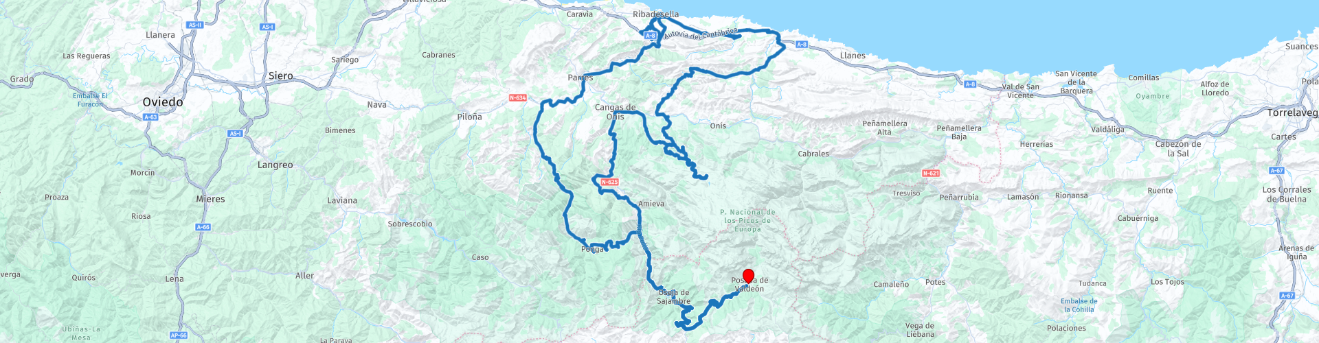
Roundtrip Posada de Valdeon Covadonga Ribadesella Ponga

Diese Route wurde erstellt von:
RouteXpert Evert Kuiken
Letzte Änderung: 22-12-2020
 Routenzusammenfassung
  Diese Route teilen


Animation

Urteil


Dauer
6h 41m

Reisemodus
Auto oder Motorrad

Entfernung
276.03 km

Länder

 RouteXpert-Überprüfung
 Im Restaurant Orandi (RP 6) können Sie Kaffee trinken. Von hier aus beginnt ein touristisches Stück. Fast alles hier ist beschäftigt und touristisch. Dieser Ort war noch ruhig, als wir dort waren, aber der riesige Parkplatz deutete darauf hin, dass es normalerweise geschäftiger ist. Sie können auch nach Covadonga fahren oder auf dem Berg eine Tasse Kaffee trinken, aber dann sind Sie erheblich teurer. Sie fahren jetzt den Berg hinauf zum und entlang des Lago Enol, danach können Sie auf dem Berg parken. Dort gibt es viel zu tun. Lago Enol macht Spaß. Der Aussichtspunkt Mirador de La Picota ist sehr schön (obwohl wir nur Nebel gesehen haben ...) und Sie sollten auch Mirador del Principe de Asturias sehen. Sie können im Restaurante El Casín (einfach) oder in der Bar Maria Rosa (luxuriöser) essen. Es gibt auch ein Besucherzentrum: Centro de Visitantes Pedro Pidal. Wenn Sie fertig sind, fahren Sie die schmale kurvenreiche Straße zurück nach Covadonga. Achten Sie auf alle Touristenbusse! Wenn Sie die schöne Kirche fotografieren möchten, halten Sie bei RP 8. Dort haben Sie einen schönen Blick auf die Basilika. In Covadonga (RP 9) gibt es viele Terrassen, Pilger, eine Basilika, eine Höhle und vieles mehr. Nehmen Sie sich Zeit, wenn Sie sich unter den Touristen wohl fühlen.
Dann steigen Sie langsam auf Meereshöhe ab. Wenn Sie noch nichts gegessen haben, können Sie in der Posada de Llanes (RP 11) zu Mittag essen. Sie kommen dann zu einem kleinen Kloster: Monasterio San Antolín de Bedón (RP 12). Dann fahren Sie am Meer entlang und entlang der Strecke. Ein großartiger Ort, um sich abzukühlen oder etwas zu essen (RP 13). Dann fahren Sie nach Ribadesella. Hier können Sie wählen. Ribadesella ist ein großartiger Ort, um anzuhalten und etwas zu essen oder zu trinken. Sie können auch zuerst in die Höhle gehen, durch die Sie fahren können.
Die Höhle Cuevona de Cuevas (RP 19) ist ein ganz besonderes Erlebnis. Eine lange Fahrt durch einen Felsen im Dunkeln. Sie können auch hindurchgehen, aber achten Sie auf die Autos und Motorräder. Nach der Höhle geht es über den Fluss Sella zurück nach Ribadesella. Schauen Sie sich den Blick über den Fluss Sella an der Brücke an (RP 20).
In Ribadesella (RP 21) gibt es viel zu tun. Ein Fischmarkt (Rula), Apfelweincafés (zum Beispiel die Astrurian Sidreria El Campanu), der Turm Torre de l'Atalaya, eine Kirche am Meer (Ermita de la Virgen de Guía).
Wenn Sie es satt haben, können Sie die Hauptstraße (N-632, wird N-634) zurück in den Ponga Park nehmen. Wenn Sie eine kleine Straße bevorzugen, wählen Sie die AS-341 oder die noch kleinere AS-342. Beide beginnen an der Westseite des Flusses Sella. Wenn Sie eine wirklich schöne Straße wollen, fahren Sie von Ribadesella weiter westlich weiter und nehmen Sie die AS-260. In jedem Fall kommen Sie in Arriondas an. Sie können dort etwas trinken gehen, obwohl es keine sehr schöne Stadt ist. Wenn Sie anhalten, halten Sie mitten in der Stadt auf einem kleinen versteckten Platz (Plaza de Peruyal). Sehen Sie die drei markierten Restaurants.
Nach Arriondas fahren Sie auf einer rhythmisch kurvenreichen Straße einen langen Weg entlang des Flusses Sella. In Las Tercias geht es zurück in die Berge entlang des Rio Tendi. Genießen Sie die Aussicht auf Fontecha (Collado Moandi), bevor Sie den Ponga Park (RP 25) wieder betreten. Wenn nötig, gehen Sie etwas weiter den Berg hinauf. In Sellaño (RP 26) können Sie die Route verkürzen, indem Sie links abbiegen und dem Fluss Ponga nach Santillan folgen. Eine sehr schöne Straße durch Schluchten und entlang der Bergmauern. Fahren Sie weiter und folgen Sie auch dem Fluss Ponga, dann aber auf einer anderen schönen Straße. Vielleicht zuerst etwas in der Bar El Puente trinken?
In San Juan de Beleño können Sie das Besucherzentrum des Ponga-Parks (RP 27) besuchen. Es ist nicht viel und befindet sich in einem hässlichen Betongebäude. Die Stadt ist das Zentrum des Parks.
Bei RP 28 können Sie immer noch zu einem schönen Aussichtspunkt über die Berge gehen: Mirador de Les Bedules. Die Straße dort ist eng und betoniert. Also sei vorsichtig. Am Ende ist ein Parkplatz.
Diese Route bekommt 5 ***** Sterne von mir. Die Straßen sind großartig, die Umgebung ist fantastisch und es gibt viel zu sehen. Sie müssen weiterfahren, um die Route zu beenden. Es lohnt sich!


 Links
Links  Nutzung
 Möchten Sie diese Route herunterladen?
Sie können die Route ohne MyRoute-App-Konto kostenlos herunterladen. Öffnen Sie dazu die Route und klicken Sie auf 'Speichern unter'. Möchten Sie diese Route bearbeiten?
Kein Problem, starten Sie mit dem Öffnen der Route. Folgen Sie dem Tutorial und erstellen Sie Ihr persönliches MyRoute-App-Konto. Nach der Registrierung startet Ihre Testversion automatisch.  Haftungsausschluss
Die Nutzung dieser GPS-Route erfolgt auf eigene Kosten und Gefahr. Die Route wurde sorgfältig von einem MyRoute-App akkreditierten RouteXpert für die Verwendung mit TomTom, Garmin und MyRoute-App Navigation zusammengestellt und geprüft.
Durch geänderte Umstände, Straßenumleitungen oder saisonale Sperren können sich dennoch Änderungen ergeben haben. Wir empfehlen daher, jede Route vor der Nutzung zu überprüfen.
Verwenden Sie vorzugsweise den Routentrack in Ihrem Navigationssystem. Mehr Informationen zu den Die Nutzung der MyRoute-App finden Sie auf der Website unter 'Community' oder 'Academy'.

Asturien
Über diese Region
Asturien (spanisch Asturias; offiziell spanisch Principado de Asturias, asturisch Asturies, offiziell asturisch Principáu d’Asturies; deutsch Fürstentum Asturien) ist eine Autonome Gemeinschaft im Nordwesten Spaniens. Das Territorium der Autonomen Gemeinschaft ist identisch mit dem der Provinz Asturien (früher Provinz Oviedo). Die Hauptstadt ist Oviedo mit 219.686 Einwohnern (Stand: 1. Januar 2019).
Lesen Sie mehr auf Wikipedia
Region anzeigen
 Statistik
  16
16Anzahl der RX-Bewertungen (Asturien)
 23446
23446Anzahl der Besucher (Asturien)
 1345
1345Anzahl der Downloads (Asturien)
 Routensammlungen in dieser Region
 Drei Touren in und um Picos de Europa Nordspanien
Die Picos de Europa sind eine Bergregion im Norden Spaniens, neben dem Baskenland. In der Mitte liegt der Ort Posada de Valdeon, der von Norden mit dem Motorrad nicht zu erreichen ist: Man muss die Picos über Potes oder Sames umfahren. Wir übernachteten in Posada de Valdeon im Hostal Casa Abascal. Ein tolles Hotel mit Frühstücksmöglichkeit. Sie können in einem Restaurant im Dorf essen, wobei Sie normalerweise zwischen zwei Menüs wählen können.
Rund um die Picos gibt es allerlei Naturschutzgebiete. Diese drei Routen führen Sie durch einige von ihnen. Es gibt Schluchten zu sehen, Aussichtspunkte, Stauseen und man kann mehr als gut wandern. Wenn Sie gerne wandern, bringen Sie Ihre Wanderschuhe mit.
Aber wir kommen, um zu reiten und es läuft großartig. Hervorragende Straßen mit gelegentlichem unbefestigten Stück, um nicht weit für eine andere Attraktion umfahren zu müssen. Man kann lecker essen und die Leute sind sehr nett und gastfreundlich. Und weil die Route nach Lourdes oberhalb der Picos führt, gibt es auch Wallfahrtsorte und sehr schöne Kirchen und Klöster. Das Schönste in dieser Gegend ist die Natur: atemberaubend schön mit wilden Tieren, schroffen Bergen und wilden Flüssen.
Alles in allem können Sie hier mindestens 4 Tage verbringen, wenn Sie einen Ruhetag einlegen oder spazieren gehen.
Routensammlung anzeigen
Santander nach Roscoff über die Picos de Europa, Pyrenäen, Westküste Frankreichs
Eine Tour mit neun miteinander verbundenen Routen. Sie beginnt am Fährhafen Santander und führt über viele kurvenreiche Straßen nach Potes. Die nächste Route ist eine unvergessliche Rundfahrt von Potes zu den beliebten Picos de Europa. Anschließend führt die Tour Richtung Süden und Osten, vorbei an Stauseen, zum mächtigen Fluss Ebro und folgt ihm nach Miranda de Ebro. Route 4 führt weiter ostwärts in Richtung Pyrenäen auf weiteren kurvenreichen Straßen zum Ziel Sos del Rey Catolico, einem fantastischen befestigten Bergdorf. Die nächste Route führt Sie über die Pyrenäen mit der Möglichkeit einer Seilbahnfahrt auf einen Berg zum Mittagessen. Route 6 ist der erste Tag in Frankreich und eine angenehme Fahrt vorbei an Sonnenblumen- und Maisfeldern, Kiefernwäldern und durch den regionalen Naturpark Landes de Gascogne. Anschließend überqueren Sie die mächtige Gironde-Mündung mit der Fähre und fahren zum Ziel in der beliebten Küstenstadt La Rochelle. Wir blieben zwei Nächte in La Rochelle, um die Reize dieser reizenden Stadt zu erkunden. Route 7 verläuft entlang der Küste nach Norden und überquert dann die mächtige Loire für eine Nacht in Saint-Nazaire. Route 8 beginnt mit einem Besuch der U-Boot-Bunker in Saint-Nazaire, führt dann durch die Salzproduktions-„Felder“ von Guérande und weiter nach Concarneau, einer weiteren historischen Stadt mit Stadtmauer, die man unbedingt besichtigen sollte. Die letzte Route bringt Sie nach Pointe du Raz und dann nach Locronan, einem mittelalterlichen Dorf, das zu den schönsten Dörfern Frankreichs zählt. Anschließend geht es über die Térénez-Brücke, die erste gebogene Schrägseilbrücke der Welt. Anschließend betreten und durchqueren Sie den regionalen Naturpark Armorique und verbringen die Nacht in einem B&B-Hotel in Morlaix, wo Sie am nächsten Morgen eine kurze Fahrt zur Fähre nach Roscoff unternehmen können.
Routensammlung anzeigen