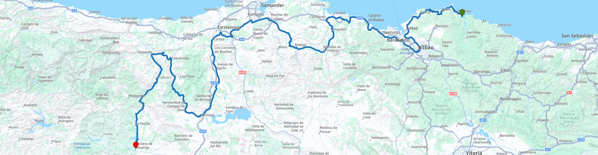
Part 2 Mundaka to Cervera de Pisuerga

Questo percorso è stato creato da:
RouteXpert Peter Moerman - RouteXpert
Ultima modifica: 24-07-2023
 Riepilogo percorso
 La parte 2 copre la costa e l'entroterra tra Mundaka e Cervera de Pisuerga, in gran parte attraverso Cantrabia.
È un percorso molto lungo, quindi parti in orario.
Valuto questo percorso attraverso i Paesi Baschi con 5 stelle a causa delle belle strade. bei panorami e molti luoghi d'interesse.
 Condividi questo percorso


Animation

Verdetto


Durata
9h 53m

Modalità di viaggio
Auto o moto

Distanza
387.39 km

Paesi

 Revisione RouteXpert
 Dopo circa 12 chilometri si può svoltare al parcheggio di Gaztelugatxe Zubia, una penisola con sopra un castello, raggiungibile solo a piedi.
San Juan de Gaztelugatxe e Gaztelugatxe Zubia sono due luoghi mozzafiato incastonati nella costa montuosa di Bizkaia, nel nord della Spagna. L'antico sentiero di pietra che collega i due è un punto culminante della regione, guadagnando popolarità grazie alla serie HBO "Game of Thrones". San Juan de Gaztelugatxe è un isolotto collegato alla terraferma da uno stretto ponte a più livelli. Una volta raggiunta la cima dell'isolotto, sarai ricompensato con viste mozzafiato sulla costa, scogliere frastagliate e le montagne dei Paesi Baschi in lontananza. Gaztelugatxe Zubia si trova nelle vicinanze e offre una delle esperienze escursionistiche più belle della zona. Puoi raggiungere la cima di Gaztelugatxe e goderti la vista idilliaca del Golfo di Biscaglia e della costa di Uribe. Entrambi i punti sono un must per chiunque cerchi grandi opportunità fotografiche e bellissime passeggiate nella natura.
Il percorso prosegue lungo la bellissima strada costiera verso Bilbao. A Portugalete hai una vista sullo speciale ponte sospeso Puente Colgante. Il Puente Colgante è un ponte sospeso che collega i villaggi di pescatori di Getxo e Portugalete. Questo ponte sospeso di Vizacaya sul fiume Ría del Nervión si trova a dieci chilometri dal centro di Bilbao e una passeggiata attraverso il ponte sospeso permette di visitare entrambi i villaggi. Soprattutto per i turisti c'è un belvedere e una passerella in cima ai pilastri, che possono essere raggiunti tramite un ascensore nei pilastri.
Bilbao è la capitale della provincia di Biscaglia e ha molto da offrire. Il più sorprendente è il Museo Guggenheim. L'edificio stesso, ma anche le collezioni meritano sicuramente una visita. Ci sono molti posti dove bere qualcosa nelle vicinanze del museo.
Più avanti lungo la costa si trova Castro Urdiales. Questa è una piacevole cittadina costiera non molto a ovest di Bilbao. A parte la bella e prominente Iglesia de Santa Maria in cima alla collina, è principalmente una rinomata località balneare. Vicino al porto si trova anche il castello "Castillo de Santa Ana" con il faro in cima. Dal castello si ha una bellissima vista sul mare, sul porto e sul centro della città di Castro Urdiales.
A Colindra, alla foce del Rio de Rada, il percorso si inoltra per un po' nell'entroterra su una bella strada tortuosa attraverso le colline prima di tornare sulla costa verso la città di Santander. A causa dell'influenza del mare, Santander ha un clima marittimo mite sia in inverno che in estate; da un lato, Santander ha le spiagge popolari in estate, ma negli altri giorni può esserci una fresca brezza marina accompagnata da rovesci che indugiano sulla regione, mentre le nuvole indugiano attraverso il massiccio montuoso dei Picos de Europa e la Cordillera Cantabria. Il tempo in Cantabria può quindi cambiare notevolmente e per molti surfisti le spiagge di Santander con onde alte sono un punto culminante.
Dopo Santander il percorso torna nell'entroterra e si vedono le montagne serie. Attraverso una serie di splendidi passi di montagna si raggiunge Puerto de Piedrasluengas. Questo passo di montagna è anche popolare tra i ciclisti e offre un bellissimo punto panoramico in cima.
Il punto di arrivo di questo lungo percorso è l'affascinante villaggio di montagna di Cervera de Pisuerga,


 Collegamenti
  Utilizzo
 Vuoi scaricare questo percorso?
Puoi scaricare il percorso gratuitamente senza un account MyRoute-app. Per farlo, apri il percorso e fai clic su 'Salva con nome'. Vuoi modificare questa rotta?
Nessun problema, inizia aprendo il percorso. Segui il tutorial e crea il tuo account MyRoute-app personale. Dopo la registrazione, la tua prova inizia automaticamente.  Disclaimer
L'utilizzo di questo percorso GPS è a tue spese e rischio. Il percorso è stato accuratamente composto e controllato da un RouteXpert accreditato dall'app MyRoute per l'utilizzo su TomTom, Garmin e navigazione dell'app MyRoute.
Ciononostante potrebbero essersi verificati cambiamenti a causa di mutate circostanze, deviazioni stradali o chiusure stagionali. Si consiglia pertanto di controllare ciascun percorso prima dell'uso.
Utilizzare preferibilmente la tracklog del percorso nel sistema di navigazione. Maggiori informazioni sul l'uso dell'app MyRoute può essere trovato sul sito Web in 'Community' o 'Academy'.

Cantabrie
Informazioni su questa regione
La Cantabria è una comunità autonoma della Spagna, coincidente con l'omonima provincia.
Confina a est con i Paesi Baschi (provincia di Biscaglia), a sud con la Castiglia e León (province di León, Palencia, e Burgos), a ovest con le Asturie, e a nord con il mar Cantabrico. Il suo capoluogo è Santander.
La Cantabria appartiene geograficamente alla cornice Cantabrica, il nome dato alla frangia di terra situata tra il mar Cantabrico e la Cordigliera Cantabrica nel nord della penisola iberica.
Possiede un clima oceanico umido e con temperature moderate, fortemente influenzato dai venti dell'oceano Atlantico che si scontrano contro le montagne della cordigliera cantabrica. Le precipitazioni medie si aggirano sui 1 200 mm l'anno. La vegetazione è per questo florida e la regione si presenta al visitatore con un colore verde acceso per molti mesi all'anno.
La Cantabria è la regione più ricca del mondo di siti archeologici del Paleolitico Superiore. I primi segni di presenza umana risalgono al Paleolitico Inferiore, sebbene di questo periodo non resti molto nella regione. Spiccano in questo contesto i graffiti preistorici della grotta di Altamira, datati tra il 16 000 e il 9 000 a.C. e dichiarati Patrimonio dell'umanità dall'UNESCO. La Cantabria condivide inoltre il Parco nazionale dei Picos de Europa con le Asturie e la Provincia di León.
La moderna provincia della Cantabria si costituì il 28 luglio 1778. La Ley Orgánica del Estatuto de Autonomía de Cantabria venne approvata il 30 dicembre 1981, dotando così la comunità autonoma di organismi e istituzioni di autogoverno.
Diversi autori hanno studiato l'etimologia del nome della Cantabria. Pur non essendo sicura la sua provenienza, l'opinione più condivisa dagli esperti è che deriva dalla radice cant-, di origine celta o ligure e che significa “roccia” o “pietra”, e il sufisso -abr, usato frequentemente nelle regioni celtiche. Di tutto questo si pensa che cántabro significa “paese che abita nelle montagne”. È una delle regioni spagnole con la toponimia più antica, il termine “cántabro” appare per prima volta nelle fonti romane del secolo II a.C. dall'autore Catone il Vecchio.
Leggi di più su Wikipedia
Confina a est con i Paesi Baschi (provincia di Biscaglia), a sud con la Castiglia e León (province di León, Palencia, e Burgos), a ovest con le Asturie, e a nord con il mar Cantabrico. Il suo capoluogo è Santander.
La Cantabria appartiene geograficamente alla cornice Cantabrica, il nome dato alla frangia di terra situata tra il mar Cantabrico e la Cordigliera Cantabrica nel nord della penisola iberica.
Possiede un clima oceanico umido e con temperature moderate, fortemente influenzato dai venti dell'oceano Atlantico che si scontrano contro le montagne della cordigliera cantabrica. Le precipitazioni medie si aggirano sui 1 200 mm l'anno. La vegetazione è per questo florida e la regione si presenta al visitatore con un colore verde acceso per molti mesi all'anno.
La Cantabria è la regione più ricca del mondo di siti archeologici del Paleolitico Superiore. I primi segni di presenza umana risalgono al Paleolitico Inferiore, sebbene di questo periodo non resti molto nella regione. Spiccano in questo contesto i graffiti preistorici della grotta di Altamira, datati tra il 16 000 e il 9 000 a.C. e dichiarati Patrimonio dell'umanità dall'UNESCO. La Cantabria condivide inoltre il Parco nazionale dei Picos de Europa con le Asturie e la Provincia di León.
La moderna provincia della Cantabria si costituì il 28 luglio 1778. La Ley Orgánica del Estatuto de Autonomía de Cantabria venne approvata il 30 dicembre 1981, dotando così la comunità autonoma di organismi e istituzioni di autogoverno.
Diversi autori hanno studiato l'etimologia del nome della Cantabria. Pur non essendo sicura la sua provenienza, l'opinione più condivisa dagli esperti è che deriva dalla radice cant-, di origine celta o ligure e che significa “roccia” o “pietra”, e il sufisso -abr, usato frequentemente nelle regioni celtiche. Di tutto questo si pensa che cántabro significa “paese che abita nelle montagne”. È una delle regioni spagnole con la toponimia più antica, il termine “cántabro” appare per prima volta nelle fonti romane del secolo II a.C. dall'autore Catone il Vecchio.
Visualizza regione
 Statistiche
  21
21Quantità di recensioni RX (Cantabrie)
 16797
16797Quantità di visitatori (Cantabrie)
 2496
2496Quantità di download (Cantabrie)
 Indirizza le collezioni in questa regione
 Tre tour nei Picos de Europa e nei dintorni della Spagna settentrionale
I Picos de Europa sono una zona montuosa nel nord della Spagna, vicino ai Paesi Baschi. Nel mezzo c'è il villaggio di Posada de Valdeon, che non può essere raggiunto in moto da nord: devi guidare intorno ai Picos via Potes o Sames. Abbiamo pernottato a Posada de Valdeon nell'Hostal Casa Abascal. Un ottimo hotel con opzione per la colazione. Si può mangiare in un ristorante del paese con solitamente una scelta tra due menù.
Ci sono tutti i tipi di riserve naturali intorno ai Picos. Questi tre percorsi ti portano attraverso alcuni di essi. Ci sono gole da vedere, punti panoramici, bacini idrici e puoi camminare più che bene. Se ti piace camminare, porta le tue scarpe da passeggio.
Ma veniamo a cavalcare e sta andando alla grande. Strade eccellenti con occasionali tratti di sterrato per non dover deviare lontano per un'altra attrazione. Puoi mangiare cibo delizioso e le persone sono molto gentili e ospitali. E poiché la strada per Lourdes va al di sopra dei Picos, ci sono anche luoghi di pellegrinaggio e chiese e monasteri molto belli. La cosa più bella di questa zona è la natura: di una bellezza mozzafiato con animali selvatici, aspre montagne e fiumi selvaggi.
Tutto sommato, puoi passare almeno 4 giorni qui se ti prendi un giorno di riposo o fai una passeggiata.
Visualizza raccolta percorsi
Dieci giorni Roadtrip dalla Spagna al Portogallo
Questa raccolta di percorsi descrive un viaggio su strada di 10 giorni nel nord della Spagna e del Portogallo, un vero paradiso per il motociclismo.
Guidi su bellissime creste montuose e attraverso splendide valli. Lungo la strada attraverserai bellissimi villaggi e innumerevoli riserve naturali, grandi passi con innumerevoli curve, tunnel tagliati fuori dalle montagne e bacini azzurri. Le strade sono da buone a buone, a volte non asfaltate.
Cosa vedrai lungo la strada;
Pirenei spagnoli
Parc Naturel del Cadi-Moixero
Serra del Cadí
Serra de Moixeró
Pedraforca
Serra del Monsec
Collada de Clarà
Parque Nacional de Ordesa e Monte Perdido
Parco Naturale Collados del Asón.
Parque natural Saja-Besaya
Parque natural de Fuentes Carrionas y Fuente Cobre
Parque natural de la Montana de Riano y Mampodre
Picos de Europa
El Parque regional Montaña de Riaño y Mampodre
El Parque natural de Redes
La Sierra de la Culebra
Parque natural Montesinho
Lungo i percorsi ci sono più che sufficienti posti carini dove fermarsi per un breve o più lungo periodo, questi sono descritti nella recensione e con waypoint e POI inclusi nei percorsi.
Divertiti a leggere e programmare la tua prossima vacanza in moto.
Se hai percorso questi percorsi, vorrei sentire il tuo feedback.
Visualizza raccolta percorsi