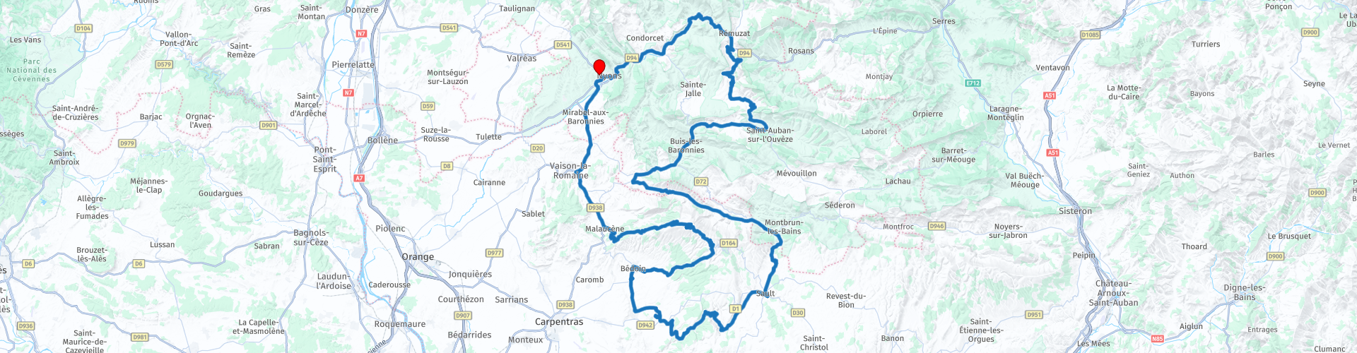
Roundtrip Nyons to Nyons passing the Nesque gorges and Mont Ventoux

Questo percorso è stato creato da:
RouteXpert Catherine De Groote RouteXpert
Ultima modifica: 09-11-2021
 Riepilogo percorso
 Il Mont Ventoux è l'unica montagna di questa altezza (1912 m) nella regione ed è quindi chiamato anche il Gigante della Provenza. Le Gorges de la Nesque sono una profonda gola all'ombra del Mont Ventoux. Tra Villes-sur-Auzon e Monieux, una bella strada attraversa la gola con una vista spettacolare sul fiume che si snoda nella campagna quattrocento metri più in basso.
Le strade sono in ottime condizioni. Il Mont Ventoux e le Gorges de la Nesque sono due punti salienti di questa corsa. Si sale sul Mont Ventoux da Malaucène e lo si scende a Bedoin. Attraverserai anche il Parco Naturale Regionale delle Baronnies Provençales con i suoi prati, campi di lavanda e uliveti. Questa corsa percorre molte strade verdi Michelin e quindi ottiene 5 stelle.
 Condividi questo percorso


Animation

Verdetto


Durata
8h 45m

Modalità di viaggio
Auto o moto

Distanza
227.59 km

Paesi

 Revisione RouteXpert
 Passerai davanti a grandi aziende vinicole, uliveti e campi di lavanda fino a Malaucène, ai piedi del famoso Mont Ventoux. Il villaggio è uno dei tre punti di partenza ufficiali per la salita del Mont Ventoux in bicicletta. Malaucène è un tipico villaggio provenzale. Ogni settimana c'è un mercato provenzale dove sono in vendita molti prodotti regionali. Appena fuori dal villaggio si passa la Chapelle Notre-Dame-du-Groseau e la sorgente del Groseau. La cappella è un bell'esempio di arte romanica provenzale e l'unico resto del Monastero di Groseau, fondato alla fine del VII secolo. La sorgente del Groseau deve il suo nome ad un fiume che sfocia nell'Ouvèze. Il sito è una vera oasi di freschezza nei periodi caldi e soleggiati.
Da qui inizia la vera salita al Mont Ventoux. Il nome "Mont Ventoux" deriva dalla parola occitana "vent" che significa vento. Sulla cima della montagna sono state registrate velocità del vento fino a 300 km/h. La cima del Mont Ventoux si trova a 1913 metri di altitudine. Il dislivello con il piede della montagna è 1614 m In cima alla montagna c'è una stazione meteorologica con una grande torre di trasmissione. La montagna è nota per la sua ascesa che viene ripetutamente inclusa in alcune rinomate gare ciclistiche, come il Tour de France, per la sua difficoltà e il suo arido "paesaggio lunare". In cima si gode di un bel panorama.
All'inizio della discesa si superano due monumenti al tornante del Col des Tempêtes.
Il primo monumento sulla sinistra è il 'Monument Brugge-Mont Ventoux'. L'organizzatore di Brugge-Mont Ventoux - Roland Hurtecant - ha preso l'iniziativa di erigere questo monumento per tutti i cicloturisti che scalano la montagna. Ha organizzato 40 viaggi in bicicletta da Bruges al Mont Ventoux.
Un po' più avanti troverete il 'Mémorial Tom Simpson'. Simpson era un ciclista britannico morto durante il Tour de France del 1967 mentre scalava il Mont Ventoux. 1,4 km prima della vetta è caduto dalla bici. Il suo direttore sportivo lo ha rimesso su, ma Simpson è caduto di nuovo. Ha perso conoscenza, è stato trasportato in elicottero all'ospedale di Avignone, ma è morto durante il viaggio. È stata la combinazione di calore intenso, disidratazione, il suo tratto infinito, l'uso di alcol e anfetamine che si è rivelata fatale.
C'è un ampio parcheggio a Châlet Reynard e puoi fare una pausa per un drink e/o uno spuntino.
Poco prima di entrare a Bedoin, giri verso Mormoiron verso 'Ocre de Mormoiron' dove puoi scattare delle belle foto in mezzo al paesaggio ocra. A Ville-sur-Ouzon si mangia bene sull'accogliente e ombreggiata terrazza di 'Les P'tits Bonheurs'. Si possono gustare piatti della tradizione, provenzali, semi-gourmet o anche piatti più bistronomici, ma sempre preparati con grande cura con prodotti freschi.
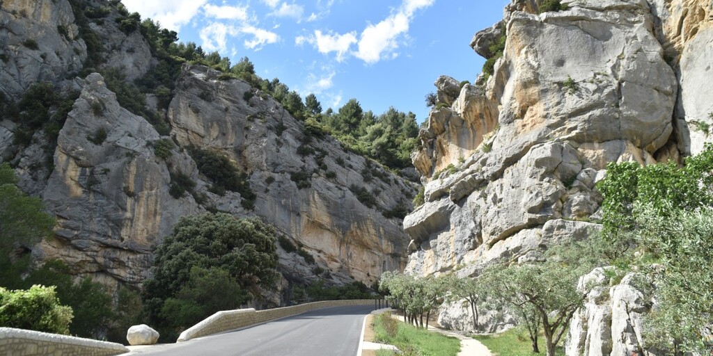
Le Gorges de la Nesque sono una profonda gola all'ombra del Mont Ventoux. Tra Villes-sur-Auzon e Monieux, una bella strada attraversa la gola con una vista spettacolare sul fiume che si snoda nella campagna quattrocento metri più in basso. Non è così affollato qui come nell'Ardèche o nel Verdon, quindi puoi facilmente fermarti ovunque per goderti il panorama. Sul Belvédère si ha una vista impressionante sul Rocher du Cire di fronte e sulla gola 300 metri più in profondità.
Alla confluenza dei fiumi Anary e Toulourenc, circondato da colline, dominato dalle rovine del castello e dal Mont Ventoux, il villaggio medievale di Reilhanette si trova a meno di due chilometri a ovest di Montbrun-les-Bains. Durante il Medioevo, era un luogo strategico che domina la valle del Toulourenc. Secoli dopo, Reilhanette ospitò uno dei due posti di controllo del fuoco della forza d'attacco nucleare francese, successivamente trasferita sull'altopiano d'Albion.
Da Reilhanette si segue per alcuni chilometri il Toulourenc. Poi la strada sale al Col de Veaux (386 m). La strada è ampia e in perfette condizioni e offre molti bei punti panoramici. Il Toulourenc, è un fiume di acque bianche sul fianco settentrionale del Mont Ventoux, e segna il confine tra i dipartimenti di Vaucluse e Drôme. Nasce nei pressi di Montbrun-les-Bains e dopo 30 km sfocia nell'Ouvèze nel territorio di Entrechaux. A monte ea valle della frazione di Veaux, il fiume ha scavato gole profonde fino a 100 metri.
La cappella di Notre-Dame de la Consolation a Pierrelongue si trova su una roccia alta 25 m nel centro del villaggio, sul sito di un antico castrum medievale.
Pierrelongue deve il suo nome a questa roccia che domina il villaggio. Su questa roccia nel 1428 furono costruite una prigione e una prima cappella dedicata a San Giuseppe. Nel 1864 si prevedeva di sostituire i ruderi con un santuario dedicato alla Vergine. I lavori iniziarono nel 1900 e durarono cinque anni, con la costruzione di una scala monumentale intorno alla roccia, una cripta dedicata a San Giuseppe e la costruzione della cappella Notre-Dame de-la-Consolation. Al di sotto della navata, la cripta contiene la tomba dell'abate e ospita un piccolo museo di arte sacra con reperti religiosi provenienti da diverse parrocchie limitrofe.
Buis-les-Baronnies è una ridente cittadina nel Parco Naturale Regionale delle Baronnies Provençales. È circondato da prati, campi di lavanda e uliveti. La suggestiva piazza del mercato, con la sua affascinante fontana, è circondata da una galleria ad archi del XV secolo e da facciate colorate.
Le vecchie case ei resti della parte storica del XIV secolo danno l'impressione di essere nel Medioevo.
Le Gorges d'Ubrieux, una riserva naturale protetta a 3 chilometri da Buis-les-Baronnies, offre un parco giochi ricco e vario per gli amanti dell'arrampicata, del nuoto e delle escursioni. Lungo l'Ouvèze, che scorre lentamente tra la strada e la falesia rocciosa, il sito è un punto di alta arrampicata nelle Baronnies, con molte vie divise in diversi settori di arrampicata su entrambi i lati del fiume.
Si segue la bella strada lungo l'Ouvèze. Il fiume nasce nelle Prealpi francesi, nel Massif des Baronnies e sfocia nel Rodano.
Tra i vigneti e gli ulivi, con una splendida vista sul Massif des Baronnies, si può godere non solo del bellissimo paesaggio, ma anche della strada tortuosa che non per niente è stata designata come strada turistica dalla Michelin.
E così ti avvicini gradualmente a Nyons dove lasci brevemente la pista principale per dare un'occhiata al romanzo di Pont. Questo ponte di puro stile romano è un arco unico lungo 43 m e alto 18 m nel punto più alto. Costruito tra il 1341 e il 1409, è ora classificato come monumento storico dal 1925.

 Collegamenti
  Utilizzo
 Vuoi scaricare questo percorso?
Puoi scaricare il percorso gratuitamente senza un account MyRoute-app. Per farlo, apri il percorso e fai clic su 'Salva con nome'. Vuoi modificare questa rotta?
Nessun problema, inizia aprendo il percorso. Segui il tutorial e crea il tuo account MyRoute-app personale. Dopo la registrazione, la tua prova inizia automaticamente.  Disclaimer
L'utilizzo di questo percorso GPS è a tue spese e rischio. Il percorso è stato accuratamente composto e controllato da un RouteXpert accreditato dall'app MyRoute per l'utilizzo su TomTom, Garmin e navigazione dell'app MyRoute.
Ciononostante potrebbero essersi verificati cambiamenti a causa di mutate circostanze, deviazioni stradali o chiusure stagionali. Si consiglia pertanto di controllare ciascun percorso prima dell'uso.
Utilizzare preferibilmente la tracklog del percorso nel sistema di navigazione. Maggiori informazioni sul l'uso dell'app MyRoute può essere trovato sul sito Web in 'Community' o 'Academy'.

Auvergne Rhone Alpes
Informazioni su questa regione
L'Alvernia-Rodano-Alpi (in francese Auvergne Rhône-Alpes, in occitano Auvèrnhe Ròse Aups, in francoprovenzale Ôvèrgne-Rôno-Arpes) è una delle regioni della Francia.
Istituita nel 2016 in seguito alla riforma territoriale del 2014 aggregando le precedenti regioni Alvernia e Rodano-Alpi ed assumendo provvisoriamente il nome attuale, divenuto poi definitivo il 30 settembre 2016, è suddivisa in dodici dipartimenti più la metropoli del suo capoluogo, Lione, con altre città principali della regione che sono Saint-Étienne, Grenoble, Villeurbanne e Clermont-Ferrand.
Composta dai dipartimenti di Ain (01), Allier (03), Ardèche (07), Cantal (15), Drôme (26), Isère (38), Loira (42), Alta Loira (43), Puy-de-Dôme (63), Rodano (69), Savoia (73) e Alta Savoia (74), sono inclusi nella regione 242 cantoni e 4189 comuni ed è la seconda regione francese per importanza in termini di PIL.
Leggi di più su Wikipedia
Istituita nel 2016 in seguito alla riforma territoriale del 2014 aggregando le precedenti regioni Alvernia e Rodano-Alpi ed assumendo provvisoriamente il nome attuale, divenuto poi definitivo il 30 settembre 2016, è suddivisa in dodici dipartimenti più la metropoli del suo capoluogo, Lione, con altre città principali della regione che sono Saint-Étienne, Grenoble, Villeurbanne e Clermont-Ferrand.
Composta dai dipartimenti di Ain (01), Allier (03), Ardèche (07), Cantal (15), Drôme (26), Isère (38), Loira (42), Alta Loira (43), Puy-de-Dôme (63), Rodano (69), Savoia (73) e Alta Savoia (74), sono inclusi nella regione 242 cantoni e 4189 comuni ed è la seconda regione francese per importanza in termini di PIL.
Visualizza regione
 Statistiche
  129
129Quantità di recensioni RX (Auvergne Rhone Alpes)
 57076
57076Quantità di visitatori (Auvergne Rhone Alpes)
 7123
7123Quantità di download (Auvergne Rhone Alpes)
 Indirizza le collezioni in questa regione
 Le 24 vie alpine più belle
Le Alpi Le Alpi sono una catena montuosa in Europa, che si estende dalla costa mediterranea francese a sud-ovest alla pianura pannonica a est. L'area della catena montuosa è più di 200.000 km².
In altre parole Passi e Strade di Montagna!
Guidare attraverso le montagne è fantastico! Soprattutto sui passi di montagna con tornanti e strade strette e tortuose. Ad ogni curva un panorama diverso da cui godere. Ci sono molti bei passi di montagna nelle Alpi.
Una selezione che è stata inserita anche in questi percorsi:
Il Passo dello Stlevio:
Il Passo dello Stelvio, noto anche come Passo dello Stelvio, è conosciuto principalmente per la tappa del Giro d'Italia. A causa della lunghezza e del dislivello, questo passaggio è considerato uno dei test più duri del ciclismo. Il Passo dello Stelvio raggiunge un'altezza massima di 2758 metri ed è quindi uno dei più alti delle Alpi. Il passo collega i comuni di Bormio e Prato Allo Stelvio. In inverno il passo è chiuso per abbondanti nevicate.
Il Passo Resia:
Il Passo Resia, noto anche come Passo di Resia, collega lo stato austriaco del Tirolo con la provincia italiana dell'Alto Adige. Il passo raggiunge un'altezza massima di 1.504 metri ed è stato uno dei più importanti collegamenti nord-sud delle Alpi negli ultimi secoli. Il passo era utilizzato molto prima dell'epoca romana. Lungo la strada passerai diversi punti salienti e cimeli storici. Uno dei punti forti è il Lago di Resia. Questo lago è stato creato dopo la costruzione della diga e ha completamente sommerso il paese di Graun. L'unica cosa che lo ricorda è la torre dell'orologio in mezzo al lago.
Col du Galibier:
Il passo di montagna francese Col du Galibier collega le città di Saint-Michel-de-Maurienne e Briançon tramite il Col du Lautaret a sud e il Col du Télégraphe a nord. Il valico fa parte del Tour de France ed è molto temuto, in quanto raggiungibile solo attraverso gli altri due passi alpini. Il passo raggiunge un'altezza massima di 2646 metri. Da lì puoi fare una passeggiata fino al punto panoramico a 2704 metri. Qui puoi ammirare le vette del Grand Galibier, del Monte Bianco e della Meije.
La Strada alpina del Grossglockner:
Con un'altezza di 3798 metri il Grossglockner è la montagna più alta dell'Austria. Per godere appieno di questa imponente montagna, è possibile percorrere la Strada alpina del Grossglockner e il passo di accompagnamento. Il percorso parte da Bruck am Grossglockner e termina a Heiligenblut. Ovviamente puoi guidare in due direzioni. Il passo raggiunge un'altezza massima di 2504 metri ed è chiuso in inverno a causa di abbondanti nevicate. Lungo il percorso si superano diverse soste con attività ludiche, punti informativi, rifugi e punti panoramici. Si consiglia vivamente una visita al ghiacciaio Kaiser-Franz-Josefs-Höhe e Pasterzen.
Il Col d'Izoard:
Come il Col du Galibier, anche il Col d'Izoard fa parte di una tappa del Tour de France. Il valico collega Briançon con la valle del fiume Guil. Il passo si trova in parte nel Parco Naturale Regionale del Queyras e raggiunge un'altezza massima di 2360 metri. La particolarità del Col d'Izoard è il paesaggio arido e roccioso. A volte sembra di guidare un'auto sulla luna! Lungo il percorso è possibile sostare in più punti per godere del bellissimo panorama.
Il Passo del Bernina:
Il Bernina Express è uno dei treni ferroviari più famosi della Svizzera e delle Alpi. Il percorso è bellissimo e in parte inserito nella World Heritage List dell'UNESCO. Parallelo alla ferrovia si trova il passo del Bernina, che collega la Val Veltlin con la Val d'Egandin. Questa bellissima strada alpina ha una lunghezza totale di 56 chilometri e raggiunge un'altezza massima di 2328 metri. Lungo il percorso si può godere della vista sul ghiacciaio del Morteratsch.
Il Passo Sella:
Il Passo Sella, detto anche Passo di Sella, porta su uno dei gruppi montuosi più imponenti delle Dolomiti: il massiccio del Sella. Il passo collega la Valle di Fassa con la Val Gardena e raggiunge un'altezza massima di 2236 metri. A questa altezza si trova anche il confine delle province italiane del Trentino e di Bolzano. Lungo il percorso si può godere della vista di questo spettacolare mondo alpino. Ammirate, ad esempio, le tre cime del massiccio del Sasso Lungo, il massiccio del Sella o le vette della Marmolada. Si può percorrere anche il passo Sella in abbinamento al passo Gardena, passo Pordoi e passo Campolongo.
Il Passo del Grimsel:
Il passo del Grimsel collega il Goms nel Vallese con la Halistal nell'Oberland bernese. Il passo raggiunge un'altitudine massima di 2165 metri ed è chiuso in inverno per nevicate. Nel corso dei secoli, il valico ha svolto un ruolo importante nel commercio tra la Svizzera e l'Italia. Ora sono principalmente i serbatoi ad avere una funzione importante. Questi sono usati per generare elettricità. Il paesaggio che attraversi è aspro, roccioso e impressionante. In cima al passo si trovano un hotel e un ristorante con uno speciale parco delle marmotte. Anche il Dodensee (Totensee) si trova qui. Questo lago deve il suo nome ai tanti soldati morti al tempo di Napoleone.
Il Passo del San Gottardo:
Il Passo del San Gottardo, noto anche come Passo del San Gottardo e San Gottardo, collega le città svizzere di Airolo e Andermatt. Il passo di montagna e il relativo tunnel sono particolarmente conosciuti tra i vacanzieri che guidano dalla Svizzera all'Italia. Ma dove la maggioranza opta per il tunnel, è proprio il pass che completa davvero la vacanza. Il Passo del San Gottardo ha una lunghezza di circa 26 chilometri e raggiunge un'altezza massima di 2106 metri. Il percorso è bellissimo e ti porta lungo antichi borghi e bei panorami.
La Strada dell'Alta Silvretta e il Passo Silvretta:
La Valle di Paznaun in Tirolo e il Montafon nel Vorarlberg sono collegati dalla Strada alpina della Silvretta. Il percorso ha una lunghezza di 22,3 chilometri e conduce da Galtür a Partenen in 34 tornanti, attraverso il Bielerhöhe alto 2032 metri. In questo punto si trova anche il Silvrettasee, dove si può fare una bella passeggiata. Il passo è chiuso in inverno per nevicate.
Il Passo del Sempione:
Proprio come il Passo del San Gottardo, anche molti vacanzieri percorrono ogni anno il Passo del Sempione. Questo valico collega la Valle del Rodano nel Canton Vallese con la Valle d'Ossola in Piemonte. Il passo è aperto tutto l'anno e raggiunge un'altezza massima di 2005 metri. Lungo il percorso si passano una serie di edifici, tra cui il famoso Hospiz del Sempione del 1825. L'hospiz è gestito dai monaci di San Bernardo. Dal punto più alto del passo sono possibili tutti i tipi di percorsi escursionistici e incontrerete anche un albergo dove potrete pernottare.
Il Passo Gerlos:
Il Passo Gerlos collega la Valle del Salzach nel Salisburghese con la Valle Zillertal in Tirolo. Il passo fa parte della Gerlos Alpenstraße e attraversa il Parco Nazionale Alti Tauri. Lungo il percorso si possono godere splendidi panorami dei dintorni. Il passo ha una lunghezza di 12 chilometri e raggiunge un'altezza massima di 1531 metri. Un giro sul Gerlos Pass può essere idealmente combinato con una visita al Krimmler Wasserfälle.
Il Gran San Bernardo:
Il Colle del Gran San Bernardo, meglio conosciuto come Col du Grand Saint Bernard, collega la provincia italiana della Valle d'Aosta con il cantone svizzero del Vallese. Il passo è uno dei più alti della Svizzera e raggiunge un'altezza massima di 2469 metri. Come molti altri passi di montagna in questo elenco, anche il Gran San Bernardo è stato utilizzato per secoli come strada di collegamento. Il passo prende il nome dai cani di San Bernardo che aiutavano i viaggiatori bloccati insieme ai monaci. Il passo è chiuso in inverno.
La Strada alpina del Passo Rombo:
La Strada alpina del Passo Rombo collega le località di Sölden nella Ötztal e Merano in Alto Adige. I pedaggi devono essere pagati sulla tratta Hochgurgl - Moos. Attraverso una strada di montagna con circa 60 tornanti si guida attraverso un bellissimo mondo di montagne. Con l'esperienza del Passo Rombo puoi conoscere meglio la storia, la strada e l'ambiente attraverso varie stazioni. È inoltre possibile visitare il museo Top Mountain Crosspoint.
Col de l'Iseran:
Con un'altezza massima del passo di 2770 metri, il Col l'Iséran è uno dei passi di montagna più alti delle Alpi. Il passo collega Bourg-Saint-Maurice con Bonneval-sur-Arc. Attraverso una strada ricca di tornanti si passa, tra l'altro, Val-d'Isère e una valle laterale della Maurienne che si trova interamente nel Parco Nazionale della Vanoise. È possibile avvistare animali come marmotte e camosci e c'è anche un ristorante con una cappella in cima al passo.
Il Passo Gavia:
Il Passo Gavia (italiano Passo di Gavia) è un passo di montagna nelle Alpi italiane, nella regione Lombardia.
È una delle strade di passaggio più alte d'Europa. La strada conduce attraverso l'incontaminato Parco Nazionale dello Stelvio. La strada fu costruita durante la prima guerra mondiale per rifornire i soldati italiani che combatterono nella zona di confine italo-austriaca. L'altezza del passo è una delle più belle delle Alpi. Ecco il grande Lago Bianco con, a nord, il monte San Matteo (3684 metri). Il Lago Nero è leggermente più basso sul lato sud del passo. Qui il gruppo montuoso dell'Adamello determina il panorama. Ci sono molte passeggiate ben segnalate nella zona. Durante l'inverno il passo è chiuso a causa delle abbondanti nevicate. Il passo è spesso chiuso fino a maggio e giugno a causa della grande quantità di neve.
Il promotore ha selezionato i 24 percorsi alpini più belli che ha tracciato negli ultimi anni.
I percorsi attraversano:
Francia
Austria
Svizzera
Italia
Le strade più belle, i panorami più belli, i punti panoramici più belli. Le montagne più alte, le discese più veloci, tornante dopo tornante, e chi più ne ha più ne metta.
Se vai in vacanza in questa regione, approfittane, TUTTI i percorsi in questa raccolta sono stati controllati e resi uguali per TomTom, Garmin e MyRoute-app Navigation da un'app MyRoute RouteXpert.
Divertiti con questa collezione e mentre guidi uno di questi percorsi. Goditi tutta la bellezza che le Alpi e le Dolomiti hanno da offrire. Clicca su “Visualizza percorso” per leggere la recensione del percorso scelto.
Vorrei conoscere le vostre conclusioni sui percorsi.
Visualizza raccolta percorsi
25 magnifici sentieri in Francia
Questa raccolta di percorsi MRA contiene 25 bellissimi percorsi motociclistici in diverse parti della Francia, come le Ardenne, l'Alsazia, il Vercors, la Drôme, l'Ardèche, la Costa Azzurra, le Gorges du Verdon, l'Ariège, la Dordogna e la Bretagna.
I percorsi sono stati creati con cura da Bert Loorbach, che è lui stesso un appassionato motociclista. Ha vissuto in Francia per un anno e mezzo, durante il quale si è dedicato alla mappatura delle strade secondarie sconosciute e belle della Francia soprattutto per i motociclisti.
I percorsi sono raggruppati nella parte 1 di Motortourgids France della casa editrice Kosmos e ora sono disponibili anche in MyRouteApp.
Ho ripreso i percorsi in MRA e a volte li ho leggermente modificati per renderli ancora più interessanti per il motociclista.
Visualizza raccolta percorsi