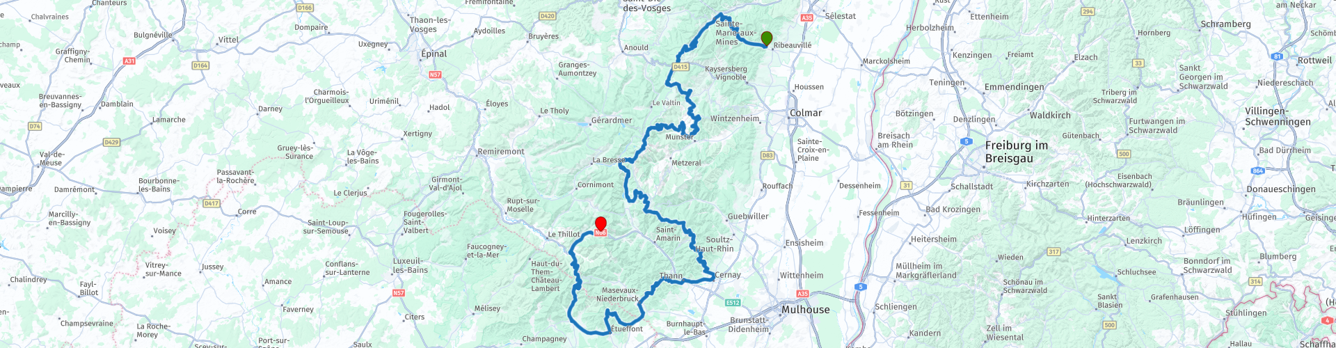
R04 Ribeauville to Urbes

Diese Route wurde erstellt von:
RouteXpert Hans van de Ven (Mr.MRA)
Letzte Änderung: 18-04-2021
 Routenzusammenfassung
 Ausgangspunkt: Ribeauville, Au Cheval Blanc
Endpunkt: Urbès, Moto-Hotel du Col de Bussang
Die Route wird für Garmin, TomTom und MRA Navigation ausgeglichen.
Gute Reise.
 Diese Route teilen


Animation

Urteil


Dauer
7h 48m

Reisemodus
Auto oder Motorrad

Entfernung
232.16 km

Länder

 RouteXpert-Überprüfung
 Diese Route führt Sie nach Ribeauvillé nach Urbès. Auf dem Weg passieren Sie nicht weniger als 11 Cols, einschließlich des Grand Ballon.
Diese Route ist voller Kurven, von Dorf zu Dorf, von Col zu Col, mit ein paar schönen Zwischenstopps für einen Drink und eine Mahlzeit. Auch wie könnte es sonst einige schöne Aussichtspunkte entlang der Route sein, an denen Sie anhalten, um ein Foto zu machen.
Während des Ersten und Zweiten Weltkriegs gab es auch heftige Kämpfe in den Vogesen und im Elsass. Die Befreiung verlief viel reibungsloser als in den Ardennen. Angesichts der Anzahl der Militärfriedhöfe, die Sie unterwegs passieren, deutet dies bereits darauf hin. Ein Besuch des Musee Memorial du Veil und des historischen Franko-Allemand de la Grande Guerre du Hartmannswillerkopf lohnt sich auf jeden Fall.
Ich habe den größten Teil dieser wunderbaren Route gefahren, weshalb ich diese Route mit 5 Sternen bewerte. Auf der Spitze des Grand Ballon, auf 1.425 Metern, haben Sie einen weiten Blick. Der Abstieg besteht aus würzigen Haarnadelkurven.


 Links
Links  Nutzung
 Möchten Sie diese Route herunterladen?
Sie können die Route ohne MyRoute-App-Konto kostenlos herunterladen. Öffnen Sie dazu die Route und klicken Sie auf 'Speichern unter'. Möchten Sie diese Route bearbeiten?
Kein Problem, starten Sie mit dem Öffnen der Route. Folgen Sie dem Tutorial und erstellen Sie Ihr persönliches MyRoute-App-Konto. Nach der Registrierung startet Ihre Testversion automatisch.  Haftungsausschluss
Die Nutzung dieser GPS-Route erfolgt auf eigene Kosten und Gefahr. Die Route wurde sorgfältig von einem MyRoute-App akkreditierten RouteXpert für die Verwendung mit TomTom, Garmin und MyRoute-App Navigation zusammengestellt und geprüft.
Durch geänderte Umstände, Straßenumleitungen oder saisonale Sperren können sich dennoch Änderungen ergeben haben. Wir empfehlen daher, jede Route vor der Nutzung zu überprüfen.
Verwenden Sie vorzugsweise den Routentrack in Ihrem Navigationssystem. Mehr Informationen zu den Die Nutzung der MyRoute-App finden Sie auf der Website unter 'Community' oder 'Academy'.

Grand Est
Über diese Region
Grand Est (französisch [ɡʁɑ̃t‿ɛst]), deutsch Großer Osten, ist eine französische Region, die am 1. Januar 2016 aus dem Gebiet der vorherigen Regionen Elsass (Alsace), Lothringen (Lorraine) und Champagne-Ardenne entstand. Als vorläufiger Name wurde zunächst Alsace-Champagne-Ardenne-Lorraine verwendet. Dieser wurde zum 1. Oktober 2016 vom Staatsrat (Conseil d’État) durch den aktuellen Namen ersetzt.Grand Est ist mit 57.433 km² die viertgrößte Region (ohne Übersee-Regionen) und hat 5.550.389 Einwohner (Stand: 2018), womit sie die sechstgrößte Region nach der Einwohnerzahl ist. Verwaltungssitz und bevölkerungsreichste Stadt ist Straßburg. Die Region Grand Est unterteilt sich in die zehn Départements Ardennes (08), Aube (10), Bas-Rhin (67), Haute-Marne (52), Haut-Rhin (68), Marne (51), Meurthe-et-Moselle (54), Meuse (55), Moselle (57) und Vosges (88). Sie grenzt (im Uhrzeigersinn) an Belgien, Luxemburg, Deutschland, die Schweiz sowie die Regionen Bourgogne-Franche-Comté, Île-de-France und Hauts-de-France.
Besonders im Elsass kam es im Vorfeld zu Protesten gegen die Bildung dieser neuen Region. 2019 wurde beschlossen, dass die beiden Départements des Elsass Haut-Rhin (68) und Bas-Rhin (67) ab dem 1. Januar 2021 wieder als Europäische Gebietskörperschaft Elsass (Collectivité européenne d’Alsace) mit einem speziellen, in Frankreich einzigartigen Status zusammengefasst werden.
Lesen Sie mehr auf Wikipedia
Besonders im Elsass kam es im Vorfeld zu Protesten gegen die Bildung dieser neuen Region. 2019 wurde beschlossen, dass die beiden Départements des Elsass Haut-Rhin (68) und Bas-Rhin (67) ab dem 1. Januar 2021 wieder als Europäische Gebietskörperschaft Elsass (Collectivité européenne d’Alsace) mit einem speziellen, in Frankreich einzigartigen Status zusammengefasst werden.
Region anzeigen
 Statistik
  84
84Anzahl der RX-Bewertungen (Grand Est)
 42696
42696Anzahl der Besucher (Grand Est)
 14338
14338Anzahl der Downloads (Grand Est)
 Routensammlungen in dieser Region
 25 herrliche Wanderwege in Frankreich
Diese MRA-Routensammlung enthält 25 wunderschöne Motorradrouten in verschiedenen Teilen Frankreichs, wie den Ardennen, dem Elsass, Vercors, der Drôme, der Ardèche, der Cote d'Azure, den Gorges du Verdon, der Ariège, der Dordogne und der Bretagne.
Die Routen wurden von Bert Loorbach, der selbst begeisterter Motorradfahrer ist, sorgfältig erstellt. Er lebte anderthalb Jahre in Frankreich und widmete sich während dieser Zeit der Kartierung der unbekannten und schönen Nebenstraßen Frankreichs speziell für Motorradfahrer.
Die Routen sind im Motortourgids France Teil 1 des Kosmos Verlags gebündelt und jetzt auch in MyRouteApp verfügbar.
Ich habe die Strecken in MRA übernommen und manchmal etwas angepasst, um sie für den Motorradfahrer noch interessanter zu machen.
Routensammlung anzeigen
11-tägiger Ausflug aus den Niederlanden
8 Länder in 11 Tagen; Niederlande, Deutschland, Österreich, Italien, Schweiz, Frankreich, Luxemburg und Belgien. Diese Streckensammlung besteht aus 10 Strecken, die ich im Sommer 2019 mit Freunden gefahren bin.
Der Start ist in Geldermalsen Niederlande, die ersten 7 Tage fahren Sie durch die Niederlande, Deutschland, Österreich, Italien, die Schweiz, Frankreich und ein Stück Luxemburg mit Übernachtungen in Hotels.
Die letzten drei Tage bleiben Sie in Barweiler (D) in der Eifel und fahren zwei wunderschöne Touren durch die Eifel, Luxemburg und Teile der belgischen Ardennen.
Es gibt keine Autobahn in den Routen, nur schöne Provinz- und Landstraßen, viele schöne Pässe mit schönen Panoramen.
Überprüfen Sie vor Ihrer Abreise, ob die Pässe geöffnet sind.
Dies sind Routen für erfahrene Fahrer.
Routensammlung anzeigen