Fortified Churches Roundtrip around Vervins

Deze route is gemaakt door:
RouteXpert Jan Koelstra - Senior Rx
Laatst gewijzigd: 25-10-2024
 Route Samenvatting
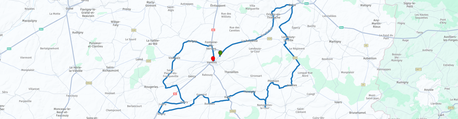
 Je start de rondtocht in Vervins op de parkeerplaats van de Intermarché, waar je tevens kunt tanken.
Onderweg is er nauwelijks gelegenheid in de dorpen om iets te nuttigen en ben je aangewezen op de omliggende plaatsen Hirson en Marle voor koffie respectievelijk lunch. Dit is in de rondtocht aangegeven.
De toertocht krijgt een waardering van vier sterren. De wegen zijn prima te berijden, maar de grijze dorpen en het eentonige landschap boeien niet echt. Daarentegen levert de grote verscheidenheid van de versterkte kerken een welkome aanvulling.
Bijzonderheden:
Soms hebben de gebruikers van TomTom een kleine afwijking in de route. Dit veroorzaakt overigens geen verstoring van de route zelf. Let op bij rp5 en rp21.
 Deel deze route


Animation

Beoordeling


Duur
7h 27m

Transportmodus
Auto of motor

Afstand
80.25 km

Landen

 RouteXpert Review
 De dorpen liggen hier dicht bij elkaar en je kunt veelal de kerktoren zien van het naastgelegen dorp. In vroegere tijden was dit zelfs levensreddend. Als er een aanval op handen was dan werden de kerkklokken geluid die in de wijde omtrek te horen waren. Het volgende dorp luidde ook de klokken en het daarop volgende dorpen, zodat iedereen zich op tijd in veiligheid kon brengen. De dorpsbewoners en soms ook soldaten, trokken met have en goed naar de kerk.
Men klom omhoog via de nauwe trapopgang de toren in waarna men in een grotere ruimte kwam waar men dagen kon verblijven. Sommigen kerken beschikten over meerdere verdiepingen. Zelfs het vee werd de smalle trap opgedreven. De ruimten waren niet bijzonder groot en met velen was het snel overvol. Er was een rookkanaal zodat er gekookt kon worden en er waren houten afscheidingen waar men de meest waardvolle dieren kon huisvesten. In de toren(s) waren smalle (schiet)sleuven aangebracht waar de dorpsbewoners de vijand kon beschieten of pek of olie naar beneden konden gooien om zich zo enigszins te verdedigen.
Deze rondgang langs de versterkte kerken concentreert zich rondom de stad Vervins. De route begint en eindigt dan ook in Vervins, Het is een gezellig stadje midden in het mooie natuurgebied Thiérache in de Aisne. Het stadje is ontstaan in de middeleeuwen, maar een groot gedeelte werd in de 16e eeuw afgebrand. Daarna is er veel herbouwd en ook na de eerste wereldoorlog zijn er veel gebouwen verwoest en vervolgens weer gerestaureerd. De nieuwe huizen zijn vooral in een Art Deco stijl gebouwd met mooie gevels en gekleurde muren. Je vindt er kortom, een grote diversiteit aan architectonische stijlen en het is het dan ook zeker waard om de hele stad te verkennen. Eén van de belangrijkste bezienswaardigheden is de mooie kerk van Vervins en ook het gemeentehuis en het station zijn erg mooi.
Het platteland is echter niet zo spannend; Je verlegt je focus op het ontwaren van een versterkte kerk verderop. Meestal zie je ze al van grote afstand. Doordat de dorpen dicht bij elkaar liggen, belooft de route enigszins onvoorspelbaar te zijn en loopt de weg over het algemeen binnen door, langs kerkenpaden en boerenweggetjes. Bij de mooiste exemplaren is extra tijd opgenomen. In deze streek is het vinden van een tankstation, een bar of restaurant een uitdaging en je wordt geadviseerd je tank te vullen bij aanvang. Voor het nuttigen van etenswaar is een picknick uiteraard altijd mogelijk, maar voor een geopende bar, cafetaria of restaurant kan even van de route worden afgeweken. Dit is overigens in de route zelf aangegeven.


 Links
Links  Gebruik
 Deze route downloaden?
Je kan de route gratis, zonder MyRoute-app account downloaden. Om dit te doen, open de route en klik op 'opslaan als'. Deze route wijzigen?
Geen probleem, open eerst de route. Volg de tutorial en maak je eigen MyRoute-app account aan. Na registratie, start je trial automatisch.  Disclaimer
Gebruik van deze gps-route is voor eigen rekening en risico. De route is met zorg samengesteld en door een MyRoute-app geaccrediteerde RouteXpert gecontroleerd voor gebruik op zowel TomTom, Garmin als MyRoute-app Navigation.
Door gewijzigde omstandigheden, wegomleidingen of seizoensafsluitingen kunnen er toch veranderingen zijn ontstaan. Daarom adviseren wij iedere route voor gebruik te controleren.
Gebruik bij voorkeur de routetrack in je navigatiesysteem. Meer uitleg over het gebruik van MyRoute-app kun je vinden op de website bij ‘Community’ of ‘Webinars’.

Hauts de France
Over deze Regio
Hauts-de-France (Picardisch: Heuts-d'Franche) is een regio van Frankrijk. De regio is op 1 januari 2016 ontstaan door de samenvoeging van de regio's Nord-Pas-de-Calais en Picardie. Op 6 en 13 december 2015 waren er de eerste verkiezingen voor de 170 leden van de eerste Regionale Raad van Nord-Pas-de-Calais-Picardie en de andere nieuwe en ongewijzigde Franse regio's.
De regio omvat een gebied van 31.813 km² met een bevolking van 5.973.098 in 2015.
Lees meer op Wikipedia
De regio omvat een gebied van 31.813 km² met een bevolking van 5.973.098 in 2015.
Bekijk regio
 Statistieken
  38
38Aantal RX reviews (Hauts de France)
 34110
34110Aantal bezoekers (Hauts de France)
 2652
2652Aantal downloads (Hauts de France)
 Route Collecties in deze regio
 24 Magnificent routes in France
Dat Frankrijk één van de mooiste en beste toerlanden is staat als een paal boven water. Het biedt een ongelooflijk gevarieerd landschap met goede wegen en een prettig klimaat. Het is niet voor niets dat je er zoveel motorrijders ziet. Mijn vorige collectie van 25 routes in Frankrijk (25 Magnificent routes in France) waren gebaseerd op de routebeschrijvingen uit de Motortourgids Frankrijk deel 1 gemaakt door Bert Loorbach.
Deze collectie van 24 routes komt uit Motortourgids Frankrijk deel 2. Bij deze collectie is er een verschil gemaakt tussen aanrijroutes en motortochtentochten in een bepaald gebied. De aanrijroutes kunnen ook gebruikt worden in combinatie met de routes uit Motortourgids Frankrijk deel 1
De routes zijn soms iets aangepast op basis van de tips die Bert Loorbach geeft in zijn beschrijving, of vanwege een andere plaats om te overnachten, of om de minimale lengte van 2 uur voor de MRA Library te halen. Bij elke route staat in de review een meer gedetailleerde beschrijving, inclusief opties om te overnachten of bezienswaardigheden onderweg, welke ook zijn aangegeven met een POI en indien mogelijk met een korte omschrijving.
Er zijn voor een aantal gebieden 2 of meer routes gemaakt, zoals voor de Bourgogne, Auvergne, De Alpen, Tarn en Cévennen en Nord-Pas de Calais. Deze routes zijn mooi te combineren in een meerdaagse tocht.
Bekijk Route Collectie
De 10 meest gedownloade routes in Frankrijk van RouteXpert Catherine De Groote
Hallo en welkom bij deze verzameling van de Top 10 MyRoute-app gedownloade routes in Frankrijk.
Er zal binnenkort een geweldig nieuw evenement aankondigen worden, waarbij al deze routes gereden kunnen worden.
Download ze nu allemaal en plaats ze in een nieuwe map "Top 10", zodat je ze altijd bij de hand hebt.
Als je in de tussentijd een van deze routes gaat rijden, track ze dan met de MRA Mobile App of met MRA Navigation. Maak onderweg wat foto's (momenten), want deze zullen handig zijn.
Maak een reisverhaal van je Top 10 gereden routes en voeg de opgenomen track hieraan toe.
Er zullen ook een aantal geweldige prijzen worden aangeboden, dus houd de MRA-RouteXperts pagina en je mail in het oog.
Bekijk Route Collectie