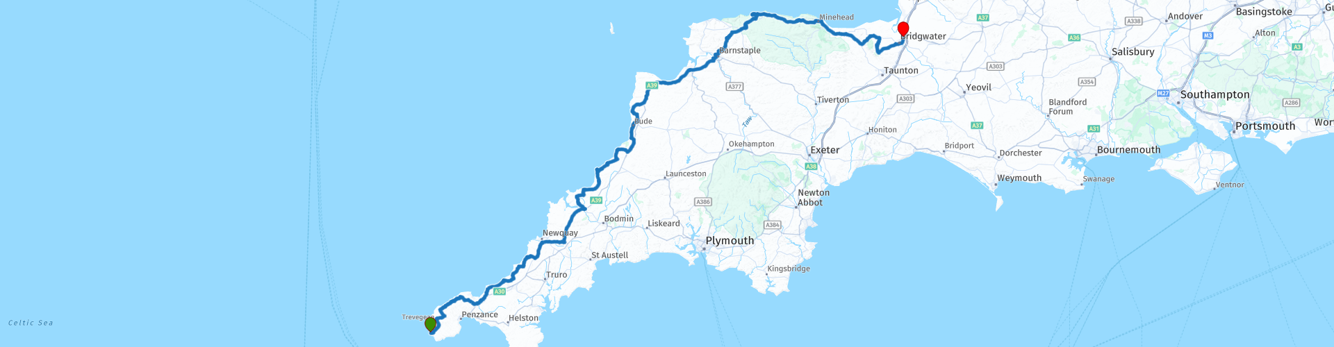
01 Lands End to Bridgewater via Exmoor

Deze route is gemaakt door:
RouteXpert Nick Carthew - (MRA Master)
Laatst gewijzigd: 27-10-2021
 Route Samenvatting
 Ik zou aanraden om 08:00 uur te vertrekken vanaf Lands End Hotel, zodat je voldoende tijd hebt om alle bezienswaardigheden onderweg te bekijken. Vergeet niet het "End to Enders"-boek te ondertekenen bij de hotelreceptie. Nog een tip: velen die op de "LeJog" rijden, rijden voor een goed doel, als jij dit bent, vertel de parkeerwachter dan dat je meedoet aan een liefdadigheidsrit en je krijgt gratis toegang.
Deze eerste route gaat door Cornwall, Devon en Somerset in, voornamelijk langs de kust om u spectaculaire uitzichten te bieden, enkele geweldige wegen om op te rijden en interessante dingen om te zien.
Dit levert deze route 5***** sterren op.
 Deel deze route


Animation

Beoordeling


Duur
11h 23m

Transportmodus
Auto of motor

Afstand
348.27 km

Landen

 RouteXpert Review
 De levendige identiteit van Cornwall is geëvolueerd van een geschiedenis die 3000 jaar teruggaat en een rijke traditionele cultuur waarvan een groot deel nog steeds leeft en ademt door de locaties en landschappen die tegenwoordig in de regio te vinden zijn. Mijnbouw heeft een grote rol gespeeld in de geschiedenis van Cornwall en hoewel de meeste mijnen nu gesloten zijn, is er nog steeds bewijs aan de oppervlakte van waar ze waren. Een groot deel van het eerste deel van deze route bevindt zich op een werelderfgoedlocatie die het belang van het industriële erfgoed van Cornwall erkent.
Het Cornish Engine House is een opvallende structuur die in de afgelopen 200 jaar is gebouwd om de waterpompmotoren of kronkelende motoren te huisvesten die de mijnen eronder bedienen. ... Veel van de motorhuizen werden na de tweede wereldoorlog ook gebruikt als schietoefeningen en opgeblazen door de Canadezen of Amerikanen (helaas met toestemming). Deze route voert langs goede voorbeelden van machinehuizen, namelijk Wheal Hearle en Carn Galver en vervolgens door de havens die worden gebruikt voor de export van het waardevolle erts.
De route volgt de kust en bezoekt Port Isaac waar de tv-serie Doc Martin werd gefilmd. Port Isaac, was een drukke kusthaven van de middeleeuwen tot het midden van de 19e. Eeuw toen het een actieve haven was waar ladingen zoals steen, kolen, hout en aardewerk werden geladen en gelost. Ook de visserij en de visverwerking waren belangrijk en vandaag de dag werken er nog steeds vissers van hieruit, hoewel het toerisme een steeds belangrijkere rol speelt.
Er zijn nu verschillende kustdorpen in Cornwall te zien,
Tintagel ligt slechts een paar minuten verder naar het noorden. Tintagel ligt hoog aan de ruige kust van Noord-Cornwall en heeft een spectaculair uitzicht op zee, zowel vanaf de kasteelruïne op de landtong als vanaf het eiland. Dit is een spectaculaire plek, doordrenkt van mythen en mysterie, en heeft kunstenaars en schrijvers door de geschiedenis heen geïnspireerd die het hebben geassocieerd met de legende van koning Arthur.
De pittoreske haven van Boscastle is een van de meest romantische plekken van Cornwall. De lange smalle vallei loopt naar beneden naar een steile en rotsachtige ingang naar de woeste zee daarachter. Het is een plaats met een rijke geschiedenis, geassocieerd met auteurs en kunstenaars die zijn geïnspireerd door de afgelegen ligging en ruige schoonheid, maar het is ook een werkende haven geweest, zowel voor vissers als voor steenwerkers door de jaren heen.
Crackington Haven, gelegen in een Area of Outstanding Natural Beauty, is een klein dorp met een inham die wordt gedomineerd door majestueuze kliffen. Ooit was het een kleine haven die kolen en kalksteen importeerde uit Wales, maar het ontsnapte ternauwernood aan de industriële ontwikkeling in de jaren 1800 en is nu een kleine ongerepte, bijna geheime baai.
Een koffiestop bij Widemouth Bay Cafe is een must. De brede baai, vandaar de naam, is al lang een paradijs voor surfers met de Atlantische rollers die de perfecte golf creëren. Parkeer uw fietsen direct naast het café en geniet van een kopje koffie in de openlucht. Widemouth Bay is ook het aanlandingspunt voor veel belangrijke communicatiekabels die het VK met andere landen verbinden. Er wordt gezegd dat een van deze de 'Trans-Atlantische hotline' is die Downing Street verbindt met het Witte Huis! De volgende attractie getuigt hiervan.
GCHQ Bude is een reeks satellietschotels op de kliffen net ten noorden van Bude. Geloof het of niet, deze reeks gebouwen bij Cleave Common is de thuisbasis van enkele van de meest hightech digitale beveiligings- en inlichtingenoperaties ter wereld en voert regelmatig taken uit die terrorisme voorkomen, de georganiseerde misdaad bestrijden en ons land veilig houden. Het wordt beheerd door de Britse inlichtingendienst voor signalen, officieel bekend als het Government Communications Headquarters, gewoonlijk afgekort GCHQ. Het is gelegen op een deel van het terrein van het voormalige vliegveld van de Tweede Wereldoorlog, RAF Cleave. In 1963 werd TAT-3, een onderzeese kabel die het Verenigd Koninkrijk met de Verenigde Staten verbindt, net ten zuiden van de locatie bij Cleave Common gelegd. Het Britse General Post Office (GPO) controleerde routinematig alle communicatie die langs de TAT-3-kabel ging en stuurde alle berichten door die volgens hen relevant waren voor de veiligheidsdiensten.
Vanaf GCHQ komt de route uit op de A39, die vaak wordt beschouwd als de beste motorweg in het zuidwesten. Ik zou nog een stap verder willen gaan en suggereren dat delen van de A39 enkele van de beste motorwegen in het hele VK zijn.
Lunchstop is bij de bekroonde Pelican Fish and Chip-winkel in Barnstaple. Als u Lands End om 08:00 uur verlaat, arriveert u hier rond 13:00 uur. Er is voldoende parkeergelegenheid en tafels buiten of binnen.
De A39 brengt u nu door een prachtig landschap van Devon en naar Exmoor National Park. Met slechts 693 vierkante kilometer is Exmoor een van de kleinste nationale parken van het VK. Maar wat het aan omvang mist, maakt het meer dan goed in schoonheid en verscheidenheid aan landschappen. Niet meer dan de Valley of Rocks bij Lynton. De Valley of Rocks is een dramatisch stuk kustlijn aan de noordelijke rand van Exmoor. Aangekomen in de diepe vallei, klimmen steile steile kliffen aan weerszijden van je omhoog om naar de hemel te wijzen. Of je er nu bent onder een kristalheldere blauwe lucht of stormachtige atmosferische wolken, dit is een geweldige plek om je verfrist en verjongd te voelen.
Terug naar beneden door Lynton naar het zusterstadje Lynmouth met zijn pittoreske haven en kabelbaan. De meermaals bekroonde en beroemde Lynton en Lynmouth Cliff Railway werd geopend in 1890 en is de hoogste en steilste volledig door water aangedreven spoorlijn ter wereld! De Cliff Railway verbindt de zustersteden Lynton en Lynmouth en biedt een prachtig uitzicht op de kust dat het hoogtepunt van elk bezoek zal zijn. Deze werkende erfgoedspoorweg is monumentaal, de enige volledig door water aangedreven spoorlijn in het VK en een van de slechts drie overgebleven exemplaren in de wereld!
Vanaf hier blijf je op de A39 en reis je naar het oosten, eerst door Countisbury Hill te beklimmen met een aantal van de beste uitzichten over de kust in het zuidwesten. Dit gedeelte van de A39 is geweldig voor motorfietsen met veel bochten als je langs de noordkust van Exmoor rijdt. Normaal gesproken staat er een ijscowagen geparkeerd op een grindparkeerplaats op de top van Porlock Hill, zelfs als je geen ijsje wilt, is het de moeite waard om te stoppen voor het uitzicht over het Kanaal van Bristol naar Wales.
Porlock Hill met 25% is naar verluidt de steilste A-weg in Engeland, doe het rustig aan op de weg naar beneden, want er zijn enkele scherpe bochten.
Ik heb voorgesteld om de A39 af te slaan om Minehead te bezoeken voor een kopje koffie, je bent ongeveer een uur verwijderd van het einde van de route bij Bridgewater. Minehead, genesteld tussen Exmoor National Park aan de ene kant en de Quantock Hills aan de andere kant, trekt al lang bezoekers naar de kustlocatie.
De route verlaat de A39 bij Williton en gaat naar The Quantock Hills, een gebied vol wildernis en rust. De Quantock Hills zijn een Area of Outstanding Natural Beauty (AONB), wat betekent dat het onderscheidende karakter, de natuurlijke schoonheid en het culturele erfgoed zo opmerkelijk zijn dat het in het belang van de natie is om ze te beschermen. Het gebied kreeg in 1956 de beschermde status.
Het einde van de route is bij de Premier Inn, Bridgewater. Er zijn veel hotels en B&B's; rond Bridgewater Ik heb een link voor deze onder deze recensie opgenomen.
Dus daar heb je het, de eerste dag van je LeJog is voltooid. Waarom de snelle en gemakkelijke route nemen als er zoveel te zien is op weg naar de eindbestemming.


 Links
Links  Gebruik
 Deze route downloaden?
Je kan de route gratis, zonder MyRoute-app account downloaden. Om dit te doen, open de route en klik op 'opslaan als'. Deze route wijzigen?
Geen probleem, open eerst de route. Volg de tutorial en maak je eigen MyRoute-app account aan. Na registratie, start je trial automatisch.  Disclaimer
Gebruik van deze gps-route is voor eigen rekening en risico. De route is met zorg samengesteld en door een MyRoute-app geaccrediteerde RouteXpert gecontroleerd voor gebruik op zowel TomTom, Garmin als MyRoute-app Navigation.
Door gewijzigde omstandigheden, wegomleidingen of seizoensafsluitingen kunnen er toch veranderingen zijn ontstaan. Daarom adviseren wij iedere route voor gebruik te controleren.
Gebruik bij voorkeur de routetrack in je navigatiesysteem. Meer uitleg over het gebruik van MyRoute-app kun je vinden op de website bij ‘Community’ of ‘Webinars’.

South West
Over deze Regio
South West England of Zuidwest-Engeland (Cornisch: Rannvro Soth West) is een regio van Engeland met ongeveer 5 miljoen inwoners en daarmee de zevende regio naar inwoneraantal. Naar oppervlakte is het de grootste regio. Het gebied werd tot en met de 17e eeuw West Country genoemd.
Een belangrijk evenement in deze regio is het jaarlijks terugkerende West Country Carnival, een carnavaleske optocht van uitbundig verlichte wagens.
Ook het bekende archeologische monument Stonehenge ligt in deze regio.
Lees meer op Wikipedia
Een belangrijk evenement in deze regio is het jaarlijks terugkerende West Country Carnival, een carnavaleske optocht van uitbundig verlichte wagens.
Ook het bekende archeologische monument Stonehenge ligt in deze regio.
Bekijk regio
 Statistieken
  45
45Aantal RX reviews (South West)
 30965
30965Aantal bezoekers (South West)
 4490
4490Aantal downloads (South West)
 Route Collecties in deze regio
 Geweldige 6-daagse tour door Wales
Deze verzameling van 6 routes gaat allemaal door minstens 1 van de 3 spectaculaire nationale parken van Wales '. Elk park is uniek en individueel en de landschappen variëren van de uitgestrekte, afgelegen en wijd open heidevelden van de Brecon Beacons tot de ruige bergen en glinsterende meren van Snowdonia en de spectaculaire kustlijn van de kust van Pembrokeshire. Elk is een genot om door te reizen en deze routes nemen je mee naar enkele van de beste schoonheidspunten.
Er zijn ook een aantal geweldige attracties om te bezoeken, evenals meer dan een redelijk aantal fantastische kastelen en historische gebouwen, er is 's werelds snelste zip-line, een balkonweg die wordt gebruikt voor wereldrally's, mysterieuze grotten en magische watervallen en een museum van snelheidsrecords op het land. Al deze zijn te zien op de routes in deze collectie.
Hoewel elke route in deze collectie een afzonderlijke, op zichzelf staande route is, zullen ze allemaal naadloos op elkaar aansluiten om een tour van 6 dagen te maken die je je zult herinneren. De tour begint en eindigt in Gloucester, dat op een dag gemakkelijk bereikbaar is vanuit een van de Channel-poorten.
Geniet van Wales.
Bekijk Route Collectie
Top 10 gedownloade Britse routes door RouteXpert Nick Carthew
Hallo en welkom bij deze verzameling van de Top 10 gedownloade routes van de MyRoute-app in het VK.
Binnenkort wordt er een geweldig nieuw evenement aangekondigd, waar al deze routes kunnen worden gereden.
Download ze nu allemaal en plaats ze in een nieuwe "Top 10" -map, zodat u ze altijd bij de hand heeft.
Als je in de tussentijd een van deze routes gaat rijden, volg ze dan met de MRA Mobile App of met MRA Navigatie. Maak onderweg wat foto's (momenten), want deze komen goed van pas.
Maak een reisverhaal van je Top 10 gereden routes en voeg de opgenomen track eraan toe.
Er zullen ook geweldige prijzen worden aangeboden, dus houd de MRA-RouteXperts-pagina en je e-mail in de gaten.
Bekijk Route Collectie