TTT 2023 03 Franeker St Jacobiparochie rond de oude middelzee

Esta ruta fue hecha por:
RouteXpert Hans van de Ven (Mr.MRA)
Última edición: 03-05-2024
 Resumen de ruta
 Estos TTT son giras por los Países Bajos con un viaje ocasional a Bélgica, Alemania o incluso Luxemburgo, que se realizan de 6 a 7 veces al año. El 1 alrededor de marzo y el último alrededor de octubre. Estos TTT tienen un punto de inicio, un punto de pausa y un punto final. Es agradable descubrir lo que no has visto en tu propio país y qué bonitos caminos aún no conoces.
Este TTT puede diferir ligeramente del original.
Gracias al Promotor.
¡Esta ruta calificada con 4 estrellas siempre es divertida de conducir y te muestra una hermosa parte de los Países Bajos!
Optimización de ruta: la más rápida.
 Compartir esta ruta


Animation

Veredicto


Duración
6h 40m

Modo de viaje
Coche o motocicleta

Distancia
205.92 km

Países

 Revisión de RouteXpert
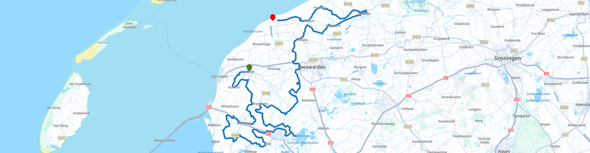
 Los franceses tienen el Mediterráneo, los frisones tienen su Middelzee. O más bien: hads. Porque el Middelzee ahora está completo. Y alrededor de ese antiguo mar interior hay maravillosos caminos sinuosos sobre diques.
En la casa Eisinga, los engranajes centenarios siguen funcionando en el ático. Es apretado y bajo allí. Si quieres subir y bajar los escalones empinados, tienes que fijarte bien dónde pones las botas de moto en los escalones estrechos. Y luego te golpeas la cabeza contra las luces bajas. Estrellas frente a los ojos, planetas en el techo. En la sala de estar bellamente pintada, los planetas giran imperturbables sobre la cama de caja, como lo hicieron hace siglos.
Después de Leiden, la ciudad de Franeker tenía la universidad más antigua de los Países Bajos. La Academia Franeker floreció desde 1585 hasta 1811, cuando el francés Napoleón cerró el instituto de ciencias. Uno de los estudiantes era Eise Eisinga. El hombre que conocemos del planetario en funcionamiento más antiguo del mundo.
Junto con su padre y su hermano, Eise construyó este milagro en su casa entre 1774 y 1781, para tranquilizar a sus contemporáneos. Pensaron que la tierra perecería porque varios planetas llegaron a estar en la constelación equivocada. Eise quería demostrar con su planetario que las cosas no irían tan rápido.
Unos kilómetros después de Franeker, la ruta hace una curva sobre el canal Van Harinxma. Una hermosa carretera de motor le espera allí. Die Slachtedijk es una obra maestra de la ingeniería vial. Aunque no estaba destinado a serlo. Gradualmente, desde el siglo XIII, varios diques sueltos se fusionaron en la estructura por la que pasarás. Donde pasas por las curvas con una vista de vastos prados a una altura agradable, el agua del Middelzee una vez se derramó.
En Bolsward, los frisones tienen un ayuntamiento que puede venderse fácilmente como palacio en Francia. Después de haber construido con caña y madera durante siglos, los frisones compensaron con creces el daño dejándonos hermosos edificios de piedra. El periodista de viajes romano Plinio despreció a los frisones en sus montículos, "náufragos en marea alta, marineros en marea baja". Pero ahora esos europeos del sur alrededor de su Mediterráneo amenazan con todo tipo de desastres, causados no por los planetas sino por nuestros propios humanos jugando con el clima.
Entonces eres mucho más agradable en Frisian Middelzee. Por el momento sin sequías extremas, calor u otro mal tiempo climático. Y Friesland, que representa libertad y felicidad. Por el momento, también puede conducir por aquí en los caminos del dique, tengamos cuidado con eso. Las losas de hormigón están tejidas en un hermoso patrón curvo.
Al este de Sneek, gira hacia Sneekermeer. Los barcos de recreo se balancean en el puerto de De Potten, los barcos de trabajo y los veleros antiguos pisan fuerte en columna a través del canal en el lago. Se sigue libremente el curso del Zwette (Swette, escriben los frisones), tradicionalmente la separación entre las islas de Oostergo y Westergo, regiones a ambos lados del Middelzee. Esta zanja fronteriza fue excavada alrededor de 1300 en el eje de la antigua Middelzee.
Donde había agua, había tierra. Y luego vinieron caminos de diques, que sobresalen por encima de la tierra. La ruta serpentea sobre una variedad de caminos de terraplén estrechos. ¡Kedung! ¡Kedoeng! los neumáticos hacen rítmicamente sobre las losas de hormigón con las que se cubre la carretera, Oye, ahí está de nuevo el Slachtedijk, con sus guirnaldas de fiesta.
Un 'ir' es una isla. Solías tener un Westergo y un Oostergo en Friesland, y el Middelzee estaba, sin sorpresa, justo en el medio. Westergo estaba bordeado por el mar de Wadden y el actual IJsselmeer, Oostergo corría hasta Lauwerszee. Las fronteras del sur de ambas islas consistían en turberas impenetrables, que se estaban recuperando de forma lenta pero segura.
Las marismas crecieron en la cuenca de Westergo, y se formó un amplio estuario en la frontera con Oostergo, que se llamó Bordine en el siglo VIII y más tarde Middelzee, cuando ya había sido reclamado. La capital de Frisia, Leeuwarden, yacía una vez sobre esas aguas. Pero la ciudad portuaria se convirtió en una ciudad rural a finales de la Edad Media, cuando el estrecho embudo, que aquí formaba el Mar Medio, se diqueó entre Westergo y Oostergo, se colmó de sedimentos y se rellenó.
Las iglesias de Frisia a veces tienen una característica especial. Si un pueblo no tenía suficiente dinero para una torre de iglesia real, la campana se colgaba en una construcción de madera, separada de la iglesia. Un campanario. El reloj servía para dar la hora a las personas que trabajaban en el campo. También se tocaba la campana en los peligros, en los funerales y en las bodas. Desde la época precristiana también se adoptó la función del reloj para ahuyentar al ejército de espíritus malignos, con los que se pensaba poblaban los campos, bosques y aguas.
'Mira', le dice un motociclista a otro en la pequeña iglesia de Hartwerd. Allí hay un sillón frisón. 'No', dice una señora, paseando a su perro. "¡Es un campanario!" Aprendí algo de nuevo.
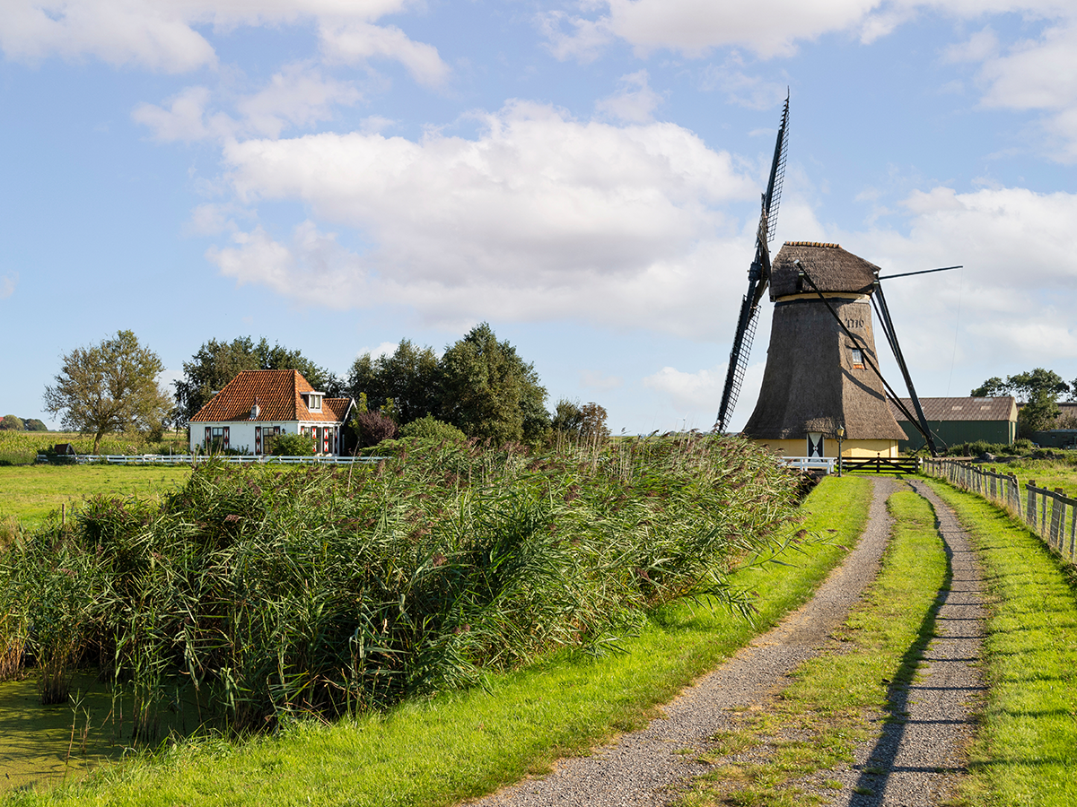
El molino de viento más alto de Frisia se encuentra en Burdaard, en un callejón sin salida junto al agua. A 36 metros de altura se encuentran los molinos de maíz, pelado y aserradero De Zwaluw. Hermoso mecanismo poderoso, casi todo hecho de madera, convierte la energía del viento en trabajo. Tablones de madera, harina de pan: tú pides, nosotros molemos.
Un guía voluntario nos precede. ¿Presta atención a sus pies y su cabeza? Puede subir las empinadas escaleras hasta el cuarto ático, donde tiene una hermosa vista de la plataforma sobre los barcos en Dokkumer Ee y las tierras circundantes.
Burdaard tiene otra atracción, no lejos del molino. El lechero Ruurd Wiersma condujo su motocicleta hacia su niña, pero a los señores de la iglesia, a los granjeros y al director de la lechería no les gustó eso. También conocemos a Ruurd porque pintó todo el interior de su casa, incluyendo la estufa y el techo, con escenas bíblicas en colores frescos e ingenuos. Así que no era tan pagano, ese Ruurd. Pero encaja muy bien en la imagen de libertad y felicidad de Frisia.
Dokkum, conocido como el punto más oriental de Frisian Elfstedentocht, es un pueblo con atractivos urbanos. Conduces a través de una hermosa ciudad rodeada de murallas y, por supuesto, hay barcos amarrados allí. Toda ciudad frisia que se precie tiene un puerto.
Frente a los diques, los montículos brindaban protección contra el agua del Middelzee. Estos cerros fueron levantados por mano humana. Cuando la tierra fue terraplenada, se excavaron muchos montículos debido al montículo fértil. Pero si había una iglesia en él, el montículo se salvó. Como en Hegebeintum. Después del molino más alto, ahora se encuentra el montículo más alto de Friesland. La mayoría de los montículos tenían entre dos y siete metros de altura, pero la joroba de Hegebeintum se yergue orgullosamente nueve metros por encima de NAP.
En el centro de visitantes puedes conseguir una taza de café y un guía-voluntario, que te mostrará el terp y la iglesia. La parte más antigua de la casa de culto está hecha de toba, que fue traída aquí desde Eifel en el siglo XII. Los monjes en Friesland aprendieron más tarde a hacer ladrillos, hay suficiente arcilla aquí, por lo que las últimas partes de la iglesia se hicieron con ella, incluida la torre. También contiene una campana para tocar y un reloj al que hay que darle cuerda a mano todos los días. Otro buen ejemplo de la mecánica frisona, no de Franeker esta vez, sino de Leeuwarden.
Los diques se construyeron sistemáticamente en Oostergo desde el siglo XI en adelante. El curso del dique más antiguo es la carretera actual de Holwerd vía Ferwert a Stiens. Hay algunas curvas agradables allí. Pero después de Oudebildtzijl se acabó. Un camino de dique recto se encuentra frente a nuestras ruedas.
Lo que acabas de mirar desde Hegebeintum, ahora conduces. Paralelo al malecón actual. El antiguo Middelzee se recuperó gradualmente de la Edad Media. Het Bildt se creó en 1505 con la construcción del Oudebildtdijk. Se llama la calle habitada más larga de Europa. Seguro que es largo. Y correcto Las guirnaldas de Slachtedijk son difíciles de encontrar aquí.
El Bildt fue la última parte del antiguo Middelzee en ser recuperada. Está diseñado con la regla, que se puede ver claramente en el mapa y mientras se conduce. Detrás de las casas hay tierra recién construida con diques, fértil incluso sin un montículo, detrás de ella el dique marino que se supone debe mantener fuera el agua del mar. Después de Nieuwebildtzijl, incluso puede conducir en el dique, tómelo con calma, debido a las ovejas en el camino.
En el Zwarte Haan te encontrarás con la estatua del Slikwerker, un homenaje a los trabajadores que ganaron la tierra al mar con la pala. Después de Westhoek, la carretera secundaria continúa de forma estrecha sobre el antiguo cuerpo del dique. Luego, el giro del Slachtedijk comienza de nuevo a la izquierda. Quien vuelve a entrar en el interior de Frisia, donde todo el juego de la libertad y la felicidad puede comenzar de nuevo. Un móvil perpetuo con el que Eise Eisinga solo podía soñar.
Slachte es una palabra antigua para dique interior. El Slachtedijk formó la frontera occidental del Middelzee. El dique de un metro y medio de altura serpentea unos 42 kilómetros desde la costa frisona de Wadden a través del paisaje frisón.
Los primeros diques se construyeron hace más de mil años y se remacharon durante siglos. De Slachte no es accesible para motocicletas en toda su longitud, por lo que aquí y allá hay que recurrir a alternativas. También recorren el verde Greidhoek, los jugosos prados donde el famoso ganado de pedigrí frisón proporciona acentos en blanco y negro.
Entre el cielo azul y la hierba verde hay hermosos pueblos aquí y allá, como el elegante Mantgum, Wiuwert (conocido por las momias en la iglesia) o Jorwert (conocido por el libro 'Cómo Dios desapareció de Jorwert' de Geert Mak) .


 Enlaces
  Uso
Uso ¿Quiere descargar esta ruta?
Puede descargar la ruta gratis sin la cuenta de MyRoute-app. Para hacerlo, abra la ruta y haga clic en 'guardar como'. ¿Quiere editar esta ruta?
No hay problema, comience abriendo la ruta. Siga el tutorial y cree su cuenta personal de MyRoute-app. Después de registrarse, su prueba comienza automáticamente.  Descargo de responsabilidad
El uso de esta ruta GPS es por su cuenta y riesgo. La ruta ha sido cuidadosamente compuesta y verificada por un RouteXpert acreditado por MyRoute-app para su uso en TomTom, Garmin y MyRoute-app Navigation.
No obstante, es posible que se hayan producido cambios debido a circunstancias cambiantes, desvíos de carreteras o cierres estacionales. Por lo tanto, recomendamos comprobar cada ruta antes de utilizarla.
Utilice preferentemente el track de ruta en su sistema de navegación. Más información sobre el el uso de la aplicación MyRoute se puede encontrar en el sitio web en 'Comunidad' o 'Academia'.
Provincia de Frisia
Acerca de esta región
Frisia (nombre oficial, en frisón: Fryslân [ˈfrislɔ̃ːn] ; en neerlandés, Friesland [ˈfris.lɑnt] ) es una de las doce provincias que conforman el Reino de los Países Bajos. Ocupa la parte occidental de la región histórica de Frisia.[2] La capital es Leeuwarden (en frisón, Ljouwert). Limita con las provincias de Groninga, Drente, Overijssel y Flevoland y con el mar de Frisia. Forman parte de esta provincia las islas de Vlieland, Terschelling, Ameland y Schiermonnikoog, que limitan con el mar del Norte.
Al igual que las demás provincias, está gobernada por un comisario designado por el monarca y una cámara legislativa elegida mediante sufragio universal. Las lenguas oficiales son el neerlandés y el frisón. Sin embargo, algunos frisones hablan dialectos del bajo sajón.
Leer más en Wikipedia
Al igual que las demás provincias, está gobernada por un comisario designado por el monarca y una cámara legislativa elegida mediante sufragio universal. Las lenguas oficiales son el neerlandés y el frisón. Sin embargo, algunos frisones hablan dialectos del bajo sajón.
Ver región
 Estadísticas
  49
49Cantidad de revisiones de RX (Provincia de Frisia)
 58670
58670Cantidad de visitantes (Provincia de Frisia)
 8203
8203Cantidad de descargas (Provincia de Frisia)
 Ruta de colecciones en esta región
 Las 10 rutas en coche y moto más bonitas de los Países Bajos
Estas 10 rutas en los Países Bajos han sido cuidadosamente seleccionadas, verificadas e igualadas para TomTom, Garmin y MyRoute-app Navigation por un MyRoute-app RouteXpert. Las 10 rutas de motocicletas y automóviles más hermosas de los Países Bajos son siempre una instantánea y una opinión personal del crítico. Esto no altera el hecho de que todos los amantes de las carreteras hermosas y los lugares interesantes disfrutarán de estas rutas.
Las diez rutas se distribuyen en 10 provincias, solo nos saltamos Flevoland y Holanda Meridional. También se pueden encontrar rutas interesantes en la biblioteca RouteXpert de la aplicación MyRoute, pero aún queremos ceñirnos a las 10 más hermosas y no a las 12 más hermosas.
Disfrute de las numerosas fortalezas y castillos que se incluyen en las rutas, como Fort Veldhuis en Holanda del Norte. Pero también eche un vistazo a la ruta al sureste de Nijmegen y visite el impresionante cementerio y monumento de guerra canadiense. La ruta 'Overijssel a vista de pájaro' incluye la casa más antigua de los Países Bajos y la ruta a lo largo del IJssel es probablemente la pieza de asfalto más hermosa de los Países Bajos.
De esta manera hay algo para todos en esta colección de rutas. Si no está de acuerdo con estas 10 rutas, envíenos un correo electrónico, indique qué ruta (s) deben eliminarse y qué ruta le gustaría ver en su lugar. ¡Quizás tu ruta esté incluida en esta colección de las 10 rutas más hermosas de los Países Bajos!
Correo electrónico: info@myrouteapp.com
Ver colección de rutas
Las 10 rutas en coche y en moto más bonitas de Frisia
Frisia oficialmente, frisón: Fryslân es una provincia del norte de los Países Bajos. Frisia tenía 660.560 habitantes en 2018. La capital es Leeuwarden. Además del holandés, el frisón tiene el estatus de lengua administrativa en la provincia. Pero, ¿quién no conoce Frisia del Elfstedentocht? Un festival de patinaje sin igual, desafortunadamente ha pasado mucho tiempo desde que la última gira de Elfsteden se llevó a cabo en Frisia, el 4 de enero de 1997 para ser precisos.
No solo tu propio idioma y un recorrido en patinaje por las 11 ciudades de Frisia, sino también una provincia muy bonita para recorrer en coche o moto y disfrutar de toda la belleza que la provincia de Frisia tiene para ofrecer. Para este propósito, una aplicación de MyRoute, RouteXpert, ha reunido un Top 10 de rutas para automóviles y motocicletas para usted.
Todas las rutas de esta colección se han verificado y se han igualado para TomTom, Garmin y MyRoute-app Navigation mediante una MyRoute-app RouteXpert.
Si crees que tengo una ruta muy bonita que ciertamente no debería faltar en esta colección, envíalo a:
correo electrónico: routeexpert@myrouteapp.com
Asunto: Nueva ruta para la colección Top 10 de la provincia de Frisia compilada por Hans van de Ven.
Luego, la ruta se revisará y luego se agregará al Top 10.
Para hacer del Top 10 también el Top 10, 1 ruta tendrá que desaparecer del Top 10, puede indicar esto al enviar la nueva ruta.
Diviértete con esta colección y mientras conduces por una de estas rutas. Disfrute de toda la belleza que ofrecen los Países Bajos y, en particular, la provincia de Frisia. Haga clic en "Ver ruta" para leer la reseña de la ruta elegida.
Me gustaría escuchar sus hallazgos sobre la (s) ruta (s).
Ver colección de rutas