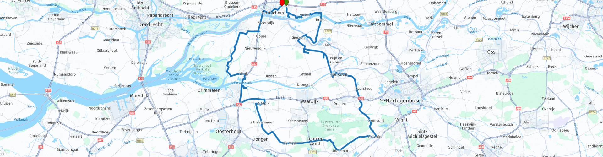
Roundtrip Brabant Gorinchem Heusden Loon op Zand Biesbosch Gorinchem

Questo percorso è stato creato da:
RouteXpert Johan Starrenburg
Ultima modifica: 11-07-2021
 Riepilogo percorso
  Condividi questo percorso


Animation

Verdetto


Durata
2h 54m

Modalità di viaggio
Auto o moto

Distanza
111.50 km

Paesi

 Revisione RouteXpert
 Iniziamo e fermiamo questo percorso alla stazione di servizio. Lasciamo presto questa provincia e passiamo per Fort Vuren, che fa parte della New Dutch Water Line, e che si trova nel comune di Lingewaal nella provincia di Gheldria.
Il forte fu costruito sul Waaldijk nel 1844 e servì a proteggere Gorinchem e impedire al nemico di spostarsi a ovest. Nel 1847-1849 fu costruita una torre a prova di bomba sulla cima del forte. Intorno alla torre fu scavato un fossato, dopo di che poteva essere raggiunto solo attraverso un ponte levatoio. La torre a prova di bomba fu in parte demolita nel 1873-1879 perché troppo fragile. L'ultimo piano è stato rimosso e è stata aggiunta la galleria di check-car. Il forte della torre, la galleria delle contro-macchine e la caserma ospitavano un massimo di 420 persone e 30 cannoni di artiglieria.
Dopo questo entriamo nel traghetto attraverso il Waal e dopo la traversata arriviamo nel Brabante.
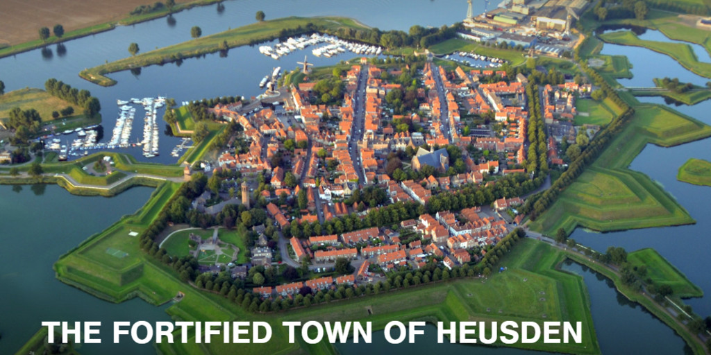
Il Vismark di Heusden è un bel posto per bere un caffè.
Dopodiché è davvero il momento di fare alcuni metri e guidiamo su diversi tipi di strade attraverso il Brabante Settentrionale verso il Biesbosch.
Il Biesbosch o Biesbos è il nome di una regione molto ricca di acqua nei Paesi Bassi. Consiste in una serie di isole fluviali e pianure di sabbia e fango nelle province olandesi di Noord-Brabant e Zuid-Holland, situate tra i fiumi Boven-Merwede e Amer e intersecate dal fiume artificiale Nieuwe Merwede (Wikipedia (NL)
Qui l'asfalto è bellissimo e le strade sono molto chiare.
Dopo il Biesbosch torniamo indietro attraverso la A27 e il ponte Merwede fino al punto di partenza del percorso.
La valutazione di 4 stelle si basa sul fatto che le strade sono buone e vale la pena vedere lo scenario e le attrazioni.

 Collegamenti
  Utilizzo
 Vuoi scaricare questo percorso?
Puoi scaricare il percorso gratuitamente senza un account MyRoute-app. Per farlo, apri il percorso e fai clic su 'Salva con nome'. Vuoi modificare questa rotta?
Nessun problema, inizia aprendo il percorso. Segui il tutorial e crea il tuo account MyRoute-app personale. Dopo la registrazione, la tua prova inizia automaticamente.  Disclaimer
L'utilizzo di questo percorso GPS è a tue spese e rischio. Il percorso è stato accuratamente composto e controllato da un RouteXpert accreditato dall'app MyRoute per l'utilizzo su TomTom, Garmin e navigazione dell'app MyRoute.
Ciononostante potrebbero essersi verificati cambiamenti a causa di mutate circostanze, deviazioni stradali o chiusure stagionali. Si consiglia pertanto di controllare ciascun percorso prima dell'uso.
Utilizzare preferibilmente la tracklog del percorso nel sistema di navigazione. Maggiori informazioni sul l'uso dell'app MyRoute può essere trovato sul sito Web in 'Community' o 'Academy'.