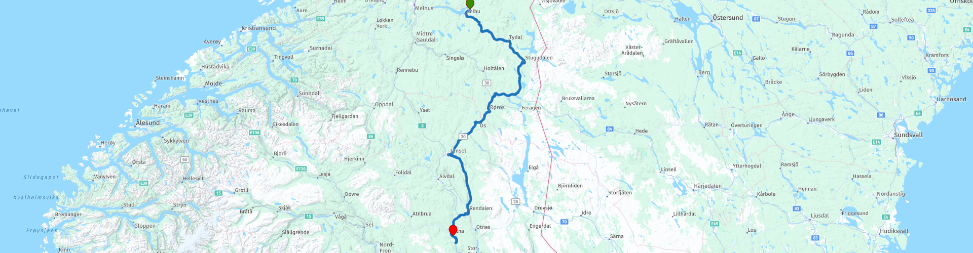
R08 Innbygda to Atna

Questo percorso è stato creato da:
RouteXpert Arno van Lochem - Senior RX
Ultima modifica: 04-10-2024
 Riepilogo percorso
 Questo percorso inizia alla reception del Selbu Camping, che è anche un supermercato e un distributore di benzina, situato a Innbygda.
Il punto finale di questo percorso è nei pressi di Atna, presso l'Atna Camping, situato sul fiume Glomma, il fiume più lungo della Norvegia. Il Camping Atna è un campeggio non troppo grande dove ci sono soprattutto roulotte, hanno qualche piazzola e un prato dove si può piazzare una tenda o un camper. Ci sono diversi campeggi nella zona, anche se un po' distanti.
Lungo la strada attraverserai numerosi fiumi, grandi laghi e The Big Elk, un alce alto oltre 10 metri.
I percorsi sono facili per tutti e si snodano (in gran parte) su strade ben asfaltate. Questo percorso contiene circa 6 chilometri di ghiaia, la condizione delle strade è tale che è facile per tutti.
Date le eccellenti condizioni delle strade, i bellissimi panorami e gli splendidi dintorni montuosi e rocciosi, valuto questo percorso con 5 stelle.
Numerosi traghetti vengono utilizzati su queste rotte attraverso la Norvegia. Semplificati le cose e usa FerryPay. La maggior parte dei traghetti norvegesi sono affiliati a questo, il pagamento è completamente automatico dopo aver scansionato la targa. Maggiori informazioni possono essere trovate nel collegamento in fondo a questa pagina.
 Condividi questo percorso


Animation

Verdetto


Durata
7h 0m

Modalità di viaggio
Auto o moto

Distanza
295.21 km

Paesi

 Revisione RouteXpert
 Dai fiumi tortuosi ai laghi aperti, dai sentieri di ghiaia che mettono alla prova la tua presa sulla strada alle attrazioni culturali come The Big Elk: questo percorso ha tutto. Usciamo insieme e vediamo cosa ti aspetta!
Questo itinerario in moto da Innbygda ad Atna ti porta attraverso alcune delle regioni più belle e remote della Norvegia. Lungo il percorso attraverserai bellissimi laghi come Selbusjøen e Aursunden, mentre i fiumi Nea e Tya ti accompagneranno durante la prima parte del giro. Non solo affronterai l'asfalto, ma sentirai anche impegnative strade sterrate che scivolano sotto le tue ruote: l'ideale per l'avventuriero nel cuore.
Anche il fiume Glomma, il fiume più lungo della Norvegia, ti viene incontro e ti avvicina alla bellezza naturale di questo paese. E se sei un fan dei luoghi più importanti, non dimenticare di fare una sosta a "The Big Elk", una gigantesca statua di un alce che ti farà sicuramente sorridere.
Il tranquillo villaggio di Innbygda è il luogo perfetto per iniziare la tua avventura in moto. Circondato da montagne e foreste, Innbygda offre un mix ideale di bellezza naturale e tranquillità. Prima di partire, immergiti nell'atmosfera locale e preparati per il viaggio.
La prima attrazione principale del percorso è Selbusjøen, un bellissimo lago che riflette il paesaggio circostante come uno specchio. Questo lago è uno dei più grandi laghi interni della Norvegia e offre panorami mozzafiato lungo il percorso. Scoprirai che l'aria fresca e la calma dell'acqua ti metteranno immediatamente nell'umore giusto per il resto della corsa.
Durante la prima parte del tuo viaggio segui il corso del fiume Nea, che ti porta attraverso valli ondulate e foreste. È il modo perfetto per lasciare libera la tua moto sulle strade tortuose. Successivamente il vostro percorso attraversa il fiume Tya, un ruscello un po' più piccolo ma certamente non per questo meno bello. Le dolci correnti di questi fiumi creano un piacevole contrasto con le strade più impegnative che vi aspettano più avanti.
Per coloro che amano le sfide, questo percorso offre anche alcune spettacolari strade sterrate. Qui le tue abilità di guida saranno davvero messe alla prova, perché la superficie è più ruvida e richiede maggiore concentrazione e controllo. Queste strade sterrate non solo ti danno una scarica di adrenalina, ma ti portano anche attraverso le parti più remote e incontaminate della regione. Qui ti senti davvero solo al mondo, circondato dalla pura natura selvaggia norvegese.
Non preoccuparti, queste strade sono perfette anche per gli automobilisti meno avventurosi!
Il maestoso Lago Aursunden è uno degli specchi d'acqua più grandi del vostro percorso e offre un panorama mozzafiato. La vastità del lago e delle montagne circostanti forniscono un'immagine indimenticabile. Qui potrete fermarvi un attimo per assorbire la tranquillità e magari scattare qualche foto che farà invidia ai vostri avventurosi amici motociclisti.
Quando raggiungi il fiume Glomma, guidi lungo il fiume più grande della Norvegia. Questo imponente corso d'acqua si snoda attraverso il paesaggio, aggiungendo un tocco di serenità al tuo viaggio. Lungo le rive del Glomma troverete spesso villaggi pittoreschi e vasti paesaggi che non fanno altro che aumentare la sensazione di libertà in viaggio.
Una delle fermate più suggestive del tuo percorso è senza dubbio The Big Elk, una gigantesca statua di un alce che si erge orgogliosamente lungo la strada. Quest'opera d'arte non è solo una statua, è un omaggio all'alce, animale che simboleggia la natura norvegese. Questa statua enorme e lucente è difficile da perdere e offre una piacevole pausa durante la corsa. È uno di quegli spettacoli divertenti a cui devi semplicemente fermarti e pensare, in senso letterale e figurato!
Alla fine, la tua avventura termina in un campeggio vicino alla tranquilla cittadina di Atna. Questo villaggio, che dovresti assolutamente visitare (anche solo per fare la spesa), è il luogo ideale per rilassarsi dopo una giornata all'insegna del piacere di guida e della natura. Qui potrete godervi una meritata pausa, un pasto locale o semplicemente una tranquilla passeggiata lungo il fiume. Atna è piccola ma affascinante e rappresenta il finale perfetto per un viaggio avventuroso.
Divertiti a percorrere questo percorso!


 Collegamenti
  Utilizzo
 Vuoi scaricare questo percorso?
Puoi scaricare il percorso gratuitamente senza un account MyRoute-app. Per farlo, apri il percorso e fai clic su 'Salva con nome'. Vuoi modificare questa rotta?
Nessun problema, inizia aprendo il percorso. Segui il tutorial e crea il tuo account MyRoute-app personale. Dopo la registrazione, la tua prova inizia automaticamente.  Disclaimer
L'utilizzo di questo percorso GPS è a tue spese e rischio. Il percorso è stato accuratamente composto e controllato da un RouteXpert accreditato dall'app MyRoute per l'utilizzo su TomTom, Garmin e navigazione dell'app MyRoute.
Ciononostante potrebbero essersi verificati cambiamenti a causa di mutate circostanze, deviazioni stradali o chiusure stagionali. Si consiglia pertanto di controllare ciascun percorso prima dell'uso.
Utilizzare preferibilmente la tracklog del percorso nel sistema di navigazione. Maggiori informazioni sul l'uso dell'app MyRoute può essere trovato sul sito Web in 'Community' o 'Academy'.

Trondelag
Informazioni su questa regione
Il Trøndelag (pronuncia norvegese: [²trønːdəˌlɑːɡ]) è una contea della Norvegia.
Il territorio coincide anche con la regione del Trøndelag ma le regioni costituiscono una suddivisione di rilevanza esclusivamente storico-geografica. La capitale è Trondheim, che fu la prima capitale stabile del regno norvegese. Nel 1804 venne suddivisa in due contee, Nord-Trøndelag (Trøndelag nord) e Sør-Trøndelag (Trøndelag sud), che sono state riunificate in un'unica contea a partire dal 1º gennaio 2018.
Leggi di più su Wikipedia
Il territorio coincide anche con la regione del Trøndelag ma le regioni costituiscono una suddivisione di rilevanza esclusivamente storico-geografica. La capitale è Trondheim, che fu la prima capitale stabile del regno norvegese. Nel 1804 venne suddivisa in due contee, Nord-Trøndelag (Trøndelag nord) e Sør-Trøndelag (Trøndelag sud), che sono state riunificate in un'unica contea a partire dal 1º gennaio 2018.
Visualizza regione
 Statistiche
  9
9Quantità di recensioni RX (Trondelag)
 16215
16215Quantità di visitatori (Trondelag)
 584
584Quantità di download (Trondelag)
 Indirizza le collezioni in questa regione
 In 12 giorni da Oslo a Capo Nord
Questa è una raccolta di percorsi di un tour in moto da Oslo a Capo Nord, basata su un viaggio di Thomas Falck Østli. Sono stati descritti un totale di dodici percorsi, ma il tour può essere esteso a più giorni, maggiori informazioni a riguardo nelle recensioni.
I percorsi attraversano gli splendidi paesaggi della Norvegia, comprese le Lofoten, con molti laghi, fiordi, fiumi, bellissimi ponti, bellissime foreste verdi e aspre montagne. Durante il viaggio ci sono anche molte traversate in traghetto, tienilo a mente nella tua pianificazione.
Percorri lunghe distanze in Norvegia senza incontrare una stazione di servizio o un ristorante, tienilo a mente prima di guidare. Assicurati che il tuo serbatoio sia pieno e porta cibo e bevande. Porta qualche bottiglia d'acqua o una borsa Camel e riempila quando ti fermi per fare rifornimento. Lungo il percorso sono previste pause per fare rifornimento, mangiare e bere.
Il percorso totale di quasi 3700 chilometri è suddiviso come segue;
• Il giorno 1 è un viaggio di 434 chilometri da Oslo a Geiranger
• Il secondo giorno è un viaggio di 238 chilometri da Geiranger a Kristiansund
• Il giorno 3 è un viaggio di 298 chilometri da Kristiansund via Trondheim a Verdal
• Il giorno 4 è un viaggio di 333 chilometri da Verdal a Brønnøysund
• Il 5 ° giorno è un viaggio di 267 chilometri da Brønnøysund a Furøy
• Il giorno 6 è un viaggio di 296 chilometri da Furøy Lofoten a Reine
• Il 7 ° giorno è un viaggio di 218 chilometri da Reine a Ørsvågvær
• Il giorno 8 è un viaggio di 274 chilometri da Ørsvågvær a Straumsjøen
• Il giorno 9 è un viaggio di 327 chilometri da Straumsjøen a Senjahopen
• Il giorno 10 è un viaggio di 321 chilometri da Senjahopen a Tromsø
• Il giorno 11 è un viaggio di 420 chilometri da Tromsø ad Alta
• Il giorno 12 è un viaggio di 239 km da Alta attraverso Capo Nord a Skarsvåg
Hai la possibilità di pernottare in campeggio o in hotel. I prezzi degli hotel in Norvegia non sono particolarmente alti e la colazione è solitamente inclusa.
Il campeggio è gratuito quasi ovunque, tranne che su proprietà private o dove il campeggio è vietato, segnalato da cartelli di divieto.
Se non vuoi campeggiare, ci sono spesso cabine in affitto nei campeggi. Per un viaggio in Norvegia è sempre consigliabile portare una tenda e altra attrezzatura da campeggio.
Le informazioni su hotel e campeggi sono incluse nelle indicazioni
Divertiti a leggere, pianificare e guidare questo viaggio panoramico verso la punta più settentrionale d'Europa.
Visualizza raccolta percorsi
6500 chilometri attraverso la Scandinavia con i punti salienti delle Lofoten e di Capo Nord
L'Arctic Challenge Tour, su cui si basa in parte questo tour in 26 parti, non è una gara di velocità. È un tour. Si tratta di agilità, buona navigazione e anticipazione. I partecipanti sono obbligati a rispettare il limite di velocità del paese interessato. I partecipanti devono trovare il percorso ideale con la distanza più breve possibile rispettando al 100% le regole del traffico applicabili a livello locale. Ovviamente, tieni conto anche delle velocità massime. L'organizzazione verifica le violazioni del limite di velocità. In caso di superamento grossolano o ripetuto della velocità massima, seguirà la squalifica per la relativa tappa e per la classifica finale. Il controllo del percorso e della velocità avviene tramite un sistema track and trace. Questa attrezzatura è installata in ogni veicolo. Potrai quindi seguire accuratamente ogni squadra nel Back Office. Chi resta a casa, gli interessati ei partecipanti possono anche vedere le esibizioni delle squadre, perché si può essere seguiti in diretta via Internet. Il Back Office interviene quando un team si trova nei guai. (fonte: sito web The Arctic Challenge)
È un bel lusso, avere un back office dietro di te che ti tiene d'occhio. La maggior parte di noi non lo avrà e sarà da solo o con i compagni di viaggio. L'unico accordo che hai con i partecipanti è che devi anche rispettare le regole. Fortunatamente, non devi completare questo tour in 9 giorni, come i partecipanti, ma puoi impiegare un po' più di tempo.
Il momento clou dell'Arctic Challenge nel 2020 sono state le Lofoten, un gruppo di isole a nord-ovest della Norvegia. L'arcipelago delle Lofoten si trova nel mezzo del selvaggio Mare di Norvegia, ben al di sopra del Circolo Polare Artico. Questa regione speciale offre un bellissimo paesaggio con montagne imponenti, profondi fiordi e lunghe spiagge sabbiose selvagge dove si può sempre sentire il suono delle colonie di uccelli marini.
L'arcipelago è meglio conosciuto per la sua ricca tradizione di pesca. Le Lofoten fanno un'impressione prospera nonostante la loro posizione isolata. L'intera economia ruota soprattutto intorno alla pesca. L'immagine delle Lofoten è principalmente dominata da rastrelliere in legno con merluzzo, che pende ad asciugare. La pesca alle Lofoten è un nome familiare da secoli. In pieno inverno, le navi partirono per catturare il pesce in pochi mesi. Le ricche zone di pesca sono dovute alla corrente calda del Golfo del Nord Atlantico intorno alle isole, in cui i pesci hanno le loro zone di riproduzione. La trivellazione petrolifera non è consentita intorno alle Lofoten e alle zone di riproduzione del merluzzo.
La prossima destinazione per i partecipanti è stata Sirkka, conosciuta anche come Levi, una località di sport invernali nella Lapponia finlandese. Rimasero lì alcuni giorni per andare in kart e godersi la neve in motoslitta o in gita sugli sci. Questo tour ti porta anche a Sirkka, ma invece di fermarti per qualche giorno, hai la possibilità di proseguire per Capo Nord, il secondo momento clou di questo viaggio.
Immagina un luogo nell'estremo nord, dove l'Oceano Atlantico incontra le acque gelide dell'Oceano Artico. Questo posto è Capo Nord nel Finnmark occidentale nella Norvegia settentrionale. Da qui, solo l'arcipelago di Spitsbergen si trova tra te e il Polo Nord e il sole splende per 2,5 mesi alla volta; da metà maggio a fine luglio. Molti visitatori ammirano il sole di mezzanotte o il tramonto sul Mare di Barents dall'altopiano di Capo Nord.
Con ogni percorso troverai una recensione con una descrizione del percorso, dove passi e cosa vedere lungo il percorso. Viene anche brevemente descritto come i partecipanti all'Arctic Challenge nel 2020 hanno dovuto guidarla comunque, da quale punto a quale punto. Lungo il percorso sono stati inseriti dei contrassegni (punti di percorso) che indicano i punti finali delle tappe che i partecipanti dovevano completare. Come accennato, hanno coperto la distanza in 9 giorni, tappe di oltre 1000 chilometri non hanno fatto eccezione.
Ogni percorso termina in un hotel. Ovviamente non è un obbligo usare questi hotel, puoi sempre trovare un altro posto dove stare in zona, quella decisione spetta a te. La mia esperienza, tuttavia, è che sono tutti hotel semplici ma buoni a un prezzo molto ragionevole. Sono noti e possono essere prenotati su booking.com.
I percorsi di queste collezioni:
R01 - Puttgarden a Angelholm, 280 km
R02 - Da Angelholm ad Alingsas, 281 km
R03 - Da Alingsas a Mysen, 261 km
R04 - Da Mysen a Rena, 312 km
R05 - Da Rena a Orkanger, 306 km
R06 - Da Orkanger a Grong, 292 km
R07 - Da Grong a Mo i Rana, 290 km
R08 - Da Mo i Rana a Bodo, 231 km
R09 - Giro da Bodo a Lofoten parte 1, 314 km
R10 - Giro da Bodo a Lofoten parte 2, 250 km
R11 - Giro da Bodo a Lofoten parte 3, 291 km
R12 - Da Bodo ad Arjeplog, 295 km
R13 - Da Arjeplog a Jokkmokk, 244 km
R14 - Da Jokkmokk a Pajala, 239 km
R15 - Giro da Sirkka a Capo Nord parte 1, 257 km
R16 - Giro da Sirkka a Capo Nord parte 2, 300 km
R17 - Giro da Sirkka a Capo Nord parte 3, 244 km
R18 - Giro da Sirkka a Capo Nord parte 4, 275 km
R19 - Giro da Sirkka a Capo Nord parte 5, 332 km
R20 - Da Sirkka a Kemi, 299 km
R21 - Da Kemi a Ylivieska, 251 km
R22 - Da Ylivieska a Jalasjarvi, 236 km
R23 - Da Jalasjarvi a Turku, 279 km
R24 - Da Stoccolma a Askersund, 271 km
R25 - Askersund a Varnamo, 224
R26 - Da Varnamo a Trelleborg, 259 km
Divertiti a guidare questi percorsi!
Visualizza raccolta percorsi