Denver Aspen Three Day Round Trip

Questo percorso è stato creato da:
RouteXpert René Plücken (MRA Master)
Ultima modifica: 20-08-2025
 Riepilogo percorso
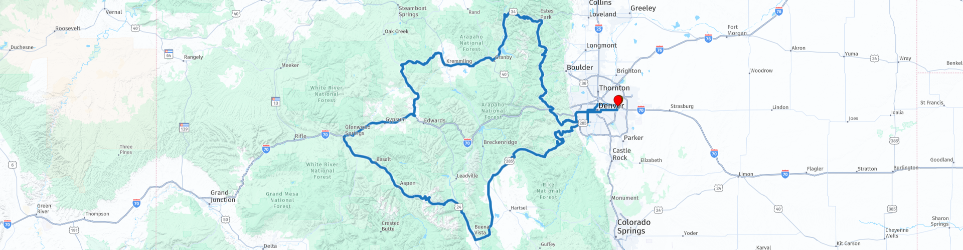
 È un insieme di diverse strade secondarie, interstatali e autostrade panoramiche. Tantissime cose da vedere e da fare.
Visiterete siti storici e sportivi. Attraverserete splendidi passi montani e valli incantevoli, costeggiando laghi e fiumi impetuosi.
Ci sono diversi villaggi e città che puoi visitare, dove puoi mangiare, bere e sgranchirti le gambe.
Valuto questo tour con 5 stelle perché unisce tante strade meravigliose, paesaggi e attività interessanti.
 Condividi questo percorso


Animation

Verdetto


Durata
25h 0m

Modalità di viaggio
Auto o moto

Distanza
947.64 km

Paesi

 Revisione RouteXpert
 Si tratta di una combinazione di autostrade interstatali, superstrade e diverse strade panoramiche nel Colorado centro-settentrionale, come:
• Independence Pass (chiuso da ottobre a maggio)
• Strada panoramica delle sorgenti del fiume Colorado
• Strada di Trail Ridge
• Da picco a picco
• Anello Lariat
Il viaggio inizia a Denver, presso il Quality Inn Hotel, vicino all'aeroporto. Vicino all'hotel si trova una concessionaria Harley-Davidson che noleggia motociclette.
Le strade sono di buona qualità, ma possono essere fangose. I panorami lungo il percorso sono mozzafiato, si gode di una splendida vista sulle montagne innevate e si costeggiano diversi fiumi, come il Colorado, e splendidi laghi. Ammirerete una natura incontaminata e ci saranno delle soste interessanti, alcune delle quali sono indicate nella recensione e contrassegnate da un waypoint.
Il viaggio è lungo 950 km in totale ed è previsto come un viaggio on the road di tre giorni con due pernottamenti in hotel. È possibile personalizzare l'itinerario in base alle proprie preferenze e prolungarlo ulteriormente; è anche possibile scegliere di pernottare in campeggio, dato che lungo il percorso sono presenti diverse strutture ricettive.
Alla fine del primo giorno o all'inizio del secondo, potrete scegliere di visitare AVA Rafting & Zipline, un'azienda leader nel settore delle avventure all'aria aperta che offre escursioni guidate di rafting sul fiume Colorado, oltre a zipline, arrampicata, pesca a mosca e molto altro. Cabine e campeggi sono disponibili in loco a un costo aggiuntivo, ed è anche possibile pernottare in hotel. Assicuratevi di avere abbastanza tempo a disposizione, poiché l'attività richiederà mezza giornata.
Tra Twin Lakes e Aspen attraverserete il famoso Independence Pass. Si tratta di un bellissimo passo di montagna con alcuni tornanti mozzafiato, a un'altitudine di 3.687 m. Prendetevi del tempo per una sosta ai punti panoramici, dove potrete ammirare il panorama e scattare qualche foto.
Fate una sosta a Ghost Town Independence, una città mineraria negli anni '80 del XIX secolo. A causa dei rigidi e lunghi inverni e della mancanza di opportunità minerarie, la città fu infine abbandonata, e molti cercarono migliori opportunità minerarie ad Aspen e altrove.
La prossima tappa è The Devils Punchbowl e le Grotte, un luogo popolare per i tuffi dalle scogliere. Si tratta di una grande formazione rocciosa dove l'acqua si accumula lungo il fiume Roaring Fork. Se siete abbastanza coraggiosi, potete tuffarvi o tuffarvi dalle scogliere nel Punchbowl. Il Grottos Trail è un sentiero di 1,1 km con una cascata ed è adatto a tutti i livelli. Il sentiero offre numerose attività.
Ci dirigiamo ad Aspen, dove ci fermiamo per sgranchirci le gambe, visitare la città e pranzare. Aspen è una cittadina piccola e affascinante, da anni una delle mete più ambite al mondo per gli sport invernali. È splendida anche in altre stagioni. In primavera, migliaia di fiori selvatici sbocciano, in estate si possono fare escursioni vicino alle splendide Maroon Bells e in autunno gli alberi colorano la zona di un giallo dorato. Aspen è davvero una meta per i turisti attivi. Oltre all'escursionismo, è possibile praticare mountain bike, kayak, rafting e arrampicata.
Dopo Aspen, il viaggio prosegue lungo il fiume Roaring Fork fino a Glenwood Springs, dove è possibile pianificare una breve sosta per un rinfresco e un rifornimento di carburante, se necessario. Glenwood Springs è ricca di storia e cultura e ospita una vivace offerta gastronomica, boutique, campi da golf panoramici e una lista infinita di attività all'aperto.
Da Glenwood Springs prendiamo l'Interstatale 70 fino a Wolcott. Sono circa 70 km attraverso paesaggi mozzafiato. Fate una breve sosta a Grizzly Creek, dove, se avete tempo, potrete fare una passeggiata. Grizzly Creek è uno dei tanti affluenti del fiume Colorado. Il sentiero di andata e ritorno si snoda lungo il torrente per diversi chilometri, tra spettacolari e imponenti scogliere. Sicuramente una delle migliori escursioni del Colorado, con aree picnic e numerosi punti panoramici sul fiume, la rendono una meta molto gettonata per le gite estive.
A Wolcott imbocchiamo la Colorado State Highway 131, un altro splendido percorso attraverso le montagne del Colorado, con belle curve e viste meravigliose.
Potete visitare il 4 Eagle Ranch, dove potrete dedicarvi a una varietà di attività all'aperto. Un'autentica esperienza in un ranch, ricca di divertenti attività per famiglie. Il complesso offre un mix unico di attività all'aperto come la teleferica, l'equitazione, tour in jeep 4x4 e quad, degustazioni di vini e molto altro. Il viaggio prosegue attraverso le Montagne Rocciose e la Medicine Bow-Routt National Forest fino a Kremmling, dove trascorreremo la notte.
L'ultimo giorno di questo viaggio su strada di tre giorni prosegue sulla Highway 40, il tratto di 26 km è anche chiamato Colorado River Headwaters Scenic Byway perché costeggia le rive del fiume Colorado offrendo viste fantastiche, quindi prevedete abbastanza tempo per fermarvi di tanto in tanto e godervi gli splendidi dintorni.
Il viaggio prosegue sulla Trail Ridge Road, un'altra strada panoramica, attraverso le Montagne Rocciose, con una sosta al Forest Canyon Overlook, da cui si può ammirare una splendida vista panoramica sulle Montagne Rocciose.
Potete fermarvi al Centro Visitatori di Beaver Meadows per guardare il breve filmato introduttivo. Sono disponibili anche informazioni sul parco e sulle attività interpretative, mappe e libri. L'ufficio prenotazioni centrale è accessibile tramite un sentiero che conduce a un piccolo edificio appena a est dell'ufficio principale.
Sulla via del ritorno percorriamo la panoramica Peak To Peak Highway, inaugurata nel 1918, la più antica Scenic Byway del Colorado. Pranziamo nella cittadina di Nederland. Originariamente Breed's Caribou Mill a Middle Boulder, divenne nota ai minatori come "Nederland", che significa "pianura" (e lo è, in confronto alla cittadina di Caribou, a 3.000 metri sul livello del mare). Nel 1874, quando la cittadina divenne comune, gli abitanti scelsero "Nederland" come nuovo nome.
Proseguiamo il nostro viaggio attraverso una splendida strada tortuosa fino a Black Hawk, una delle principali destinazioni del Colorado, con numerosi casinò, una dozzina di hotel e innumerevoli ristoranti.
La prossima tappa interessante per qualche foto, e se volete fare una breve passeggiata, è la Cleer Creek Greenway. Il percorso prosegue lungo un tratto della Lariat Loop Scenic & Historic Byway. Potete fare una breve sosta per scattare una foto all'Evergreen Lake. Potete fermarvi per cena alla fine della Lariat Loop a Morrison o proseguire il viaggio e programmare una cena in uno dei tanti ristoranti del centro di Denver, la nostra destinazione finale.


 Collegamenti
  Utilizzo
 Vuoi scaricare questo percorso?
Puoi scaricare il percorso gratuitamente senza un account MyRoute-app. Per farlo, apri il percorso e fai clic su 'Salva con nome'. Vuoi modificare questa rotta?
Nessun problema, inizia aprendo il percorso. Segui il tutorial e crea il tuo account MyRoute-app personale. Dopo la registrazione, la tua prova inizia automaticamente.  Disclaimer
L'utilizzo di questo percorso GPS è a tue spese e rischio. Il percorso è stato accuratamente composto e controllato da un RouteXpert accreditato dall'app MyRoute per l'utilizzo su TomTom, Garmin e navigazione dell'app MyRoute.
Ciononostante potrebbero essersi verificati cambiamenti a causa di mutate circostanze, deviazioni stradali o chiusure stagionali. Si consiglia pertanto di controllare ciascun percorso prima dell'uso.
Utilizzare preferibilmente la tracklog del percorso nel sistema di navigazione. Maggiori informazioni sul l'uso dell'app MyRoute può essere trovato sul sito Web in 'Community' o 'Academy'.
a.jpg/800px-Maroon_Bells_(11553)a.jpg)
Colorado
Informazioni su questa regione
Il Colorado (in inglese , [kɒləˈrædoʊ]) è uno Stato federato degli Stati Uniti d'America situato nella Regione delle Montagne Rocciose. Confina a nord con il Wyoming e il Nebraska, a sud con l'Oklahoma e il Nuovo Messico, a ovest con lo Utah, a est con il Kansas, in un solo punto tocca l'Arizona, nel suo angolo a sud-ovest (è il famoso punto del confine quadruplo che dà origine a quelli che gli statunitensi usano chiamare i Four corner states). È l'8º Stato degli USA per superficie e il 21° per popolazione.
Soprannominato Centennial State perché diventato uno Stato federato nel 1876, cento anni dopo la Dichiarazione d'indipendenza degli Stati Uniti, la capitale e città più popolosa è Denver, ed è uno dei due soli stati degli Stati Uniti d'America a essere un "rettangolo" perfetto (applicato sulla sfera planetaria e non con geometria euclidea, e per conseguenza con quattro confini rettilinei, per meridiani e paralleli; l'altro Stato è il Wyoming).
L'animale simbolo è il Bighorn, una specie di pecora nordamericana che deve il suo nome alle corna.
Leggi di più su Wikipedia
Soprannominato Centennial State perché diventato uno Stato federato nel 1876, cento anni dopo la Dichiarazione d'indipendenza degli Stati Uniti, la capitale e città più popolosa è Denver, ed è uno dei due soli stati degli Stati Uniti d'America a essere un "rettangolo" perfetto (applicato sulla sfera planetaria e non con geometria euclidea, e per conseguenza con quattro confini rettilinei, per meridiani e paralleli; l'altro Stato è il Wyoming).
L'animale simbolo è il Bighorn, una specie di pecora nordamericana che deve il suo nome alle corna.
Visualizza regione
 Statistiche
  20
20Quantità di recensioni RX (Colorado)
 19395
19395Quantità di visitatori (Colorado)
 347
347Quantità di download (Colorado)
 Indirizza le collezioni in questa regione
 Da costa a costa attraverso gli Stati Uniti
14 giorni negli Stati Uniti
Inizia il viaggio al molo di Daytona sulla costa atlantica.
Per 14 giorni visiterai New Orleans, Memphis, Tulsa, Colorado Springs, Las Vegas e Los Angeles. Ammira i monumenti di Monument e Death Valley, la diga di Hoover. Percorri 12 Stati Uniti per 4267 miglia di avventura prima di terminare il viaggio sul molo di Santa Monica, a Los Angeles, sulla costa del Pacifico
Visualizza raccolta percorsi
I 10 percorsi più scaricati negli Stati Uniti da RouteXpert Hans van de Ven
Ciao e benvenuto a questa raccolta delle 10 migliori rotte scaricate dall'app MyRoute negli Stati Uniti.
Presto sarà annunciato un nuovo grande evento, in cui tutti questi percorsi possono essere percorsi.
Scaricali tutti ora e inseriscili in una nuova cartella "Top 10", in modo da averli sempre a portata di mano.
Se intendi percorrere uno di questi percorsi nel frattempo, seguilo con l'app MRA Mobile o con la navigazione MRA. Scatta alcune foto (momenti) lungo il percorso in quanto ti torneranno utili.
Crea un diario di viaggio dei tuoi primi 10 percorsi guidati e aggiungi la traccia registrata.
Ci saranno anche alcuni fantastici premi in offerta, quindi tieni d'occhio la pagina MRA-RouteXperts e la tua posta.
I 10 percorsi sono:
1. D13 Estes Park Denver
2. D03 Chadron Custer
3. D01 Pigeon Forge andata e ritorno attraverso le Smokey Mountains
4. D08 Kalispell Sandpoint
5. D10 Colville Wenatchee
6. D09 Sandpoint Colville
7. D04 Custer Wall
8. D11 Wenatchee Seattle
9. D08 Cody Yellowstone NP
10.R13 San Francisco Monterey
Visualizza raccolta percorsi