Vorarlberg roundtrip 4 Rankweil to Schwaegalp and Appenzell

Cet itinéraire a été créé par:
RouteXpert Edgar Hofer
Dernière modification: 16-04-2023
 Résumé de l'itinéraire
 Il s'agit du 4ème itinéraire de ma collection de circuits circulaires du Vorarlberg.
Ce tour circulaire vous emmène en Suisse. Ce circuit fait le tour du Säntis, la plus haute montagne des Alpes d'Appenzell. Pour nous, Vorarlbergers, une visite populaire en Suisse voisine.
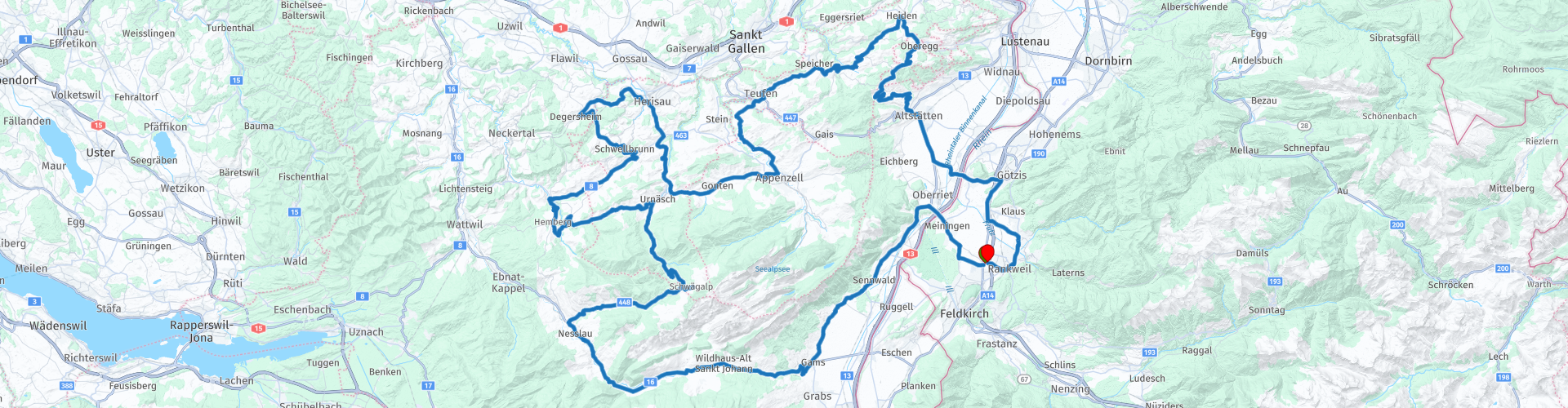
Départ et arrivée : Rankweil (atelier gastronomie)
Parcours : Rankweil - Wildhaus - St. Johann - Schwägalp - Urnäsch - Hemberg - Herisau - Appenzell - Trogen - Altstätten - Rankweil
L'itinéraire est identique pour l'application TomTom, Garmin et MyRoute.
Si vous conduisez cette visite, veuillez noter les informations suivantes :
● Une certaine expérience de la montagne est nécessaire
● Assurez-vous de surveiller votre vitesse en Suisse. Les excès de vitesse coûtent très cher en Suisse.
Je donne 5 étoiles à cette tournée. Il offre tout ce dont un grand tour à moto a besoin. De très beaux paysages, de belles vues et de très bonnes routes.
 Partager cet itinéraire


Animation

Verdict


Durée
6h 17m

Mode de déplacement
Voiture ou moto

Distance
195.27 km

Pays


 RouteXpert Review
 Après avoir commencé à Rankweil, ils traversent directement la frontière suisse. Dès la traversée du Rhin, vous remarquerez la trêve des ruines de Blatten.
Le château de Blatten est un château en ruine du canton de Saint-Gall. Le donjon carré se trouve non loin du Rhin sur un rocher au sud d'Oberriet. Le château a été construit vers 1230 par l'abbé de Saint-Gall Berchtold von Falkenstein pour se protéger des voisins puissants tels que les comtes de Montfort. Le château connut plusieurs propriétaires et fut détruit en 1799 lors de combats entre troupes autrichiennes et françaises. Les vestiges conservés sont constitués de parties de la tour et de l'anneau du château ainsi que de la cave voûtée.
Vous continuez au pied de l'Alpstein dans les Alpes d'Appenzell jusqu'à Gams. Après Gams, l'ascension vers Wildhaus commence. Après les dernières vues sur la vallée du Rhin, une route parfaitement aménagée serpente dans une petite vallée. Peu avant Wildhaus, la vallée s'élargit à nouveau et vous traversez le Toggenburg jusqu'à Nesslau.
Immédiatement après Nesslau, tournez à droite et roulez sur une route bien développée à travers l'un des plus beaux paysages d'Appenzell jusqu'à Schwägalp. Un horizon changeant vous accompagnera jusqu'à la première vue sur le Säntis. Malgré la toile de fond gênante, veuillez toujours contrôler votre vitesse. Sinon, un arrêt coûteux et imprévu pourrait en résulter.
Immédiatement après avoir traversé le col, tournez à droite à l'embranchement vers la station inférieure du train suspendu du Säntis. Même si le parking est déjà plein, vous pouvez conduire jusqu'au bout de la rue. Vous êtes dans un pays qui a toujours un cœur pour les motocyclistes, affectueusement appelés "conducteurs Töff" en Suisse. Au bout de la rue se trouve un parking dédié aux motards.
Vous êtes maintenant au pied du Säntis. Le Säntis (2502m) est la plus haute montagne de l'Alpstein. En raison de sa situation en amont, la montagne est un point de repère visible de loin. Six pays sont visibles depuis le sommet : la Suisse, l'Allemagne, l'Autriche, le Liechtenstein, la France et l'Italie. Même dans la Forêt-Noire, il y a des maisons portant le nom de Säntisblick.
Si vous souhaitez profiter de la vue depuis le Säntis ou boire votre café au restaurant du sommet, le train suspendu vous emmènera au sommet à intervalles réguliers. En 10 minutes plus de 1100 mètres d'altitude sont franchis.
Quelle que soit votre décision, un café avec un «croissant suisse» est définitivement à l'ordre du jour. La terrasse du Gasthaus Passhöhe est toujours mon premier choix. L'auberge, qui possède également son propre stationnement pour motos, est un lieu de rencontre populaire pour les conducteurs de cyclomoteurs de la région.
Après la pause, ils continuent vers Appenzellerland. Si votre cœur s'est déjà réchauffé pendant le voyage à Schwägalp, il va certainement devenir très chaud pour vous maintenant. L'Appenzellerland est un paysage vallonné caractérisé par des pâturages et des villages dispersés et est certainement l'une des plus belles régions de Suisse.
Même la descente vers Urnäsch offre tout ce qu'un motard peut souhaiter. Continuez en direction de Hemberg pour passer par Herisau jusqu'à la ville d'Appenzell. Les routes et les paysages vous impressionneront.
Sur des routes variées, vous atteignez le point de vue de St. Anton. De ce point de vue, vous pouvez voir toute la vallée du Rhin, le lac de Constance et le sud de l'Allemagne. Vous n'avez que l'embarras du choix pour faire une pause. Le belvédère offre trois options pour une pause café ou boisson.
Après la pause, la visite vous ramène dans la vallée du Rhin, à Altstätten. Encore quelques kilomètres et après avoir traversé le Rhin vous êtes de retour dans le Vorarlberg. Maintenant que votre estomac grogne, c'est l'heure d'un long déjeuner tardif dans le jardin d'hôtes du Gasthaus Adler à Sulz. N'ayez pas peur, ce n'est qu'à quelques mètres de votre point de départ.


 Liens
Liens  Utilisation
 Vous voulez télécharger cette route?
Vous pouvez télécharger l'itinéraire gratuitement sans compte MyRoute-app. Pour ce faire, ouvrez l'itinéraire et cliquez sur 'enregistrer sous'. Vous voulez éditer cette route?
Pas de problème, commencez par ouvrir la route. Suivez le tutoriel et créez votre compte personnel MyRoute-app. Après l'enregistrement, votre essai démarre automatiquement.  Avertissement
L'utilisation de cet itinéraire GPS est à vos propres frais et risques. L'itinéraire a été soigneusement composé et vérifié par un RouteXpert accrédité par MyRoute-app pour une utilisation sur TomTom, Garmin et MyRoute-app Navigation.
Des modifications peuvent néanmoins s'être produites en raison de circonstances modifiées, de déviations de routes ou de fermetures saisonnières. Nous vous recommandons donc de vérifier chaque itinéraire avant de l'utiliser.
Utilisez de préférence le tracé de l'itinéraire dans votre système de navigation. Plus d'informations sur le l'utilisation de MyRoute-app peut être trouvée sur le site Web sous 'Communauté' ou 'Académie'

Vorarlberg
À propos de cette région
Le Vorarlberg est le land le plus occidental de l'Autriche. Situé « devant l'Arlberg » (en allemand : vor dem Arlberg), sa superficie est de 2 601 km2 et sa population est de 395 012 habitants. Sa capitale est Brégence, sa plus grande ville est Dornbirn. Il est bordé à l'ouest par le canton suisse de Saint-Gall et le Liechtenstein, au nord par le land allemand de Bavière, au sud par le canton suisse des Grisons et à l'est par le land autrichien du Tyrol. C'est le seul land alémanique d'Autriche.
La route du col de l'Arlberg, rendue carrossable en 1825, et le tunnel ferroviaire long de 10 250 m, terminé en 1884, ont créé un lien permanent entre le Vorarlbeg et le Tyrol à l'est. Le tunnel routier de l'Arlberg, long de 14 km, ouvert fin 1978, constitue une liaison sûre entre ces deux provinces en toute saison.
Ce land est connu pour avoir réussi à devenir autonome en énergie, par des démarches d'intelligence collective, de partage des ressources et de synergies collaboratives et coopératives, sur le modèle des villes en transition.
En savoir plus sur Wikipedia
La route du col de l'Arlberg, rendue carrossable en 1825, et le tunnel ferroviaire long de 10 250 m, terminé en 1884, ont créé un lien permanent entre le Vorarlbeg et le Tyrol à l'est. Le tunnel routier de l'Arlberg, long de 14 km, ouvert fin 1978, constitue une liaison sûre entre ces deux provinces en toute saison.
Ce land est connu pour avoir réussi à devenir autonome en énergie, par des démarches d'intelligence collective, de partage des ressources et de synergies collaboratives et coopératives, sur le modèle des villes en transition.
Afficher la région
 Statistiques
  15
15Nombre de critiques RX (Vorarlberg)
 21198
21198Nombre de visiteurs (Vorarlberg)
 1386
1386Nombre de téléchargements (Vorarlberg)
 Acheminer les collections dans cette région
 Les 24 plus belles routes alpines
Les Alpes, Les Alpes sont une chaîne de montagnes en Europe, s'étendant de la côte méditerranéenne française au sud-ouest à la plaine pannonienne à l'est. La superficie de la chaîne de montagnes est de plus de 200 000 km².
Autrement dit Cols et Routes de Montagne !
Conduire à travers les montagnes est génial! Surtout sur les cols de montagne avec des virages en épingle à cheveux et des routes étroites et sinueuses. Chaque virage une vue différente où vous pourrez profiter. Il y a beaucoup de beaux cols de montagne dans les Alpes.
Une sélection qui a également été intégrée à ces itinéraires :
Le col du Stlevio :
Le col du Stelvio, également connu sous le nom de Passo dello Stelvio, est principalement connu pour l'étape du Giro d'Italia. En raison de la longueur et de la différence de hauteur, ce col est considéré comme l'un des tests les plus difficiles du cyclisme. Le col du Stelvio atteint une hauteur maximale de 2758 mètres et est donc l'un des plus hauts des Alpes. Le col relie les villes de Bormio et Prato Allo Stelvio. En hiver, le col est fermé en raison de fortes chutes de neige.
Le Reschenpass :
Le Reschenpass, également connu sous le nom de Passo di Resia, relie l'état autrichien du Tyrol à la province italienne du Tyrol du Sud. Le col atteint une hauteur maximale de 1 504 mètres et a été l'une des liaisons nord-sud les plus importantes des Alpes au cours des derniers siècles. Le col a été utilisé bien avant l'époque romaine. En chemin, vous passerez devant plusieurs points forts et vestiges historiques. L'un des points forts est le Reschensee. Ce lac a été créé après la construction du barrage et a complètement submergé le village de Graun. La seule chose qui rappelle cela est la tour de l'horloge au milieu du lac.
Col du Galibier :
Le col français du Galibier relie les communes de Saint-Michel-de-Maurienne et Briançon via le col du Lautaret au sud et le col du Télégraphe au nord. Le col fait partie du Tour de France et est très redouté, car il ne peut être atteint que par les deux autres cols. Le col atteint une hauteur maximale de 2646 mètres. De là, vous pouvez vous promener jusqu'au point de vue à 2704 mètres. Vous pourrez y admirer les sommets du Grand Galibier, du Mont Blanc et de la Meije.
La route alpine du Grossglockner :
Avec une hauteur de 3798 mètres, le Grossglockner est la plus haute montagne d'Autriche. Pour profiter pleinement de cette montagne impressionnante, vous pouvez emprunter la route alpine du Grossglockner et le col qui l'accompagne. L'itinéraire commence à Bruck am Grossglockner et se termine à Heiligenblut. Bien sûr, vous pouvez conduire dans les deux sens. Le col atteint une hauteur maximale de 2504 mètres et est fermé en hiver en raison de fortes chutes de neige. En chemin, vous passez plusieurs arrêts avec des activités amusantes, des points d'information, des refuges de montagne et des points de vue. Une visite au glacier Kaiser-Franz-Josefs-Höhe et Pasterzen est fortement recommandée.
Le Col d'Izoard :
Tout comme le Col du Galibier, le Col d'Izoard fait également partie d'une étape du Tour de France. Le col relie Briançon à la vallée du Guil. Le col est en partie situé dans le Parc Naturel Régional du Queyras et atteint une hauteur maximale de 2360 mètres. La particularité du Col d'Izoard est son paysage aride et rocheux. Parfois, on a l'impression de conduire une voiture sur la lune ! En chemin, vous pouvez vous arrêter à plusieurs endroits pour profiter de la belle vue.
Le col de la Bernina :
Le Bernina Express est l'un des trains ferroviaires les plus célèbres de Suisse et des Alpes. L'itinéraire est magnifique et en partie inscrit sur la liste du patrimoine mondial de l'UNESCO. Parallèlement à la voie ferrée se trouve le col de la Bernina, qui relie la vallée de Veltlin à la vallée d'Egandin. Cette belle route alpine a une longueur totale de 56 kilomètres et atteint une hauteur maximale de 2328 mètres. En chemin, vous pourrez admirer la vue sur le glacier de Morteratsch.
Le Pass Sella :
Le col du Sella, également connu sous le nom de Passo di Sella, vous emmène sur l'une des chaînes de montagnes les plus impressionnantes des Dolomites : le massif du Sella. Le col relie Valle di Fassa à Val Gardena et atteint une hauteur maximale de 2236 mètres. A cette hauteur se trouve également la frontière des provinces italiennes du Trentin et de Bolzano. En chemin, vous pourrez profiter de la vue sur ce monde montagneux spectaculaire. Admirez par exemple les trois sommets du massif du Sasso Lungo, le massif du Sella ou les sommets de la Marmolada. Vous pouvez également conduire le col de Sella en combinaison avec le col Gardena, le col Pordoi et le col Campolongo.
Le col du Grimsel :
Le col du Grimsel relie Conches en Valais à la vallée de Halis dans l'Oberland bernois. Le col atteint une altitude maximale de 2165 mètres et est fermé en hiver en raison des chutes de neige. Au fil des siècles, le col a joué un rôle important dans le commerce entre la Suisse et l'Italie. Or, ce sont principalement les réservoirs qui ont une fonction importante. Ceux-ci sont utilisés pour produire de l'électricité. Le paysage que vous traversez est accidenté, rocheux et impressionnant. Au sommet du col se trouvent un hôtel et un restaurant avec un parc spécial marmottes. Le Dodensee (Totensee) est également situé ici. Ce lac doit son nom aux nombreux soldats morts au temps de Napoléon.
Le col du Saint-Gothard :
Le col du Saint-Gothard, également connu sous le nom de Passo del San Gottardo et Saint-Gothard, relie les villes suisses d'Airolo et d'Andermatt. Le col de montagne et le tunnel associé sont particulièrement connus des vacanciers qui conduisent de la Suisse à l'Italie. Mais là où la majorité opte pour le tunnel, c'est justement le pass qui complète vraiment les vacances. Le col du Gothard a une longueur d'environ 26 kilomètres et atteint une hauteur maximale de 2106 mètres. L'itinéraire est magnifique et vous emmène le long de vieux villages et de belles vues.
La route alpine de la Silvretta et le col de la Silvretta :
La vallée de Paznaun au Tyrol et le Montafon au Vorarlberg sont reliés par la route alpine de Silvretta. L'itinéraire a une longueur de 22,3 kilomètres et mène de Galtür à Partenen en 34 virages en épingle à cheveux, via le Bielerhöhe à 2032 mètres d'altitude. Le Silvrettasee est également situé à cet endroit, où vous pourrez profiter d'une belle promenade. Le col est fermé en hiver en raison des chutes de neige.
Le col du Simplon :
Tout comme le Gotthard Pass, de nombreux vacanciers empruntent également le Simplon Pass chaque année. Ce col relie la vallée du Rhône dans le canton du Valais à la vallée d'Ossola dans le Piémont. Le col est ouvert toute l'année et atteint une hauteur maximale de 2005 mètres. En chemin, vous passez devant un certain nombre de bâtiments, dont le célèbre Simplon Hospiz de 1825. L'hospiz est géré par les moines de Saint-Bernard. Depuis le point culminant du col, toutes sortes d'itinéraires de randonnées sont possibles et vous tomberez également sur un hôtel où vous pourrez passer la nuit.
Le col de Gerlos :
Le col de Gerlos relie la vallée de la Salzach dans le Salzbourg à la vallée du Zillertal au Tyrol. Le col fait partie de la Gerlos Alpenstraße et traverse le parc national du Hohe Tauern. En chemin, vous pourrez profiter de belles vues sur les environs. Le col a une longueur de 12 kilomètres et atteint une hauteur maximale de 1531 mètres. Une balade sur le col de Gerlos peut être idéalement combinée avec une visite au Krimmler Wasserfälle.
Le col du Grand Saint-Bernard :
Le col du Grand Saint-Bernard, plus connu sous le nom de Col du Grand Saint-Bernard, relie la province italienne de la Vallée d'Aoste au canton suisse du Valais. Le col est l'un des plus hauts de Suisse et atteint une hauteur maximale de 2469 mètres. Comme un certain nombre d'autres cols de cette liste, le col du Grand Saint-Bernard a également été utilisé comme route de liaison pendant des siècles. Le col porte le nom des chiens Saint-Bernard qui aidaient les voyageurs bloqués avec les moines. Le col est fermé en hiver.
La haute route alpine de Timmelsjoch :
La route de haute montagne Timmelsjoch relie les villes de Sölden dans l'Ötztal et Meran dans le Tyrol du Sud. Les péages doivent être payés sur la route Hochgurgl - Moos. Via une route de montagne avec environ 60 virages en épingle à cheveux, vous traversez un magnifique monde de montagne. Avec l'expérience Timmelsjoch, vous pouvez en apprendre davantage sur l'histoire, la route et l'environnement via différentes stations. Vous pouvez également visiter le musée Top Mountain Crosspoint.
Col de l'Iseran :
Avec une hauteur de col maximale de 2770 mètres, le Col l'Iséran est l'un des plus hauts cols des Alpes. Le col relie Bourg-Saint-Maurice à Bonneval-sur-Arc. Par une route pleine de virages en épingle à cheveux, vous passez, entre autres, Val-d'Isère et une vallée latérale de la Maurienne qui se trouve entièrement dans le Parc National de la Vanoise. Vous pouvez apercevoir des animaux tels que des marmottes et des chamois et il y a aussi un restaurant avec une chapelle au sommet du col.
Le Pass Gavia :
Le col de Gavia (italien Passo di Gavia) est un col de montagne dans les Alpes italiennes, dans la région de Lombardie.
C'est l'une des routes de col les plus hautes d'Europe. La route traverse le parc national préservé du Stelvio. La route a été construite pendant la Première Guerre mondiale pour approvisionner les soldats italiens qui ont combattu dans la zone frontalière italo-autrichienne. La hauteur du col est l'une des plus belles des Alpes. Voici le grand Lago Bianco avec, au nord, la montagne San Matteo (3684 mètres). Le Lago Nero est légèrement plus bas du côté sud du col. Ici, le groupe de montagnes de l'Adamello détermine la vue. Il y a de nombreuses promenades bien balisées dans la région. En hiver, le col est fermé en raison des fortes chutes de neige. Le col est souvent fermé jusqu'en mai et juin en raison de la grande quantité de neige.
Promoter a fait une sélection des 24 plus beaux itinéraires alpins qu'ils ont tracés ces dernières années.
Les parcours passent par :
La France
L'Autriche
la Suisse
Italie
Les plus belles routes, les plus belles vues, les plus beaux points de vue. Les plus hautes montagnes, les descentes les plus rapides, virage en épingle à cheveux après virage en épingle à cheveux, vous l'appelez, vous ne pouvez pas en avoir assez.
Si vous partez en vacances dans cette région, profitez-en, TOUS les itinéraires de cette collection ont été vérifiés et rendus égaux pour TomTom, Garmin et MyRoute-app Navigation par une MyRoute-app RouteXpert.
Amusez-vous avec cette collection et en conduisant l'un de ces itinéraires. Profitez de toute la beauté que les Alpes et les Dolomites ont à offrir. Cliquez sur « Voir l'itinéraire » pour lire l'avis de l'itinéraire choisi.
J'aimerais connaître vos conclusions sur le(s) itinéraire(s).
Afficher la collection d'itinéraires
Voyage de 11 jours depuis les Pays-Bas
8 pays en 11 jours; Pays-Bas, Allemagne, Autriche, Italie, Suisse, France, Luxembourg et Belgique. Cette collection d'itinéraires comprend 10 itinéraires que j'ai conduits avec des amis à l'été 2019.
Le départ se fait à Geldermalsen aux Pays-Bas, les 7 premiers jours en voiture aux Pays-Bas, en Allemagne, en Autriche, en Italie, en Suisse, en France et dans une partie du Luxembourg avec des nuitées à l'hôtel
Les trois derniers jours, vous restez à Barweiler (D) dans l’Eifel et vous réalisez deux magnifiques circuits dans l’Eifel, au Luxembourg et dans certaines parties des Ardennes belges.
Il n'y a pas d'autoroute dans les itinéraires, seulement de belles routes de province et de campagne, beaucoup de beaux cols avec de beaux panoramas.
Assurez-vous de vérifier si les laissez-passer sont ouverts avant de partir.
Ce sont des itinéraires pour les conducteurs expérimentés.
Afficher la collection d'itinéraires