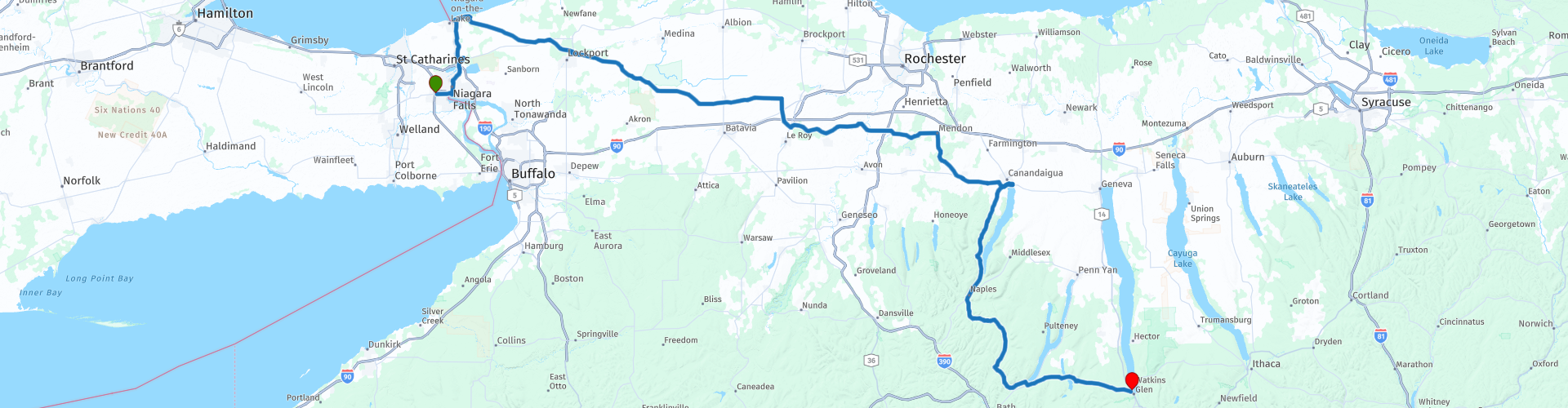
Niagara Falls to Watkins Glen visiting The Finger Lakes

Esta ruta fue hecha por:
RouteXpert Nick Carthew - (MRA Master)
Última edición: 23-12-2020
 Resumen de ruta
 Esta ruta utiliza el Puente del Arco Iris para el cual hay un peaje: $ 4.00 US o $ 5.25 Can.
Después de cruzar de regreso a los Estados Unidos y visitar Fort Niagara y el Lago Ontario, esta ruta se dirige a las tierras de cultivo del estado superior de Nueva York. Todos los caminos tienen una buena superficie y son relativamente libres de tráfico mientras te diriges a The Finger Lakes.
Las atracciones y el paisaje junto al lago es la razón por la que le otorgué 4 estrellas **** a esta ruta.
 Compartir esta ruta


Animation

Veredicto


Duración
5h 3m

Modo de viaje
Coche o motocicleta

Distancia
312.30 km

Países


 Revisión de RouteXpert
 Después de salir del hotel y llenar su tanque, la ruta lo llevará por el Puente del Arco Iris. Se recomienda comenzar temprano para evitar las multitudes y disfrutar de las vistas mientras cruza.
La construcción del puente Rainbow comenzó en mayo de 1940 y se abrió el 1 de noviembre de 1941. La cubierta del puente está a 202 pies (61,5 m) sobre el agua y 950 pies (289,5 m) de longitud. La corriente de agua debajo de este puente promedia 26-30 millas por hora. La profundidad del agua es superior a 175 pies (53 m). En un minuto se estima que seis mil millones (6,000,000,000) de libras de agua cruzan debajo del Puente Rainbow. Los estribos de los puentes están a 50 pies (15 m) sobre el agua para evitar daños por el hielo en el río que accidentalmente destruyó el anterior Puente de luna de miel en enero de 1938.
Después de pasar la aduana, tome la segunda salida a la izquierda hacia Niagara Scenic Parkway en dirección norte. Esta es una ruta bastante nueva y es posible que no se muestre en su dispositivo GPS, permanezca en Niagara Scenic Parkway y su dispositivo retomará la ruta nuevamente después de 2 millas en RP 7. Luego tendrá la oportunidad de girar a la izquierda para visitar el Niagara Whirlpool. Se estima que el remolino se formó hace unos 4.200 años por la erosión. Es todo un espectáculo ver los grandes volúmenes de agua convertirse en una confusión desde esta posición elevada.
Fort Niagara es el siguiente, situado en Fort Niagara State Park, lo que significa que hay un pequeño peaje a pagar en la entrada, sin embargo, vale la pena visitar el fuerte.
Fort Niagara y el sitio que ocupa están llenos de historia. Los franceses construyeron la primera estructura en 1678 como base para el explorador y comerciante de pieles francés René-Robert Cavelier, Sieur de La Salle.
A lo largo de los años, el sitio ha sido combatido y ocupado muchas veces y una visita al museo en el fuerte es imprescindible.
También estará en la orilla del lago Ontario, la quinta y última de los Grandes Lagos en este recorrido.
El lago Ontario es el más oriental de los Grandes Lagos y el más pequeño en superficie (7.340 millas cuadradas, 18.960 km2).
El nombre del lago Ontario proviene de la lengua iroquesa y significa 'Lago de aguas brillantes'. Las Primeras Naciones fueron las primeras en vivir en la cuenca, llegando hace unos 7,000 años. Hoy, el lago Ontario es el hogar, y una fuente de agua potable, para 9 millones de personas que viven en Ontario, Canadá y el estado de Nueva York, EE. UU.
Dejar atrás los Grandes Lagos no significa que sea el final del recorrido, ¡ni mucho menos! Hoy visitamos 3 de Nueva York Finger Lakes.
A los pocos minutos de salir de los Grandes Lagos, se encontrará en un paisaje rural pasando casas de badajo en el camino a una parada de café y perritos calientes en el borde de la ciudad de Lockport. Reid's es solo una cabaña al costado de la carretera, pero según muchos, sirven el mejor café y perritos calientes en el estado de Nueva York y es una parada preferida para muchos ciclistas.
La ciudad de Lockport, creció a orillas de la maravilla de la ingeniería del siglo XIX, el Canal Erie. Originalmente, el canal de Erie corría durante 583 km (363 millas) desde el río Hudson en Albany hasta el lago Erie en Buffalo. Fue construido para crear una ruta navegable de agua desde la ciudad de Nueva York y el Océano Atlántico hasta los Grandes Lagos. Cuando se completó en 1825, fue el segundo canal más largo del mundo (después del Gran Canal en China) y mejoró enormemente el desarrollo y la economía de Nueva York, Nueva York y Estados Unidos. Pasarás por este canal histórico cuando salgas de Lockport y te dirijas a tierras de cultivo abiertas.
15 minutos a lo largo del camino y entrará al Área de Manejo de Vida Silvestre de Tonawanda y luego al Refugio Nacional de Vida Silvestre Iroquois. El área de manejo de vida silvestre está ubicada en un área pantanosa que históricamente ha sido un punto de parada para las aves migratorias. Las especies de mamíferos que habitan en este refugio incluyen venados de cola blanca, especies de ardilla, puercoespín, rata almizclera, mapache, coyote, mofeta, castor, especies de ardilla listada, nutria de río, dos especies de zorro, gato montés, visón, zarigüeya y marmota. ¡Mantén tus ojos abiertos para cualquiera de estos!
Poco después, seguirás el Oatka Creek hacia el pequeño pueblo de Scottsville. Aquí encontrarás Dirty Dave's Bar and Grill, otra parada preferida para los ciclistas, así que he sugerido una parada de café aquí.
La ruta ahora está entrando en la región de Finger Lakes.
La región de Finger Lakes abarca aproximadamente 80 millas (130 km) de este a oeste y 50 millas (80 km) de norte a sur. Hay 11 Finger Lakes en total, que van desde muy pequeños (Canadianice de aproximadamente 4 millas de largo) a muy grandes (Cayuga de más de 38 millas (60 km) de largo). El primero de los 3 Finger Lakes que visita esta ruta es el lago Canandaigua en Canandaigua y con 15.5 millas (24.9 km) de largo, 1.5 millas (2.4 km) de ancho es el cuarto más grande. He sugerido una parada para almorzar aquí en Jose & Willy's at the Lake. Nuevamente, esta es una parada preferida para motocicletas y puedes disfrutar de un buen almuerzo mientras miras a través del reluciente lago.
Después del almuerzo, la ruta se dirige hacia el sur por la Ruta Estatal 21, este es un gran camino que gira y gira y ondula hacia arriba y hacia abajo, disfrute. El pueblo de Hammondsport, conocido como el centro de la industria del vino de Nueva York, está situado en la orilla de otro de los Finger Lakes, el lago Keuka.
El lago Keuka es inusual porque tiene forma de Y, en contraste con la forma larga y estrecha de los otros Finger Lakes. Fue aquí donde el reverendo Bostwick plantó las primeras uvas en la región en 1829 y donde se fundó Pleasant Valley Wine Company (la primera bodega en la región y la primera bodega consolidada en el país) en 1860. He sugerido otra ¡parada de café aquí y tal vez un paseo por el pueblo para abastecer la bodega!
El pionero de la motocicleta y la aviación, Glenn Curtiss, puso a Hammondsport en el mapa a principios del siglo XX al convertirse en el hombre más rápido del mundo y más tarde en ser conocido como el "Padre de la aviación naval". Hay un museo realmente bueno para visitar aquí con motocicletas, automóviles y aviones como exhibiciones. Glenn Curtiss comenzó su carrera como constructor de bicicletas y luego motocicletas. En 1907 se convirtió en el "hombre más rápido del mundo" cuando alcanzó una velocidad de 136.4 MPH en su motocicleta con motor V8. Una reproducción exacta de esta bicicleta es una de varias motocicletas Curtiss que se exhiben. El 4 de julio de 1908, Curtiss ganó notoriedad de un tipo diferente cuando voló su máquina voladora, llamada "June Bug", una distancia de más de 5000 pies para ganar el Trofeo Scientific American. Este fue el primer vuelo público anunciado previamente en Estados Unidos, una hazaña que le valió la licencia de piloto # 1. Una reproducción de tamaño completo del "June Bug" es uno de varios aviones históricos en exhibición.
El final de la ruta está a solo 30 minutos en Watkins Glen.
Watkins Glen está situado en la orilla del lago Seneca, el segundo más largo pero más grande en volumen y el tercero de los Finger Lakes que visita esta ruta.
Watkins Glen es quizás más famoso por el circuito de carreras. Comúnmente apodado "The Glen" (pero en realidad los lugareños lo llaman "Watkins"), Watkins Glen organizó el Campeonato Mundial de Fórmula Uno de la FIA de 1961 a 1980. El circuito está a solo unos minutos en las afueras de la ciudad.
El final de la ruta es en el hotel Watkins Glen Harbor, que tiene excelentes vistas del lago, y debido a la proximidad del circuito de carreras, hay muchas otras opciones disponibles para el alojamiento.


 Enlaces
  Uso
Uso ¿Quiere descargar esta ruta?
Puede descargar la ruta gratis sin la cuenta de MyRoute-app. Para hacerlo, abra la ruta y haga clic en 'guardar como'. ¿Quiere editar esta ruta?
No hay problema, comience abriendo la ruta. Siga el tutorial y cree su cuenta personal de MyRoute-app. Después de registrarse, su prueba comienza automáticamente.  Descargo de responsabilidad
El uso de esta ruta GPS es por su cuenta y riesgo. La ruta ha sido cuidadosamente compuesta y verificada por un RouteXpert acreditado por MyRoute-app para su uso en TomTom, Garmin y MyRoute-app Navigation.
No obstante, es posible que se hayan producido cambios debido a circunstancias cambiantes, desvíos de carreteras o cierres estacionales. Por lo tanto, recomendamos comprobar cada ruta antes de utilizarla.
Utilice preferentemente el track de ruta en su sistema de navegación. Más información sobre el el uso de la aplicación MyRoute se puede encontrar en el sitio web en 'Comunidad' o 'Academia'.

Ontario
Acerca de esta región
Ontario (pronunciación en inglés: /ɒnˈtɛəɹi.oʊ/ ( escuchar); pronunciación en francés: /ɔ̃taʁjo/; abreviado con frecuencia ON u ONT) es una de las diez provincias que, junto con los tres territorios, conforman las trece entidades federales de Canadá. En ella se localizan dos de las mayores ciudades canadienses, Toronto, y Ottawa, esta última la capital del país. la provincia está ubicada en el centro-este de la nación, limitando al norte con la bahía de Hudson, al este con Quebec, al sur con los Grandes Lagos y el río Niágara que la separan de Estados Unidos, y al oeste con Manitoba. Con 14.279.196 habitantes en 2017 —más de un tercio de la población del país— es la entidad más poblada, con 1.076.395 kilómetros cuadrados, la cuarta más extensa —por detrás de Nunavut, Quebec y Territorios del Noroeste— y con 12 hab/km², la tercera más densamente poblada, por detrás de Isla del Príncipe Eduardo y Nueva Escocia.[3] La península de Ontario (en la costa de los Grandes Lagos) constituye el punto más meridional de todo Canadá.
Ontario es un atractivo turístico al conocer Canadá por su cultura, sus etnias y su belleza natural.
La principal fuente de ingresos de Ontario es la industria. El valor de los productos industriales producidos en Ontario es mayor que la suma del valor total de los productos industriales fabricados en todas las otras provincias y territorios de Canadá. La fuerza de su industria manufacturera le valió el apodo de Manufacturing Heartland of Canada (Corazón Industrial de Canadá).[4]La provincia se destaca principalmente por su fuerte industria automotriz[4] —la más competitiva de todo el continente americano con excepción de Míchigan en Estados Unidos. Otras fuentes importantes de ingresos son el turismo y la prestación de servicios financieros e inmobiliarios.
El origen de su nombre deriva del lago del mismo nombre, el lago Ontario, nombre dado por los iroqueses, que significa «lago hermoso» o «aguas brillantes».[4] Ontario fue colonizado inicialmente por los franceses, pasando a formar parte de la colonia francesa de Canadá, una de las provincias coloniales de Nueva Francia, que entonces incluía la región sur de las actuales provincias canadienses de Ontario y de Quebec.
En 1763, el Reino de Gran Bretaña anexó Canadá. En tres décadas, los anglófonos se convirtieron en mayoría en el suroeste de la colonia, motivo por el cual el Reino Unido decidió dividir la colonia en dos en 1791. Ambas divisiones fueron reunidas nuevamente en 1840, en una única provincia de Canadá. Con la independencia de Canadá, el 1 de julio de 1867, la provincia de Canadá fue definitivamente separada en dos, en las actuales provincias de Ontario y de Quebec. En sus inicios una potencia agraria, Ontario pasó a ser un gran centro industrial a comienzos del siglo XX, y se convirtió en el principal centro económico del país durante las décadas de 1960 y de 1970.[4]
En agosto de 2006, residían en la provincia 12 792 619 ontarienses,[5] lo que representa aproximadamente el 37,9 % de la población total canadiense, repartidos por un área de 1 076 395 km².[6]
Leer más en Wikipedia
Ontario es un atractivo turístico al conocer Canadá por su cultura, sus etnias y su belleza natural.
La principal fuente de ingresos de Ontario es la industria. El valor de los productos industriales producidos en Ontario es mayor que la suma del valor total de los productos industriales fabricados en todas las otras provincias y territorios de Canadá. La fuerza de su industria manufacturera le valió el apodo de Manufacturing Heartland of Canada (Corazón Industrial de Canadá).[4]La provincia se destaca principalmente por su fuerte industria automotriz[4] —la más competitiva de todo el continente americano con excepción de Míchigan en Estados Unidos. Otras fuentes importantes de ingresos son el turismo y la prestación de servicios financieros e inmobiliarios.
El origen de su nombre deriva del lago del mismo nombre, el lago Ontario, nombre dado por los iroqueses, que significa «lago hermoso» o «aguas brillantes».[4] Ontario fue colonizado inicialmente por los franceses, pasando a formar parte de la colonia francesa de Canadá, una de las provincias coloniales de Nueva Francia, que entonces incluía la región sur de las actuales provincias canadienses de Ontario y de Quebec.
En 1763, el Reino de Gran Bretaña anexó Canadá. En tres décadas, los anglófonos se convirtieron en mayoría en el suroeste de la colonia, motivo por el cual el Reino Unido decidió dividir la colonia en dos en 1791. Ambas divisiones fueron reunidas nuevamente en 1840, en una única provincia de Canadá. Con la independencia de Canadá, el 1 de julio de 1867, la provincia de Canadá fue definitivamente separada en dos, en las actuales provincias de Ontario y de Quebec. En sus inicios una potencia agraria, Ontario pasó a ser un gran centro industrial a comienzos del siglo XX, y se convirtió en el principal centro económico del país durante las décadas de 1960 y de 1970.[4]
En agosto de 2006, residían en la provincia 12 792 619 ontarienses,[5] lo que representa aproximadamente el 37,9 % de la población total canadiense, repartidos por un área de 1 076 395 km².[6]
Ver región
 Estadísticas
  18
18Cantidad de revisiones de RX (Ontario)
 11671
11671Cantidad de visitantes (Ontario)
 554
554Cantidad de descargas (Ontario)
 Ruta de colecciones en esta región
 El mejor tour de los Grandes Lagos
Este es un recorrido desde Chicago a Staten Island, Nueva York, visitando los 5 Grandes Lagos de América del Norte.
A partir del alquiler de motocicletas EagleRider en Illinois Harley-Davidson en Chicago y terminando en el alquiler de motocicletas EagleRider en Staten Island.
El último recorrido por los Grandes Lagos es una ruta a través de los Estados Unidos y Canadá hacia destinos pintorescos a lo largo de los Lagos Michigan, Superior, Huron, Erie y Ontario.
¿Qué son los Grandes Lagos? Los Grandes Lagos son una serie de cinco lagos de agua dulce interconectados ubicados en la frontera de los Estados Unidos y Canadá. Son el grupo más grande de lagos de agua dulce en el mundo por área y tienen características marinas como olas ondulantes, fuertes corrientes, kilómetros de playas arenosas y rocosas y horizontes distantes. Este recorrido de 8 rutas incluye lugares para tomar un café, comer y pasar la noche en hoteles. También visita sitios históricos y pintorescos conocidos en el camino, evitando principalmente las autopistas principales. He sugerido 2 noches en el Lago Superior y 2 noches en las Cataratas del Niágara, lo que hace que este sea un recorrido de 10 días, pero por supuesto, eso depende de usted. El paisaje y los paisajes son impresionantes y cada día es diferente al siguiente. Por favor, disfruta.
Ver colección de rutas
Trans Canada Highway
La carretera transcanadiense (TCH) o la carretera transcanadiense es un sistema de carreteras que cubre las 10 provincias de Canadá.
El Sistema Federal y Provincial de Carreteras que ahora forma el TCH fue autorizado por la Ley de Carreteras Transcanadienses de 1948 y se inauguró en 1962. Fue terminado en 1971. La longitud total del TCH es de 7821 km.
A diferencia del Sistema de autopistas interestatales de los Estados Unidos, el TCH no consiste en una red inequívoca de autopistas, sino que forma una red de autopistas de acceso limitado y otras rutas principales más parecidas a las carreteras provinciales holandesas. La ruta está indicada por un escudo verde con una hoja de arce blanca.
La numeración de las carreteras que forman parte del TCH es el dominio de las provincias. Solo las provincias occidentales han alineado su numeración y el TCH tiene la designación de Autopista 1 allí.
La ruta principal del TCH comienza en Victoria en Columbia Británica y se extiende a través de Calgary y Regina hasta Winnipeg. Desde Winnipeg, la ruta conduce a Kenora en Ontario, después de lo cual varias ramas pasan por Ontario a Ottawa.
Más al este, la ruta pasa por la provincia de Quebec a través de Montreal y Quebec, entre otros, a Moncton, Nuevo Brunswick. Luego, el TCH continúa hacia el este a través de Nueva Escocia, donde una rama (a través del Puente de la Confederación) conduce a la Isla del Príncipe Eduardo. Otra sección desciende hasta el mar en la ciudad portuaria de Sydney, donde sale un servicio de ferry hacia Channel-Port aux Basques en la isla de Terranova. Desde allí, la ruta continúa durante más de 900 km hasta la capital provincial de St. John's, en el extremo sureste de la isla.
No solo conducimos el TCH, sino que tomaremos los caminos rurales tanto como sea posible, porque solo conducir en la autopista es demasiado aburrido y Canadá tiene muchos caminos hermosos a través de su hermoso paisaje. Conduce por todas las provincias y por paisajes muy variados y pintorescos, desde las Montañas Rocosas del Oeste, las Praderas Centrales hasta las Marítimas del Este y el Bosque del Norte.
La temporada de equitación es generalmente de abril a octubre, con temporadas más largas en la costa oeste y el sur de Ontario. Proporcione ropa buena durante toda la temporada o traiga ropa de lluvia, dependiendo de la provincia y la temporada, el clima puede cambiar y puede sorprenderse con la lluvia o incluso con la nieve o granizo, así que prepárese.
En Canadá se utiliza el sistema métrico, por lo que las velocidades se indican en Km / h. Se aplica un requisito de casco (aprobado por el DOT) en todo Canadá.
Verá mucha vida salvaje en todo Canadá. Esto varía de provincia a provincia, como ciervos, búfalos, alces, caribúes, lobos, pumas, osos, cabras montesas, ovejas, linces, coyotes, zorros, mapaches, tejones, diversos roedores y todo tipo de aves. Incluso si es muy tentador detenerse para una foto, no lo haga, puede ser muy peligroso.
Las rutas descritas en esta revisión a veces se desvían de la Trans Canada Highway, lo que lleva la longitud total a 9.300 kilómetros. Las rutas se realizan para que conduzca a través de las hermosas partes de Canadá con panoramas realmente hermosos y hermosos lugares para visitar, esto difiere de museos, parques y puntos históricos. Las rutas no son demasiado largas, por lo que hay tiempo para detenerse para tomar fotos y lugares de interés en el camino. También puede elegir organizar y combinar las etapas de manera diferente o agregar otras rutas para acortar o extender su viaje. Las rutas están marcadas con una calificación en estrellas, algunas rutas son menos desafiantes o interesantes, pero son necesarias para conducir al siguiente punto, por lo que a menudo tienen una calificación más baja.
En la descripción de la ruta encontrará más detalles sobre las rutas y los puntos de interés a lo largo del camino. Estos puntos y también hoteles, restaurantes, estaciones de servicio, etc. se indican con un PDI y, a veces, también con un punto de ruta. En la descripción también encontrará enlaces a sitios interesantes y a las rutas que se conectan a ese día.
Las rutas descritas son;
Día 01 TCH Victoria a Nanaimo
Día 02 TCH Nanaimo a Hope
Día 03 TCH Esperanza a Kamloops
Día 04 TCH Kamloops a Revelstoke
Día 05 TCH Revelstoke a Lake Louise
Día 06 TCH Lake Louise a Calgary
Día 07 TCH Calgary a Medicine Hat
Día 08 TCH Medicine Hat a Moose Jaw
Día 09 TCH Moose Jaw a Regina
Día 10 TCH Regina a Brandon
Día 11 TCH Brandon a Winnipeg
Día 12 TCH Winnipeg a Kenora
Día 13 TCH Kenora a Ignace
Día 14 TCH Ignace a Thunder Bay
Día 15 TCH Thunder Bay a Maratón
Día 16 Thunder Bay a Wawa
Día 17 TCH Wawa a Sault Ste Marie
Día 18 TCH Sault Ste Marie a Española
Día 19 TCH Española a Mattawa
Día 20 TCH Mattawa a Ottawa
Día 21 TCH Ottawa a Montreal
Día 22 TCH Montreal a Quebec
Día 23 TCH Quebec a Riviere du Loup
Día 24 TCH Riviere du Loup a Grand Falls
Día 25 TCH Grand Falls a Fredericton
Día 26 TCH Fredericton a Moncton
Día 27 TCH Moncton a Charlottetown
Día 28 TCH Charlottetown a Truro
Día 29 TCH Truro a North Sydney
Día 30 TCH North Sydney a Corner Brook
Día 31 TCH Corner Brook a Grand Falls
Día 32 TCH Grand Falls a Clarenville
Día 33 TCH Clarenville a St John.
Diviértete leyendo las reseñas y planeando tu próximo viaje por carretera.
Si ha conducido este viaje, ¡tengo mucha curiosidad por sus comentarios!
Ver colección de rutas