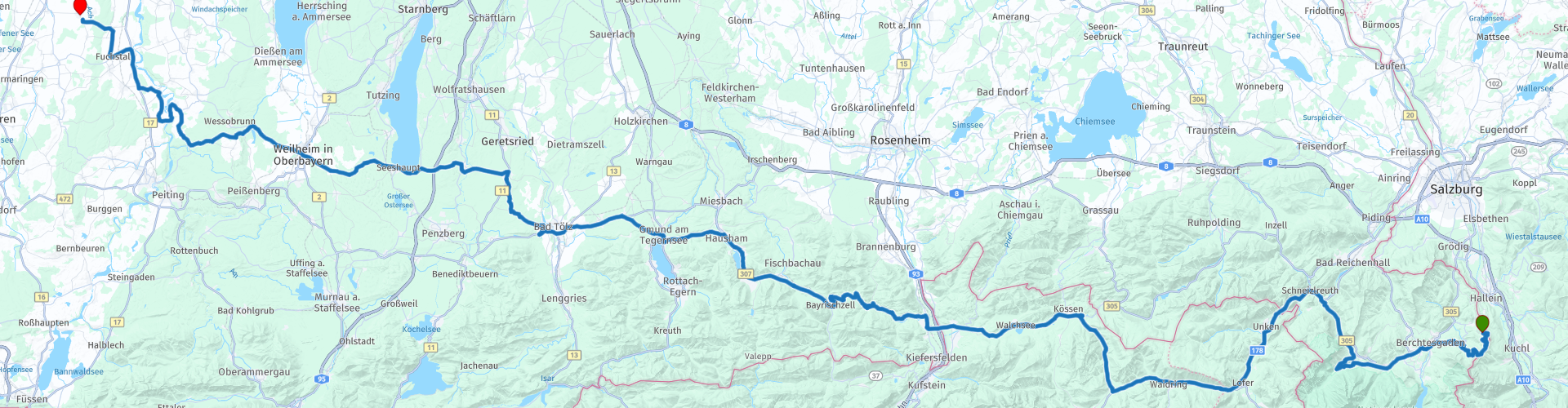
16 From Berchtesgaden to Waal via Rossfeldstrasse and Kehlstein

Questo percorso è stato creato da:
RouteXpert Leonor Orban - Sr. RouteXpert
Ultima modifica: 15-01-2021
 Riepilogo percorso
 Lo scopo di questo viaggio è tornare nei Paesi Bassi in modo piacevole. Solo uno spettacolo che richiede molto tempo è incluso nell'itinerario: una visita alla Kehlsteinhaus. Con questa lunga visita arriverete in tempo anche alla vostra destinazione finale a Waal.
Lungo il percorso si percorrono varie strade di valico, come Roßfeld Panoramastraße, Schwarzbachwacht, Kniepass, Paß Strub e Sudelfeldpass e si ha una vista su numerosi laghi e fiumi bellissimi. Tutto sommato, questo rende un meraviglioso percorso da percorrere chilometri, senza strade tecnicamente impegnative, attraverso le Berchtesgadener Alpen, attraverso il Tirolo e la turistica Strada alpina tedesca fino alla destinazione finale della vostra vacanza.
 Condividi questo percorso


Animation

Verdetto


Durata
8h 13m

Modalità di viaggio
Auto o moto

Distanza
269.65 km

Paesi


 Revisione RouteXpert
 Per arrivare subito al punto: una volta usciti dall'hotel, svoltare direttamente in Roßfeld Panoramastraße (rp 3). Sarai uno dei primi ad arrivare al casello di Via Panorama, dopodiché percorrerai l'elegante e panoramica strada in tutta solitudine e salirai a quota 1570m.
Negli anni tra la prima e la seconda guerra mondiale, si è deciso di costruire un'autostrada alpina per aprire le aree delle Alpi di Berchtesgadener, in particolare il tratto da Lindau sul Lago di Costanza a Schönau sul Königssee. A quel tempo non era ancora possibile costruire la panoramica Roßfeldstraat. Fu solo nel 1937, anno in cui aveva già preso forma l'Autostrada Alpina (Deutsche Alpenstrasse), che si decise di costruire la Panorama Street. All'epoca in cui scoppiò la seconda guerra mondiale, solo un pezzo di circa 800 m non era stato ancora completato abbastanza lontano, quindi la strada non poteva essere ufficialmente aperta. Panorama Street non fu completamente completato fino a dopo la seconda guerra mondiale e fu ufficialmente inaugurato nel 1955.
Oggi la Panorama Street è molto frequentata. Come motociclista ti godrai principalmente le numerose viste qui. Lungo il percorso ci sono anche molte opportunità per fermarsi e scattare foto dei magnifici panorami della valle del Salzach, delle Alpi di Salisburgo, della stessa città di Salisburgo, delle Alpi Dachsteiner, delle "Totes Gebirge" (montagne morte) e del famigerato Kehlstein- montagna. In altre parole: i tuoi occhi saranno a corto di strada! Non dimenticare di prestare attenzione alla strada ogni tanto. La Panorama Street offre anche un numero modesto di meravigliose curve (tornanti).
Verso la fine della strada panoramica hai la possibilità di visitare un luogo speciale con una storia carica: il Kehlsteinhaus (rp 4). Negli anni immediatamente precedenti la seconda guerra mondiale, fu completata la costruzione della Kehlsteinhaus (Nido dell'Aquila), sotto la direzione di Albert Speer. L'NSDAP desiderava costruire la casa su questo sito quasi impossibile, al fine di mostrare alle persone il loro potere illimitato. La casa è costruita su una montagna con pendii a volte incredibilmente ripidi. La strada per arrivarci era così complessa che l'inventore dell'autostrada tedesca dovette essere assunto per renderla possibile. La cima non poteva essere raggiunta su strada, quindi gli ultimi 124 m sono stati coperti da un ascensore placcato in oro.
Negli anni che seguirono, la casa fu ampiamente visitata e utilizzata dai membri del NSDAP, nonché da Eva Braun (la compagna di Hitler) e dalla sua famiglia. Lo stesso Hitler ha visitato la casa solo poche volte.
Dopo la seconda guerra mondiale la funzione dell'edificio fu modificata. Da status symbol accessibile solo all'élite, è stato trasformato in un ristorante accessibile a tutti. Tutti i simboli che ricordavano la dittatura nazista furono rimossi. Oggigiorno puoi guardarti intorno nell'edificio e mangiare e / o bere qualcosa nel ristorante. Se vuoi saperne di più sulla storia, puoi visitare il centro di documentazione di Obersalzberg. Non dimenticare di camminare intorno alla cima della montagna nonostante il posto caricato. Da qui hai una magnifica vista dell'ambiente che ti circonda. Anche il viaggio con l'autobus sulla stretta strada di montagna ti lascerà un ricordo indelebile.
Dopo questo centro di gravità carico, il resto della corsa è principalmente caratterizzato dalla guida. Prima di ammirare un po 'dell'Austria, è meraviglioso attraversare il paesaggio delle Alpi di Berchtesgadener. Se hai tempo e desideri, puoi guidare fino alla fine della Deutsche Alpenstrasse: Schönau al Königssee. Alla rp5 è meglio deviare dal percorso alla rotonda e seguire la segnaletica per il lago. Lungo il percorso è previsto un giro lungo l'Hintersee (rp 8), un lago relativamente piccolo e sconosciuto. Incredibile rendersi conto che questo lago è stato creato dopo che una buona quantità di rocce rotolò giù dalla montagna e si schiantò qui circa 4000 anni fa. Questa violenza grossolana ha portato a un'attrazione turistica pittoresca e nascosta.
Una volta tornati sulla strada principale, alcuni semplici ma piacevoli passaggi sono nel menu. Lo Schwarzbachwacht si trasforma nel Kniepass e poi nel Paß Strub. Appena percettibile si supera ogni volta le "alture del passo". Sono visibili l'attraversamento del fiume Saalach (rp 11) (meglio noto agli olandesi come un villaggio sciistico con lo stesso nome, attraverso il quale scorre anche questo fiume) e il viaggio oltre il castello di Oberrein (rp 12). Risalente al XIV secolo, questo castello offre una vista imponente dalla strada ed è nelle mani dello stato dal XX secolo ed è ora un luogo maestoso dove i bambini con disabilità vengono guidati nel loro cammino verso un lavoro.
Sul Kniepass (rp 13) e Paß Strub (rp 14), se guidi un po 'più lentamente, sarai anche in grado di riconoscere in lontananza i resti di antiche fortificazioni. La posizione e le dimensioni dei passi li hanno resi luoghi eccellenti per il controllo del traffico e per il pedaggio necessario. Fortunatamente, i pedaggi non sono più richiesti su questi tratti di strada, quindi puoi continuare la tua strada attraverso l'Austria senza preoccupazioni.
È meraviglioso godersi un'ultima volta nelle Alpi austriache. Al Ristorante Brandauerhof (rp 16) potete fare una pausa, godervi il panorama, pranzare deliziosamente e - magari prima di pranzo - scendere da una montagna con la pista per slittini locale adiacente al ristorante.
A rp 17 si attraversa l'Inn e si saluta subito l'Austria. Per parte dei suoi 518 km di lunghezza, questo fiume funge da confine tra Germania e Austria. Ha la sua sorgente in Engadina (Svizzera) e si ricollega con il Danubio a Passau (Germania).
Dopo aver salutato l'Austria, hai la possibilità di visitare Burgruine Auerburg. Dopo il rp 18 girare a sinistra (invece di seguire il percorso) e dopo circa 200m sulla sinistra ci sono dei cartelli segnalati che segnano il rudere. Non rimane molto dell'antica fortezza, ma offre una grande opportunità per fare una pausa e sgranchirsi le gambe e ammirare i lama che pascolano qui intorno.
Dopo aver lasciato Oberauerburg la strada si snoda in direzione ovest verso le cascate di Tatzelwurm (rp 19). Qui puoi anche fare una pausa facoltativa e sgranchirti le gambe. Il Tatzelwurm è costituito da 2 cascate, che sono nascoste nel profondo della gola. Con una passeggiata di 40 minuti sei a casa e via. Durante la passeggiata, attenzione: il Tatzelwurm è un animale mitico che viene regolarmente avvistato qui. Ma forse le cascate devono il loro nome a un motociclista medievale: la strada in questa zona sembra un Tatzelwurm sulla mappa. La strada prosegue lunga e tortuosa. Insomma, ottimo per guidare e godersi il viaggio.
In questo tratto si passano anche numerosi laghi. Lo Schliersee (rp 21), il Tegernsee (rp 22) e lo Zellsee (rp 27). I primi 2 laghi sono laghi naturali e famose attrazioni per il nuoto e la vela. Lo Zellsee, invece, è di natura artificiale. Il lago fu creato nel 1414 dopo che il vescovo Höhenkirchen sbarrò il fiume Rott per aumentare la pesca per il suo amato monastero in riva al lago. Oggi il lago è di proprietà privata e un santuario degli uccelli protetto di 161 acri. Poco prima di scendere lungo il lago, fermati al Landgasthof Schöntag (rp 26). Anche se il punto finale di Waal (Gasthaus zur Post) dista solo 45 minuti in auto, puoi comunque goderti le strade in leggera pendenza.
Il percorso riceve 4 stelle. È meraviglioso guidare in questa regione. I passi di montagna volano sotto le ruote, ma di solito senza molto spettacolo. Questa mancanza di spettacolo è più che compensata dalla facilità con cui si guida attraverso il bellissimo paesaggio ondulato. Lungo il percorso puoi sgranchirti le gambe regolarmente e visitare una serie di luoghi speciali, come la vista sulla Roßfeld Panoramastraße, la Kehlsteinhaus e le cascate di Tatzelwurm.


 Collegamenti
  Utilizzo
 Vuoi scaricare questo percorso?
Puoi scaricare il percorso gratuitamente senza un account MyRoute-app. Per farlo, apri il percorso e fai clic su 'Salva con nome'. Vuoi modificare questa rotta?
Nessun problema, inizia aprendo il percorso. Segui il tutorial e crea il tuo account MyRoute-app personale. Dopo la registrazione, la tua prova inizia automaticamente.  Disclaimer
L'utilizzo di questo percorso GPS è a tue spese e rischio. Il percorso è stato accuratamente composto e controllato da un RouteXpert accreditato dall'app MyRoute per l'utilizzo su TomTom, Garmin e navigazione dell'app MyRoute.
Ciononostante potrebbero essersi verificati cambiamenti a causa di mutate circostanze, deviazioni stradali o chiusure stagionali. Si consiglia pertanto di controllare ciascun percorso prima dell'uso.
Utilizzare preferibilmente la tracklog del percorso nel sistema di navigazione. Maggiori informazioni sul l'uso dell'app MyRoute può essere trovato sul sito Web in 'Community' o 'Academy'.