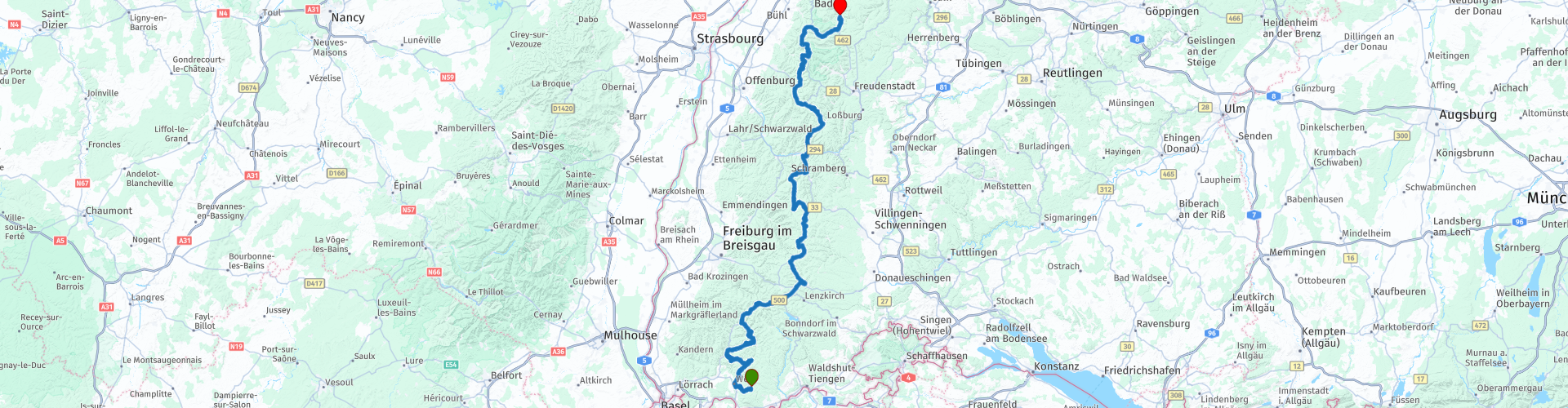
R05 - Rickenbach to Forbach

This route was brought to you by:
RouteXpert Arno van Lochem - Senior RX
Last edit: 25-08-2021
 Route Summary
 With an area of almost 10,000 km2 and heights up to 1500m, beautiful roads must be built. And it is! This route covers part of it.
This route runs from Rickenbach on beautiful roads with even more beautiful views towards the north of the Black Forest via the highest point of the Black Forest, Feldberg and the Titisee. The B500, the Schwarzwaldhochstrasse, is also partly followed. Be surprised by all the beauty that the Black Forest has to offer.
 Share this route


Animation

Verdict


Duration
7h 21m

Mode of travel
Car or motorcycle

Distance
252.90 km

Countries

 RouteXpert Review
 The route starts in Rickenbach, a small village in the south of the Black Forest. On beautiful winding roads through endless forests and meadows you drive on the L155, which sends you north via Wehr. At the small village of Au, turn left onto the K5352. This is typically such a road where you immediately enjoy yourself and if the navigation says that you have to turn left or right after x meters, that is quite a small disappointment. Don't be sad for too long, there are still many, many beautiful things to come under the wheels in this route.
At the viewpoint Kreuzbuhl you have the option to stop and enjoy the view. You look out over the town of Gaisbuhl and the mountains behind, a typical piece of beauty from the Black Forest.
Not much further you come via the L146 over the St. Antoni pass with a height of 1051 meters. A pass with a number of hairpin bends and beautiful views, it is visible that you are again on a somewhat higher part of the Black Forest. The 'roof of the Black Forest', however, is the Feldberg, which is 25 kilometers further on the route. This highest mountain in the Black Forest is 1493m. The route does not get that high, it ends at the Feldberg Pass with an altitude of 1231m. The terrace of Hotel Kokoschinski offers a great view, which is why you should enjoy a cup of coffee there.
When you arrive in Feldberg, the Schnapsmuseum can be visited. Lovers of vintage motorcycles and all kinds of schnapps will get their money's worth here: the schnapps museum in Café zum Gscheiten Beck introduces you to the art of distilling schnapps and offers guided tours with tasting. Prefer something sweet? That is also possible, in the cafe delicious homemade cakes are available.
You continue the route on a small piece of B317 towards the Titisee. This is a lake with an area of 1.3 km² and an average depth of 20m. Although it is hefty size, it is certainly not the largest lake in this area. Yet many tourists come every year. There is always plenty to do at the lake. The most popular activity is a walk around the lake. The nearby Hochfirst mountain offers a lookout tower at an altitude of 1,192 meters. A hike from the lake to this point is also highly recommended. Cycling in the region is a popular choice, although it requires considerable effort due to the height differences. It is also good to stay on the water. For example, it is possible to take a boat trip, in a large tour boat or, for example, in a pedal boat. Swimming in the lake is possible, but there are also swimming pools around the lake.
After Neustad you follow the L128, which ends up on the B500, or the Schwarzwaldhochstraße. This road, which runs almost through the entire Black Forest, is almost 233 km long and consists of two parts. The northern part starts at Wintersdorf and runs via Baden-Baden to Alexanderschanze. The southern section starts at Triberg im Schwarzwald and runs via Titisee-Neustadt to Waldshut-Tiengen.
There are hardly any places on the route, especially south of Baden-Baden. Between Baden-Baden and Kniebis, the road forms part of the touristically interesting Schwarzwaldhochstraße. Here the route rises to a maximum of more than 1,000 meters. The road is very beautiful, and there are often views of the Rheintal and the Vosges. The southern part is also at an altitude of more than 1,000 meters and runs along a number of lakes. That part is also touristy.
Shortly before Triberg you leave the B500 to drive on the K5751 towards Schonach im Schwarzwald. Just before reaching this place it is possible to stop at the Langenwaldschanze. This is a 106m high ski jump that has been around for almost 100 years. The ramp was built in 1924. Renovated several times over the years to meet the latest requirements and wishes. For example, in 2010 the redoubt was enlarged by 2.25 million euros.
Nice to take a look at this rather immense building. In addition, the hill on which the redoubt is built offers a beautiful view of Schonach im Schwarzwald.
In Schonach im Schwarzwald you turn left onto the L109. A truly fantastic road with beautiful curves and beautiful views. Did I say above that you are sometimes disappointed when you have to leave a road, this is one of them. But don't worry, after Oberprechtal the steering party will happily continue a little further on the L107.
At Gutach you turn left and drive via the B33 towards Hausach. Once there, turn right and you will eventually come to the road with number L96. This beautiful winding road takes you towards Schapbach, but before you reach this place you turn left onto the L93. We arrive at Oppenau through countless bends. From there a little further to the north, towards All Saints' Day. Here we find the Wasserfälle Allerheiligen. Really worth a visit. Steps and plateaus have been built along the waterfall, from which you have a beautiful view of the splashing water. During the walk, also take a trip to the Studentenfelsen for a beautiful view over the valley.
At the top of the falls is the Klosterruine Allerheiligen. The All Saints Monastery was founded between 1191 and 1196. Many pilgrims have come to All Saints' Day since the late 13th century. The monastery thrived in the 18th century thanks to a nationally recognized secondary school located in it. After this school left, the buildings were empty and were auctioned for demolition in 1816. The remnants of the once-important complex did not regain attention until the nearby waterfalls opened with ladders and steps around 1840.
A visit to this ruin can be combined with a visit to the waterfalls. You can park at RP8 (at the bottom of the falls) or RP9 (at the top of the ruin).
A few kilometers further on, the K5370 that you just drove over ends up on the B500 at Ruhestein at an altitude of over 900 meters. The B500 really does justice to the section 'hoch' in its name Schwarzwaldhochstraße. It seems as if you are driving over the roof of the Black Forest, everywhere you look you have a great view. It is high time to put the engine aside and enjoy all this beauty while enjoying a cup of coffee or another snack. This is possible at Rasthütte Seibelseckle where they serve a good cup of coffee. Old shop with a great look!
Further on the route comes along the Mummelsee. The lake is located at an altitude of 1,036m, has an area of 3.7 hectares, a circumference of 800 meters and a maximum depth of 17 meters. As the lake is located along the Schwarzwaldhochstraße, it is one of the most visited lakes in Baden-Württemberg. Definitely stop at this beautiful lake. Don't forget to enjoy the view from the other side of the B500! Be careful when crossing the road!
At Hundseck you leave the B500 to reach Forbach via the last 25 kilometers of this route via the L80b, the L83 and the B462. The end point is at Hotel Das Waldhaus, a quiet hotel on the edge of the village. Next to the hotel is a wooden bridge, the 'Alte Forbacher Holzbrücke' over the river Murg. Sitting on the terrace of the hotel you look at the bridge. The bridge spans nearly 38 meters over the Murg and has no central pillar, with a dead weight of 129 tons, the massive wooden bridge carries a load capacity of 64 tons. The wooden bridge is the longest cantilevered, covered and, due to its stability, driveable wooden bridge in Europe.
Have fun driving this route!


 Links
Links  Usage
Usage Want to download this route?
You can download the route for free without MyRoute-app account. To do so, open the route and click 'save as'. Want to edit this route?
No problem, start by opening the route. Follow the tutorial and create your personal MyRoute-app account. After registration, your trial starts automatically.  Disclaimer
Use of this GPS route is at your own expense and risk. The route has been carefully composed and checked by a MyRoute-app accredited RouteXpert for use on TomTom, Garmin and MyRoute-app Navigation.
Changes may nevertheless have occurred due to changed circumstances, road diversions or seasonal closures. We therefore recommend checking each route before use.
Preferably use the route track in your navigation system. More information about the use of MyRoute-app can be found on the website under 'Community' or 'Academy'.

Baden-Württemberg
About this region
Baden-Württemberg (; German: [ˌbaːdn̩ ˈvʏʁtəmbɛʁk] (listen)), commonly shortened to BW or BaWü, is a German state (Bundesland) in Southwest Germany, east of the Rhine, which forms the southern part of Germany's western border with France. With more than 11.07 million inhabitants as of 2019 across a total area of nearly 35,752 km2 (13,804 sq mi), it is the third-largest German state by both area (behind Bavaria and Lower Saxony) and population (behind North Rhine-Westphalia and Bavaria). As a federated state, Baden-Württemberg is a partly-sovereign parliamentary republic. The largest city in Baden-Württemberg is the state capital of Stuttgart, followed by Mannheim and Karlsruhe. Other major cities are Freiburg im Breisgau, Heidelberg, Heilbronn, Pforzheim, Reutlingen, Tübingen, and Ulm.
What is now Baden-Württemberg was formerly the historical territories of Baden, Prussian Hohenzollern, and Württemberg. Baden-Württemberg became a state of West Germany in April 1952 by the merger of Württemberg-Baden, South Baden, and Württemberg-Hohenzollern. These states had just been artificially created by the Allies after World War II out of the existing traditional states Baden and Württemberg by their separation over different occupation zones.
Baden-Württemberg is especially known for its strong economy with various industries like car manufacturing, electrical engineering, mechanical engineering, the service sector, and more. It has the third highest gross regional product (GRP) in Germany. Part of the Four Motors for Europe, some of the largest German companies are headquartered in Baden-Württemberg, including Daimler, Porsche, Bosch and SAP.
The sobriquet Ländle (a diminutive of the word "Land" in the local Swabian, Alemannic and Franconian dialects) is sometimes used as a synonym for Baden-Württemberg.
Read more on Wikipedia
What is now Baden-Württemberg was formerly the historical territories of Baden, Prussian Hohenzollern, and Württemberg. Baden-Württemberg became a state of West Germany in April 1952 by the merger of Württemberg-Baden, South Baden, and Württemberg-Hohenzollern. These states had just been artificially created by the Allies after World War II out of the existing traditional states Baden and Württemberg by their separation over different occupation zones.
Baden-Württemberg is especially known for its strong economy with various industries like car manufacturing, electrical engineering, mechanical engineering, the service sector, and more. It has the third highest gross regional product (GRP) in Germany. Part of the Four Motors for Europe, some of the largest German companies are headquartered in Baden-Württemberg, including Daimler, Porsche, Bosch and SAP.
The sobriquet Ländle (a diminutive of the word "Land" in the local Swabian, Alemannic and Franconian dialects) is sometimes used as a synonym for Baden-Württemberg.
View region
 Statistics
  61
61Amount of RX reviews (Baden-Württemberg)
 51925
51925Amount of visitors (Baden-Württemberg)
 11207
11207Amount of downloads (Baden-Württemberg)
 Route Collections in this region
 Top 5 Car and Motorcycle Routes in the Black Forest
The Black Forest, who hasn't heard of it? The Black Forest is a densely forested area and low mountain range in southwestern Germany, located in the state of Baden-Württemberg, on the Rhine and the French border. It is the largest low mountain range in Germany. Geologically, it is related to the Vosges Mountains, which lie on the French side of the Rhine. The highest peak of the Black Forest is the Feldberg with a height of 1493 meters above sea level. The Black Forest is the largest forest area in Germany and consists mainly of pine and spruce trees. The Black Forest is known as one of the most popular tourist destinations in Germany. A small part in the north is protected as the Schwarzwald National Park. The Romans called the densely forested mountain range with its distinctive dark conifers Silva Nigra - "the Black or Dark Forest or impenetrable forest", which to them was ominous and almost impenetrable. The German word Schwarzwald was used for the first time in a document from the Swiss monastery of St. Gallen from the year 868. A well-known car route is the Schwarzwald-Hochstraße, B 500 and the Uhrenstraße. The Black Forest is known worldwide for the fairy tales of the Brothers Grimm.
There are also several lakes in the Black Forest, namely: Titisee, Glaswaldsee, Mummelsee, Kirnbergsee, Feldsee, Schluchsee and the Hotzenwald.
The highest peaks in the Black Forest are: Feldberg (1493 m), Seebuck (1448 m), Herzogenhorn (1415 m), Belchen (1414 m), Schauinsland (1284 m), Kandel (1243 m) and the Hornisgrinde (1164 m ).
Reason enough for the MyRoute app RouteXpert to compile a Top 5 of Car and Motorcycle Routes for you.
All routes in this collection have been checked and made equal for TomTom, Garmin and MyRoute-app Navigation by a MyRoute-app RouteXpert.
If you think, I have a very nice route that should certainly not be missing from this collection, send it to:
email: routeexpert@myrouteapp.com
Subject: New Route for the Top 5 collection Black Forest composed by Hans van de Ven.
The route will then be reviewed and then added to the Top 5. To make the Top 5 also the Top 5, 1 route will have to disappear from the Top 5, you can indicate this when submitting the new route.
Have fun with this collection and while driving one of these routes. Enjoy all the beauty that the Black Forest has to offer. Click on “View route” to read the review of the chosen route.
I would like to hear your findings about the route(s).
View Route Collection
11 day trip from the Netherlands
8 countries in 11 days; The Netherlands, Germany, Austria, Italy, Switzerland, France, Luxembourg and Belgium. This route collections consists of 10 routes that I have driven with friends in the summer of 2019.
The start is in Geldermalsen Netherlands, the first 7 days you drive through the Netherlands, Germany, Austria, Italy, Switzerland, France and a piece of Luxembourg with overnight stays in hotels.
The last three days you stay in Barweiler (D) in the Eifel and you drive two beautiful tours through the Eifel, Luxembourg and parts of the Belgian Ardennes.
There is no highway in the routes, only beautiful provincial and country roads, many beautiful passes with beautiful panoramas.
Be sure to check whether the passes are open before you leave.
These are routes for experienced drivers.
View Route Collection