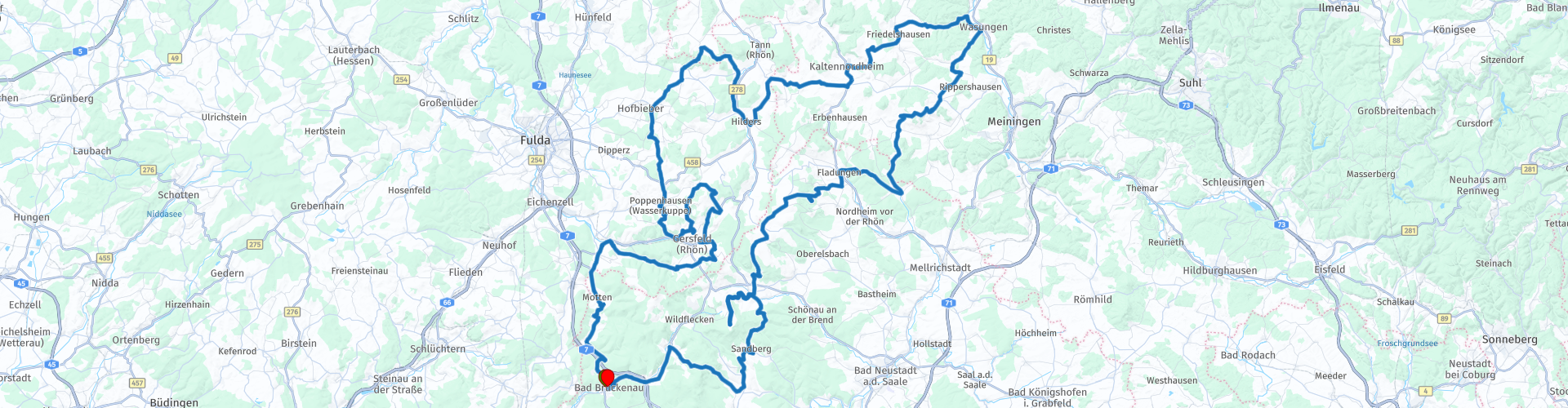
04 Rondrit Bad Bruckenau via Klosterkreuzberg en Wasserkuppe

Diese Route wurde erstellt von:
RouteXpert Leonor Orban - Sr. RouteXpert
Letzte Änderung: 25-11-2023
 Routenzusammenfassung
 Es ist eine glatte Route mit abwechslungsreicher Landschaft. Im einen Moment fahren Sie über eine Hochebene, im nächsten Moment über schöne kleine Waldwege; und dann wieder durch Täler und kleine schlafende Dörfer.
Es macht viel Spaß, besonders in Kombination mit der anderen Tagestour in dieser Routensammlung. Der Charakter dieser Route unterscheidet sich völlig von der ersten Tagestour, sodass Sie sich heute keinen Moment langweilen werden.
Die Kombination aus perfekt kurvenreichem Asphalt, leckeren Restaurants und besonderen Orten entlang der Strecke (wie dem Kreuzberg, Schloss Bieberstein und der Wasserkuppe) verleihen dieser Strecke satte 5 Sterne.
 Diese Route teilen


Animation

Urteil


Dauer
8h 42m

Reisemodus
Auto oder Motorrad

Entfernung
262.73 km

Länder

 RouteXpert-Überprüfung
 In Bad Brückenau können Sie sich weiterhin um Ihre Haushaltsangelegenheiten wie Tanken und Lebensmitteleinkauf kümmern. Von dort geht es direkt auf die Bundesstraße Richtung Riedenberg. Glücklicherweise folgt man dieser Hauptstraße nur ein kurzes Stück, bevor man fast auf einer schmalen Forststraße in das Biosphärenreservat Rhön gelangt.
Dieses Mittelgebirge mit Vulkanbergen ist bekannt für seine vielseitige Landschaft. Das merkt man heute auch beim Autofahren. Waldgebiete wechseln sich mit Wiesenlandschaften und Sumpfgebieten ab. Es gibt sogar Momente, in denen man das Gefühl hat, über eine Hochebene zu fahren.
Doch zunächst stößt man auf den Basaltsteinbruch Stangenroth. Aufgrund der vulkanischen Aktivität in dieser Region war der Boden reich an Basalt. Im 19. Jahrhundert wurden mehrere Basaltsteinbrüche angelegt, um das Gestein abzubauen. Einer der jüngsten Steinbrüche war der von Stangenroth. Dies wurde 1923 begonnen und erst 2013 eingestellt. Die Gebäude wurden abgerissen, aber der alte Steinbruch ist noch sichtbar. Es hat sich mit Wasser gefüllt und ein wunderschönes Biotop mit klarem, blauen Wasser geschaffen. Vom Parkplatz aus kann man bis zum Rand des Steinbruchs laufen. Bitte beachten Sie, dass Sie den Steinbruch nicht betreten können, da die Wände extrem steil und instabil sind. Um zu verhindern, dass (noch mehr) Menschen in den tiefen Steinbruch stürzen, hat die örtliche Regierung einen Zaun um den Rand des Steinbruchs errichtet.
Nach diesem geografischen Tiefpunkt erwartet Sie ein Höhepunkt. Über den Burgwallbacher Wald gelangen Sie zum Klosterkreuzberg. Sie erklimmen eine Höhe von etwa 850 Metern, neben der Spitze des Kreuzbergs. Hier erwartet Sie ein letzter Aufstieg zu Fuß zum Gipfel des Berges und zu den drei Kreuzen von Golgatha, die sich auf den Berg beziehen, auf dem Jesus gekreuzigt worden sein soll. Glücklicherweise muss man kein religiöser Mensch sein, um die 300 Stufen erklimmen zu wollen. Die Aussicht von der Spitze des Kreuzbergs ist wunderschön. Von hier aus hat man einen schönen Blick auf den Naturpark Rhön. Und als Belohnung nach diesem Aufstieg können Sie auf der Terrasse der Franziskanermönche Platz nehmen. Es ist ein guter Ort, hier zu sein. Das Essen ist einfach und lecker, das Bier soll himmlisch sein.
Sobald man den Kreuzberg hinabsteigt, verändert sich die Landschaft im Biosphärenreservat erneut. Diesmal scheinen Sie auf ein Plateau zu fahren. Da es nur wenige Bäume gibt, hat man auf der Hochrohnstraße das Gefühl, „über der Baumgrenze“ zu sein. Das Einzige, was Ihre Aufmerksamkeit von der Aussicht ablenkt, sind die grasenden Rhönschafe in der Wiesen- und Marschlandschaft. Dies ist eine wunderschöne Route, besonders wenn die Blumen und Pflanzen blühen. Leider ist es nicht erlaubt, am Straßenrand anzuhalten, um Fotos zu machen, aber zum Glück gibt es hier und da Wanderparkplätze, auf denen man anhalten und fotografieren kann.
Da es bei den Franziskanermönchen am Klosterkreuzberg mitunter recht voll sein kann, können Sie auch eine Pause auf der Fischerhütte am Rothsee oder der Schlossbergschänke einlegen. Die Fischerhütte ist ein uraltes kleines Restaurant an einem See oberhalb der Hochrohnstraße. Von hier aus können Sie zu einem großen alten Basaltsteinbruch laufen. Oder Sie entscheiden sich für eine „alleinstehende“ Pause an der Schlossbergschänke, etwas weiter unten am Weg, mitten im Wald.
In der Zwischenzeit schlängelt sich die Route weiter entlang wunderschöner Wiesen, gruseliger Wälder und durch schlafende Dörfer. Sie werden feststellen, dass Sie auf diesem Teil der Route auf wenige Restaurants stoßen. Aber zum Glück vergehen die Kilometer unter deinem Motor wie im Flug, sodass du gar nicht merkst, dass plötzlich fast 2 Stunden wie im Flug vergangen sind. Zeit für eine Pause im Restaurant Zur guten Quelle. Gleich nach dem Gebäude können Sie rechts in eine kleine Einfahrt einbiegen. Für einen Moment hat man den Eindruck, als würde man auf die Terrasse des Restaurants fahren, doch schon bald sieht man die Parkplätze. Bei schönem Wetter ist die Terrasse sehr zu empfehlen. Hier können Sie ein köstliches Mittagessen genießen, aber denken Sie an die deutschen Portionen. Sie werden Ihre Reise mit vollem Bauch fortsetzen!
Zeit, wieder auf die Straße zu gehen. Berücksichtigen Sie Ihren Dip nach dem Abendessen. Die Straßen schlängeln sich wunderbar durch die Landschaft und laden zum Einschlafen ein. Glücklicherweise gibt es unterwegs viel zu sehen. Zum Beispiel das Bieberstein-Palast. Dieser Palast wurde im 18. Jahrhundert im Barockstil erbaut. Es ist gut erhalten und wird heute als Internat genutzt.
Wenn Sie Ihre Beine vertreten möchten, können Sie die Steinwand besuchen. Bei einem etwa 1,5 Kilometer langen Spaziergang (ca. 30 Minuten) umrunden Sie die im Wald versteckten Basaltsäulen. An Wochenenden ist es ein beliebter Ort für Wandkletterer.
Motorradrouten sind dafür bekannt, dass sie oft nicht einer effizienten Route, sondern eher landschaftlich reizvollen Routen folgen. Dies gilt auch für diesen Streckenabschnitt. Von der Steinwand zur Wasserkuppe könnte man zwar einen schnelleren Weg nehmen, aber die schönste Route führt im Zickzack über wunderschöne Kurven zur nächsten Sehenswürdigkeit.
Die Wasserkuppe ist der höchste Berg der Rhön und hat eine reiche Geschichte. Er wird beispielsweise „Berg der Flieger“ genannt. Im Jahr 1911 wurden hier die ersten Versuche unternommen, Segelflugzeuge zu fliegen. Aufgrund der zunehmenden Beliebtheit des lautlosen Fliegens wurde 1923 ein Hangar mit einer Flugschule eröffnet. Gleichzeitig wurde eine Statue zum Gedenken an die gefallenen Flieger des Ersten Weltkriegs errichtet. Diese Statue steht noch immer stolz auf dem Berg. Nach dem Zweiten Weltkrieg richteten die Briten auf dem Berg eine Radarstation ein, die im Laufe der Jahre erweitert wurde. Sie werden sehen, dass die Radarstation und der Segelflugclub noch in Betrieb sind. Dies gilt auch für das Bergrestaurant, das hier seit 1914 betrieben wird.
Besonders am Wochenende ist dieser Berg sehr beliebt. Motorradfahrer, Wanderer und Segelflieger kommen gerne hierher. Sie haben die Wahl, ob Sie hier anhalten, sich umsehen und eine Pause einlegen möchten. Wer den Menschenmassen lieber aus dem Weg gehen möchte, sollte den Berg besser schnell verlassen. Unterwegs schwenken Sie an der Fuldaquelle vorbei, um 12 Kilometer weiter zur Berghütte Simmelsberg zu gelangen. Es ist ein Berggasthaus vom Feinsten: ein gemütlicher Biergarten mit den charakteristischen hölzernen Picknickbänken und Tischen.
Von hier aus sind es nur noch 40 Kilometer bis zu Ihrem Hotel. Genießen Sie eine Weile die kleinen Landstraßen durch die Natur. Zurück auf einer breiten Hauptstraße erreicht man den Gipfel der Mottener Höhe. Dieser 680 Meter hohe Berg markiert die Grenze zwischen der bayerischen und der hessischen Rhön. Den Berg hinunter ist ein Genuss. Über den engen Asphalt fährst du in einigen wunderschönen Kurven, bevor du wieder in Bad Brückenau ankommst. Tanken Sie einfach bei der OMV auf, bevor Sie zurück auf den Hotelparkplatz fahren.
Genießen Sie einen letzten Abend lang die Ruhe und die gesunde Luft im Spa. Morgen beginnt die eintägige Fahrt zurück in die Niederlande.


 Links
Links  Nutzung
 Möchten Sie diese Route herunterladen?
Sie können die Route ohne MyRoute-App-Konto kostenlos herunterladen. Öffnen Sie dazu die Route und klicken Sie auf 'Speichern unter'. Möchten Sie diese Route bearbeiten?
Kein Problem, starten Sie mit dem Öffnen der Route. Folgen Sie dem Tutorial und erstellen Sie Ihr persönliches MyRoute-App-Konto. Nach der Registrierung startet Ihre Testversion automatisch.  Haftungsausschluss
Die Nutzung dieser GPS-Route erfolgt auf eigene Kosten und Gefahr. Die Route wurde sorgfältig von einem MyRoute-App akkreditierten RouteXpert für die Verwendung mit TomTom, Garmin und MyRoute-App Navigation zusammengestellt und geprüft.
Durch geänderte Umstände, Straßenumleitungen oder saisonale Sperren können sich dennoch Änderungen ergeben haben. Wir empfehlen daher, jede Route vor der Nutzung zu überprüfen.
Verwenden Sie vorzugsweise den Routentrack in Ihrem Navigationssystem. Mehr Informationen zu den Die Nutzung der MyRoute-App finden Sie auf der Website unter 'Community' oder 'Academy'.