04 Hornos to Cartagena

This route was brought to you by:
RouteXpert Nick Carthew - (MRA Master)
Last edit: 04-03-2022
 Route Summary
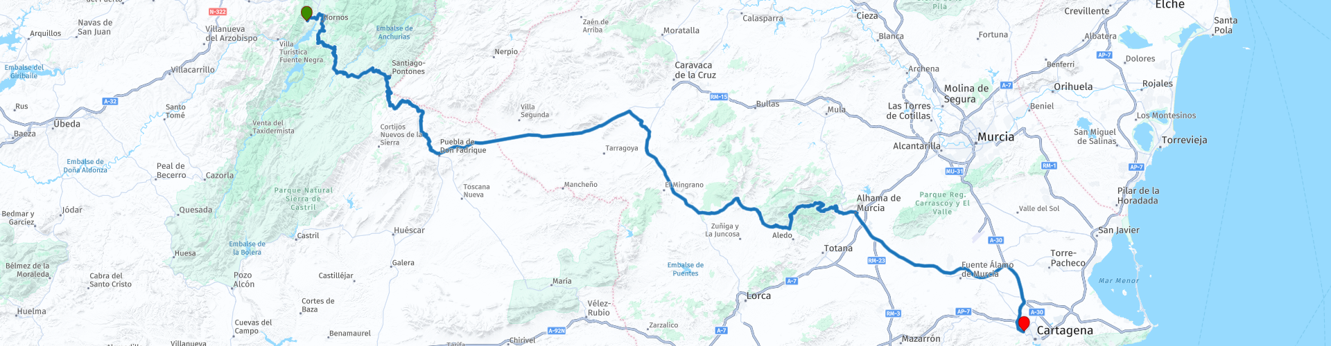
 This route travels from the simply stunning Sierras de Cazorla, Segura y Las Villas Natural Park in Andalucia on a beautiful twisty mountain road. It then uses a fast, straight road across a plateau to reach the Sierra Espuña Regional Park. Another truly beautiful landscape of hairpin bends and breathtaking views. The landscape and twisty roads earn this route 5***** stars.
 Share this route


Animation

Verdict


Duration
9h 7m

Mode of travel
Car or motorcycle

Distance
268.47 km

Countries

 RouteXpert Review
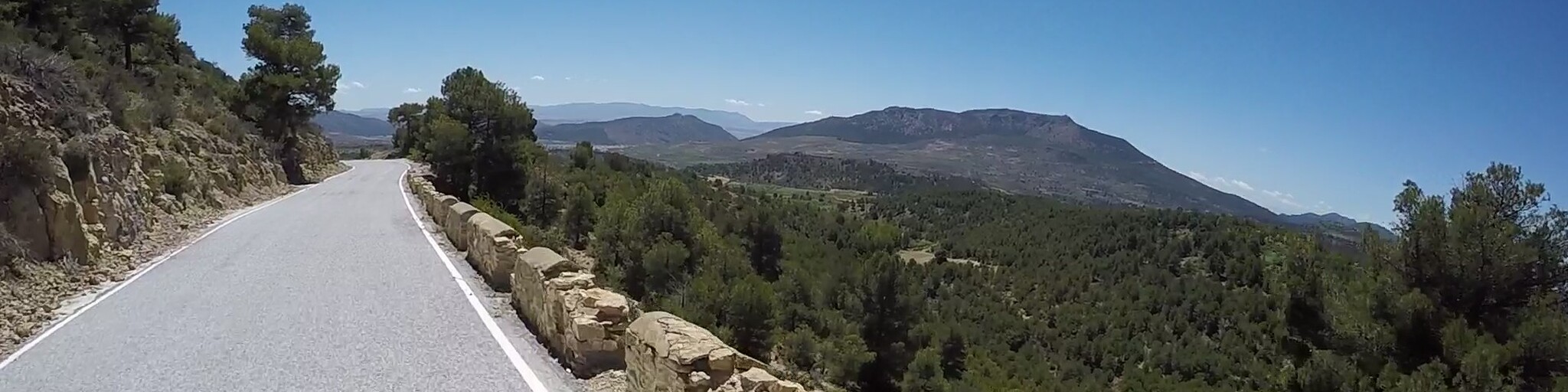
 There are many viewpoints to stop at that have stunning vistas for some great photos. The A-317 road twists and turns and climbs and falls for 45 km as you head for the small mountain village of Santiago de la Espada situated an altitude of 1,340m. We stopped here for fuel and had a coffee and snack of the most delicious Pan con Tomate at Bar Avenida. A few km south from here, the A-317 narrows and becomes even more twisty and hilly as you cross over the Rio Zumeta and enter into the province of Granada. The next 30 km will take your breath away, pine trees, twisty road that has no edge protection with a steep drop off on one side or gnarly limestone rock encroaching onto the road and the views - wow, the views that make Andalusia my favourite region.
The route gradually descends from an average altitude of about 1,500m to 1,00m as it reaches Puebla de Don Fabrique. This town is steeped in history and an abundance of ancient relics have been found there from prehistoric to medieval times. There are significant archaeological remains from the Iberian-Roman and Muslim eras, in the 13th and 14th centuries. According to historic documentation dating back to 1241, this area was once called La Bolteruela. Since this was a main regional border, there were many battles fought here between the Moors and Christians.
The route leaves the spectacular A-317 and joins the much faster A-330 that travels across a plateau taking you out of Andalucia and into Murcia. The level road is arrow straight in places, a big contrast to the 80 km from the start. An hour on from Puebla de Don Fabrique is a great roadside restaurant for lunch called Asador Murciano Restaurante, I recommend the garlic prawns and belly pork.
After lunch, a 30 minute ride takes you to the Sierra Espuña Regional Park. This beautiful regional park has an average altitude of around 800 metres with some peaks over 1,500 m. The uneven relief of the Sierra Espuña range is precisely one of its main attractions, as this is what gives it its unique and imposing landscapes. There's even a series of 18 tight hairpin bends to negotiate!
The Regional Park of Sierra Espuña is absolutely stunning covering 25,000 hectares it has been protected since 1930. Pine trees cover most of the park and the views over the top of the pine forests are magnificent. It takes its name from its highest mountain, the Espuña at 1,583 m. The park has quite an intriguing history. The region of Murcia enjoyed great prosperity during the 18th century when it plundered its natural resources including most of its pine forests. When Ricardo Codorniu, a passionate nature lover and forest engineer returned to the region in 1889, he was devastated by the destruction which the years of economic boom had caused. He set about restoring the forest, replanting some 19,000 hectares and he becoming known as the ‘apostle of trees!
As you drive through the park you’ll notice evidence of his hard work as a lot of the pine trees are planted in straight lines. The mountain road is very well maintained and there are numerous panoramic viewpoints, as well as some great picnic areas. If you’re lucky you’ll see the Moufflon mountain goats, wild boars and circling eagles during your scenic ride.
40 minutes from the park and you'll have reached the end of the route at the beautiful and historic city of Cartagena.
It’s only when you reach the old part of town down by the port, with its narrow medieval streets, packed with bars and restaurants that the city’s real character emerges. The port of Cartagena, in the Mediterranean's Costa Cálida, has been prized since Carthaginian times. Thanks to its strategic position on the Murcia coast, it has been inhabited by several cultures which have left their mark on its artistic heritage. Cartagena is a city with more than 2,500 years of history. Each corner, street and square of the city offers travellers monumental examples of its splendorous historical past and of the civilizations that put in at its port.
Enjoy


 Links
Links  Usage
Usage Want to download this route?
You can download the route for free without MyRoute-app account. To do so, open the route and click 'save as'. Want to edit this route?
No problem, start by opening the route. Follow the tutorial and create your personal MyRoute-app account. After registration, your trial starts automatically.  Disclaimer
Use of this GPS route is at your own expense and risk. The route has been carefully composed and checked by a MyRoute-app accredited RouteXpert for use on TomTom, Garmin and MyRoute-app Navigation.
Changes may nevertheless have occurred due to changed circumstances, road diversions or seasonal closures. We therefore recommend checking each route before use.
Preferably use the route track in your navigation system. More information about the use of MyRoute-app can be found on the website under 'Community' or 'Academy'.

Murcia
About this region
The Region of Murcia (, US also ; Spanish: Región de Murcia [reˈxjon de ˈmuɾθja]), is an autonomous community of Spain located in the southeast part of the Iberian Peninsula, on the Mediterranean coast. The region is centered on a historical region of the same name in what is now southeastern Spain. It is heir to the ancient Kingdom of Murcia, which traditionally included, as a bi-provincial region, the provinces of Albacete and Murcia. During the transition to democracy (la Transición), Albacete became part of Castilla–La Mancha. The region is 11,313 km2 (4,368 sq mi) in area and had a population of 1,511,251 as at the start of 2020. About one-third of its population lives in the capital, Murcia. At 2,014 m (6,608 ft), the region's highest point is Los Obispos Peak in the Massif of Revolcadores.The region is bordered by Andalusia (the provinces of Almería and Granada), Castile La Mancha (the province of Albacete, which until 1980 was a part of Murcia), the Valencian Community (province of Alicante), and the Mediterranean Sea. The autonomous community is a single province. The city of Murcia is the capital of the region and the seat of the regional government, but the legislature, known as the Regional Assembly of Murcia, is located in Cartagena. The region is subdivided into municipalities.The region is among Europe's largest producers of fruits, vegetables, and flowers, with important vineyards in the municipalities of Jumilla, Bullas, and Yecla that produce wines of Denominación de origen. It also has an important tourism sector concentrated on its Mediterranean coastline, which features the Mar Menor saltwater lagoon. Industries include the petrochemical and energy sector (centered in Cartagena) and food production. Because of Murcia's warm climate, the region's long growing season is suitable for agriculture; however, rainfall is low. As a result, in addition to the water needed for crops, there are increasing pressures related to the booming tourist industry. Water is supplied by the Segura River and, since the 1970s, by the Tagus-Segura Water Transfer, a major civil-engineering project that brings water from the Tagus River into the Segura under environmental and sustainability restraints.
Notable features of the region's extensive cultural heritage include 72 cave art ensembles, which are part of the rock art of the Iberian Mediterranean Basin, a World Heritage Site. Other culturally significant features include the Council of Wise Men of the plain of Murcia and the tamboradas (drumming processions) of Moratalla and Mula, which were declared intangible cultural heritage by UNESCO. The region is also the home of Caravaca de la Cruz, a holy city in the Catholic Church that celebrates the Perpetual Jubilee every seven years in the Santuario de la Vera Cruz.
Read more on Wikipedia
Notable features of the region's extensive cultural heritage include 72 cave art ensembles, which are part of the rock art of the Iberian Mediterranean Basin, a World Heritage Site. Other culturally significant features include the Council of Wise Men of the plain of Murcia and the tamboradas (drumming processions) of Moratalla and Mula, which were declared intangible cultural heritage by UNESCO. The region is also the home of Caravaca de la Cruz, a holy city in the Catholic Church that celebrates the Perpetual Jubilee every seven years in the Santuario de la Vera Cruz.
View region
 Statistics
  4
4Amount of RX reviews (Murcia)
 16703
16703Amount of visitors (Murcia)
 245
245Amount of downloads (Murcia)
 Route Collections in this region
 A 4 day tour in Spain from Bilbao to Cartagena
With a starting point just south of Bilbao, this 1,300 km tour is easy to connect to from the French border or Santander. The tour travels through some of Spain's most spectacular landscapes and visits among other things, the windmills of La Mancha, made famous in the books by Miguel de Cervantes and his character Don Quixote. The end of this 4 day tour is at Cartagena on the Mediterranean's Costa Cálida, a wonderful city that's alive with culture, history and gastronomy.
View Route Collection
Hasta la Vista
"Hasta la vista" is a Spanish expression that literally translates to "until we see you." It's used as a farewell greeting and means something like "see you later," "see you later," or "farewell." The routes under the Hasta la Vista umbrella all have in common that they head towards the Spanish sun, and along the way you'll encounter (almost) forgotten sights, refreshing your memories and reviving the joy of it all.
This collection consists of 16 routes that all share one thing in common: they all face south, heading towards the sunny south and then all the way to the Costa del Sol. The first route begins in the northernmost tip of the cool Netherlands near Moddergat, and the last route ends in the sunny south of Spain near Almeria.
This collection consists of 16 routes that all share one thing in common: they all face south, heading towards the sunny south and then all the way to the Costa del Sol. The first route begins in the northernmost tip of the cool Netherlands near Moddergat, and the last route ends in the sunny south of Spain near Almeria.
View Route Collection