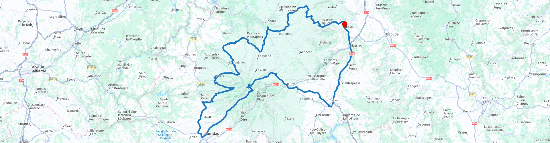
Vulcans Roundtrip from Blesle

Esta ruta fue hecha por:
RouteXpert Jan Koelstra - Senior Rx
Última edición: 18-11-2024
 Resumen de ruta
 El viaje comienza y termina en Blesle, en el corazón del parque regional "Volcanes de Auvernia".
Los caminos serpentean por las laderas con fantásticas vistas de los conos volcánicos y luego a través de las colinas pasando por pintorescos pueblos construidos con roca de lava. Esta zona también cuenta con castillos, fortalezas y fortificaciones medievales que añaden variedad. Es por eso que esta gira obtiene una calificación de cinco estrellas.
 Compartir esta ruta


Animation

Veredicto


Duración
9h 1m

Modo de viaje
Coche o motocicleta

Distancia
298.12 km

Países

 Revisión de RouteXpert
 Y para empezar por esa cultura y esa historia: en el Cantal descubrirás la Francia del pasado. El departamento cuenta con pueblos más que suficientes que merecen una visita. Consideremos, por ejemplo, el Salers medieval, con su iglesia de Saint Mathieu y sus numerosos edificios hechos de piedra de lava negra. O Saint-Flour, situada entre dos volcanes, que antiguamente era un lugar importante por su favorable ubicación en varias rutas comerciales. Tampoco deberías perderte Aurillac. La antigua capital de Alta Auvernia es una serie de sorpresas.
La ruta comienza en Blesle, donde se extraía lava solidificada como material de construcción y discurre principalmente por el parque natural regional Volcans d'Auvergne. La historia del pueblo comienza en el siglo IX con la fundación de una abadía benedictina. Es un pueblo antiguo muy bonito, uno de los pueblos más bellos de Francia. Llaman la atención las numerosas casas de viticultores, casas con entramado de madera, voladizos y dinteles con frontones en este pueblo medieval fundado en el siglo XIII. Una iglesia muy bonita con muchos tesoros, la torre del homenaje de Mercoeur que domina el pueblo, un pequeño museo de tocados, un hotel muy bonito y una cervecería artesanal que ofrece muy buenas cervezas.
A las afueras del pueblo pasará una gasolinera en la carretera de Saint-Flour.
Sobre el río Ander se alza una meseta basáltica en la que se alinean las casas de Saint-Flour. En el medio, en un barrio medieval, se encuentra la catedral de Saint-Pierre, un gótico excéntrico, porque el estilo gótico casi nunca fue aceptado en Auvernia. El palacio episcopal ha sido rediseñado cerca de la catedral. Aquí llama la atención el bonito mobiliario de la región. Junto a la catedral hay un museo con alfombras y objetos esmaltados.
Saldrá de Saint-Flour hacia el noroeste hasta el pueblo de Le Sailhant, donde definitivamente merece una visita el impresionante Château du Sailhant.
Después de Le Sailhant y Coltines llegarás a Murat para tomar un café y al centro de la ciudad...
Los tejados de Murat están cubiertos de pizarra. El pueblo está separado del pico volcánico Plomb du Cantal por un bosque. En el centro de artesanía manda la naturaleza, como lo demuestra la nutria pescadora, que se puede encontrar en el agua de numerosos arroyos. Esta naturaleza también se refleja en la Maison de la Fauna local, que exhibe una gran colección de animales, aves y mariposas. El café está listo en Murat.
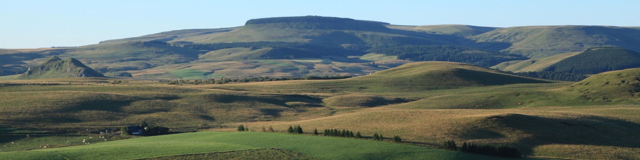
Entre Murat y Aurillac, la D680 rodea el Puy Mary a través del macizo volcánico del Cantal. En el Pas de Peyrol, una corta subida (30 minutos a pie) es suficiente para disfrutar de una de las vistas más amplias de Francia desde el Puy Mary. Todos los picos importantes están sobre una mesa de orientación. Cuando hace buen tiempo, la vista se extiende hasta 340 km hasta el Mont Blanc.
Aurillac es el centro comercial de los Monts du Cantal. En el norte de la ciudad, el complejo del castillo de Saint-Etienne alberga un museo que explica la geología de las regiones volcánicas. Por supuesto, destaca principalmente el grupo volcánico del Cantal. Vale la pena ver el centro histórico de Aurillac.
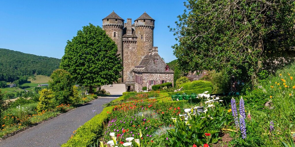
Entre Aurillac y Salers verá numerosos castillos repartidos por las laderas de Auvernia. Antes de llegar a Salers, pasará por el pueblo de Tounemire para hacer una parada para almorzar. A las afueras del pueblo se encuentra el castillo alto y cerrado de Anjony (abierto por la tarde). Louis d'Anjony, uno de los compañeros de Juana de Arco, construyó el castillo. La torre del homenaje es un ejemplo de modestas fortificaciones de montaña del siglo I. El castillo ha permanecido en posesión de la misma familia durante todos estos siglos. En el pueblo podrá saciar su hambre con vistas a la enorme estructura.
Un gran aparcamiento justo antes del pueblo ya indica que SaIers tiene un aspecto demasiado bonito para llenarlo de hojalata. La ciudad de granito tiene edificios pintorescos entre los conos volcánicos de los Montes del Cantal. La iglesia situada cerca del aparcamiento alberga un sepulcro de gran calidad del siglo I. Hay numerosos edificios renacentistas alrededor de la Grand Place y de las sinuosas calles. Algunas se pueden visitar, como la Maison du Baillage, con las dos torres de las esquinas. El paisaje urbano de SaIers surgió durante los tiempos turbulentos de la Guerra de los Cien Años, cuando la gente prefería vivir en una zona fortificada. El comercio aseguró que muchos ciudadanos pudieran construir casas tan lujosas y fortificadas.
Pequeños "burones" (cobertizos) se encuentran dispersos al pie de lo que alguna vez fue un enorme volcán y que ahora se encuentra en paz. Hace unos veinte millones de años el volcán explotó con tanta violencia que aún no se sabe con certeza dónde se encontraba el núcleo de este gigante. Es cierto que no se puede encontrar cerca de Riom-ès Montagnes, un pueblo relativamente bajo que se encuentra en una zona quesera y con un mercado de ganado. Al entrar en la Maison de la Gentiane, se inicia en el mundo de las plantas medicinales que prosperan en suelos volcánicos, como la genciana. Se cosecha por sus raíces. El sitio tiene una notable iglesia del siglo XI a la que se le añadió un campanario más tarde.
Se sale de Riom en dirección este hacia los Monts du Cézallier. Via Lugarde, donde podrás hacer una pausa para dar un paseo en tren con el Gentiana Express o con el Vélorail du Cézallier en dirección a Saint Saturnin.
Más adelante, en Feniers, encontrarás un antiguo monasterio cisterciense, fundado en el siglo XII. La abadía de Feniers de Condat, en Cantal, está hoy en ruinas. Catalogado como Grado II, fue completamente reconstruido después de un incendio a finales del siglo XVII, antes de ser destruido nuevamente y servir de cantera para las casas vecinas. Originariamente, la Abadía de Feniers estaba formada por una iglesia con columnas con capiteles que sustentaban las bóvedas románicas. Los edificios constaban de una fachada y dos alas paralelas que rodeaban una torre cuadrada.
A través de los Montes del Cézallier regresamos a Blesle. Las vistas y la belleza natural en particular ocupan un lugar central aquí. También se ven burones repartidos por todo el país para resguardarse del mal tiempo. En Blesle es agradable tomar una copa después en el Bistrot de le Tour o en Bougnate.

 Enlaces
  Uso
Uso ¿Quiere descargar esta ruta?
Puede descargar la ruta gratis sin la cuenta de MyRoute-app. Para hacerlo, abra la ruta y haga clic en 'guardar como'. ¿Quiere editar esta ruta?
No hay problema, comience abriendo la ruta. Siga el tutorial y cree su cuenta personal de MyRoute-app. Después de registrarse, su prueba comienza automáticamente.  Descargo de responsabilidad
El uso de esta ruta GPS es por su cuenta y riesgo. La ruta ha sido cuidadosamente compuesta y verificada por un RouteXpert acreditado por MyRoute-app para su uso en TomTom, Garmin y MyRoute-app Navigation.
No obstante, es posible que se hayan producido cambios debido a circunstancias cambiantes, desvíos de carreteras o cierres estacionales. Por lo tanto, recomendamos comprobar cada ruta antes de utilizarla.
Utilice preferentemente el track de ruta en su sistema de navegación. Más información sobre el el uso de la aplicación MyRoute se puede encontrar en el sitio web en 'Comunidad' o 'Academia'.

Auvergne Rhone Alpes
Acerca de esta región
Auvernia-Ródano-Alpes (en francés, Auvergne-Rhône-Alpes; en occitano Auvèrnhe Ròse Aups; en francoprovenzal Ôvèrgne Rôno-Arpes) es una de las trece regiones que, junto con los territorios de Ultramar, conforman la República Francesa. Su capital y ciudad más poblada es Lyon.
Está ubicada al sudeste del país, limitando al noroeste con Centro-Valle del Loira, al norte con Borgoña-Franco Condado, al noreste con Suiza, al este con Italia, al sur con Provenza-Alpes-Costa Azul y Occitania, y al oeste con Nueva Aquitania. Con 69 711 km² es la tercera región más extensa —por detrás de Nueva Aquitania y Occitania— y con 7 634 000 habitantes en 2012, la segunda más poblada, por detrás de Isla de Francia.
Se creó por la reforma territorial de 2014 fusionándose Auvernia y Ródano-Alpes, y entró en vigor el 1 de enero de 2016.[1]
Se compone de 12 departamentos y una metrópoli con estatus de colectividad territorial.[2]
Leer más en Wikipedia
Está ubicada al sudeste del país, limitando al noroeste con Centro-Valle del Loira, al norte con Borgoña-Franco Condado, al noreste con Suiza, al este con Italia, al sur con Provenza-Alpes-Costa Azul y Occitania, y al oeste con Nueva Aquitania. Con 69 711 km² es la tercera región más extensa —por detrás de Nueva Aquitania y Occitania— y con 7 634 000 habitantes en 2012, la segunda más poblada, por detrás de Isla de Francia.
Se creó por la reforma territorial de 2014 fusionándose Auvernia y Ródano-Alpes, y entró en vigor el 1 de enero de 2016.[1]
Se compone de 12 departamentos y una metrópoli con estatus de colectividad territorial.[2]
Ver región
 Estadísticas
  129
129Cantidad de revisiones de RX (Auvergne Rhone Alpes)
 57078
57078Cantidad de visitantes (Auvergne Rhone Alpes)
 7123
7123Cantidad de descargas (Auvergne Rhone Alpes)
 Ruta de colecciones en esta región
 Las 24 rutas alpinas más bellas
Los Alpes, Los Alpes son una cadena montañosa en Europa, que se extiende desde la costa mediterránea francesa en el suroeste hasta la llanura de Panonia en el este. El área de la cordillera es de más de 200.000 km².
En otras palabras, ¡Pasos y caminos de montaña!
¡Conducir por las montañas es genial! Especialmente en los puertos de montaña con curvas cerradas y carreteras estrechas y sinuosas. Cada curva una vista diferente donde poder disfrutar. Hay muchos puertos de montaña hermosos en los Alpes.
Una selección que también se ha incorporado a estas rutas:
El paso de Stlevio:
El paso Stelvio, también conocido como Passo dello Stelvio, es principalmente conocido por la etapa en el Giro d'Italia. Debido a la longitud y la diferencia de altura, este pase se considera una de las pruebas más duras del ciclismo. El paso Stelvio alcanza una altura máxima de 2758 metros y, por tanto, es uno de los más altos de los Alpes. El paso conecta las localidades de Bormio y Prato Allo Stelvio. En invierno, el paso está cerrado debido a las fuertes nevadas.
El Reschenpass:
El Reschenpass, también conocido como Passo di Resia, conecta el estado austriaco de Tirol con la provincia italiana de Tirol del Sur. El paso alcanza una altura máxima de 1.504 metros y ha sido una de las conexiones norte-sur más importantes de los Alpes en los últimos siglos. El paso se utilizó mucho antes de la época romana. En el camino pasará por varios lugares destacados y reliquias históricas. Uno de los aspectos más destacados es el Reschensee. Este lago fue creado después de la construcción de la presa y ha sumergido completamente el pueblo de Graun. Lo único que recuerda eso es la torre del reloj en medio del lago.
Col du Galibier:
El puerto de montaña francés Col du Galibier conecta las ciudades de Saint-Michel-de-Maurienne y Briançon a través del Col du Lautaret en el sur y el Col du Télégraphe en el norte. El puerto de montaña forma parte del Tour de Francia y es muy temido, debido a que solo se puede llegar a través de los otros dos puertos de montaña. El paso alcanza una altura máxima de 2646 metros. Desde allí se puede dar un paseo hasta el mirador a 2704 metros. Aquí se pueden admirar los picos del Grand Galibier, el Mont Blanc y La Meije.
La carretera alpina de Grossglockner:
Con una altura de 3798 metros, el Grossglockner es la montaña más alta de Austria. Para disfrutar plenamente de esta impresionante montaña, puede conducir por la carretera alpina de Grossglockner y el paso que la acompaña. La ruta comienza en Bruck am Grossglockner y termina en Heiligenblut. Por supuesto, puede conducir en dos direcciones. El paso alcanza una altura máxima de 2504 metros y está cerrado en invierno debido a las fuertes nevadas. En el camino se pasan varias paradas con actividades divertidas, puntos de información, refugios de montaña y miradores. Se recomienda una visita al glaciar Kaiser-Franz-Josefs-Höhe y Pasterzen.
El Col d'Izoard:
Al igual que el Col du Galibier, el Col d'Izoard también forma parte de una etapa del Tour de Francia. El puerto de montaña conecta Briançon con el valle del río Guil. El paso se encuentra en parte en el Parque Natural Regional du Queyras y alcanza una altura máxima de 2360 metros. Lo que tiene de especial el Col d'Izoard es el paisaje árido y rocoso. ¡A veces se siente como conducir un coche por la luna! En el camino puede detenerse en varios puntos para disfrutar de la hermosa vista.
El pase Bernina:
El Bernina Express es uno de los trenes ferroviarios más famosos de Suiza y los Alpes. La ruta es hermosa y en parte está incluida en la Lista del Patrimonio Mundial de la UNESCO. Paralelo al ferrocarril se encuentra el paso de Bernina, que conecta el valle de Veltlin con el valle de Egandin. Esta hermosa carretera alpina tiene una longitud total de 56 kilómetros y alcanza una altura máxima de 2328 metros. En el camino podrá disfrutar de las vistas del glaciar Morteratsch.
El paso de Sella:
El paso de Sella, también conocido como Passo di Sella, te lleva a una de las cadenas montañosas más impresionantes de los Dolomitas: el macizo de Sella. El paso conecta Valle di Fassa con Val Gardena y alcanza una altura máxima de 2236 metros. A esta altura también se encuentra la frontera de las provincias italianas de Trentino y Bolzano. En el camino podrá disfrutar de la vista de este espectacular mundo montañoso. Admire, por ejemplo, los tres picos del macizo Sasso Lungo, el macizo del Sella o los picos de la Marmolada. También puede conducir el pase Sella en combinación con el pase Gardena, el pase Pordoi y el pase Campolongo.
El paso de Grimsel:
El paso de Grimsel conecta Goms en Wallis con el valle de Halis en el Oberland bernés. El paso alcanza una altura máxima de 2165 metros y está cerrado en invierno por nevadas. A lo largo de los siglos, el paso de montaña ha jugado un papel importante en el comercio entre Suiza e Italia. Ahora son principalmente los embalses los que tienen una función importante. Estos se utilizan para generar electricidad. El paisaje que atraviesa es accidentado, rocoso e impresionante. En la parte superior del pase hay un hotel y un restaurante con un parque especial de marmotas. El Dodensee (Totensee) también se encuentra aquí. Este lago debe su nombre a los numerosos soldados que murieron en la época de Napoleón.
El paso de San Gotardo:
El paso de San Gotardo, también conocido como Passo del San Gottardo y Saint Gotthard, conecta las ciudades suizas de Airolo y Andermatt. El paso de montaña y el túnel asociado son especialmente conocidos entre los turistas que conducen desde Suiza a Italia. Pero donde la mayoría opta por el túnel, es precisamente el paso el que realmente completa las vacaciones. El paso de San Gotardo tiene una longitud de unos 26 kilómetros y alcanza una altura máxima de 2106 metros. La ruta es hermosa y te lleva por pueblos antiguos y hermosas vistas.
La carretera alpina de Silvretta y el paso de Silvretta:
El valle de Paznaun en el Tirol y el Montafon en Vorarlberg están conectados por la carretera alpina de Silvretta. La ruta tiene una longitud de 22,3 kilómetros y conduce de Galtür a Partenen en 34 curvas cerradas, a través de Bielerhöhe de 2.032 metros de altura. El Silvrettasee también se encuentra en este punto, donde se puede disfrutar de un agradable paseo. El paso está cerrado en invierno por nevadas.
El pase de Simplon:
Al igual que el Gotthard Pass, muchos turistas también viajan por el Simplon Pass todos los años. Este paso de montaña conecta el valle del Ródano en el cantón de Valais con el Valle d'Ossola en Piemonte. El paso está abierto todo el año y alcanza una altura máxima de 2005 metros. En el camino se pasa por varios edificios, incluido el conocido Simplon Hospiz de 1825. El hospiz está dirigido por los monjes de San Bernardo. Desde el punto más alto del puerto son posibles todo tipo de rutas de senderismo y también te encontrarás con un hotel donde pasar la noche.
El paso de Gerlos:
El paso de Gerlos conecta el valle de Salzach en la región de Salzburgo con el valle de Zillertal en el Tirol. El pase forma parte de Gerlos Alpenstraße y atraviesa el Parque Nacional Hohe Tauern. En el camino podrá disfrutar de hermosas vistas de los alrededores. El paso tiene una longitud de 12 kilómetros y alcanza una altura máxima de 1531 metros. Un paseo por el paso de Gerlos se puede combinar idealmente con una visita a Krimmler Wasserfälle.
El paso del Gran San Bernardo:
El Gran Paso de San Bernardo, más conocido como Col du Grand Saint Bernard, conecta la provincia italiana del Valle de Aosta con el cantón suizo de Valais. El paso es uno de los más altos de Suiza y alcanza una altura máxima de 2469 metros. Al igual que otros puertos de montaña de esta lista, el Gran Paso de San Bernardo también se ha utilizado como carretera de conexión durante siglos. El paso lleva el nombre de los perros San Bernardo que solían ayudar a los viajeros varados junto con los monjes. El paso está cerrado en invierno.
La carretera alpina de Timmelsjoch:
La carretera alpina de Timmelsjoch conecta las ciudades de Sölden en Ötztal y Meran en Tirol del Sur. Los peajes deben pagarse en la ruta Hochgurgl - Moos. A través de una carretera de montaña con unas 60 curvas cerradas, atraviesa un hermoso mundo montañoso. Con la experiencia Timmelsjoch puede aprender más sobre la historia, la carretera y el medio ambiente a través de varias estaciones. También puede visitar el museo Top Mountain Crosspoint.
Col de l'Iseran:
Con una altura máxima de paso de 2770 metros, el Col l'Iséran es uno de los puertos de montaña más altos de los Alpes. El paso conecta Bourg-Saint-Maurice con Bonneval-sur-Arc. A través de una carretera llena de curvas cerradas se pasa, entre otras cosas, Val-d'Isère y un valle lateral del Maurienne que se encuentra en su totalidad en el Parque Nacional de la Vanoise. Puede observar animales como marmotas y rebecos y también hay un restaurante con una capilla en la parte superior del paso.
El paso de Gavia:
El paso de Gavia (Passo di Gavia italiano) es un paso de montaña en los Alpes italianos, en la región de Lombardía.
Es una de las carreteras de paso más altas de Europa. El camino atraviesa el Parque Nacional Stelvio virgen. La carretera fue construida en la Primera Guerra Mundial para abastecer a los soldados italianos que lucharon en la zona fronteriza entre Italia y Austria. La altura del paso es una de las más hermosas de los Alpes. Aquí está el gran Lago Bianco con, al norte, la montaña San Matteo (3684 metros). Lago Nero es un poco más bajo en el lado sur del paso. Aquí el grupo montañoso del Adamello determina la vista. Hay muchos paseos bien señalizados en la zona. Durante el invierno, el paso está cerrado debido a las fuertes nevadas. El paso suele estar cerrado hasta mayo y junio debido a la gran cantidad de nieve.
Promotor ha realizado una selección de las 24 rutas alpinas más bonitas que se han planteado en los últimos años.
Las rutas pasan por:
Francia
Austria
Suiza
Italia
Los caminos más bonitos, las vistas más bonitas, los miradores más bonitos. Las montañas más altas, los descensos más rápidos, curva cerrada tras curva cerrada, lo que sea, no se puede tener suficiente.
Si te vas de vacaciones a esta región, aprovéchalo, TODAS las rutas de esta colección se han verificado y se han igualado para TomTom, Garmin y MyRoute-app Navigation mediante una MyRoute-app RouteXpert.
Diviértete con esta colección y mientras conduces por una de estas rutas. Disfrute de toda la belleza que ofrecen los Alpes y los Dolomitas. Haga clic en "Ver ruta" para leer la reseña de la ruta elegida.
Me gustaría escuchar sus hallazgos sobre la (s) ruta (s).
Ver colección de rutas
25 magníficos senderos en Francia
Esta colección de rutas MRA contiene 25 hermosas rutas en moto en diferentes partes de Francia, como las Ardenas, Alsacia, Vercors, Drôme, Ardèche, Cote d'Azure, Gorges du Verdon, Ariège, Dordoña y Bretaña.
Las rutas han sido cuidadosamente creadas por Bert Loorbach, quien es un motociclista entusiasta. Vivió en Francia durante un año y medio, tiempo durante el cual se dedicó a trazar mapas de las desconocidas y hermosas carreteras secundarias de Francia, especialmente para los motociclistas.
Las rutas están agrupadas en Motortourgids France parte 1 de la editorial Kosmos y ahora también están disponibles en MyRouteApp.
Me he hecho cargo de las rutas en MRA y, a veces, las he ajustado ligeramente para hacerlas aún más interesantes para el motociclista.
Ver colección de rutas