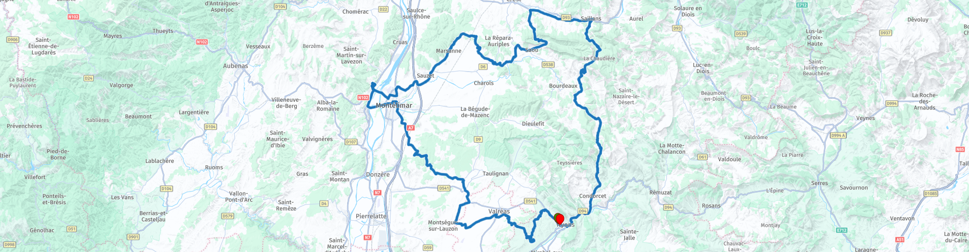
Roundtrip Nyons to Nyons passing Montelimar and the Saou Forest

Questo percorso è stato creato da:
RouteXpert Catherine De Groote RouteXpert
Ultima modifica: 27-11-2021
 Riepilogo percorso
 Con i castelli di Grignan, Montélimar e Rochemaure si ottiene un pezzo di storia e cultura in questo viaggio. La foresta di Saoû con la ripida scogliera di La Roche Colombe e Les Trois Becs ospita una variegata biodiversità. Con le profonde gole del Pas de Lauzens e delle Gorges des Trente Pas, ottieni alcune strade spettacolari spinte sotto le ruote. Questo giro vario con belle strade ottiene 5 stelle.
 Condividi questo percorso


Animation

Verdetto


Durata
10h 26m

Modalità di viaggio
Auto o moto

Distanza
218.55 km

Paesi

 Revisione RouteXpert
 Il castello, costruito su una roccia, domina il paese. Testimone dell'architettura rinascimentale e del classicismo francese, questo edificio ha avuto una storia movimentata. Il castello fortificato dell'XI secolo fu trasformato durante il Rinascimento in una prestigiosa residenza di villeggiatura. Nel XVII secolo, la marchesa di Sévigné soggiornò con sua figlia Françoise-Marguerite, divenuta contessa di Grignan grazie al suo matrimonio. Il castello fu smantellato durante la Rivoluzione francese e poi ricostruito all'inizio del XX secolo. Dal 1979 appartiene al Dipartimento della Drôme, che continua il suo ambizioso programma di ristrutturazioni e acquisizioni. Elencato nel 1993, il monumento storico offre ai suoi visitatori preziose testimonianze dell'arte di vivere in diverse epoche.
Dalle terrazze si gode di un panorama mozzafiato a 360° della Provenza e della sua lavanda, del Mont Ventoux e del villaggio di Grignan, un patrimonio notevole.
Quando si lascia Grignan, continuare a seguire la corsia di sinistra fino alla D4. Tomtom fornisce una piccola deviazione qui.
Réauville, città reale, così chiamata dal fratello di Luigi IX. Pochi secoli dopo, il paese sarà la culla della famiglia del Presidente della Repubblica Emile Loubet (1899).
Alcune case del XV secolo hanno conservato un'architettura notevole, come la casa "sopra l'arco". Sulla facciata si nota un'arma scolpita che doveva appartenere all'abbazia di Aiguebelle. Il villaggio ha una ricca storia tra cui la casa dove visse il capitano imperiale Louis Portalier, così come la casa dove nacque il primo soldato in Francia, Albert Roche (1895-1939).
Rocher de la Vierge è un luogo unico. La roccia, sulla quale nel 1856 fu eretta una statua della Vergine, troneggia sul paese. Hai una vista impressionante delle 14 città del cantone di Grignan, le montagne di La Lance, Vercors, Ardèche, Mont Ventoux, le Dentelles de Montmirail, la torre di Chamaret e il castello del conte di Grignan.
Montélimar è anche conosciuta come la "Porta della Provenza". La città si trova nel mezzo della valle del Rodano. Gli scavi mostrano che l'area intorno a questo luogo era abitata molto presto nella storia. Sono state scavate selci che si ritiene risalgano al 50.000 aC. Durante il periodo dell'Impero Romano, la città era considerata molto importante. Probabilmente ciò era dovuto al fatto che la città si trovava sulla cosiddetta Via Agrippa. Questa era una rete di strade romane nella Gallia romana, fondata da Agrippa, un generale romano. I romani ampliarono la città con diversi edifici, come un foro, un tempio e diversi bagni pubblici. Inoltre, furono costruiti acquedotti per rifornire d'acqua la città. Poco si sa di Montélimar durante il Medioevo. Per quanto ne sappiamo, la regione intorno alla città è passata di mano più volte. Oggi questa città è conosciuta in tutto il mondo come la città del torrone. Questa prelibatezza proviene originariamente da questa zona.
Château des Adhemars è un palazzo medievale, situato sulle alture di Montélimar. Testimonia il potere della famiglia Adhémar che ha dato il nome alla città. Un vero gioiello dell'architettura romanica meridionale. Dalla passeggiata a terra si ha una vista panoramica a 360° mozzafiato. I suoi vantaggi strategici sono evidenti, essendo vicino alle principali vie di comunicazione del Rodano e alla strada da Lione ad Arles. Ai margini dei regni di Borgogna e Provenza, al crocevia di potenti diocesi, questa posizione favoriva l'autonomia di questi signori, membri di un prestigioso lignaggio in Provenza e del Delfinato e i cui rappresentanti erano diversi signori di Montélimar. Il sito è costituito da una dimora signorile, una cappella romanica, una torre quadrata e un recinto fortificato sormontato da un camminamento. Nel corso dei secoli gli edifici hanno avuto molteplici funzioni. Oggi puoi scoprire il castello e la sua storia attraverso attività familiari e divertenti, immergendoti nel cuore del Medioevo.
Lasciando la città, attraverserai prima il canale di tangenziale del Rodano e poi proseguirai sul Rodano stesso. Il canale di bypass è di 14,5 km, inizia a Meysse e termina a Châteauneuf-du-Rhône.
Il Rodano nasce dal ghiacciaio del Rodano al Passo della Furka a nord-est del cantone svizzero del Vallese e da lì scorre in direzione sud-ovest. Il Rodano sfocia nel Lago di Ginevra e lascia il lago per attraversare il confine con la Francia qualche chilometro più a sud-ovest. A Lione, la Saona si unisce al fiume e il Rodano scorre definitivamente più a sud. Prima di Arles, il fiume si divide nel Grand-Rhône e nel Petit-Rhône. Questa zona è chiamata Camargue. Il Rodano sfocia nel Golfe du Lion.
Il castello di Rochemaure fu costruito tra il 1120 e il 1140. All'interno delle doppie mura si trovano un mastio e una casa padronale del XIII secolo. La location è stata scelta da un punto di vista strategico. Dalla roccia basaltica si poteva tenere d'occhio la valle del Rodano, importante per il commercio. Il castello divenne uno dei castelli più importanti della regione. Pertanto, è stato ulteriormente ampliato con ulteriori mura difensive. Nel corso dei secoli, il castello di Rochemaure passò di mano regolarmente. Fu abitato fino al 1630, ma poi cadde in rovina. Nel 1924 è stato riconosciuto come monumento storico, il che ha significato il salvataggio del castello un tempo importante. Grazie alla sua posizione, su un'alta roccia basaltica, si gode di un bellissimo panorama della zona. Diverse parti del castello sono state restaurate, in modo che durante la visita si possa avere una buona idea di come doveva apparire questo castello nel suo periodo di massimo splendore.
Potrete gustare un delizioso pasto sulla splendida terrazza sotto i platani del ristorante L'Auberge a Rochmaure.
Chi ama i dolci - o è alla ricerca di un dolce regalo - dovrebbe assolutamente visitare il Palais des Bonbons, du Nougat et des Souvenirs. Questo è uno dei siti turistici più visitati della Drôme, con quasi 150.000 visitatori all'anno. Scoprirai un intero mondo di dolci dove si mescolano zucchero, caramelle, cioccolato e il famoso torrone di Montélimar.
I 5 sensi vengono utilizzati attraverso un percorso divertente e interattivo. Proiezioni di film, organi profumati, opere uniche, espositori di caramelle e una distilleria di limonata degli anni '20 risvegliano le papille gustative di grandi e piccini.
Ora guidi più avanti e attraverso la foresta di Saoû, una delle più belle foreste della Drôme. Una vera parete calcarea si estende per oltre 2500 ettari e ospita una biodiversità eccezionale.
All'inizio di questa zona si ha una bella vista sulla ripida falesia di La Roche Colombe (886 m).
A Sao puoi fare una pausa per un drink sulla terrazza del ristorante L'Oiseau sur la Branche. Si trova su una piccola piazza dove c'è anche un parcheggio.
Seguirai quindi lo spettacolare Pas de Lauzens, indicato come "Route remarquable". È una strada abbastanza stretta attraverso gole profonde.
Il punto più alto della foresta è Les Trois Becs. È la sinclinale d'alta quota più bella d'Europa. (Una sinclinale è una piega in uno strato roccioso, in cui il materiale all'interno della piega è più giovane di quello all'esterno.)
Questo sito eccezionale ospita centinaia di specie con una diversità vegetale di influenze montane e mediterranee e una fauna selvatica molto diversificata (camoscio, capriolo, marmotta, aquila reale ...).
Il Col de la Chaudière è un passo di montagna a 1.047 m di altitudine. Il passo è lungo 22,5 km e corre da nord a sud da Saillans a Bourdeaux. La strada è stretta, ripida ma poco trafficata. Puoi aspettarti molti tornanti con splendidi panorami.
Il Belvédère du Bézaudun offre una splendida vista sui dintorni.
Gorges de Trente-Pas è una spettacolare gola scavata nel calcare. Le gole sono attraversate dai meandri della D70. La strada serpeggia come un fiume. È una strada pittoresca ma stretta con poco traffico. Nella stretta gola ci sono trenta guadi - da qui il nome. Dai resti di un villaggio con capanne risalenti all'825 aC, sappiamo che è stato abitato fin dall'epoca gallo-romana.
Il villaggio di Saint-Ferréol-Trente-Pas è noto per il suo allevamento di capre, la produzione di olive o la sua lavanda. Questa strada è una delle più famose "strade del balcone" del paese. Una strada balcone è una pista da far rizzare i capelli scavata nei lati di scogliere a picco.
Durante gli ultimi 10 km seguite gli Eygues. Il nome deriva dall'occitano 'aiga' o dal provenzale 'aïgo' che significa 'acqua'. Il fiume sfocia nel Rodano vicino a Orange.
Raggiungi la fine di questo percorso nell'accogliente Nyons. Potete eventualmente gustarlo su una delle tante terrazze.


 Collegamenti
  Utilizzo
 Vuoi scaricare questo percorso?
Puoi scaricare il percorso gratuitamente senza un account MyRoute-app. Per farlo, apri il percorso e fai clic su 'Salva con nome'. Vuoi modificare questa rotta?
Nessun problema, inizia aprendo il percorso. Segui il tutorial e crea il tuo account MyRoute-app personale. Dopo la registrazione, la tua prova inizia automaticamente.  Disclaimer
L'utilizzo di questo percorso GPS è a tue spese e rischio. Il percorso è stato accuratamente composto e controllato da un RouteXpert accreditato dall'app MyRoute per l'utilizzo su TomTom, Garmin e navigazione dell'app MyRoute.
Ciononostante potrebbero essersi verificati cambiamenti a causa di mutate circostanze, deviazioni stradali o chiusure stagionali. Si consiglia pertanto di controllare ciascun percorso prima dell'uso.
Utilizzare preferibilmente la tracklog del percorso nel sistema di navigazione. Maggiori informazioni sul l'uso dell'app MyRoute può essere trovato sul sito Web in 'Community' o 'Academy'.

Auvergne Rhone Alpes
Informazioni su questa regione
L'Alvernia-Rodano-Alpi (in francese Auvergne Rhône-Alpes, in occitano Auvèrnhe Ròse Aups, in francoprovenzale Ôvèrgne-Rôno-Arpes) è una delle regioni della Francia.
Istituita nel 2016 in seguito alla riforma territoriale del 2014 aggregando le precedenti regioni Alvernia e Rodano-Alpi ed assumendo provvisoriamente il nome attuale, divenuto poi definitivo il 30 settembre 2016, è suddivisa in dodici dipartimenti più la metropoli del suo capoluogo, Lione, con altre città principali della regione che sono Saint-Étienne, Grenoble, Villeurbanne e Clermont-Ferrand.
Composta dai dipartimenti di Ain (01), Allier (03), Ardèche (07), Cantal (15), Drôme (26), Isère (38), Loira (42), Alta Loira (43), Puy-de-Dôme (63), Rodano (69), Savoia (73) e Alta Savoia (74), sono inclusi nella regione 242 cantoni e 4189 comuni ed è la seconda regione francese per importanza in termini di PIL.
Leggi di più su Wikipedia
Istituita nel 2016 in seguito alla riforma territoriale del 2014 aggregando le precedenti regioni Alvernia e Rodano-Alpi ed assumendo provvisoriamente il nome attuale, divenuto poi definitivo il 30 settembre 2016, è suddivisa in dodici dipartimenti più la metropoli del suo capoluogo, Lione, con altre città principali della regione che sono Saint-Étienne, Grenoble, Villeurbanne e Clermont-Ferrand.
Composta dai dipartimenti di Ain (01), Allier (03), Ardèche (07), Cantal (15), Drôme (26), Isère (38), Loira (42), Alta Loira (43), Puy-de-Dôme (63), Rodano (69), Savoia (73) e Alta Savoia (74), sono inclusi nella regione 242 cantoni e 4189 comuni ed è la seconda regione francese per importanza in termini di PIL.
Visualizza regione
 Statistiche
  129
129Quantità di recensioni RX (Auvergne Rhone Alpes)
 57079
57079Quantità di visitatori (Auvergne Rhone Alpes)
 7123
7123Quantità di download (Auvergne Rhone Alpes)
 Indirizza le collezioni in questa regione
 Le 24 vie alpine più belle
Le Alpi Le Alpi sono una catena montuosa in Europa, che si estende dalla costa mediterranea francese a sud-ovest alla pianura pannonica a est. L'area della catena montuosa è più di 200.000 km².
In altre parole Passi e Strade di Montagna!
Guidare attraverso le montagne è fantastico! Soprattutto sui passi di montagna con tornanti e strade strette e tortuose. Ad ogni curva un panorama diverso da cui godere. Ci sono molti bei passi di montagna nelle Alpi.
Una selezione che è stata inserita anche in questi percorsi:
Il Passo dello Stlevio:
Il Passo dello Stelvio, noto anche come Passo dello Stelvio, è conosciuto principalmente per la tappa del Giro d'Italia. A causa della lunghezza e del dislivello, questo passaggio è considerato uno dei test più duri del ciclismo. Il Passo dello Stelvio raggiunge un'altezza massima di 2758 metri ed è quindi uno dei più alti delle Alpi. Il passo collega i comuni di Bormio e Prato Allo Stelvio. In inverno il passo è chiuso per abbondanti nevicate.
Il Passo Resia:
Il Passo Resia, noto anche come Passo di Resia, collega lo stato austriaco del Tirolo con la provincia italiana dell'Alto Adige. Il passo raggiunge un'altezza massima di 1.504 metri ed è stato uno dei più importanti collegamenti nord-sud delle Alpi negli ultimi secoli. Il passo era utilizzato molto prima dell'epoca romana. Lungo la strada passerai diversi punti salienti e cimeli storici. Uno dei punti forti è il Lago di Resia. Questo lago è stato creato dopo la costruzione della diga e ha completamente sommerso il paese di Graun. L'unica cosa che lo ricorda è la torre dell'orologio in mezzo al lago.
Col du Galibier:
Il passo di montagna francese Col du Galibier collega le città di Saint-Michel-de-Maurienne e Briançon tramite il Col du Lautaret a sud e il Col du Télégraphe a nord. Il valico fa parte del Tour de France ed è molto temuto, in quanto raggiungibile solo attraverso gli altri due passi alpini. Il passo raggiunge un'altezza massima di 2646 metri. Da lì puoi fare una passeggiata fino al punto panoramico a 2704 metri. Qui puoi ammirare le vette del Grand Galibier, del Monte Bianco e della Meije.
La Strada alpina del Grossglockner:
Con un'altezza di 3798 metri il Grossglockner è la montagna più alta dell'Austria. Per godere appieno di questa imponente montagna, è possibile percorrere la Strada alpina del Grossglockner e il passo di accompagnamento. Il percorso parte da Bruck am Grossglockner e termina a Heiligenblut. Ovviamente puoi guidare in due direzioni. Il passo raggiunge un'altezza massima di 2504 metri ed è chiuso in inverno a causa di abbondanti nevicate. Lungo il percorso si superano diverse soste con attività ludiche, punti informativi, rifugi e punti panoramici. Si consiglia vivamente una visita al ghiacciaio Kaiser-Franz-Josefs-Höhe e Pasterzen.
Il Col d'Izoard:
Come il Col du Galibier, anche il Col d'Izoard fa parte di una tappa del Tour de France. Il valico collega Briançon con la valle del fiume Guil. Il passo si trova in parte nel Parco Naturale Regionale del Queyras e raggiunge un'altezza massima di 2360 metri. La particolarità del Col d'Izoard è il paesaggio arido e roccioso. A volte sembra di guidare un'auto sulla luna! Lungo il percorso è possibile sostare in più punti per godere del bellissimo panorama.
Il Passo del Bernina:
Il Bernina Express è uno dei treni ferroviari più famosi della Svizzera e delle Alpi. Il percorso è bellissimo e in parte inserito nella World Heritage List dell'UNESCO. Parallelo alla ferrovia si trova il passo del Bernina, che collega la Val Veltlin con la Val d'Egandin. Questa bellissima strada alpina ha una lunghezza totale di 56 chilometri e raggiunge un'altezza massima di 2328 metri. Lungo il percorso si può godere della vista sul ghiacciaio del Morteratsch.
Il Passo Sella:
Il Passo Sella, detto anche Passo di Sella, porta su uno dei gruppi montuosi più imponenti delle Dolomiti: il massiccio del Sella. Il passo collega la Valle di Fassa con la Val Gardena e raggiunge un'altezza massima di 2236 metri. A questa altezza si trova anche il confine delle province italiane del Trentino e di Bolzano. Lungo il percorso si può godere della vista di questo spettacolare mondo alpino. Ammirate, ad esempio, le tre cime del massiccio del Sasso Lungo, il massiccio del Sella o le vette della Marmolada. Si può percorrere anche il passo Sella in abbinamento al passo Gardena, passo Pordoi e passo Campolongo.
Il Passo del Grimsel:
Il passo del Grimsel collega il Goms nel Vallese con la Halistal nell'Oberland bernese. Il passo raggiunge un'altitudine massima di 2165 metri ed è chiuso in inverno per nevicate. Nel corso dei secoli, il valico ha svolto un ruolo importante nel commercio tra la Svizzera e l'Italia. Ora sono principalmente i serbatoi ad avere una funzione importante. Questi sono usati per generare elettricità. Il paesaggio che attraversi è aspro, roccioso e impressionante. In cima al passo si trovano un hotel e un ristorante con uno speciale parco delle marmotte. Anche il Dodensee (Totensee) si trova qui. Questo lago deve il suo nome ai tanti soldati morti al tempo di Napoleone.
Il Passo del San Gottardo:
Il Passo del San Gottardo, noto anche come Passo del San Gottardo e San Gottardo, collega le città svizzere di Airolo e Andermatt. Il passo di montagna e il relativo tunnel sono particolarmente conosciuti tra i vacanzieri che guidano dalla Svizzera all'Italia. Ma dove la maggioranza opta per il tunnel, è proprio il pass che completa davvero la vacanza. Il Passo del San Gottardo ha una lunghezza di circa 26 chilometri e raggiunge un'altezza massima di 2106 metri. Il percorso è bellissimo e ti porta lungo antichi borghi e bei panorami.
La Strada dell'Alta Silvretta e il Passo Silvretta:
La Valle di Paznaun in Tirolo e il Montafon nel Vorarlberg sono collegati dalla Strada alpina della Silvretta. Il percorso ha una lunghezza di 22,3 chilometri e conduce da Galtür a Partenen in 34 tornanti, attraverso il Bielerhöhe alto 2032 metri. In questo punto si trova anche il Silvrettasee, dove si può fare una bella passeggiata. Il passo è chiuso in inverno per nevicate.
Il Passo del Sempione:
Proprio come il Passo del San Gottardo, anche molti vacanzieri percorrono ogni anno il Passo del Sempione. Questo valico collega la Valle del Rodano nel Canton Vallese con la Valle d'Ossola in Piemonte. Il passo è aperto tutto l'anno e raggiunge un'altezza massima di 2005 metri. Lungo il percorso si passano una serie di edifici, tra cui il famoso Hospiz del Sempione del 1825. L'hospiz è gestito dai monaci di San Bernardo. Dal punto più alto del passo sono possibili tutti i tipi di percorsi escursionistici e incontrerete anche un albergo dove potrete pernottare.
Il Passo Gerlos:
Il Passo Gerlos collega la Valle del Salzach nel Salisburghese con la Valle Zillertal in Tirolo. Il passo fa parte della Gerlos Alpenstraße e attraversa il Parco Nazionale Alti Tauri. Lungo il percorso si possono godere splendidi panorami dei dintorni. Il passo ha una lunghezza di 12 chilometri e raggiunge un'altezza massima di 1531 metri. Un giro sul Gerlos Pass può essere idealmente combinato con una visita al Krimmler Wasserfälle.
Il Gran San Bernardo:
Il Colle del Gran San Bernardo, meglio conosciuto come Col du Grand Saint Bernard, collega la provincia italiana della Valle d'Aosta con il cantone svizzero del Vallese. Il passo è uno dei più alti della Svizzera e raggiunge un'altezza massima di 2469 metri. Come molti altri passi di montagna in questo elenco, anche il Gran San Bernardo è stato utilizzato per secoli come strada di collegamento. Il passo prende il nome dai cani di San Bernardo che aiutavano i viaggiatori bloccati insieme ai monaci. Il passo è chiuso in inverno.
La Strada alpina del Passo Rombo:
La Strada alpina del Passo Rombo collega le località di Sölden nella Ötztal e Merano in Alto Adige. I pedaggi devono essere pagati sulla tratta Hochgurgl - Moos. Attraverso una strada di montagna con circa 60 tornanti si guida attraverso un bellissimo mondo di montagne. Con l'esperienza del Passo Rombo puoi conoscere meglio la storia, la strada e l'ambiente attraverso varie stazioni. È inoltre possibile visitare il museo Top Mountain Crosspoint.
Col de l'Iseran:
Con un'altezza massima del passo di 2770 metri, il Col l'Iséran è uno dei passi di montagna più alti delle Alpi. Il passo collega Bourg-Saint-Maurice con Bonneval-sur-Arc. Attraverso una strada ricca di tornanti si passa, tra l'altro, Val-d'Isère e una valle laterale della Maurienne che si trova interamente nel Parco Nazionale della Vanoise. È possibile avvistare animali come marmotte e camosci e c'è anche un ristorante con una cappella in cima al passo.
Il Passo Gavia:
Il Passo Gavia (italiano Passo di Gavia) è un passo di montagna nelle Alpi italiane, nella regione Lombardia.
È una delle strade di passaggio più alte d'Europa. La strada conduce attraverso l'incontaminato Parco Nazionale dello Stelvio. La strada fu costruita durante la prima guerra mondiale per rifornire i soldati italiani che combatterono nella zona di confine italo-austriaca. L'altezza del passo è una delle più belle delle Alpi. Ecco il grande Lago Bianco con, a nord, il monte San Matteo (3684 metri). Il Lago Nero è leggermente più basso sul lato sud del passo. Qui il gruppo montuoso dell'Adamello determina il panorama. Ci sono molte passeggiate ben segnalate nella zona. Durante l'inverno il passo è chiuso a causa delle abbondanti nevicate. Il passo è spesso chiuso fino a maggio e giugno a causa della grande quantità di neve.
Il promotore ha selezionato i 24 percorsi alpini più belli che ha tracciato negli ultimi anni.
I percorsi attraversano:
Francia
Austria
Svizzera
Italia
Le strade più belle, i panorami più belli, i punti panoramici più belli. Le montagne più alte, le discese più veloci, tornante dopo tornante, e chi più ne ha più ne metta.
Se vai in vacanza in questa regione, approfittane, TUTTI i percorsi in questa raccolta sono stati controllati e resi uguali per TomTom, Garmin e MyRoute-app Navigation da un'app MyRoute RouteXpert.
Divertiti con questa collezione e mentre guidi uno di questi percorsi. Goditi tutta la bellezza che le Alpi e le Dolomiti hanno da offrire. Clicca su “Visualizza percorso” per leggere la recensione del percorso scelto.
Vorrei conoscere le vostre conclusioni sui percorsi.
Visualizza raccolta percorsi
25 magnifici sentieri in Francia
Questa raccolta di percorsi MRA contiene 25 bellissimi percorsi motociclistici in diverse parti della Francia, come le Ardenne, l'Alsazia, il Vercors, la Drôme, l'Ardèche, la Costa Azzurra, le Gorges du Verdon, l'Ariège, la Dordogna e la Bretagna.
I percorsi sono stati creati con cura da Bert Loorbach, che è lui stesso un appassionato motociclista. Ha vissuto in Francia per un anno e mezzo, durante il quale si è dedicato alla mappatura delle strade secondarie sconosciute e belle della Francia soprattutto per i motociclisti.
I percorsi sono raggruppati nella parte 1 di Motortourgids France della casa editrice Kosmos e ora sono disponibili anche in MyRouteApp.
Ho ripreso i percorsi in MRA e a volte li ho leggermente modificati per renderli ancora più interessanti per il motociclista.
Visualizza raccolta percorsi