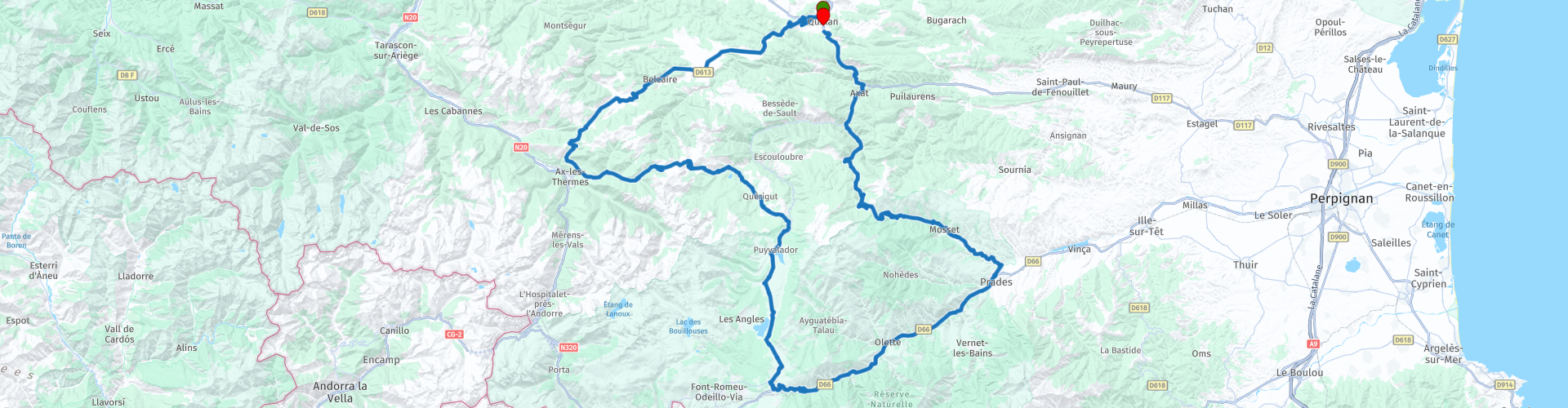
Roundtrip from Quillan to Mont Louis and Fort Liberia

This route was brought to you by:
RouteXpert Catherine De Groote RouteXpert
Last edit: 01-12-2023
 Route Summary
 As in the rest of the Languedoc-Roussillon region, traces have also been found in the Pyrénées-Orientales department that indicate that the area must have been inhabited in prehistoric times. The department was founded during the French Revolution.
The route mainly runs through the canton of Prades, which is located in the foothills of the Pyrenees. It offers beautiful scenery with mountains, forests, rivers and lakes. There are some historical sites such as the Mont-Louis citadel and Fort Libéria.
This route takes you on a journey of discovery along the roads of the Pyrénées-Orientales, where there is a true oasis of peace. During this beautiful tour you drive through beautiful forests and past small fields, with a view of the high peaks of the Pyrenees.
Mont-Louis, one of nine cities built entirely by Vauban, is a pearl of military architecture that we will take the time to visit.
Fort Libéria is located in the middle of 3 large valleys. About 50 to 100 soldiers used to live in the fort, which was built in 1681. You can enjoy the beautiful view over the mountains!
Beautiful roads, many hairpin bends and beautiful views give this route 5 stars.
 Share this route


Animation

Verdict


Duration
9h 17m

Mode of travel
Car or motorcycle

Distance
205.63 km

Countries

 RouteXpert Review
 As soon as you leave the city the road goes up. You climb in wide hairpin bends to the Col des Sept Frères. According to legend, the pass was named after a tragedy that occurred during a very harsh winter. A son, who, despite the snowstorm, goes to get the doctor in Belcaire before his sick mother disappears, a second son tries to cross, then a third and so on until the seventh. More pragmatically, the name would come from the distortion of the name 'col des sept frênes', a tree that still lines the roads of the Sault plateau.
The pass marks the watershed that separates the Mediterranean basin from the Atlantic basin.
Once you have reached the highest point, the road remains quite high: you hardly descend.
You drive to Ascou via the Col de Marmare. Now you follow the river La Lauze. The Lauze is 14.1 km long and rises near the top of Tarbésou, under the name Ruisseau de Coume Grande, and flows into the Ariège at Ax-les-Thermes.
Ascou-Pailhères is a typical winter sports resort. From here there are some beautiful hairpin bends with of course beautiful views to the Col de Pailhères.
The Col de Pailhères is a road pass located at an altitude of 2,001 meters. It is a pass that has already been climbed several times in the Tour de France and which continues via the Plateau de Bonascre or the Plateau de Beille. The Pailhères col is part of the remote and sparsely populated Donezan region. It is closed for much of the year due to the harsh climatic conditions in the upper part.
Eighteen hairpin bends further - don't forget to enjoy the majestic surroundings - there is an opportunity to strengthen the inner person. Restaurant Le Sapin Rouge in Artigues is an ideal lunch stop. Le Sapin Rouge invites you to taste delicious dishes in all simplicity and enjoy a pleasant moment on the large shaded terrace.
In Usson-les-Bains you follow the D118 along the Aude. The road continues to wind with some hairpin bends here and there.
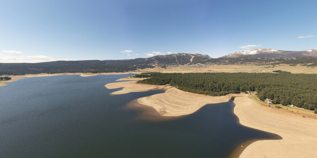
The Lac de Matemale is an artificial lake (dam) of 223 hectares. It is located at an altitude of 1541 meters. It supplies the Escouloubre hydroelectric power station and also regulates the course of the Aude. The lake is surrounded by the Matte forest, which offers a rich nature with its centuries-old Scots pines and its banks, which offer breathtaking views of the surrounding mountain peaks.
Lake Matemale is a beautiful place to relax, exercise or explore in summer.
The town of Mont-Louis, located at an altitude of 1,600 meters in the heart of the Catalan Pyrenees, is the highest fortified town in France! At the crossroads between Conflent, Capcir and Cerdagne, it was founded in the 17th century at the request of King Louis the 14th, to secure this area after the Treaty of the Pyrenees of 1659. This walled town, built from 1679 to 1681 by Vauban , also has the honor of being inscribed on the UNESCO World Heritage List as one of the Vauban fortresses.
Partly because this fortress was never actually besieged, this place is known to this day as one of the most special places in the Pyrénées-Orientales department. The many impressive fortifications have withstood the test of time. A visit to this elevated town offers a good insight into the history of military architecture. Although the fortress has never really played a crucial role in history, you really must see this special building by Vauban!
There are a few stops here and there along the N116 where you can enjoy the beautiful views. You not only follow the river Têt but also the 'Ligne de Cerdagne'.
The Yellow Train railway, built at the turn of the century, was intended to connect the Catalan highlands with the rest of the department. The first works carried out in 1903 made it possible to connect Villefranche-de-Conflent with Mont-Louis from 1910 onwards. The construction of this route required 650 structures, including 19 tunnels and two remarkable bridges: the Viaduc Séjourné (65 m above ground) and the Pont Gisclard (80 m above ground).
During the summer season you can also take this wonderful journey in an open carriage with the yellow train... and embark on a fascinating journey through the Pyrenees! From station to station, a whole heritage to discover.
Villefranche-de-Conflent is best known for its Fort Libéria, an impressive fortress. Over the centuries, the fortress was one of the most important defenses along the border with Spain.
In the year 1649, the border between modern-day France and Spain was redefined. Thanks to the new borders, the town of Villefranche-de-Conflent was located in a very strategic location. In order to protect both the place and the valley in which it is located against a possible attack from Spain, it was decided that a fort should be built here. A hill above the town of Villefranche-de-Conflent was chosen as the location. This way one could see the enemy coming from afar. In 1681, none other than the famous French fort builder Vauban was commissioned to build the fort. Six years later it was officially put into use. It was strengthened and expanded several times until the end of the nineteenth century. To this day, this fortress is known as one of the most impressive fortresses along the border between France and Spain.
From the town you can climb to the fort via the unpaved road. The view over the valley is spectacular from the ramparts. Back down you go through a tunnel with more than 750 steps!
Prades, capital of the Conflent, located at the confluence of several rivers, has a beautiful artistic heritage. What you absolutely cannot ignore is the Saint-Pierre church, from the 12th and 17th centuries. The choir houses a beautiful Baroque altarpiece, dedicated to Saint Peter. This remarkable work of art is the largest Baroque altarpiece in France!
The Castellane valley offers many beautiful views. Mediterranean landscapes dominate here. The closer you get to the Col de Jau, the more the landscape evolves into mountain landscapes.
The relatively narrow road winds via some nice hairpin bends to the top of the Col de Jau (1506 m.)
During an observation mission for the National Commando Training Center on June 29, 1968, an Army Light Aviation Cessna L-19-E made a low-altitude pass at Jau Pass to leave a message, then ascends again and suddenly turns toward left and crashes into a pine forest. The two occupants, the pilot and the chief sergeant, were killed. A memorial stone was erected at the pass in their memory.
You enter the 'Defilé de Pierre-Lys' via a tunnel cut into the mountainside. It is a beautiful stretch of road that follows the course of the Aude River through a narrow gorge. In some places large sections had to be cut out of the rock wall to accommodate the road, but that makes the route extra spectacular.
A few more kilometers along the D117 and you return to Quillan. But perhaps a last stop at the Auberge Demi-Sel for those who love delicious pancakes and desserts. The welcome is warm. It is very pleasant to spend time on the terrace.

 Links
Links  Usage
Usage Want to download this route?
You can download the route for free without MyRoute-app account. To do so, open the route and click 'save as'. Want to edit this route?
No problem, start by opening the route. Follow the tutorial and create your personal MyRoute-app account. After registration, your trial starts automatically.  Disclaimer
Use of this GPS route is at your own expense and risk. The route has been carefully composed and checked by a MyRoute-app accredited RouteXpert for use on TomTom, Garmin and MyRoute-app Navigation.
Changes may nevertheless have occurred due to changed circumstances, road diversions or seasonal closures. We therefore recommend checking each route before use.
Preferably use the route track in your navigation system. More information about the use of MyRoute-app can be found on the website under 'Community' or 'Academy'.

Occitanie
About this region
Occitanie (French pronunciation: [ɔksitani] (listen); Occitan: Occitània [utsiˈtanjɔ]; Catalan: Occitània [uksiˈtaniə]), Occitany or Occitania (), is the southernmost administrative region of metropolitan France excluding Corsica, created on 1 January 2016 from the former regions of Languedoc-Roussillon and Midi-Pyrénées. The Council of State approved Occitanie as the new name of the region on 28 September 2016, coming into effect on 30 September 2016.The modern administrative region is named after the larger cultural and historical region of Occitania, which corresponds with the southern third of France. The region Occitanie as it is today covers a territory similar to that ruled by the Counts of Toulouse in the 12th and 13th centuries. The banner of arms of the Counts of Toulouse, known colloquially as the Occitan cross, is used by the modern region and is also a popular cultural symbol. In 2015, Occitanie had a population of 5,839,867.
Read more on Wikipedia
View region
 Statistics
  83
83Amount of RX reviews (Occitanie)
 32278
32278Amount of visitors (Occitanie)
 4416
4416Amount of downloads (Occitanie)
 Route Collections in this region
 25 Magnificent trails in France
This MRA route collection contains 25 beautiful motorcycle routes in different parts of France, such as the Ardennes, the Alsace, Vercors, the Drôme, the Ardèche, Cote d'Azure, Gorges du Verdon, the Ariège, the Dordogne and Brittany.
The routes have been carefully created by Bert Loorbach, who is an enthusiastic motorcyclist himself. He lived in France for a year and a half, during which time he devoted himself to mapping the unknown and beautiful back roads of France especially for motorcyclists.
The routes are bundled in the Motortourgids France part 1 of Kosmos publishing house and now also available in MyRouteApp.
I have taken over the routes in MRA and sometimes adjusted them slightly to make them even more interesting for the motorcyclist.
View Route Collection
24 Magnificent trails in France
It is clear that France is one of the most beautiful and best touring countries. It offers an incredibly varied landscape with good roads and a pleasant climate. It is not for nothing that you see so many motorcyclists there. My previous collection of 25 routes in France (25 Magnificent routes in France) were based on the route descriptions from the Motortourgids France part 1 made by Bert Loorbach.
This collection of 24 routes comes from Motortourgids France part 2. In this collection, a difference has been made between approach routes and motorcycle tours in a certain area. The approach routes can also be used in combination with the routes from Motortourgids France part 1
The routes are sometimes slightly adjusted based on the tips that Bert Loorbach gives in his description, or because of another place to spend the night, or to reach the minimum length of 2 hours for the MRA Library. For each route, the review contains a more detailed description, including options to stay overnight or places of interest along the way, which are also indicated with a POI and if possible with a short description.
Two or more routes have been created for a number of areas, such as for Burgundy, Auvergne, The Alps, Tarn and Cévennes and Nord-Pas de Calais. These routes can be nicely combined in a multi-day trip.
View Route Collection