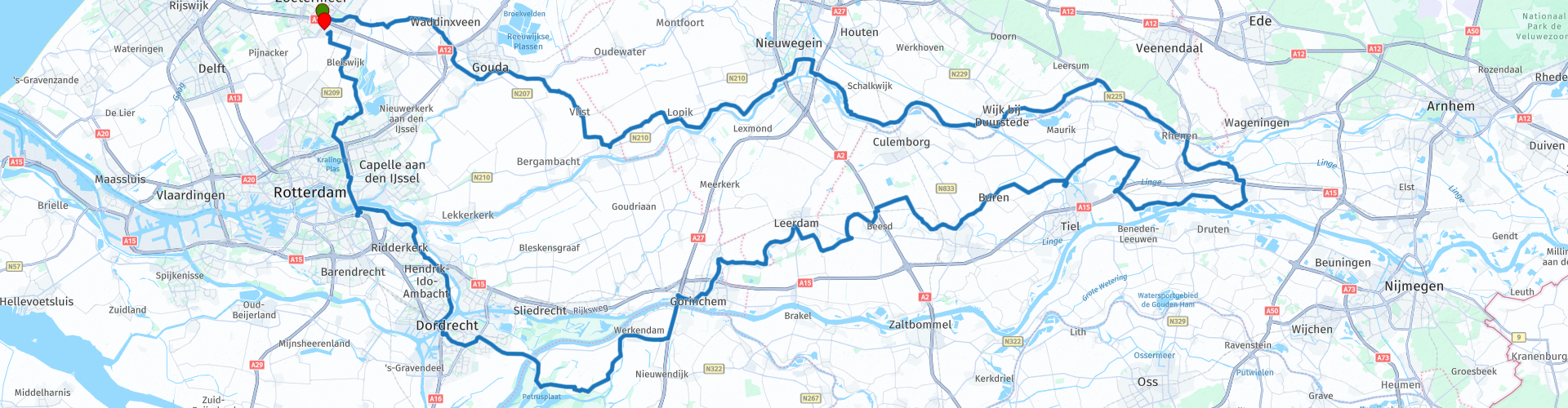
Roundtour Midden Nederland from Zoetermeer

This route was brought to you by:
RouteXpert Peter Moerman - RouteXpert
Last edit: 02-04-2021
 Route Summary
 This varied route offers something for everyone, beautiful winding dykes, polder roads, high bridges, a ferry and beautiful places. Along the way there is ample opportunity to strengthen the inner person.
I rate this route with 4 stars because of the beautiful roads, the varied landscape, the nature and the beautiful towns.
 Share this route


Animation

Verdict


Duration
9h 38m

Mode of travel
Car or motorcycle

Distance
267.01 km

Countries

 RouteXpert Review
 The Amsterdam-Rhine Canal runs from the Waal at Tiel to the IJ in Amsterdam and is 72 km long. It is the busiest canal in the world with more than 100,000 ships per year. It was opened in 1951. Further along the route you cross this canal again. After passing the canal, the route continues over the Lekdijk to Culemborg. This fortified town is already mentioned in the 13th century and since then there has also been a castle. So it has had a long and turbulent history. Today it is mainly an attractive town to visit and for now to stop for a cup of coffee or something else. There are 2 places to have a drink on the city wall.
From Culemborg the route continues towards Amerongen. Upon entering Amerongen you drive past the eponymous castle with beautiful castle gardens. A castle has been located here since 1287, destroyed by fire, and rebuilt several times. The castle was private property until 1977, after which it was sold to the Utrecht Castles Foundation. In total, the garden consists of ten hectares. Four centuries of history can be seen in the garden. The garden architects Eduard André and Hugo Poortman are the last to adapt the garden style. They modernized the garden in 1887 and 1924 for Count Van Aldenburg Bentinck. A visit is certainly worthwhile.
After Amerongen, the route continues to follow the Nederrijn to Rhenen, where you cross the bridge to the Betuwe.
The Betuwe is a region in the Dutch province of Gelderland, located between the rivers Waal in the south and the Nederrijn and Lek in the north. The Betuwe is best known for large-scale horticulture, especially fruit cultivation (apples, pears, cherries and plums). The cause of this land use lies in the geology and soil conditions of the region. Fertile river clay is found in the soil in almost the entire Betuwe.
The route meanders through the orchards and goes on beautiful winding dyke roads to Tiel where the Amsterdam-Rhine Canal is crossed again. Then you drive to Buren. The lunch stop is planned in this Oranjestad.
Buren obtained city rights in 1395 from knight Allard, lord van Buren and Beusichem. Buren's fortifications are still largely intact. There are still ramparts, walls and one city gate; the Culemborgse or Huizenpoort. Buren can call itself Oranjestad, because of the connection with the royal family. William of Orange married Anna van Buren there in 1551. Princess Beatrix and King Willem-Alexander are therefore countess and count of Buren.
After the lunch stop, you continue the route through towns such as Geldermalsen, Beesd, Asperen and Leerdam, all located on the river Linge. This river runs from Doornenburg to Gorinchem and is bisected at Tiel by the Amsterdam-Rhine Canal. At Gorinchem the route crosses the Waal to Werkendam. Unfortunately, a small stretch of highway is necessary here. At Werkendam you enter the National Park De Biesbosch.
The Dutch National Park De Biesbosch is a very water-rich nature and recreation area. Characteristic are the freshwater tides, creeks and willow tidal forests. It consists of a number of river islands and sand and mud flats in the provinces of Noord-Brabant and Zuid-Holland. In 1994 the region received the status of national park, since then it is officially called National Park De Biesbosch and is on the list of protected nature areas. The Biesbosch is partly used for agricultural purposes.
Large parts of this area are inaccessible to motorized traffic, but the route still traverses a large part of the area. Via the ferry it continues in the direction of Dordrecht and Rotterdam. Another coffee stop is planned at Ridderkerk. In good weather you can sit here on the terrace by the water. At Rotterdam, the route returns to the motorway to cross the Nieuwe Maas via the Brienenoord Bridge. The last kilometers to Zoetermeer go via Kralingse Bos and the Rottemeren. The route ends again at the parking lot at McDonald's.
You can of course start and end the tour anywhere on the route. In MRA you can adjust this at will with a little skill. You do have to schedule the stops yourself.


 Links
Links  Usage
Usage Want to download this route?
You can download the route for free without MyRoute-app account. To do so, open the route and click 'save as'. Want to edit this route?
No problem, start by opening the route. Follow the tutorial and create your personal MyRoute-app account. After registration, your trial starts automatically.  Disclaimer
Use of this GPS route is at your own expense and risk. The route has been carefully composed and checked by a MyRoute-app accredited RouteXpert for use on TomTom, Garmin and MyRoute-app Navigation.
Changes may nevertheless have occurred due to changed circumstances, road diversions or seasonal closures. We therefore recommend checking each route before use.
Preferably use the route track in your navigation system. More information about the use of MyRoute-app can be found on the website under 'Community' or 'Academy'.